Mori Atlas logo
National parkMangetti National Park

Trace the mapped boundaries of this national park within southern Africa's dry geography.

Mangetti National Park: Namibia's Protected Landscape and Geographic Context

Mangetti National Park represents a significant protected area within Namibia's distinctive arid landscapes. This page offers a geographic lens through which to understand the park's boundaries, its placement within the broader Namibian terrain, and its role as a key conservation landscape in southern Africa. Explore the mapped context of Mangetti National Park to grasp its unique geographic identity and atlas significance.

Kalahari ecosystemwoodland savannaNorthern NamibiaIUCN Category IIprotected areawildlife conservation

Mangetti National Park

National park

Park overview

Structured park overview, official facts, and landscape profile for Mangetti National Park

Mangetti National Park park facts, protected area profile, and essential visitor context

Review the core facts for Mangetti National Park, including designation, size, terrain, visitor scale, habitats, and operating context in one park-focused overview.

About Mangetti National Park

Mangetti National Park represents an important addition to Namibia's protected area network, established in 2008 to conserve the unique woodland ecosystems of the eastern Kalahari region. Located in the northern part of the country, approximately 100 kilometers southwest of Rundu, the park encompasses approximately 420 square kilometers of semi-arid woodland savanna. The landscape consists predominantly of Kalahari sandveld with interspersed woodland vegetation, creating a habitat that supports both resident and migratory wildlife species. The park's establishment reflected Namibia's broader strategy of expanding tourism infrastructure beyond the well-established Etosha National Park and coastal destinations, aiming to distribute economic benefits more widely across the country's northern regions. Management of the park emphasizes sustainable tourism development as a mechanism for reducing poverty in surrounding communities, recognizing that protected areas can serve as engines for socio-economic development when properly integrated with local stakeholder interests.

Quick facts and research context for Mangetti National Park

Mangetti National Park spans 420 square kilometers in northern Namibia, positioned within the eastern Kalahari woodland ecosystem. The park was formally established in 2008, making it one of Namibia's more recently designated protected areas. It lies approximately 100 kilometers southwest of Rundu, the largest settlement in the Kavango East Region. The protected area holds IUCN Category II designation, reflecting its status as a national park focused on ecosystem conservation and public enjoyment. Prior to its establishment, the area served as a breeding ground for rare and endangered animal species.

Protection and recognition

Analyzing terrestrial boundary classification and official conservation framework records

Documented Protection Status and Designations of Mangetti National Park

Researchers and geographers can analyze the documented terrestrial protection scope and baseline designation frameworks established for Mangetti National Park. Accessing verified database records helps clarify regional conservation boundaries and compare terrestrial management classifications within the geographic framework.

Protection details

Protection scope
Terrestrial
Transboundary protection
No
Park context

Deeper park guide and search-rich context for Mangetti National Park

Mangetti National Park history, landscape, wildlife, and travel context

Explore Mangetti National Park through its history, landscape character, ecosystems, wildlife, conservation priorities, cultural context, and seasonal travel timing in a structured park guide built for atlas discovery and search intent.

Why Mangetti National Park stands out

Mangetti National Park is particularly known for its position within the eastern Kalahari woodlands, a biome that distinguishes it from Namibia's more famous desert and coastal parks. The park protects crucial habitat within a transitional woodland zone that supports populations of rare and endangered species, a legacy of its previous use as a breeding sanctuary. The park's management philosophy centers on using tourism as a tool for regional economic development and poverty alleviation, making it significant both ecologically and socially.

Mangetti National Park history and protected-area timeline

The area that now comprises Mangetti National Park was historically utilized as a breeding ground for rare and endangered animal species before its designation as a national park in 2008. This previous function as a conservation breeding facility contributed to the area's ecological significance and provided a foundation for its transition into a protected national park. The formal establishment of the park in 2008 represented Namibia's ongoing effort to expand its network of protected areas and diversify its tourism offerings beyond the established circuits centered on Etosha and the Namib Desert. The creation of Mangetti also reflected the country's recognition of the tourism potential in the northern regions, where natural attractions could support economic development initiatives aimed at reducing poverty in some of Namibia's less wealthy areas.

Mangetti National Park landscape and geographic character

The terrain of Mangetti National Park reflects the characteristic features of the eastern Kalahari system, consisting predominantly of deep sandy soils derived from ancient dune systems interspersed with occasional outcrops of harder substrate. The vegetation patterns follow the woodland savanna classification, with scattered trees and shrubs creating a park-like appearance across much of the reserve. The landscape lacks the dramatic topographical relief found in some of Namibia's western parks, instead offering a more subtle terrain of gentle undulations and flat plains that typify the Kalahari basin. This relatively flat topography allows for excellent wildlife viewing opportunities and facilitates movement for both animals and park visitors throughout the reserve.

Mangetti National Park ecosystems, habitats, and plant life

The ecological character of Mangetti National Park centers on the eastern Kalahari woodland ecosystem, which represents a distinct biome within Namibia's protected area network. The park supports a diversity of vegetation types adapted to the semi-arid conditions, including various acacia species and other drought-resistant trees that provide important habitat structure for wildlife. The woodland environment supports both mammal species adapted to thicker vegetation cover and those preferring more open savanna areas. This transitional ecosystem position gives Mangetti ecological significance as it harbors species from multiple habitat types and supports biodiversity that might not survive in more extreme environments.

Mangetti National Park wildlife and species highlights

Mangetti National Park was historically significant as a breeding ground for rare and endangered animal species, a legacy that continues to influence its wildlife value. The park's woodland and savanna habitats support populations of various antelope species, smaller mammals, and the predator species that prey upon them. The Kalahari woodland environment provides suitable habitat for a range of faunal species adapted to semi-arid conditions, including both resident populations and seasonal visitors. While the Wikipedia source provides limited specific detail on particular species, the park's previous use as a breeding ground for rare and endangered animals indicates meaningful wildlife conservation value.

Mangetti National Park conservation status and protection priorities

The establishment of Mangetti National Park reflects Namibia's broader conservation strategy of expanding protected area coverage to include representative examples of all major biomes within the country. The park's designation as an IUCN Category II protected area indicates its primary purpose of ecosystem conservation while permitting sustainable tourism use. The management approach emphasizes tourism development as a tool for poverty reduction, recognizing that successful conservation requires tangible benefits for local communities. This integrated conservation-development model acknowledges that long-term protection of wildlife habitats depends on demonstrating economic value to surrounding populations who might otherwise view wildlife as competing for resources with livestock or agricultural interests.

Mangetti National Park cultural meaning and human context

Mangetti National Park is situated within the broader northern Namibia region, which is culturally rich and home to various ethnic groups including the Kavango people who reside in the area around Rundu. The park's establishment and management involve consideration of local community interests, particularly given the tourism-development mandate that aims to bring economic benefits to the region. While the protected area itself does not contain extensively documented heritage sites, the surrounding landscape has been inhabited by indigenous communities for generations, and traditional land-use practices continue to influence the regional context within which the park operates.

Top sights and standout views in Mangetti National Park

Mangetti National Park offers visitors the opportunity to experience the distinctive eastern Kalahari woodland environment, which differs markedly from Namibia's more famous desert and coastal landscapes. The park provides access to a relatively under-explored region of Namibia, offering wildlife viewing opportunities in a less crowded setting than more established destinations. The park's youth and development phase mean that infrastructure and visitor facilities continue to evolve, providing an opportunity to experience a developing protected area. The conservation breeding legacy contributes to wildlife populations that may be more accessible for viewing than in more remote locations.

Best time to visit Mangetti National Park

The optimal time to visit Mangetti National Park aligns with Namibia's dry winter months from May through October, when wildlife congregates around remaining water sources and vegetation is less dense, improving viewing opportunities. The cooler winter temperatures make outdoor activities more comfortable, particularly for game drives and bush walks. The wet summer season from November through April brings rainfall that can improve the landscape's appearance but may also make some roads impassable and reduce wildlife visibility as animals disperse across the expanded habitat. Visitors should note that as a relatively new park, visitor facilities and services may be more limited than in established destinations, requiring careful advance planning.

Monthly climate preview

Track the annual transition from hot dry periods to rainfall across the Namibian wilderness

Average Temperature and Weather by Month in Mangetti National Park

Based on long term climatology data, Mangetti National Park experiences extreme highs peaking in October and November alongside a prominent mid year dry spell. Accessing the full twelve month profile reveals detailed shifts in average precipitation and daily temperature ranges to clarify the regional weather by month.
Annual mean23 °C
17 °C28 °C
Jan26°
Feb25°
Mar25°
Apr23°
May20°
Jun17°
Jul17°
Aug20°
Sep25°
Oct28°
Nov28°
Dec27°
Warmest month
October

28.1 °C

Coolest month
July

16.7 °C

Wettest month
January

5.1 mm/day

Driest month
June

0 mm/day

Park location guide

Geography guide, regional context, and park location map for Mangetti National Park

Mangetti National Park park geography, regions, and map view in Namibia

Understand where Mangetti National Park sits in Namibia through a broader geographic reading of the surrounding landscape, nearby location context, and its mapped position within the national park landscape.

How Mangetti National Park fits into Namibia

Namibia is a sovereign country in Southern Africa that gained independence from South Africa in 1990. It is the driest country in sub-Saharan Africa, characterized by the Namib Desert along its coast. The population is approximately 3 million, with Windhoek as the capital and largest city. Namibia operates as a unitary semi-presidential republic with a multi-party system.

Wider geography shaping Mangetti National Park in Namibia

Namibia occupies 825,615 km2 in Southern Africa, making it the 34th largest country in the world. It is bordered by the Atlantic Ocean to the west, Angola and Zambia to the north, Botswana to the east, and South Africa to the south. The country features the Namib Desert along its coastal region, with varied terrain including savannas, mountains, and plateaus inland. A notable geographic feature is that Zimbabwe lies less than 200 metres away along the Zambezi river near Kazungula in the northeast.

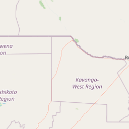
Map view of Mangetti National Park

Use this park location map to pinpoint Mangetti National Park in Namibia, understand its exact geographic position, and read its mapped placement within the surrounding landscape more clearly.

Pigeon | © OpenStreetMap contributors
Park atlas

Compare conservation landscapes, trace regional park geography, and browse protected areas surrounding Mangetti National Park in Northern Namibia.

Explore Nearby National Parks, Protected Areas, and Regional Landscapes Beyond Mangetti National Park

Continue your exploration from Mangetti National Park by discovering other national parks and protected areas across Northern Namibia's distinct Kalahari woodland savanna and its adjacent regions. Compare varied landscapes, understand regional protected area distribution, and identify key conservation efforts extending beyond Mangetti's unique transitional ecosystem.
National parkNamibia
About 147 km away#1 closest

East

Khaudum National Park: Namibia's Remote Kalahari Protected Landscape and Predatory Wildlife

Explore mapped boundaries and seasonal river ecosystems.

Khaudum National Park is a substantial protected landscape in northeastern Namibia, deep within the Kalahari Desert. This remote national park encompasses over 3,800 square kilometers of dry forest and acacia woodland, dissected by three major Omuramba dry river systems. It is globally recognized for its thriving populations of large predators like lions and spotted hyenas, alongside significant numbers of elephants and giraffes. The park's unique semi-arid terrain and biodiversity make it a key destination for understanding regional protected-area geography and landscape context.

Area
3,842 km²
IUCN
II
Relief
Lowland
Climate
Arid
National parkKunene Region
About 209 km away#2 closest

West

Etosha National Park National Park: Mapped Protected Landscape and Regional Geography

Discover its protected boundaries and geographic context.

Gain a structured understanding of Etosha National Park, a prominent national park within Namibia's Kunene Region. This entry focuses on the park's protected landscape identity, detailing its mapped boundaries and geographic significance. Explore Etosha National Park through the lens of atlas-driven discovery, appreciating its role as a key protected area and its contribution to the regional geography of the surrounding landscape.

Area
22,270 km²
Established
1907
IUCN
II
Visitors
200K annual
National parkNamibia
About 239 km away#3 closest

Southwest

Waterberg Plateau Park: A Detailed Atlas of a Protected Table Mountain in Namibia

Geographic overview of the Kalahari plateau ecosystem and protected wilderness

Waterberg Plateau Park offers a deep look into one of Namibia's most recognizable natural landmarks, featuring a classic table mountain formation that rises dramatically from the savannah. This protected area provides a rich study of geological heritage, including ancient strata and isolated plateau ecosystems that support a wide range of bird species and rare fauna. The park serves as a foundational site for conservation, marking a contrast between the elevated plateau and the expansive plains below.

Area
405 km²
Established
1972
IUCN
II
Relief
Highland
National parkAngola
About 242 km away#4 closest

Northeast

Luengue-Luiana National Park: Angola's Premier Protected Woodland and Floodplain Ecosystem

Mapping crucial habitats for large mammals and avian wildlife.

Luengue-Luiana National Park is a vital protected landscape in southeastern Angola, covering an immense area that transitions from open woodland ecosystems to vast, seasonal floodplain grasslands. As a cornerstone of the Kavango-Zambezi Transfrontier Conservation Area, it facilitates critical wildlife movements and supports significant populations of large mammals. Its geography provides essential habitat, particularly within the extensive wetland wilderness and riparian zones along the Cuando River, making it a significant site for regional biodiversity and atlas exploration.

Area
42,000 km²
Established
2011
IUCN
II
Relief
Lowland
National parkAngola
About 253 km away#5 closest

Northeast

Mavinga National Park: Protected Landscape Identity and Geographic Mapping in Angola

Explore mapped boundaries and regional context of this national park.

Mavinga National Park stands as a designated protected area within Angola, offering insights into the nation's natural landscapes and conservation efforts. This entry details the park's geographic footprint and its role as a national park. It provides users with essential map-based discovery tools to understand the park's setting, its physical geography, and its significance as a protected natural landscape in southern Africa.

Area
46,076 km²
Established
2011
IUCN
II
Relief
Lowland
National parkZambezi Region
About 254 km away#6 closest

East

Bwabwata National Park: National Park in the Zambezi Region, Namibia

Explore savanna ecosystem and riverine landscapes.

Bwabwata National Park represents a significant protected landscape in Namibia's Zambezi Region, notable for its integrated community conservation model and its function as a vital wildlife corridor. This national park spans the Caprivi Strip, featuring savanna woodlands and crucial riparian zones along the Okavango and Kwando rivers. As a key component of the Kavango-Zambezi Transfrontier Conservation Area, it facilitates significant elephant migrations, providing rich opportunities for atlas-based exploration of mapped protected areas and regional geography.

Area
6,274 km²
Established
2007
IUCN
II
Relief
Lowland
Watercolor illustration of a landscape with soft green and pink hues showing rolling hills and a pale sky
National parkNamibia
About 276 km away#7 closest

Southwest

Waterberg Plateau Park: Mapped Geography and Protected Landscape Identity in Namibia

Central Namibia's ancient plateau and savanna terrain.

Waterberg Plateau Park stands as a defining geological feature of the Namibian landscape. This national park is centered on a dramatic table mountain that creates a distinct ecological island above the surrounding Kalahari basin. Renowned for its ancient rock formations and successful conservation efforts, the area provides a vital protected boundary for endangered species and a significant focus for regional geographic exploration.

Area
405 km²
Established
1972
IUCN
II
Relief
Mixed relief
National parkAngola
About 305 km away#8 closest

Northeast

Longa-Mavinga National Park: Detailed Atlas and Protected Landscape Context in Angola

Explore its mapped boundaries and regional geographic significance.

Longa-Mavinga National Park serves as a crucial point for understanding protected areas and natural landscapes within Angola. This page details its identity as a national park, focusing on its mapped geographic features and protected land status. Users can delve into the specific landscape context and regional distribution of this significant protected area, enhancing their grasp of Angola's natural geography.

IUCN
II

Common questions about visiting, size, designation, and location context for Mangetti National Park

Mangetti National Park FAQs for park facts, access, geography, and protected area context

Find quick answers about Mangetti National Park, including protected-area facts, park geography, trail and visitor context, and how the park fits into its surrounding country and regional landscape.
MoriAtlas Explorer

Continue Your Protected Areas Search Across the Global Atlas

Deepen your exploration by continuing the structured search for national parks and protected areas worldwide. Utilize the comprehensive filtering capabilities to compare different conservation landscapes and refine your understanding of global park geography. Discover more about the distribution and characteristics of protected natural areas.

Global natural geography