Mori Atlas logo
Nature reserveMarkermeer & IJmeer

Mapping the expansive freshwater basins and dike-framed shorelines of the Dutch central provinces

Markermeer & IJmeer Nature Reserve: An Atlas of Engineered Wetlands and Lake Geography

The Markermeer & IJmeer nature reserve forms a vast, interconnected freshwater system within the Netherlands, standing as a primary example of how human water engineering shapes ecological landscapes. This protected territory encompasses open lake basins, deliberate wetland restoration zones, and complex dike-bounded boundaries that contrast with the reclaimed polders of Flevoland. Visitors can analyze the terrain where historic water management meets modern conservation, featuring a mosaic of shallow waters and newly developed habitat islands designed for regional bird populations.

freshwater lakeNatura 2000waterbirdswetland restorationshallow lakepolder landscape

Markermeer & IJmeer

Nature reserve

Park overview

Structured park overview, official facts, and landscape profile for Markermeer & IJmeer

Markermeer & IJmeer park facts, protected area profile, and essential visitor context

Review the core facts for Markermeer & IJmeer, including designation, size, terrain, visitor scale, habitats, and operating context in one park-focused overview.

About Markermeer & IJmeer

Markermeer & IJmeer is a combined lake-based Natura 2000 site that captures the ecological significance of two of the most prominent enclosed water bodies in the Netherlands. The Markermeer, the larger of the two, occupies the broad central basin enclosed by the Houtribdijk to the west, the coastline of Flevoland to the east, and the historic North Holland shore to the south. To its west, beyond the Oranjesluizen near Amsterdam, lies the smaller IJmeer, a transitional water body that connects the lake system with the urban waterfront of the Dutch capital.

The site sits in a region profoundly shaped by the Zuiderzee Works, the great twentieth-century project that dammed off the former Zuiderzee and reclaimed surrounding land as polders. The lakes themselves occupy what was once part of that inland sea, and the absence of natural shorelines is itself an expression of Dutch water management: the lakes are bounded by the Afsluitdijk-style engineering works, the Houtribdijk, polder edges, and dike roads rather than by irregular coastal features.

Ecologically, the site is recognized for its bird values above all. The shallow lake waters, soft-bottom substrates, and newly constructed nature islands such as Marker Wadden provide habitat for waterbirds and shorebirds, while reed fringes and dike-side habitats support breeding and migrating species. As a Natura 2000 site protected under both the Habitats and Birds Directives, Markermeer & IJmeer functions as a key element in the broader wetland network of the Randmeer and IJsselmeer regions, linking conservation efforts across Flevoland and North Holland.

Quick facts and research context for Markermeer & IJmeer

Markermeer & IJmeer is a designated Natura 2000 area in the Netherlands, covering roughly 11 square kilometers of habitat-type protected surface and approximately 68 square kilometers of bird-protected surface. It is referenced under area number 73 in the Dutch Natura 2000 register, with European site codes NL2003017 and NL9803029.

The site was officially designated on 23 December 2009 and is managed jointly by Staatsbosbeheer and Rijkswaterstaat, the national forestry commission and the agency responsible for waterway management. It lies within the provinces of Flevoland and North Holland, bordering municipalities that include Almere, Lelystad, Amsterdam, Diemen, Gooise Meren, Waterland, Edam-Volendam, Drechterland, Hoorn, Koggenland, Stede Broec, and Enkhuizen.

Protection and recognition

Documented conservation history, designation year, and recognized framework details

Markermeer & IJmeer Protection Status and International Recognition

Markermeer & IJmeer holds a mixed protection scope established in 2009 alongside formal international recognition through Ramsar and Natura 2000 designations. Designated frameworks provide structured reference data outlining the historical baseline and regulatory context for this protected area.

International recognition

Protection details

Protection scope
Mixed
Designated year
2009
Transboundary protection
No
Park context

Deeper park guide and search-rich context for Markermeer & IJmeer

Markermeer & IJmeer history, landscape, wildlife, and travel context

Explore Markermeer & IJmeer through its history, landscape character, ecosystems, wildlife, conservation priorities, cultural context, and seasonal travel timing in a structured park guide built for atlas discovery and search intent.

Markermeer & IJmeer history and protected-area timeline

The lake system that defines Markermeer & IJmeer is a direct product of the Zuiderzee Works, one of the most ambitious hydraulic engineering projects in Dutch history. The original Zuiderzee, an inland sea penetrating deep into the heart of the Netherlands, was closed off by the Afsluitdijk completed in 1932, transforming the open marine embayment into the freshwater IJsselmeer. Subsequent construction of the Houtribdijk between 1963 and 1976 separated the eastern IJsselmeer further into the IJsselmeer to the north and the Markermeer to the south, while the IJmeer emerged as the southwestern extension toward Amsterdam.

Although the lakes were originally conceived primarily for water management and potential future reclamation, ecological awareness grew over the decades, and the shallow lake basins became recognized for their value to waterbirds. The Markermeer & IJmeer site was formally designated as a Dutch Natura 2000 area on 23 December 2009, integrating the two water bodies into a single protected designation under both the Habitats Directive and the Birds Directive. The Marker Wadden project, which created new wetland islands within the Markermeer as part of ongoing habitat restoration, represents a later step in shaping the area's ecological future.

Markermeer & IJmeer landscape and geographic character

The landscape of Markermeer & IJmeer is dominated by open water backed by engineered edges. The lakes lack natural rocky or sandy shorelines; instead they are framed by long straight dikes, motorway embankments, the Houtribdijk between Enkhuizen and Lelystad, and the urbanization of Amsterdam's eastern waterfront. This produces a distinctive horizon: broad, flat, and interrupted mainly by wind turbines, distant towns on the polder edges, sailing vessels, and, in certain areas, low-lying nature islands rising barely above the water.

The eastern Markermeer is bordered by Flevoland, one of the largest polders in the world, with the towns of Almere and Lelystad anchoring the reclaimed land along the dikes. To the south and west, the IJmeer meets older landscapes of North Holland, including the historic lake-edge municipalities of Waterland, Gooise Meren, Edam-Volendam, and Diemen, where villages and water-oriented settlements long predate the modern lake basin. The provinces and municipalities surrounding the lakes give the site a layered context: a juxtaposition of twentieth-century polder planning and older Dutch waterside communities.

Markermeer & IJmeer ecosystems, habitats, and plant life

Ecologically, Markermeer & IJmeer represents a large freshwater lake ecosystem integrated into a wider network of shallow wetlands and polders. The water bodies are typically shallow, with soft sediment bottoms and limited natural depth variation, conditions that support the aquatic vegetation and invertebrate communities important for waterbird populations.

Habitat development within the lakes has expanded ecological complexity where natural processes alone could not provide it. Marker Wadden in particular represents an artificial archipelago of nature islands constructed to reintroduce dynamic wetland features, mudflats, and reed beds into a lake system that lacked the natural shoreline dynamics of a true sea. The reed fringes along dike edges, combined with these constructed islands, extend the ecological gradient across the protected zone and link the open water to more sheltered habitats used by fish, amphibians, and waterbirds.

Markermeer & IJmeer wildlife and species highlights

Waterbirds dominate the wildlife significance of Markermeer & IJmeer, supporting the site's special protection status under the European Birds Directive. The shallow lake environment functions as a major feeding and resting area for ducks, geese, and swans during migration and winter, while the dike-side reed beds and nature islands offer breeding habitat for several characteristic waterbird species.

Beyond birds, the lake system supports fish populations that benefit from the open connection with the IJsselmeer, as well as invertebrates and aquatic vegetation that form the base of the lake food web. Mammals such as the larger grazers occasionally seen on the nature islands are part of the wetland management approach that has been applied in nearby Natura 2000 areas like the Oostvaardersplassen, while the broader polder-edge landscape contributes additional species typical of the Dutch lowlands.

Markermeer & IJmeer conservation status and protection priorities

Markermeer & IJmeer is protected as part of the European Natura 2000 network, the largest coordinated network of protected areas in the world, established under the EU Habitats Directive and Birds Directive. Its designation on 23 December 2009 brought both the lake habitats and their associated bird populations under formal conservation oversight, obligating the Netherlands to maintain or restore favorable conservation status for the site's qualifying species and habitat types.

The site is managed jointly by Staatsbosbeheer, the Dutch national forestry and nature management agency, and Rijkswaterstaat, the agency responsible for the country's major water systems. Their combined responsibilities reflect the dual character of the area: an engineered water system requiring active hydraulic management, and an ecological area requiring habitat protection and development. Conservation measures in and around the lakes include the creation of Marker Wadden, the protection of reed fringes and shallow zones, and coordination with adjacent Natura 2000 sites such as Polder Zeevang, Lepelaarplassen, Oostvaardersplassen, and the IJsselmeer, forming a continuous ecological corridor across central Netherlands.

Markermeer & IJmeer cultural meaning and human context

The waters of the Markermeer and IJmeer are deeply intertwined with Dutch identity, particularly the long national project of reclaiming land from the sea. The lake basins replaced the southern arm of the Zuiderzee, and the engineering works that frame them, from the Afsluitdijk to the Houtribdijk, are landmarks of Dutch hydrological history. Names associated with the Zuiderzee Works, including engineer Cornelis Lely and physicist Hendrik Lorentz, recur as cultural references throughout the region.

Around the lakes, traditional Dutch waterside communities continue to define the shoreline. Villages and towns in Waterland, Gooise Meren, Edam-Volendam, and along the North Holland coast carry centuries of maritime heritage, while nearby Flevoland towns represent the planned communities of the modern polder era. Sailing, water sports, and lakeside recreation remain significant cultural uses of the lake surfaces, linking the protected area's ecological role with its strong identity as part of Dutch everyday landscape.

Top sights and standout views in Markermeer & IJmeer

Markermeer & IJmeer stands out as one of the largest freshwater lake Natura 2000 sites in the Netherlands, shaped entirely by human engineering yet ecologically rich in birdlife. Its defining qualities include the Houtribdijk-bounded Markermeer basin, the Amsterdam-facing IJmeer, and the Marker Wadden archipelago of newly created wetland islands.

It plays a central connecting role within the network of Dutch lake and polder Natura 2000 areas, linking the IJsselmeer, Lepelaarplassen, Oostvaardersplassen, and Polder Zeevang into a continuous ecological landscape. The combination of dike-fringed wilderness, open water, planned nature development, and surrounding historic villages gives the site a distinctive character within the Dutch conservation estate.

Best time to visit Markermeer & IJmeer

The lakes of Markermeer & IJmeer offer different environmental experiences across the seasons. Winter is the most important period for waterbirds, when large numbers of ducks, geese, and swans use the shallow lake zones for feeding and roosting. Spring and early summer bring the breeding season, when dike-side reed beds and nature islands host nesting waterbirds and the broader polders awaken.

Late spring through early autumn tends to be the most comfortable period for general enjoyment of the lakes, with longer daylight, milder temperatures, and active sailing and boating scenes on both the Markermeer and the IJmeer. Autumn brings migration activity, as birds move through the lake system on their way to and from wintering grounds further south.
Monthly climate preview

Review long-term average monthly temperatures and precipitation cycles for Flevoland

Markermeer & IJmeer Climate Normals and Measured Annual Temperature Patterns

Markermeer & IJmeer records measured monthly temperatures ranging from winter minimums below freezing to summer maximums approaching 27 degrees Celsius alongside steady year-round precipitation. Analyzing the full twelve-month climate profile reveals comprehensive statistical variations across the representative coordinate.
Annual mean10 °C
3 °C18 °C
Jan
Feb
Mar
Apr
May13°
Jun15°
Jul18°
Aug18°
Sep15°
Oct11°
Nov
Dec
Warmest month
August

17.9 °C

Coolest month
January

3.3 °C

Wettest month
November

2.7 mm/day

Driest month
April

1.4 mm/day

Park location guide

Geography guide, regional context, and park location map for Markermeer & IJmeer

Markermeer & IJmeer park geography, regions, and map view in Netherlands

Understand where Markermeer & IJmeer sits in Netherlands through a broader geographic reading of the surrounding landscape, nearby location context, and its mapped position within the national park landscape.

How Markermeer & IJmeer fits into Netherlands

The Netherlands is a low-lying coastal country in Northwestern Europe, famous for its extensive dike and canal systems that reclaim land from the sea. It consists of twelve provinces and is known for tulips, windmills, and cycling culture. The country is a founding member of the European Union with Amsterdam as its capital and The Hague as the seat of government.

Wider geography shaping Markermeer & IJmeer in Netherlands

The Netherlands is located in Northwestern Europe along the North Sea coastline to the north and west. It borders Germany to the east and Belgium to the south. The country is notably flat, with a significant portion of its territory lying below sea level, protected by dikes and dune systems. It consists of twelve provinces and also includes overseas municipalities in the Caribbean.

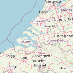
Map view of Markermeer & IJmeer

Use this park location map to pinpoint Markermeer & IJmeer in Netherlands, understand its exact geographic position, and read its mapped placement within the surrounding landscape more clearly.

Pigeon | © OpenStreetMap contributors

Location context for Markermeer & IJmeer

FlevolandNoord-Holland
Recorded earthquake history

Explore Historical Earthquake Records near Markermeer & IJmeer

Browse the MoriAtlas catalogue of recorded seismic activity associated with the Markermeer & IJmeer landscape. This structured dataset provides a clear overview of historical events, magnitudes, and epicentre locations surrounding these significant Dutch freshwater basins.

Markermeer & IJmeer Earthquake History

Catalogued events

5 events

Strongest magnitude

Magnitude 3.8

Most recent event

Sep 10, 2001

This history includes earthquakes recorded inside the park or within 50 km of its borders

Park atlas

Discover connected freshwater lake reserves, polders, and regional conservation areas.

Explore Parks Near Markermeer & IJmeer and Surrounding Protected Landscapes

Visitors exploring Markermeer & IJmeer can browse nearby protected areas and connected wetland habitats across the central Dutch water network. Regional comparisons reveal how engineered polders and shallow lake ecosystems interact within the broader conservation landscape.
National parkFlevoland
7.5 km away#1 closest

Northeast

Nieuw Land National Park: Mapped Wetland Landscape on Flevoland's Reclaimed Land

Protected area geography and ecological discovery in the Netherlands

Nieuw Land National Park offers a distinctive protected landscape forged on land recently reclaimed from the sea in the Dutch province of Flevoland. This national park is characterized by its vast expanse of wetlands, artificial islands like the Marker Wadden, and critical importance for migratory bird populations. Delve into the park's geographic context and mapped features to understand its unique conservation value and role within the wider European atlas of protected areas.

Area
289 km²
Established
2018
IUCN
II
Relief
Lowland
Nature reserveFlevoland
8.6 km away#2 closest

Southwest

Lepelaarplassen Nature Reserve: Protected Polder Wetlands and Marshland Geography

Ecologically significant wetland habitats in Flevoland

Lepelaarplassen is a protected wetland reserve situated on the edge of the young Flevoland polder. Featuring a blend of excavated lakes, willow marshes, and expansive reed fringes, the area provides essential habitat for colonial breeding birds and migratory species. This detailed look covers the landscape structure and regional geography of one of the most vital wetland zones along the Oostvaardersdijk.

Area
5 km²
Established
1971
Relief
Lowland
Access
Moderate access
Nature reserveFlevoland
About 13 km away#3 closest

South

Eemmeer & Gooimeer Zuidoever: Mapped Geography and Protected Lake-Fringe Landscape

A Natura 2000 wetland reserve within the Flevoland region

The Eemmeer & Gooimeer Zuidoever nature reserve consists of two distinct yet interconnected lake basins that represent the evolving landscape of the central Netherlands. The area is defined by its shallow water fringes and marshy shorelines, which provide essential sanctuary for waterbirds. By tracing the boundary between engineered polders and older mainland provinces, this reserve provides a unique look at the ecological significance of the former Zuiderzee remnants.

Area
15.84 km²
Established
2009
Relief
Lowland
Climate
Temperate
A horizontal watercolor painting depicting a wetland landscape with grassy foreground, bare skeletal trees, and rolling green hills under a soft, pale sky.
Nature reserveFlevoland
14 km away#4 closest

East

Oostvaardersplassen Nature Reserve: Mapped Geography and Protected Area Context

Explore the marshland and polder terrain in Flevoland, Netherlands

Oostvaardersplassen represents a landmark in modern Dutch conservation, covering a 5,600-hectare mosaic of mudflats, reed beds, and willow thickets. This nature reserve, located between Almere and Lelystad, demonstrates the evolution of a young reclaimed landscape. It provides an essential habitat for marsh birds and large herbivores within the Nationaal Park Nieuw Land region, offering a distinct study in polder-based ecological management and wetland geography.

Area
56 km²
Established
1974
Relief
Lowland
Climate
Temperate
Nature reserveNetherlands
21 km away#5 closest

Southeast

Arkemheen Nature Reserve: Geography and Protected Landscape Context in the Netherlands

Mapping medieval polder patterns and wetland bird habitats.

Arkemheen is a significant nature reserve in the Netherlands characterized by a flat, open polder landscape and historic fourteenth-century agricultural patterns. The area offers a distinct ecological profile, integrating freshwater border lakes with saline-influenced grasslands that support an internationally recognized population of meadow and wetland birds.

Area
14.3 km²
Established
1356
Relief
Lowland
Climate
Temperate
A watercolor landscape painting of a calm, shallow body of water surrounded by grassy, low-lying shores and soft, distant hills under a pale, white sky.
Protected areaNetherlands
31 km away#6 closest

North

IJsselmeer: Geography and Protected Wetland Mapping of the Netherlands

Engineered freshwater landscapes and polder geography

The IJsselmeer acts as the central freshwater reservoir for the Netherlands, providing a expansive, horizon-dominated landscape shaped by the Afsluitdijk. As an internationally recognized wetland, it supports diverse waterbird populations within its intricate system of dikes, former tidal channels, and emerging nature islands. This protected area stands as a definitive example of large-scale, adaptive hydraulic management in a low-lying coastal nation.

Area
1,133 km²
Established
1932
Relief
Lowland
Climate
Temperate
Watercolor depiction of rolling coastal dunes, blue waterways, green vegetation, and distant hills under a light sky
National parkNorth Holland
32 km away#7 closest

West

Zuid-Kennemerland National Park: Coastal Dune Protected Landscape in North Holland

Explore its unique mapped terrain and protected area geography.

Zuid-Kennemerland National Park showcases a remarkable coastal dune ecosystem situated in the North Holland province. This national park entry provides detailed insight into its protected landscape, from calcium-rich dune soils supporting rare flora to ancient woodlands and extensive walking trails. Users can explore the park's mapped boundaries, understand its geographic setting within the Netherlands, and appreciate its significance as a conservation area. Discover the natural terrain and ecological richness that characterize this important Dutch protected land.

Area
38 km²
Established
1995
IUCN
II
Visitors
1.8M annual
Protected areaNetherlands
32 km away#8 closest

Southeast

Veluwe: A Comprehensive Geographic Atlas of the Central Netherlands Protected Area

Glacial moraines, heathlands, and inland sand systems

Investigate the Veluwe, a premier protected area in the Gelderland province characterized by its historic push moraines and extensive ecological zones. The region encompasses significant sand drift complexes, dense woodlands, and vital spring-fed streams, offering a clear view of the diverse natural terrain found throughout the central Netherlands.

Area
1,000 km²
Relief
Upland
Climate
Temperate
Access
Easy access

Common questions about visiting, size, designation, and location context for Markermeer & IJmeer

Markermeer & IJmeer FAQs for park facts, access, geography, and protected area context

Find quick answers about Markermeer & IJmeer, including protected-area facts, park geography, trail and visitor context, and how the park fits into its surrounding country and regional landscape.
MoriAtlas Explorer

Continue Your Protected Areas Search Across the Global Atlas

Deepen your exploration by continuing the structured search for national parks and protected areas worldwide. Utilize the comprehensive filtering capabilities to compare different conservation landscapes and refine your understanding of global park geography. Discover more about the distribution and characteristics of protected natural areas.

Global natural geography