Mori Atlas logo
National parkMathikettan Shola National Park

Discover the mapped boundaries and regional natural landscape of this national park.

Mathikettan Shola National Park: Protected Landscape Atlas and Geographic Context in Idukki

Mathikettan Shola National Park represents a key protected area within the Idukki region of India, offering a unique window into its natural geography and landscape context. As a designated national park, its boundaries are mapped to facilitate atlas exploration and a deeper understanding of its protected terrain. This detailed entry provides structured insight into Mathikettan Shola National Park's identity as a conservation landscape, emphasizing its geographic setting and its role within the broader atlas of protected areas.

National ParkShola ForestWestern GhatsElephant CorridorKeralaIdukki District

Mathikettan Shola National Park

National park

Park overview

Structured park overview, official facts, and landscape profile for Mathikettan Shola National Park

Mathikettan Shola National Park park facts, protected area profile, and essential visitor context
Review the core facts for Mathikettan Shola National Park, including designation, size, terrain, visitor scale, habitats, and operating context in one park-focused overview.

About Mathikettan Shola National Park

Mathikettan Shola National Park represents one of Kerala's smaller but ecologically significant protected areas, established to preserve the unique shola forest ecosystem of the Western Ghats. Located in the highland region of Idukki district, the park occupies a strategic position between Eravikulam National Park to the north and Pampadam Shola National Park to the south, creating a corridor of protected montane habitat in this biodiversity-rich region. The terrain consists of rolling hills and dense forest cover, characteristic of the shola-grassland mosaic that exists above elevations of approximately 1,500 meters in the Western Ghats. The park was notified following recognition of its ecological value, particularly the importance of the Mathikettan shola as a unique forest unit with significant geological, faunal, and floristic wealth. The state government formally declared it a national park in 2008, elevating its protection status and recognizing its role as an essential elephant strip connecting fragmented wildlife habitats in the region.

Quick facts and research context for Mathikettan Shola National Park

Mathikettan Shola National Park is located in Idukki district of Kerala state, approximately 15 kilometers from Munnar town. The park was declared a protected area in 2003, though the land had been designated as a Reserve Forest since 1897 under the Travancore Government. It encompasses shola forest, a rare montane grassland ecosystem found only in the Western Ghats. The park serves as a crucial passage for elephants migrating between Bodinayakkanur and Kottamalai areas, though this corridor has been compromised by human settlements and development. An eco-sensitive zone has been notified by the central government around the park's boundary.

Park context

Deeper park guide and search-rich context for Mathikettan Shola National Park

Mathikettan Shola National Park history, landscape, wildlife, and travel context
Explore Mathikettan Shola National Park through its history, landscape character, ecosystems, wildlife, conservation priorities, cultural context, and seasonal travel timing in a structured park guide built for atlas discovery and search intent.

Why Mathikettan Shola National Park stands out

Mathikettan Shola is best known for its pristine shola forest, a distinctive ecosystem of stunted evergreen trees and rolling grasslands that characterizes the higher elevations of the Western Ghats. The park is particularly significant as an elephant corridor, providing movement routes for herds that become trapped between Bodinayakkanur and Kottamalai areas due to surrounding development pressure. The name itself, meaning 'one who had his mind confused' in Tamil, reflects the disorienting nature of the dense forest that has long intrigued local communities. The park also offers panoramic views from its viewing centers, where visitors can see across to Tamil Nadu from the mountaintops.

Mathikettan Shola National Park history and protected-area timeline

The land that now comprises Mathikettan Shola National Park was first protected as a Reserve Forest by the Travancore Government in 1897, making it one of the earliest forest designations in what would become Kerala state. Prior to its establishment as a national park, portions of the area had been leased for agricultural use, specifically for the cultivation of cardamom, a significant spice crop in the region's economy. On 21 November 2003, the area was formally declared a national park under India's wildlife protection framework, aimed at safeguarding its ecological, faunal, floral, and geographical wealth along with the surrounding environment. The state government subsequently reinforced its national park status in 2008, citing the unique nature of the shola forest and its critical importance as an elephant movement corridor. The central government has also intervened by notifying an eco-sensitive zone extending zero to one kilometer around the park's boundary, imposing restrictions on development and land use in the surrounding areas to mitigate human-wildlife conflict and habitat degradation.

Mathikettan Shola National Park landscape and geographic character

The landscape of Mathikettan Shola National Park is characterized by the distinctive shola forest ecosystem, a unique combination of stunted evergreen forests and montane grasslands found only in the higher elevations of the Western Ghats mountain range. The terrain features rolling hills with steep slopes, characteristic of the highland region near Munnar in Kerala. The forest type consists of short, dense tree cover adapted to the cool, misty conditions of the high elevation environment, interspersed with grassy glades that create the characteristic shola-grassland mosaic. The park sits at elevations that place it within the subtropical highland climate zone, with frequent mist and cloud cover throughout the year. The viewing centres within the park, known as Njandaar mettu and Uchilukuth mettu, provide elevated vantage points offering expansive views across the mountainous terrain and even glimpses of the neighboring state of Tamil Nadu on clear days.

Mathikettan Shola National Park ecosystems, habitats, and plant life

Mathikettan Shola National Park protects one of the more pristine examples of shola forest in the Western Ghats, a biome that has been significantly reduced by development and agricultural expansion across its historic range. The shola ecosystem represents a climax community of montane evergreen forest adapted to the unique climatic conditions of high-elevation South India, featuring species that have evolved specialized characteristics for survival in cool, humid conditions with frequent cloud immersion. The park's vegetation includes a rich understory of ferns, herbs, and shrubs adapted to the low-light conditions beneath the dense canopy. This forest type supports high levels of biodiversity and plays a critical role in watershed protection, with the park's forests serving as important catchments that feed streams and rivers flowing to lower elevations. The ecological significance of Mathikettan Shola extends beyond its immediate boundaries as part of a larger conservation network including adjacent protected areas that together maintain connectivity for wildlife populations.

Mathikettan Shola National Park wildlife and species highlights

The wildlife of Mathikettan Shola National Park is most notable for its elephant population, which represents a significant conservation concern for the region. Elephants from the Munnar Division regularly traverse through the Mathikettan area, using it as a corridor between Bodinayakkanur and Kottamalai. However, this traditional movement pattern has been disrupted by the expansion of private establishments on the northern side of the park and human settlements in the Chinnamanur Forest beat of the Gudalur range to the south. This habitat fragmentation has resulted in elephants becoming trapped within the park boundaries, creating human-wildlife conflict challenges for local communities. The shola forest environment supports a variety of other species typical of Western Ghats montane ecosystems, including numerous bird species, small mammals, and reptile populations adapted to the cool, humid forest conditions.

Mathikettan Shola National Park conservation status and protection priorities

Mathikettan Shola National Park represents an important conservation target within the Western Ghats, one of the world's eight most significant biodiversity hotspots. The park's declaration as a protected area reflects recognition of its unique shola forest ecosystem, which has been substantially altered across much of its historic range. Conservation efforts at Mathikettan focus on maintaining the integrity of the elephant corridor that connects wildlife populations across the region, though significant challenges remain from surrounding development. The establishment of an eco-sensitive zone by the central government demonstrates a policy approach to buffer the park from potentially damaging land uses, though enforcement and compliance remain ongoing concerns. The park's position between Eravikulam and Pampadam Shola National Parks creates potential for landscape-level conservation planning that could enhance wildlife movement and population viability across this montane region of Kerala and Tamil Nadu.

Mathikettan Shola National Park cultural meaning and human context

The cultural context of Mathikettan Shola National Park is deeply intertwined with local communities in the highland region of Idukki district. The park's name originates from Tamil, reflecting the linguistic heritage of communities who have lived in this mountainous border region between Kerala and Tamil Nadu for generations. Local understanding of the forest is captured in the phrase that gives the park its name, which suggests that one forgets the path upon entering the dense shola, a reflection of traditional knowledge about the challenging nature of this terrain. The area was historically used for cardamom cultivation under lease arrangements, a practice that shaped both the landscape and the economic relationship between local communities and the forest land. The region's proximity to Munnar, the famous hill station and tea cultivation center, connects this area to a broader cultural landscape of colonial-era development and ongoing agricultural economies centered on highland agriculture.

Top sights and standout views in Mathikettan Shola National Park

Mathikettan Shola National Park offers visitors the experience of exploring pristine shola forest in one of the Western Ghats' less-trafficked protected areas. The two viewing centres within the park, Njandaar mettu and Uchilukuth mettu, provide accessible points to experience the landscape and observe wildlife, with the added attraction of views stretching across to Tamil Nadu on the eastern horizon. The park's role as an elephant corridor gives it significance beyond its modest size, representing a critical link in the larger conservation landscape of the high mountains between Kerala and Tamil Nadu. The journey to the park through Munnar and Poopara passes through some of Kerala's most famous tea country, adding scenic value to any visit. The name Mathikettan itself, with its evocative meaning about getting lost in the forest, adds a cultural dimension that distinguishes this park from more generic protected areas.

Best time to visit Mathikettan Shola National Park

The best time to visit Mathikettan Shola National Park coincides with the post-monsoon season from October through March, when weather conditions are most favorable for exploration of the montane landscape. The monsoon months of June to September bring heavy rainfall to this highland region, which while essential for maintaining the shola forest ecosystem, can make trail conditions challenging and visibility reduced by persistent mist. The winter months from December to February offer the clearest views from the park's viewing centres and more comfortable temperatures for hiking, though evenings can be quite cold. The summer months of April and May bring warmer conditions and may offer good wildlife viewing opportunities as animals congregate at water sources, though the park's interior can feel somewhat less inviting during the hotter period. Visitors should be aware that access and facilities are limited compared to more developed parks like neighboring Eravikulam, with lodging available in Poopara rather than within the park itself.

Park location guide

Geography guide, regional context, and park location map for Mathikettan Shola National Park

Mathikettan Shola National Park park geography, regions, and map view in India
Understand where Mathikettan Shola National Park sits in India through a broader geographic reading of the surrounding landscape, nearby location context, and its mapped position within the national park landscape.

How Mathikettan Shola National Park fits into India

India is a South Asian country bordered by the Indian Ocean, Arabian Sea, and Bay of Bengal. It shares land borders with Pakistan, China, Nepal, Bhutan, Bangladesh, and Myanmar. The country has a population of over 1.4 billion people and operates as a federal parliamentary republic with its capital in New Delhi.

Wider geography shaping Mathikettan Shola National Park in India

India occupies the Indian subcontinent in South Asia, bordered by the Arabian Sea to the southwest, the Bay of Bengal to the southeast, and the Indian Ocean to the south. It shares land borders with Pakistan to the west, China, Nepal, and Bhutan to the north, and Bangladesh and Myanmar to the east. The territory also includes the Andaman and Nicobar Islands in the Indian Ocean.

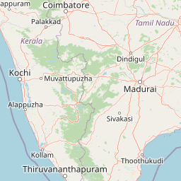
Map view of Mathikettan Shola National Park

Use this park location map to pinpoint Mathikettan Shola National Park in India, understand its exact geographic position, and read its mapped placement within the surrounding landscape more clearly.

Pigeon | © OpenStreetMap contributors

Location context for Mathikettan Shola National Park

IdukkiKerala
Park atlas

Explore the interconnected protected landscapes and montane forest ecosystems within Kerala's Western Ghats region

Discover Nearby Protected Areas and National Parks Surrounding Mathikettan Shola National Park
After exploring Mathikettan Shola National Park, continue your geographic discovery by tracing other national parks and protected areas within Kerala's high mountains. Compare adjacent protected landscapes, shola forests, and crucial elephant corridors to understand the region's conservation context and diverse ecosystems across the Western Ghats.
National parkKerala

Eravikulam National Park: National Park with Mapped Protected Boundaries in Kerala

Understanding its geographic setting and landscape identity.

Delve into the protected landscape of Eravikulam National Park, a significant national park located in Kerala. This detailed entry focuses on its geographic coordinates, mapped boundaries, and its role as a distinct protected area within the regional geography. It serves as a valuable resource for exploring the park's natural terrain and its importance in conservation landscapes.

Area
97 km²
Established
1978
IUCN
II
Visitors
148.4K annual
National parkKerala

Periyar National Park: National Park Protected Area Atlas and Geographic Context

Mapped protected lands and regional landscape exploration in Kerala.

Discover Periyar National Park as a distinct protected landscape offering rich geographic context for atlas exploration. This entry details its mapped boundaries and its significance within the broader regional geography of Kerala. Understand the natural terrain and protected-area distribution that makes Periyar National Park a key element in India's conservation mapping.

Area
350.54 km²
Established
1982
IUCN
II
Visitors
754.3K annual
Watercolor illustration of green hills, a river, and distant pink mountains
National parkKerala

Silent Valley National Park: Kerala's Protected Landscape and Geographic Atlas

Explore mapped boundaries and regional terrain in South India.

Silent Valley National Park stands as a key protected area within Kerala, India, offering rich insights into its geographic setting. This destination provides an atlas-driven view of the park's mapped boundaries, its integration with the surrounding regional geography, and the character of its natural landscapes. Users can engage with detailed information designed for structured exploration of protected natural areas and their mapped contexts.

Area
89.52 km²
Established
1984
IUCN
II
Relief
Mountain
National parkNilgiri District

Mukurthi National Park: Nilgiri District's Protected Montane Grassland and Shola Ecosystem

Explore a vital refuge for the endangered Nilgiri tahr.

Mukurthi National Park, situated in the Nilgiri District of India, is an essential protected area celebrated for its distinctive montane landscape. This national park plays a critical role in the survival of the endangered Nilgiri tahr, protecting the rare shola-grassland ecosystem where they thrive. Its dramatic terrain, high elevations, and unique ecological associations make it a focal point for understanding conservation geography and the mapped boundaries of protected lands within the Western Ghats.

Area
78.46 km²
Established
1990
IUCN
II
Relief
Mountain
Watercolor painting showing green fields, pink and yellow areas, and distant mountains
National parkNilgiri District

Mudumalai National Park: National Park Identity and Geographic Context in Nilgiri District

Mapped protected area and natural terrain details for this key Indian park.

Delve into the specific geographic identity of Mudumalai National Park, a protected national park situated in the Nilgiri District. This detail page provides access to its mapped natural landscape, helping users understand its protected boundaries and regional geographic significance. It serves as a foundational point for exploring the park's unique terrain within India's atlas of natural protected areas.

Area
321 km²
Established
1940
IUCN
II
Relief
Mountain
National parkKarnataka

Bandipur National Park: Karnataka's Protected Landscape and National Park Atlas Entry

Discover mapped terrain and diverse forest ecosystems in South India.

Bandipur National Park, a prominent national park within Karnataka, serves as a vital hub for understanding protected area geography and landscape diversity. Its ecological significance is amplified by its location at the intersection of the Deccan Plateau and the Western Ghats, supporting a unique blend of forest types and rich biodiversity. This entry provides essential context for atlas-based discovery, detailing the park's mapped terrain, its role as a tiger reserve, and its contribution to the Nilgiri Biosphere Reserve's conservation landscape.

Area
1,456.3 km²
Established
1973
IUCN
II
Relief
Mixed relief
National parkKarnataka

Nagarahole National Park: National Park within Karnataka's Protected Geography

Explore mapped boundaries and regional landscape context.

Nagarahole National Park stands as a distinct national park entity within the state of Karnataka, India. This section focuses on its specific geographic footprint and the protected landscape it encompasses, offering valuable data for users engaged in atlas-based discovery of India's conservation areas and natural terrains. Understand its mapped geography and regional significance.

Area
847.98 km²
Established
1983
IUCN
II
Relief
Upland
National parkTamil Nadu

Gulf of Mannar Marine National Park: Protected Island Archipelago and Marine Atlas

Explore India's vital marine national park and its coral reef ecosystems.

Gulf of Mannar Marine National Park is a designated national park located in Tamil Nadu, India, protecting a chain of 21 islands and their surrounding marine environments. This protected area is renowned for its extensive coral reefs, crucial seagrass meadows supporting dugongs, and diverse fish species, making it a key site for marine conservation and geographic exploration. The park's unique island landscape and intertidal zones offer a distinct perspective on coastal protected areas within the Indian Ocean, providing rich material for atlas-style discovery and understanding regional marine geography.

Area
560 km²
Established
1986
IUCN
II
Relief
Lowland

Common questions about visiting, size, designation, and location context for Mathikettan Shola National Park

Mathikettan Shola National Park FAQs for park facts, access, geography, and protected area context
Find quick answers about Mathikettan Shola National Park, including protected-area facts, park geography, trail and visitor context, and how the park fits into its surrounding country and regional landscape.
MoriAtlas Explorer

Continue Your Protected Areas Search Across the Global Atlas

Deepen your exploration by continuing the structured search for national parks and protected areas worldwide. Utilize the comprehensive filtering capabilities to compare different conservation landscapes and refine your understanding of global park geography. Discover more about the distribution and characteristics of protected natural areas.

Global natural geography