Mori Atlas logo
National parkMgahinga Gorilla National Park

A vital protected landscape spanning three dormant volcanic peaks within the transboundary Virunga mountain range.

Mgahinga Gorilla National Park: Mapping the Volcanic Terrain and Montane Ecosystems of Southwestern Uganda

Mgahinga Gorilla National Park represents a significant protected area in southwestern Uganda, where the Kisoro District landscape meets the borders of Rwanda and the Democratic Republic of the Congo. This high-elevation region encompasses three distinct volcanic peaks, Mount Muhabura, Mount Gahinga, and Mount Sabyinyo, creating a diverse terrain that transitions from dense bamboo forests to unique alpine moorlands. As a central component of the transboundary Virunga ecosystem, the park protects critical habitats for mountain gorillas and golden monkeys, standing as a pivotal site for Albertine Rift endemic species and montane conservation.

Mountain Gorilla HabitatVirunga MountainsAlbertine RiftTransboundary ConservationBamboo ForestVolcanic Landscape

Mgahinga Gorilla National Park

National park

Park overview

Structured park overview, official facts, and landscape profile for Mgahinga Gorilla National Park

Mgahinga Gorilla National Park park facts, protected area profile, and essential visitor context

Review the core facts for Mgahinga Gorilla National Park, including designation, size, terrain, visitor scale, habitats, and operating context in one park-focused overview.

About Mgahinga Gorilla National Park

Mgahinga Gorilla National Park occupies a unique position as Uganda's smallest national park yet one of its most ecologically significant. The park's defining landscape is shaped by the three volcanic peaks that rise from the Albertine Rift floor—Mount Muhabura, Mount Gahinga, and Mount Sabyinyo—each dormant but still imparting dramatic topography to the terrain. The vertical gradient from 2,227 meters at the base to 4,127 meters at the highest summit creates distinct ecological zones that support remarkable biodiversity within a relatively limited area. The park forms part of the greater Virunga ecosystem that spans three countries, making it a critical node in transboundary conservation efforts for species that require large contiguous habitats. The bamboo forest zones provide crucial feeding grounds for mountain gorillas, while the higher elevation moorlands with their distinctive tree heath communities represent one of the most restricted montane habitats in Africa.

Quick facts and research context for Mgahinga Gorilla National Park

Mgahinga Gorilla National Park covers 33.9 square kilometers in Kisoro District, approximately 15 kilometers south of Kisoro town and 55 kilometers west of Kabale. The park was formally established in 1991, though the area functioned as a game reserve from the 1930s until 1950. It forms part of the Virunga Mountains chain and protects three extinct volcanoes with a dramatic elevation profile spanning nearly 2,000 meters. The park is managed by the Ugandan Wildlife Authority and forms a contiguous protected landscape with neighboring parks in Rwanda and the Democratic Republic of the Congo.

Protection and recognition

Documented terrestrial protection metrics and official conservation status details.

Mgahinga Gorilla National Park Protection Status and Transboundary Scope

Mgahinga Gorilla National Park maintains a documented terrestrial protection status with confirmed transboundary conservation scope. Verified administrative records outline the official protected area designation and international framework details without assuming management outcomes.

Protection details

Protection scope
Terrestrial
Transboundary protection
Yes
Park context

Deeper park guide and search-rich context for Mgahinga Gorilla National Park

Mgahinga Gorilla National Park history, landscape, wildlife, and travel context

Explore Mgahinga Gorilla National Park through its history, landscape character, ecosystems, wildlife, conservation priorities, cultural context, and seasonal travel timing in a structured park guide built for atlas discovery and search intent.

Why Mgahinga Gorilla National Park stands out

Mgahinga is renowned as one of the last strongholds of the endangered mountain gorilla, with approximately 30 individuals residing in the park across one habituated and two unhabituated groups. The park is also the only known refuge for the golden monkey in Uganda, as this Albertine Rift endemic species now occurs only in the Virungas and one forest in Rwanda. The three volcanic peaks offer dramatic scenery and hiking opportunities, while the montane forest ecosystems support an exceptional concentration of Albertine Rift endemic bird species.

Mgahinga Gorilla National Park history and protected-area timeline

The area that now comprises Mgahinga Gorilla National Park was designated as a game reserve between the 1930s and 1950, though portions were subsequently converted to agricultural use at lower altitudes. Formal protection efforts accelerated in 1989 when biological surveys were initiated, wire traps destroyed, and ranger training programs established. Reforestation efforts through tree planting programs complemented these conservation measures. In the early 1990s, settlers who had established homes within the park boundaries were relocated to areas outside the national park, clearing the way for formal establishment as a national park in 1991. The park's history took an unusual turn in November 2013 when the M23 Movement, a Congolese rebel group, surrendered to authorities within the park following their defeat by the Congolese army in the M23 rebellion.

Mgahinga Gorilla National Park landscape and geographic character

The park's landscape is dominated by the three extinct volcanoes that give the Virunga range its distinctive character. Mount Muhabura rises to 4,127 meters as the highest peak within the Ugandan portion of the Virungas, while Mount Gahinga and Mount Sabyinyo complete the volcanic trio. The terrain features steep slopes descending from the volcanic summits into narrow valleys and the broader Rift floor. The park spans multiple ecological zones—bamboo forest occupies the middle elevations, transitioning to montane forest and then to the characteristic Ruwenzori-Virunga montane moorland with its dwarf tree heath vegetation at higher altitudes. The alpine zone at the summit regions represents the highest-elevation habitat in Uganda.

Mgahinga Gorilla National Park ecosystems, habitats, and plant life

The ecological significance of Mgahinga stems from its position within the Albertine Rift, one of Africa's most biodiverse regions and a recognized biodiversity hotspot. The park protects a rare constellation of habitats that includes African alpine bamboo forest, Albertine Rift montane forests, and Ruwenzori-Virunga montane moorlands. The bamboo forest zones are particularly critical as they form the primary foraging habitat for mountain gorillas. The montane moorland at higher elevations, characterized by tree heath and specialized alpine vegetation, represents one of the most restricted habitat types in Africa. The park lies within the Nile River watershed, connecting its conservation value to broader hydrological systems.

Mgahinga Gorilla National Park wildlife and species highlights

Mgahinga protects several primate species of outstanding conservation importance. The mountain gorilla population comprises approximately 30 individuals distributed across one habituated group accessible for gorilla trekking tourism and two unhabituated groups. The golden monkey, an Albertine Rift endemic whose global range is now restricted to the Virunga Mountains and a single forest in Rwanda, finds its only Ugandan population within this park. The mammal checklist of 76 species includes black-and-white colobus, leopard, African bush elephant, giant forest hog, bushpig, buffalo, Cape bushbuck, black-fronted duiker, and various rodents, bats, and small predators. The park supports an exceptional array of Albertine Rift endemic birds, with 18 species recorded during surveys in 2004 including the handsome spurfowl, dusky crimson-wing, Rwenzori turaco, and Kivu ground thrush.

Mgahinga Gorilla National Park conservation status and protection priorities

Mgahinga Gorilla National Park plays a critical role in the conservation of some of Africa's most threatened species and most restricted ecosystems. The park forms part of a transboundary conservation landscape that encompasses Volcanoes National Park in Rwanda and Virunga National Park in the Democratic Republic of the Congo, enabling the protection of wildlife populations that require large, contiguous habitats. Mountain gorillas in the Virunga massif remain endangered, and Mgahinga's population, while small, contributes to the overall viability of the regional population. The protection of the golden monkey is particularly significant given its highly restricted global range. The Albertine Rift montane forests and montane moorlands are themselves globally threatened habitats that receive formal protection within the park's boundaries.

Mgahinga Gorilla National Park cultural meaning and human context

The park is located in the Kisoro District of southwestern Uganda, an area inhabited by communities with deep cultural connections to the landscape. The local communities, including the Batwa and Bakiga peoples, have historical relationships with the Virunga Mountains that predate formal protected area establishment. The park's creation required relocation of settlers from the area in the early 1990s, a process that reflects the broader challenges of balancing conservation with community needs in Africa's mountainous border regions.

Top sights and standout views in Mgahinga Gorilla National Park

The mountain gorilla trekking experience represents Mgahinga's premier attraction, offering visitors the chance to observe these endangered primates in their natural bamboo forest habitat. The three volcanic peaks provide challenging but rewarding hiking opportunities for adventurous visitors, with the summit views offering perspectives across the Ugandan, Rwandan, and Congolese landscapes. The golden monkey encounters offer a secondary but equally memorable wildlife viewing experience in Africa's only population of this colorful Albertine Rift endemic. The transboundary location enables consideration of regional conservation significance and the interconnected nature of Virunga ecosystem protection.

Best time to visit Mgahinga Gorilla National Park

The park experiences two wet seasons—the first from February to May and the second from September to December—with rainfall varying significantly from approximately 250 millimeters in October down to just 10 millimeters in July. The drier periods, particularly June through August and January into early February, generally offer more favorable conditions for gorilla trekking and volcano hiking, as trails are less muddy and visibility is improved. The wet seasons bring lush vegetation but can make trail conditions challenging. Temperature remains relatively constant year-round due to the equatorial location, though higher elevations can be significantly cooler, especially at night.

Monthly climate preview

Long-term temperature ranges and precipitation patterns recorded at representative park elevations

Mgahinga Gorilla National Park Climate Normals and Monthly Weather Data

Representative coordinate measurements reveal sustained annual temperature bounds alongside distinct monthly precipitation variations across the protected landscape. Examining the complete twelve-month climatology dataset clarifies detailed regional meteorological rhythms for this protected area.
Annual mean17 °C
17 °C18 °C
Jan17°
Feb18°
Mar18°
Apr18°
May17°
Jun17°
Jul17°
Aug18°
Sep18°
Oct18°
Nov17°
Dec17°
Warmest month
March

18.2 °C

Coolest month
June

16.8 °C

Wettest month
November

6.7 mm/day

Driest month
July

1.2 mm/day

Park location guide

Geography guide, regional context, and park location map for Mgahinga Gorilla National Park

Mgahinga Gorilla National Park park geography, regions, and map view in Uganda

Understand where Mgahinga Gorilla National Park sits in Uganda through a broader geographic reading of the surrounding landscape, nearby location context, and its mapped position within the national park landscape.

How Mgahinga Gorilla National Park fits into Uganda

Uganda is a landlocked East African nation spanning approximately 241,000 km². It borders five countries and contains part of Lake Victoria, the world's second-largest freshwater lake. The country operates as a presidential republic with Kampala as its capital and largest city.

Wider geography shaping Mgahinga Gorilla National Park in Uganda

Uganda is situated in East Africa, bordered by Kenya to the east, South Sudan to the north, the Democratic Republic of the Congo to the west, Rwanda to the southwest, and Tanzania to the south. The southern portion includes a substantial part of Lake Victoria. The terrain features volcanic hills, mountains, and lakes.

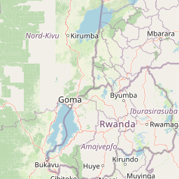
Map view of Mgahinga Gorilla National Park

Use this park location map to pinpoint Mgahinga Gorilla National Park in Uganda, understand its exact geographic position, and read its mapped placement within the surrounding landscape more clearly.

Pigeon | © OpenStreetMap contributors

Location context for Mgahinga Gorilla National Park

Kisoro District
Park atlas

Compare nearby national parks and regional protected areas within the Virunga Mountain ecosystem

Explore Other Parks Near Mgahinga Gorilla National Park and Connected Protected Landscapes

Browsing other parks near Mgahinga Gorilla National Park reveals broader conservation networks across the surrounding volcanic region. Regional park comparison exposes shared montane terrain, transboundary boundaries, and contiguous wildlife habitats.
Watercolor illustration of rolling hills, mountains, and a river or lake
National parkDemocratic Republic of the Congo
About 4.8 km away#1 closest

Northwest

Virunga National Park: Democratic Republic of the Congo's Premier Protected Landscape

Mapped boundaries and diverse Albertine Rift endemic geography.

Virunga National Park represents a pivotal protected area within the Democratic Republic of the Congo, characterized by an exceptional range of geographic features and vital ecosystems. Its protected landscape includes active volcanoes like Nyiragongo with its lava lake, the towering Rwenzori Mountains, and diverse lowland savannas. This atlas-focused entry highlights the park's unique position in the Albertine Rift, crucial for numerous endemic species and offering significant insight into regional geography and protected land context.

Area
7,800 km²
Established
1925
IUCN
II
Relief
Mountain
National parkUganda
About 10 km away#2 closest

North

Mgahinga Gorilla National Park: Atlas of Protected Volcanic Landscapes in Uganda

Mapping the Virunga Mountains and high altitude conservation terrain.

Located in southwestern Uganda, Mgahinga Gorilla National Park protects a significant portion of the transboundary Virunga ecosystem. The park encompasses the peaks of Mount Muhabura, Mount Gahinga, and Mount Sabyinyo, providing a unique look at the vertical transition of habitats from bamboo forests to alpine zones. Access detailed geographic data and spatial context for one of the most ecologically important protected areas in the Albertine Rift.

Area
33.9 km²
Established
1991
IUCN
II
Relief
Mountain
National parkRwanda
About 20 km away#3 closest

Southwest

Volcanoes National Park: Rwanda's Protected Volcanic Landscape and Regional Geography

Mapped park boundaries and East African geographic context.

Delve into Volcanoes National Park, a crucial protected area within Rwanda's northwest. This page offers detailed insight into its geography, highlighting the volcanic terrain and mapped boundaries that define this important national park. Understand its placement within the Virunga Mountains and its contribution to the natural landscape of East Africa, providing a foundation for atlas-based exploration of protected lands.

Area
160 km²
Established
1925
IUCN
II
Relief
Mountain
Watercolor painting showing green and pink trees, hills in background, and grass in foreground
National parkRwanda
About 20 km away#4 closest

Southwest

Volcans National Park: Explore its Protected Landscape and Geographic Identity

Mapped boundaries and regional natural terrain.

Volcans National Park represents a vital national park entity, offering a distinct protected landscape for geographic study. Its mapped boundaries and natural terrain provide crucial context for understanding regional geography and the broader atlas of protected areas. This page serves as a dedicated point for exploring the park's specific contribution to natural landscape discovery, focusing on its geographic character and protected status.

Area
160 km²
Established
1925
Relief
Mountain
Climate
Temperate
National parkKanungu District
About 29 km away#5 closest

North

Bwindi Impenetrable National Park: Uganda's National Park Geography and Mapped Terrain

Explore its protected landscape and regional context.

Delve into the protected landscape of Bwindi Impenetrable National Park, a protected area situated within Kanungu District, Uganda. This detail page offers a deep dive into its geographic setting, presenting mapped park boundaries and natural terrain features essential for understanding its role within the regional atlas. Discover the specific environmental context of this national park for robust map-based exploration.

Area
331 km²
Established
1991
IUCN
II
Relief
Mountain
National parkWestern Province
About 48 km away#6 closest

Southwest

Gishwati Forest National Park: Discover Rwanda's Protected Landscape Geography

Mapped protected area boundaries and regional natural landscape.

Gishwati Forest National Park offers a focused exploration of a significant protected natural landscape in Rwanda's Western Province. This resource provides detailed geographic context, highlighting the park's mapped boundaries and its role within the country's conservation areas. Understand its terrain and regional landscape importance through an atlas-centric view.

Area
32.02 km²
Established
2015
IUCN
IV
Relief
Mountain
National parkRwanda
About 48 km away#7 closest

Southwest

Gishwati-Mukura National Park: Rwanda's Protected Montane Forest Landscape in the Albertine Rift

Explore its mapped boundaries and regional geography.

Gishwati-Mukura National Park, located in western Rwanda, is a vital protected area renowned for its montane forest ecosystems. This national park occupies mountainous terrain characteristic of the Albertine Rift, contributing significantly to watershed protection and regional biodiversity. Users can explore its specific geographic context, mapped landscape features, and its role within Rwanda's broader conservation atlas.

Area
32.02 km²
Established
2015
IUCN
II
Relief
Highland
National parkKagera Region
About 105 km away#8 closest

East

Ibanda-Kyerwa National Park: Tanzania's Tri-Border Protected Landscape and Geographic Atlas

Savanna, riparian habitats, and vital regional geography exploration.

Delve into Ibanda-Kyerwa National Park, a recently established national park in Tanzania's Kagera Region. This protected area is distinguished by its critical location at the tri-border with Uganda and Rwanda, with the Kagera River system defining its unique savanna and riparian landscapes. Understanding its mapped boundaries and ecological context provides essential insight into protected land discovery in northwestern Tanzania and its role within the wider regional atlas.

Area
200 km²
Established
2019
IUCN
II
Relief
Highland

Common questions about visiting, size, designation, and location context for Mgahinga Gorilla National Park

Mgahinga Gorilla National Park FAQs for park facts, access, geography, and protected area context

Find quick answers about Mgahinga Gorilla National Park, including protected-area facts, park geography, trail and visitor context, and how the park fits into its surrounding country and regional landscape.
MoriAtlas Explorer

Continue Your Protected Areas Search Across the Global Atlas

Deepen your exploration by continuing the structured search for national parks and protected areas worldwide. Utilize the comprehensive filtering capabilities to compare different conservation landscapes and refine your understanding of global park geography. Discover more about the distribution and characteristics of protected natural areas.

Global natural geography