
Mori Atlas logo
Nature reserveMonte Prinzera

Mapping the distinctive ultramafic terrain and protected ecosystems of this Emilian peak

Monte Prinzera Nature Reserve: A Geological Landmark in the Northern Apennines of Italy

(Riserva Naturale del Monte Prinzera)

Monte Prinzera stands as the only protected ophiolite outcrop within Emilia-Romagna, forming a rugged mountain mass of peridotite and serpentinite that contrasts sharply with the surrounding clay hills. This nature reserve provides a critical study site for unique dry-soil flora and diverse wildlife, including breeding birds and woodland mammals. The site serves as a landmark for both natural history and human movement, as the historic Via Francigena traverses its slopes, offering a window into the ancient Tethys oceanic crust raised into the Apennine range.

ophioliteultramafic geologyApenninesnature reserveEmilia-Romagnaoak woodland
A flat-style vector illustration showing a mountainous landscape with a prominent dark peak, rolling green hills, and foreground silhouettes of trees under a clear blue sky.

Monte Prinzera

Nature reserve

Park overview

Structured park overview, official facts, and landscape profile for Monte Prinzera Nature Reserve

Monte Prinzera Nature Reserve park facts, protected area profile, and essential visitor context

Review the core facts for Monte Prinzera Nature Reserve, including designation, size, terrain, visitor scale, habitats, and operating context in one park-focused overview.

About Monte Prinzera Nature Reserve

Monte Prinzera is one of the most compact and thematically focused natural areas in the northern Italian Apennines, and its identity is inseparable from its geology. The mountain marks the surface expression of an ancient slice of oceanic lithosphere, transported upward during the tectonic history that built the Apennine chain. Where most of the surrounding Parma hills are clayey and gently contoured, Monte Prinzera rises as a rough, rust-colored massif whose character derives directly from its peridotite and serpentinite bedrock. These deep mantle and lower-crust rocks weather into iron-rich, low-calcium, magnesium-dominated soils that are chemically hostile to many typical Apennine plants yet ideal for a range of xerophilous specialists.

The reserve that protects it was established in 1990 precisely to safeguard this unusual combination of geology and flora. The protected area covers the mountain's summit zone, its rocky and detrital habitats, and the mixed deciduous woodlands on its lower slopes. The upper part of Monte Prinzera is dominated by herbaceous and shrubby formations, rocky outcrops, and dry European heathland; the lower flanks transition into mixed oak woodland, chestnut groves, seminatural xerophilous grasslands and pastures, and small pockets of agricultural land with broadleaf trees such as willow and poplar. The result is a steep ecological gradient compressed into a very small area, where alpine, Mediterranean, and sub-Mediterranean influences meet on unusual soil chemistry.

Culturally and historically, the mountain lies along the ancient Via Francigena, the medieval pilgrimage route that once linked Canterbury to Rome. The local stretch between Bardone and Terenzo crosses the reserve's territory, adding a layer of long-distance travel heritage to the natural value of the site. Visually, Monte Prinzera is marked from below by the tightly winding curves of the Strada Statale 62 della Cisa near the hamlet of Piantonia, and by the prominent television repeater that crowns its summit.

Quick facts and research context for Monte Prinzera Nature Reserve

Monte Prinzera is a 736-meter mountain located in the province of Parma, in the Emilia-Romagna region of northern Italy. It lies at the northern edge of the Apennine chain and gives its name to a nature reserve established in 1990. The mountain is famous among geologists as the region's only protected ophiolite outcrop, with dominant peridotites and serpentinites that produce iron- and magnesium-rich, silica-poor ultramafic soils. These soils support xerophilous grasslands, dry European heathland, and relict mixed deciduous woodland dominated by oaks and chestnut. The site is registered in the European Natura 2000 network under the code IT4020006.

Protection and recognition

Terrestrial conservation scope and Natura 2000 designation records

Monte Prinzera Protection Status and International Recognition Data

Monte Prinzera maintains documented terrestrial protection status alongside verified Natura 2000 recognition records. Structured conservation data details the established management scope and official administrative boundaries.

International recognition

Protection details

Protection scope
Terrestrial
Transboundary protection
No
Park context

Deeper park guide and search-rich context for Monte Prinzera Nature Reserve

Monte Prinzera Nature Reserve history, landscape, wildlife, and travel context

Explore Monte Prinzera Nature Reserve through its history, landscape character, ecosystems, wildlife, conservation priorities, cultural context, and seasonal travel timing in a structured park guide built for atlas discovery and search intent.

Why Monte Prinzera Nature Reserve stands out

Monte Prinzera is best known for being the only protected ophiolite outcrop in Emilia-Romagna, an exposed fragment of ancient Tethys oceanic crust raised into the Apennine chain. Its peridotite and serpentinite bedrock gives the slopes their unusual rust-red color and produces chemically extreme soils that sustain rare, slow-growing dry Mediterranean flora atypical for the surrounding Emilian hills. The combination of ultrabasic geology and protected xerophilous vegetation makes the reserve a benchmark site for studying Apennine ultramafic ecology.
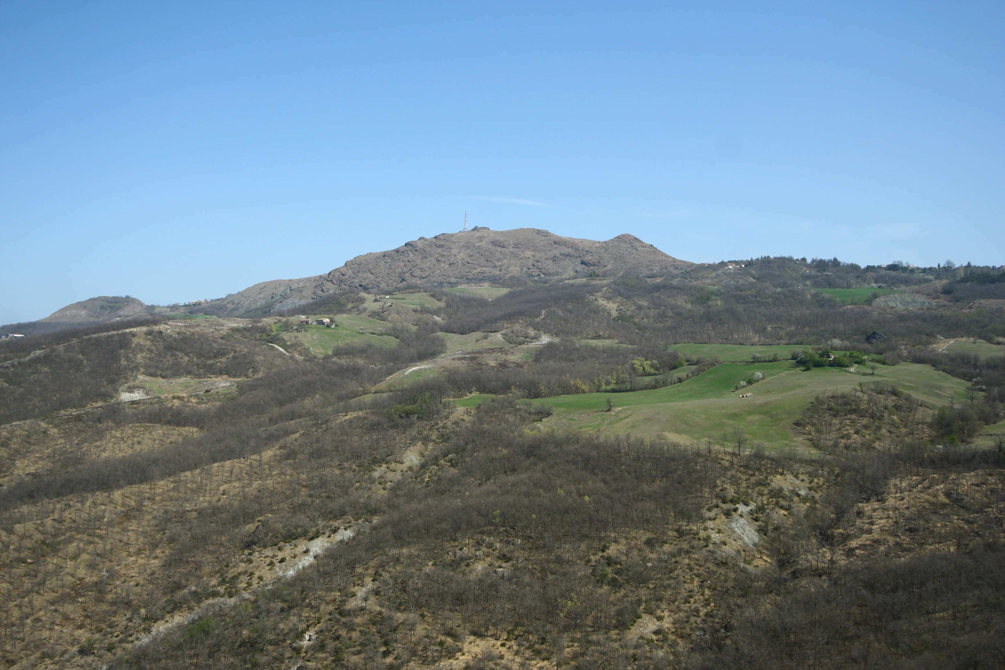
A panoramic mountain landscape view showing the rocky, sparse ridgeline of Monte Prinzera rising above rolling, scrubby hills and patches of green fields under a clear blue sky.
A wide view of the Monte Prinzera mountain landscape in the Emilia-Romagna region of Italy.

Monte Prinzera Nature Reserve history and protected-area timeline

The Monte Prinzera Nature Reserve was officially established in 1990, formalizing decades of growing scientific interest in the mountain's unusual geological and botanical profile. Geologists had long recognized the site as the only exposed ophiolite sequence in Emilia-Romagna, a fragment of ancient oceanic crust preserved within the Apennine fold-and-thrust belt.

The protection reflected a broader shift in regional conservation policy toward safeguarding small but geologically or ecologically distinctive sites, rather than only larger forested parks. The reserve was designed to balance the preservation of the ultramafic habitats and their rare spontaneous flora with the cultural landscape of the surrounding hills, including traditional chestnut cultivation and seminatural pastoral land use that had shaped the lower slopes for centuries.

The mountain's territory had already carried historical human significance long before formal protection, thanks to its position along the Via Francigena between Bardone and Terenzo, and to its visibility from the Strada Statale 62 della Cisa, one of the historic crossing routes between Emilia and Tuscany.

Monte Prinzera Nature Reserve landscape and geographic character

The landscape of Monte Prinzera is defined by contrast. Set among the smooth, clay-rich hills of the Parma Apennine foothills, the mountain rises as a compact, rugged mass whose color and texture immediately distinguish it from its surroundings. Its summit reaches 736 meters, while the neighboring Monte Prinzerolo reaches 582 meters, and the two together shape a small but visually dominant ridge system.

The defining visual signature of the mountain is its deep rust-red hue, produced by the weathering of peridotite and serpentinite rocks. These ultrabasic outcrops are rough, dark when fresh, and oxidize to warm reddish tones that stand out against the paler soil and vegetation of the surrounding hills. The terrain is steep and rocky in the upper part, becoming gentler and more forested toward the base, where chestnut woods and mixed oak forest cloak the slopes.

From the lower road network, particularly the winding sections of the Strada Statale 62 della Cisa near Piantonia, the mountain appears as a single bold promontory crowned by a tall television repeater, an unmistakable local landmark whose silhouette frames views of the reserve from the surrounding valleys.

Monte Prinzera Nature Reserve ecosystems, habitats, and plant life

Ecologically, Monte Prinzera is best understood as a small ultramafic island embedded in a sea of more conventional Apennine habitat. The chemical character of its bedrock, iron- and magnesium-rich, silica-poor, produces shallow, sometimes toxic soils that filter which plants can establish themselves on the slope. This has made the summit and upper flanks a refuge for a set of species that are rare or absent elsewhere in Emilia-Romagna.

The vertical ecological zonation is unusually sharp for such a modest elevation. The highest parts feature rocky and detrital habitats, sparse herbaceous and shrubby formations, and patches of dry European heathland. Moving downward, the vegetation shifts into mixed deciduous woodland dominated by oaks, alongside chestnut stands and seminatural xerophilous grasslands and pastures. Along the lowest edges of the protected area, small agricultural plots coexist with isolated willows and poplars, maintaining a traditional rural mosaic at the interface between forest and farmland.

This compressed gradient means that visitors moving through the reserve can pass, within a short distance, from relict dryland vegetation reminiscent of more southerly Mediterranean landscapes to humid broadleaf forest more typical of the northern Apennine foothills.

Monte Prinzera Nature Reserve wildlife and species highlights

The wildlife of Monte Prinzera reflects the dual character of the reserve: a mosaic of dry rocky habitats above and wooded, agricultural-fringe habitat below. Bats are a particular feature, with multiple species recorded, including the greater horseshoe bat (Rhinolophus ferrumequinum) and Savi's pipistrelle (Hypsugo savii), which find shelter in the rocky outcrops and old trees.

The crested porcupine (Hystrix cristata) has been documented in the area, and the wolf is recorded as an increasingly regular presence, reflecting the broader recovery of large carnivores across the northern Apennines. The reserve also hosts around twenty bird species of Community Interest under the European Habitats Directive, with at least five confirmed breeding species.

Typical breeding birds include nightjar, red-backed shrike, and ortolan bunting, while agricultural-habitat species such as hoopoe and swallow are regularly present. Forest-edge species like common redstart and black-eared wheatear also frequent the mixed woodland, while others such as woodlark, tawny pipit, and short-toed snake eagle appear less frequently, adding to the site's value for ornithological observation.

Monte Prinzera Nature Reserve conservation status and protection priorities

The conservation significance of Monte Prinzera rests on three linked layers: geological, floristic, and landscape-cultural. As the only protected exposure of ophiolites in all of Emilia-Romagna, the reserve preserves a tangible record of the ancient oceanic crust that once lay between the European and African plates, now raised into the Apennine chain. This makes the site a reference point for geological education and research.

Its ultramafic substrate hosts a set of dry, often relict plant communities that are rare within the regional context, and protecting them requires maintaining the characteristic low-intensity land use of the surrounding slopes, particularly the seminatural pastures and chestnut groves that buffer the most sensitive habitats.

The site is integrated into the European Natura 2000 network under the designation IT4020006, placing it within the framework of community-level biodiversity protection and reinforcing the importance of the mountain's combination of ultrabasic soils, xerophilous vegetation, woodland, and traditional rural mosaics.

Monte Prinzera Nature Reserve cultural meaning and human context

Monte Prinzera's cultural context blends ancient travel heritage with traditional rural land use in the Parma Apennines. The mountain lies along a stretch of the Via Francigena, the great medieval pilgrimage route between Canterbury and Rome, between the localities of Bardone and Terenzo, embedding the natural area within a long history of long-distance travel and devotion. The presence of the chestnut woods at the base of the slopes also speaks to a centuries-old tradition of chestnuts as a staple food and timber resource in these foothills.

The surrounding hills carry the imprint of seminatural pastoralism and small-scale cereal cultivation, practices that have shaped both the landscape character and the ecological value of the reserve's lower zones, and that remain central to how the protected area is managed today.

Top sights and standout views in Monte Prinzera Nature Reserve

Monte Prinzera's defining highlight is its status as Emilia-Romagna's only protected ophiolite outcrop, where ancient oceanic crust forms a rust-red mountain that visibly contrasts with the surrounding Apennine foothills. The reserve protects rare dry and rocky flora on chemically unusual ultramafic soils, nested within a gradient that descends into mixed oak and chestnut forest and traditional rural land use.

Birdlife is another strong draw, with around twenty species of European conservation interest, including breeding nightjars, red-backed shrikes, and ortolan buntings. Bats, crested porcupine, and an expanding presence of wolf round out a fauna that, while not spectacular in species count, is unusually balanced between Mediterranean, woodland, and agricultural-edge communities compressed into a compact protected area.

Best time to visit Monte Prinzera Nature Reserve

Monte Prinzera can be visited meaningfully across much of the year, with distinct seasonal advantages. Spring and early summer are particularly rewarding for observing the reserve's rare dry-habitat flora at peak flowering, when the xerophilous grasslands and heathland communities on the upper slopes are most visible, and bird activity, including breeding nightjars and red-backed shrikes, is at its height.

Late spring and early autumn also offer mild conditions for walking the historic stretch of the Via Francigena between Bardone and Terenzo, which crosses the reserve. Summer tends to be hot and dry, accentuating the Mediterranean character of the upper slopes but making the open rocky terrain more exposed, while autumn brings the rich colors of chestnut and oak woodland on the lower flanks. Winter generally brings cooler, quieter conditions, with the red tones of the ultrabasic rock standing out strongly against the bare vegetation.

Monthly climate preview

Long-term monthly temperature ranges and precipitation patterns for Monte Prinzera

Monte Prinzera Climate Normals: Measured Annual Temperature and Precipitation Rhythm

Historical coordinate data reveals the measured annual temperature and precipitation rhythm across twelve distinct monthly intervals at Monte Prinzera. Reviewing the complete twelve-month profile provides detailed meteorological context for evaluating local climate variations.
Annual mean12 °C
3 °C23 °C
Jan
Feb
Mar
Apr11°
May15°
Jun20°
Jul23°
Aug23°
Sep18°
Oct13°
Nov
Dec
Warmest month
July

22.9 °C

Coolest month
January

2.5 °C

Wettest month
November

4.1 mm/day

Driest month
July

1.2 mm/day

Park location guide

Geography guide, regional context, and park location map for Monte Prinzera Nature Reserve

Monte Prinzera Nature Reserve park geography, regions, and map view in Italy

Understand where Monte Prinzera Nature Reserve sits in Italy through a broader geographic reading of the surrounding landscape, nearby location context, and its mapped position within the national park landscape.

How Monte Prinzera Nature Reserve fits into Italy

Italy is a unitary parliamentary republic in Southern and Western Europe, located on the Italian Peninsula with the Alps to the north. It borders France, Switzerland, Austria, Slovenia, Vatican City, and San Marino, and shares maritime boundaries with several Mediterranean countries. The country has approximately 59 million residents and uses the Euro as its currency.

Wider geography shaping Monte Prinzera Nature Reserve in Italy

Italy occupies a boot-shaped peninsula in southern Europe, bordered by the Alps to the north. It shares land borders with France, Switzerland, Austria, Slovenia, Vatican City, and San Marino. The country includes the Mediterranean islands of Sicily and Sardinia, along with approximately 800 smaller islands.

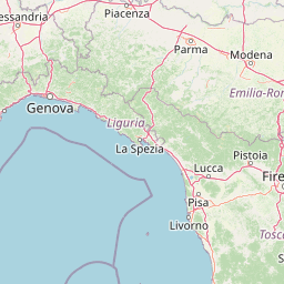
Map view of Monte Prinzera Nature Reserve

Use this park location map to pinpoint Monte Prinzera Nature Reserve in Italy, understand its exact geographic position, and read its mapped placement within the surrounding landscape more clearly.

Pigeon | © OpenStreetMap contributors

Location context for Monte Prinzera Nature Reserve

Emilia-Romagna
Recorded earthquake history

Review the Historical Earthquake Catalogue for Monte Prinzera

Discover the documented history of seismic events occurring in the vicinity of the Monte Prinzera nature reserve. MoriAtlas provides a clear, organized view of recorded earthquake data, allowing you to examine regional seismic activity patterns through a structured geographic lens.

Monte Prinzera Earthquake History

Catalogued events

413 events

Strongest magnitude

Magnitude 5.8

Most recent event

May 22, 2024

This history includes earthquakes recorded inside the park or within 50 km of its borders

Explore photographic records of rare ultramafic rock formations, rugged terrain, and protected habitats.

Monte Prinzera Photos and Landscape Scenery: Visualizing the Unique Ophiolite Reserve

Examine curated photographic evidence showcasing the distinct rust-red peridotite slopes and mixed woodland environments of Monte Prinzera. Visual records provide essential geographical context for understanding the rare geological and ecological character of the Apennine reserve.

A panoramic mountain landscape view showing the rocky, sparse ridgeline of Monte Prinzera rising above rolling, scrubby hills and patches of green fields under a clear blue sky.

Park atlas

Discover related reserves and regional protected landscapes across the northern Apennines

Explore Parks Near Monte Prinzera and Surrounding Protected Areas

Compare Monte Prinzera with other protected areas and regional nature reserves across the surrounding Apennine foothills. Broaden your geographic exploration by examining nearby terrain, geological formations, and protected landscapes.
Watercolor painting of rolling green hills under a sunset sky with soft color transitions
National parkEmilia-Romagna
16 km away#1 closest

South

Appennino Tosco-Emiliano National Park: Explore Its National Park Boundaries and Geography

Discover the mapped landscape and regional context of this protected area.

Appennino Tosco-Emiliano National Park is a designated national park offering a rich area for geographic exploration. This MoriAtlas entry details the park's protected landscape, providing insights into its mapped boundaries and its contribution to the natural terrain of the Emilia-Romagna region. Understand its significance within the broader atlas of Italian protected areas, focusing on its unique geographic identity and landscape context.

Area
227.92 km²
Established
2001
IUCN
II
Relief
Mountain
Nature reserveEmilia-Romagna
About 35 km away#2 closest

Northeast

Riserva naturale di Torrile e Trecasali: Protected Wetland Geography in Emilia-Romagna

A regional nature reserve and migratory bird sanctuary

Located in the lowlands of the Po Valley, Riserva naturale di Torrile e Trecasali protects a concentrated variety of freshwater habitats. From reed-fringed canals to seasonal flood meadows, this site provides essential mapping context for understanding lowland riparian corridors and their role in regional biodiversity within northern Italy.

Area
1.09 km²
Established
2010
IUCN
IV
A watercolor illustration of rolling hills with gypsum rock outcrops and flowering shrubs in the foreground.
Biosphere reserveEmilia-Romagna
About 36 km away#3 closest

Southeast

Carsismo e grotte evaporitiche dell'Appennino settentrionale Protected Geological Reserve

Evaporite karst landscapes within the Emilia-Romagna region.

Spanning across northern Italy, this site features a dense concentration of gypsum caves and sculpted karst terrain. It stands as a premier example of evaporite geomorphology, with record-breaking cave depths and diverse formations that offer a deep look into the geological history of the northern Apennines.

Established
2023
Relief
Mountain
Scope
Terrestrial
Water
Minor water
Marine protected areaFrance
60 km away#4 closest

Southwest

Sanctuaire Pelagos Marine Protected Area: Mediterranean Geography and Seascape

A transboundary conservation zone spanning 87,500 square kilometers.

Sanctuaire Pelagos represents a unique collaborative effort in marine conservation across the Mediterranean. Spanning the waters between France, Italy, and Monaco, this protected maritime area is defined by its deep-sea canyons and nutrient-rich currents that sustain diverse cetacean populations. Its immense scale and international governance make it a focal point for understanding Mediterranean marine biodiversity and environmental policy.

Area
87,500 km²
Established
1999
IUCN
IV
Relief
Lowland
Watercolor illustration of a mountainous coastal landscape with green vegetation and a body of water
National parkLiguria
About 63 km away#5 closest

Southwest

Cinque Terre National Park: Protected Area Geography and Mapped Landscape

Explore its regional context in Liguria, Italy.

Examine Cinque Terre National Park as a key protected area within the rugged geography of Italy's Liguria region. This dedicated atlas entry provides essential geographic context, detailing the park's mapped boundaries and its significance as a national park. Understand how this protected landscape fits within the broader regional terrain, offering a structured view for geographic discovery and map-based exploration of Italy's protected areas.

Area
22 km²
Established
1999
IUCN
V
Relief
Mountain
Nature reserveLombardia
About 93 km away#6 closest

Northwest

Riserva naturale garzaia di Porta Chiossa: Protected Woodland and Heronry in Lombardia

Historic lowland forest and bird sanctuary geography

Located in the heart of the Po Plain, this nature reserve maintains an essential mosaic of wet woodland and riverine trees. Explore the boundaries of this ecological sanctuary, which remains one of the few surviving sections of the ancient Visconti hunting grounds, offering a unique window into the natural history of the Lombardy region.

Area
0.8 km²
Established
1984
IUCN
IV
National parkTuscany
129 km away#7 closest

South

Arcipelago Toscano National Park: Protected Islands and Mediterranean Landscape Atlas

Explore Tuscany's unique archipelago geography and protected natural terrain.

Arcipelago Toscano National Park offers a unique perspective on Mediterranean island ecosystems through its comprehensive atlas and mapped landscape context. Covering seven main islands and surrounding marine areas off the coast of Tuscany, this park protects dramatic granite cliffs, endemic flora, and vital habitats for marine and avian life. Understand its geographic scope, protected boundaries, and the distinctive natural terrain that defines this significant Italian conservation landscape.

Area
746.63 km²
Established
1996
IUCN
II
Relief
Mixed relief
A pale, soft-focus watercolor painting of rolling green hills, a forested valley, and layered distant mountains.
Nature reserveLiguria
135 km away#8 closest

West

Riserva naturalistica dell'Adelasia: Protected Forest Landscapes and Geography in Liguria, Italy

A woodland nature reserve and legendary ridge landscape in the upper Bormida valley

Spanning elevations between 400 and 860 meters, Riserva naturalistica dell'Adelasia anchors the northern flank of the Ligurian Apennines. This nature reserve provides essential habitat in a historically industrialized valley, featuring a mix of mature forest, cascading stream corridors, and the iconic Rocca dell'Adelasia landmark, which ties the region to local folklore and historic geography.

Established
1989
Relief
Mountain
Climate
Temperate
Scope
Terrestrial

Common questions about visiting, size, designation, and location context for Monte Prinzera Nature Reserve

Monte Prinzera Nature Reserve FAQs for park facts, access, geography, and protected area context

Find quick answers about Monte Prinzera Nature Reserve, including protected-area facts, park geography, trail and visitor context, and how the park fits into its surrounding country and regional landscape.
MoriAtlas Explorer

Continue Your Protected Areas Search Across the Global Atlas

Deepen your exploration by continuing the structured search for national parks and protected areas worldwide. Utilize the comprehensive filtering capabilities to compare different conservation landscapes and refine your understanding of global park geography. Discover more about the distribution and characteristics of protected natural areas.

Global natural geography