Mori Atlas logo
National parkMount Cameroon National Park

Discover the mapped boundaries and natural terrain of this key protected area in Cameroon's atlas.

Mount Cameroon National Park: National Park Protected Landscape and Regional Geography in Cameroon

Mount Cameroon National Park stands as a significant protected landscape within Cameroon, offering a unique vantage point for exploring Central Africa's geography. As a designated national park, its mapped boundaries define an area crucial for understanding regional conservation efforts and natural terrain. This page provides detailed atlas-style insights into the park's geographic context, allowing for a focused discovery of its protected-area identity and its place within the broader landscape of Cameroon.

volcanic landscapemountain parkCongo BasinWest Africatropical forestalpine environment

Mount Cameroon National Park

National park

Park overview

Structured park overview, official facts, and landscape profile for Mount Cameroon National Park

Mount Cameroon National Park park facts, protected area profile, and essential visitor context

Review the core facts for Mount Cameroon National Park, including designation, size, terrain, visitor scale, habitats, and operating context in one park-focused overview.

About Mount Cameroon National Park

Mount Cameroon National Park is a protected area in southwestern Cameroon, encompassing the slopes and summit region of Mount Cameroon, the highest peak in Central and West Africa. The park covers the volcanic mountain that rises dramatically from the Atlantic coast to an elevation of 4,095 meters, creating a remarkable diversity of ecosystems within a relatively compact area. The mountain is an active volcano, with recent eruptions contributing to the region's dynamic landscape and fertile soils. The park is notable for its ecological gradient, transitioning from coastal lowland forests through montane zones to alpine meadows near the summit, making it one of the most biodiverse areas in the Congo Basin region.

Quick facts and research context for Mount Cameroon National Park

Mount Cameroon National Park is located in the Southwest Region of Cameroon, approximately 150 kilometers inland from the Atlantic coast. The protected area surrounds Mount Cameroon, an active stratovolcano and the highest mountain in West and Central Africa. The park features dramatic elevation changes spanning from near sea level to over 4,000 meters, creating multiple distinct ecological zones. The volcanic origin of the mountain has produced fertile soils that support rich vegetation communities.

Protection and recognition

Verifying the official conservation status and boundary data within global protected area datasets

Mount Cameroon National Park Protection Status and Conservation Designations

Mount Cameroon National Park represents a major African ecological zone requiring verified tracking of its legal designations, boundaries, and international status. Reviewing structured geographical records offers valuable insight into how regional frameworks align with global environmental databases to safeguard montane habitats.

Protection details

Transboundary protection
No
Park context

Deeper park guide and search-rich context for Mount Cameroon National Park

Mount Cameroon National Park history, landscape, wildlife, and travel context

Explore Mount Cameroon National Park through its history, landscape character, ecosystems, wildlife, conservation priorities, cultural context, and seasonal travel timing in a structured park guide built for atlas discovery and search intent.

Why Mount Cameroon National Park stands out

Mount Cameroon is best known as the highest mountain in West and Central Africa, rising to 4,095 meters above sea level. The national park protects this active volcanic peak and its surrounding ecosystems, which represent an important center of biodiversity in the Congo Basin. The mountain's volcanic activity has produced frequent eruptions throughout history, most notably in 2000, making it one of the most active volcanoes in the region. The park is also recognized for its exceptional ecological diversity, with vegetation zones ranging from lowland tropical forests through montane forest to alpine grasslands.

Monthly climate preview

Long-term temperature ranges and monthly precipitation rhythm for representative park coordinates

Mount Cameroon National Park Climate Normals and Annual Weather Patterns

Historical climate records from 1991 to 2020 document measured shifts in monthly temperature and precipitation across representative park coordinates. Examining the complete twelve-month profile clarifies long-term thermal variations and rainfall distribution patterns throughout the protected area.
Annual mean26 °C
24 °C27 °C
Jan26°
Feb27°
Mar27°
Apr27°
May26°
Jun25°
Jul24°
Aug24°
Sep25°
Oct25°
Nov26°
Dec26°
Warmest month
February

26.9 °C

Coolest month
August

24.1 °C

Wettest month
July

11.7 mm/day

Driest month
December

0.9 mm/day

Park location guide

Geography guide, regional context, and park location map for Mount Cameroon National Park

Mount Cameroon National Park park geography, regions, and map view in Cameroon

Understand where Mount Cameroon National Park sits in Cameroon through a broader geographic reading of the surrounding landscape, nearby location context, and its mapped position within the national park landscape.

How Mount Cameroon National Park fits into Cameroon

Cameroon is a Central African country spanning coastal, highland, and forest regions. It has a population of nearly 31 million people who speak 250 native languages alongside English and French as official languages. The country gained independence from France in 1960 and unified with British Southern Cameroons in 1961.

Wider geography shaping Mount Cameroon National Park in Cameroon

Cameroon is located in Central Africa, bordering Nigeria and Chad to the west and north, the Central African Republic to the east, and Equatorial Guinea, Gabon, and the Republic of the Congo to the south. The country has a coastline on the Bight of Biafra, part of the Gulf of Guinea. Terrain includes coastal plains, mountainous highlands (including Mount Cameroon), plateaus, and dense rainforest regions.

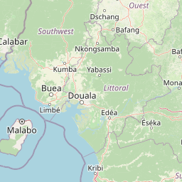
Map view of Mount Cameroon National Park

Use this park location map to pinpoint Mount Cameroon National Park in Cameroon, understand its exact geographic position, and read its mapped placement within the surrounding landscape more clearly.

Pigeon | © OpenStreetMap contributors
Park atlas

Trace the broader geographic context and protected-area spread surrounding Mount Cameroon's volcanic slopes.

Explore Related National Parks, Protected Areas, and Regional Geography near Mount Cameroon National Park

Continue your discovery beyond Mount Cameroon National Park by browsing other national parks and protected areas within its surrounding regional geography and diverse ecological zones. Compare their unique landscapes, conservation priorities, and geographic context to deepen your understanding of the West and Central African protected-area atlas.
National parkCameroon
About 54 km away#1 closest

Southeast

Douala-Edéa National Park: Coastal Mangrove and Tropical Forest Protected Landscape

Explore Cameroon's vital protected national park geography.

Douala-Edéa National Park is a protected national park in Cameroon's Littoral Region, defined by its extensive coastal geography where tropical lowland equatorial forests merge with significant Atlantic mangrove ecosystems. This area, encompassing roughly 2,715 square kilometers along the Bight of Biafra and the Sanaga River estuary, offers rich context for understanding Central Africa's coastal protected lands and diverse natural landscapes.

Area
2,715.12 km²
Established
2018
IUCN
II
Relief
Lowland
National parkBioko Norte
About 83 km away#2 closest

Southwest

Pico Basilé National Park: Volcanic Peak National Park and Protected Landscape

Explore Bioko Norte's unique montane terrain and rich avifauna.

Pico Basilé National Park is a critical conservation zone encompassing Equatorial Guinea's highest point, Pico Basilé volcano. This national park protects unique montane forest ecosystems and their diverse inhabitants, including several threatened primate species and a significant bird population, making it a key protected area on Bioko Island. Understand its geographic setting within Bioko Norte and its role as a vital natural landscape.

Area
300 km²
Established
2000
IUCN
II
Relief
Mountain
Watercolor illustration of a forested landscape with pink flowering plants, a winding river, and mountain ranges in the background
National parkCameroon
About 85 km away#3 closest

North

Korup National Park: Cameroon's Ancient Tropical Rainforest Protected Area Exploration

Explore its rich biodiversity and unique geographic landscape.

Korup National Park is a significant protected area in Cameroon, covering 1,260 square kilometers of what is considered one of Africa's oldest and most biodiverse tropical rainforests. Established in 1986, this national park is renowned for its exceptional primate populations, extensive plant species, and its role as a critical conservation landscape. The park's terrain transitions from lowlands to hilly areas, with a dense network of streams, offering a rich subject for geographic and protected-area study.

Area
1,260 km²
Established
1986
IUCN
II
Relief
Mixed relief
National parkCameroon
About 94 km away#4 closest

Northeast

Bakossi National Park: Detailed Protected Area Map and Geographic Identity in Cameroon

Explore the mapped landscape and regional context of this Cameroonian national park.

Bakossi National Park is an important protected area situated within Cameroon, functioning as a national park dedicated to conservation and geographic study. This page provides essential details on its mapped boundaries, regional setting, and the natural landscape it represents. It serves as a foundational element for understanding protected areas in Central Africa and their broader geographical significance.

Area
293.2 km²
Established
2008
Relief
Mountain
Climate
Tropical
National parkCross River State
About 158 km away#5 closest

North

Cross River National Park National Park: Mapped Protected Landscape and Regional Geography

Explore the geographic features and protected area context.

Cross River National Park represents a key protected area within Nigeria, offering valuable insights into its specific landscape and regional geographic setting. This entry focuses on the park's identity as a national park, detailing its mapped boundaries and its role within the broader geography of Cross River State. Users can engage with structured data to understand the park's physical context and its significance as a protected natural landscape, supporting detailed atlas-based exploration.

Area
4,000 km²
Established
1991
IUCN
II
Relief
Mixed relief
Marine protected areaCameroon
About 178 km away#6 closest

South

Parc national marin Manyange na Elombo-Campo: Marine Protected Area and Regional Geography

Coastal conservation mapping in the South Region of Cameroon

Spanning a vast offshore territory in the Atlantic Ocean, Parc national marin Manyange na Elombo-Campo represents a major step in Central African marine conservation. The park boundary encompasses complex seafloor topography and river-mouth influences that provide essential habitat for vulnerable marine species. This atlas entry provides a detailed look at its marine extent and its integration into the larger Gulf of Guinea protected corridor.

Area
42,364 km²
Established
2021
Relief
Lowland
Climate
Tropical
National parkCameroon
About 196 km away#7 closest

North

Takamanda National Park: Cameroon's National Park Protected Landscape and Geographic Context

Mapped boundaries and regional setting in Cameroon.

Takamanda National Park is a key protected area in Cameroon, offering valuable insights for understanding national park geography and protected landscapes. As a designated national park, it serves as a crucial point of reference for exploring the country's natural regions and their mapped boundaries. Discover the geographic context of Takamanda National Park and its significance within the broader Central African atlas.

Established
2008
Scope
Terrestrial
Water
Minor water
National parkCameroon
About 202 km away#8 closest

Southeast

Campo Ma'an National Park: Essential Protected Landscape in Cameroon's Atlantic Biafran Forest

Mapped evergreen canopy and vital great ape habitat in a key conservation area.

Campo Ma'an National Park is a crucial protected area in Cameroon, spanning 2,680 square kilometers of dense Atlantic Biafran forest. Established for environmental compensation, it safeguards critical habitat for western lowland gorillas and central chimpanzees, alongside forest elephants and diverse birdlife. The park's landscape is defined by a persistent evergreen canopy ecosystem, offering a unique context for understanding Central African rainforest geography and protected land status.

Area
2,680 km²
Established
2000
IUCN
II
Climate
Tropical

Common questions about visiting, size, designation, and location context for Mount Cameroon National Park

Mount Cameroon National Park FAQs for park facts, access, geography, and protected area context

Find quick answers about Mount Cameroon National Park, including protected-area facts, park geography, trail and visitor context, and how the park fits into its surrounding country and regional landscape.
MoriAtlas Explorer

Continue Your Protected Areas Search Across the Global Atlas

Deepen your exploration by continuing the structured search for national parks and protected areas worldwide. Utilize the comprehensive filtering capabilities to compare different conservation landscapes and refine your understanding of global park geography. Discover more about the distribution and characteristics of protected natural areas.

Global natural geography