Mori Atlas logo
National parkMount Carmel National Park

Discover the mapped boundaries and natural terrain of this significant national park.

Mount Carmel National Park: Protected Landscape and Geographic Context in Israel

Mount Carmel National Park represents a key protected landscape within Israel, offering a distinct geographic identity for atlas-driven discovery. This national park provides essential context for understanding the mapped terrain and protected area distribution across the region. Users can explore the park's specific geographic features and boundaries to gain a deeper appreciation for its role as a conservation landscape within the Middle East.

Mediterranean ecosystemsUNESCO biosphere reservewoodland parksarchaeological sitesnature reservesbiodiversity hotspots

Mount Carmel National Park

National park

Park overview

Structured park overview, official facts, and landscape profile for Mount Carmel National Park

Mount Carmel National Park park facts, protected area profile, and essential visitor context
Review the core facts for Mount Carmel National Park, including designation, size, terrain, visitor scale, habitats, and operating context in one park-focused overview.

About Mount Carmel National Park

Mount Carmel National Park occupies a distinctive place in Israel protected area network as the country largest national park, spanning the majority of the Carmel mountain range from its foothills near the coastal plain up to its higher elevations. The park forms a critical ecological corridor and green space in a region where urban expansion from Haifa and surrounding towns constantly pressures natural areas. The Mediterranean ecosystem found here features characteristic vegetation types including evergreen sclerophyllous forests and scrub, with Aleppo pine, cypress, and eucalyptus dominating the tree cover across much of the park. The terrain ranges from gentle slopes to more rugged cliffs and rock outcrops, carved by seasonal streams that flow through the landscape. Beyond its ecological value, the park preserves a remarkable archaeological heritage with over 250 documented sites revealing continuous human habitation from prehistoric times through the present. The 2010 fire that destroyed approximately 3,500 hectares demonstrated both the vulnerability of these Mediterranean woodlands and their capacity for regeneration, as the ecosystem has evolved with fire as a natural disturbance factor.

Quick facts and research context for Mount Carmel National Park

Mount Carmel National Park extends across the Carmel mountain range in northern Israel, spanning approximately 10,000 hectares of protected woodland and rugged terrain. The park was formally established in 1960 through legislation that culminated years of planning and advocacy by conservationists. The area contains over 250 documented archaeological sites revealing human settlement from prehistoric through historical periods. Within the park boundaries lies the Hai Bar Nature Reserve, a 600-hectare facility dedicated to reintroducing extinct and endangered species including wild goat, Persian fallow deer, roe deer, and Palestine mountain gazelle. The park features an extensive network of walking and bicycle paths that allow visitors to explore its Mediterranean landscapes, while the surrounding area includes Druze communities whose ancestors settled here in the late 15th and early 16th centuries.

Park context

Deeper park guide and search-rich context for Mount Carmel National Park

Mount Carmel National Park history, landscape, wildlife, and travel context
Explore Mount Carmel National Park through its history, landscape character, ecosystems, wildlife, conservation priorities, cultural context, and seasonal travel timing in a structured park guide built for atlas discovery and search intent.

Why Mount Carmel National Park stands out

Mount Carmel National Park is best known for its extensive Mediterranean woodland ecosystems, which represent a rare example of preserved natural landscape in a heavily developed region. The park protecting one of the most significant concentrations of biodiversity in Israel, with flora and fauna adapted to the characteristic Mediterranean climate of wet winters and dry summers. The mountain range also holds exceptional archaeological importance, with caves in the hillsides yielding artifacts that illuminate the long trajectory of human presence in this region. The Hai Bar Nature Reserve within the park represents a pioneering conservation effort to restore populations of animals that have disappeared from the area or face extinction, making it a center for wildlife rehabilitation and reintroduction.

Mount Carmel National Park history and protected-area timeline

The history of Mount Carmel National Park reflects decades of advocacy, planning, and complex negotiations between conservationists, developers, and landowners. Long before formal protection, the mountain supported sparse human settlement, though the dramatic landscape inspired religious significance for Jews, Christians, and Muslims alike. Druze communities began settling on the mountain in the late 15th and early 16th centuries, transforming portions of the landscape through agriculture and logging that intensified during Ottoman rule. Under British Mandate authority in the 1920s, logging was halted and early nature reserves were declared, with forest guards patrolling the area. In 1927, Arthur Ruppin proposed declaring the entire area a protected natural park, though budgetary constraints delayed implementation. The planning process continued through Israel early years, with the program approved in 1952, amended in 1956, and finally signed into law in 1960. Final declaration came on July 1, 1971, when the Interior Minister formally established the nature reserve and national park. Throughout the latter decades of the 20th century, conservation organizations including the Society for the Protection of Nature in Israel worked to preserve remaining natural woodlands from development pressures, culminating in the 1996 UNESCO biosphere reserve designation.

Mount Carmel National Park landscape and geographic character

The Carmel mountain range presents a distinctive landscape of rounded hills and valleys that rise from the coastal plain of northern Israel, creating a prominent green backdrop visible from the Mediterranean coastline. The terrain features a mix of gentle ridges, steep slopes, and rocky outcrops where limestone bedrock surfaces create characteristic Mediterranean scenery. Seasonal streams called wadis carve through the landscape, carrying water during the winter rains and remaining dry through the long summer months. The park encompasses diverse microhabitats from moist valleys to drier exposed ridges, each supporting different plant communities. Forest cover is dominated by planted and naturalized conifers including Aleppo pine and cypress, mixed with eucalyptus plantations and patches of native Mediterranean woodland. The landscape includes both dense forest sections and more open areas where scrub vegetation prevails, creating a varied topography that offers panoramic viewpoints across the surrounding coastal plain and toward the Galilean hills beyond.

Mount Carmel National Park ecosystems, habitats, and plant life

Mount Carmel represents a classic Mediterranean ecosystem characterized by hot, dry summers and mild, wet winters that support a distinctive assemblage of plants and animals adapted to this climatic regime. The vegetation features evergreen species with leathery, drought-resistant leaves, including various oaks, pines, and characteristic Mediterranean shrubs such as laurel, myrtle, and pistacia. This ecosystem has evolved with fire as a natural disturbance, and many plant species possess mechanisms for rapid regeneration following burns. The park supports remarkable biodiversity for its size, with numerous species of birds, reptiles, insects, and mammals occupying the various habitats found across the mountain. The UNESCO biosphere reserve designation in 1996 recognized not only the park core area but also the broader landscape surrounding the protected zone, acknowledging the importance of the entire Carmel mountain region for maintaining ecological processes and biodiversity in the Mediterranean basin.

Mount Carmel National Park wildlife and species highlights

The wildlife of Mount Carmel National Park reflects the Mediterranean ecosystems diversity, with numerous species adapted to the seasonal conditions and varied habitats found across the mountain. Mammals present in the park include the Palestine mountain gazelle, roe deer, and wild goat, the latter two benefiting from conservation efforts through the Hai Bar program that works to restore populations to the area. The park supports diverse birdlife, with species ranging from songbirds in the woodland canopy to birds of prey that soar above the ridges and cliffs. The Hai Bar Nature Reserve within the park plays a critical role in wildlife conservation, operating programs to reintroduce extinct and endangered species through captive breeding and gradual habituation before release into the wild. Reptiles including various lizard and snake species find shelter in the rocky areas and forest understory, while insects and other invertebrates fill important ecological roles in the ecosystem.

Mount Carmel National Park conservation status and protection priorities

Mount Carmel National Park holds significant conservation importance as Israel largest protected area and a recognized UNESCO biosphere reserve protecting Mediterranean woodland ecosystems. The park serves as a critical refuge for biodiversity in a region where development pressure constantly threatens natural areas, preserving viable populations of native species and maintaining ecological processes that have shaped the landscape over millennia. The Hai Bar program represents a particularly important conservation initiative, working to restore animal populations that have been eliminated from the region through overhunting, habitat loss, and other human impacts. However, the park faces ongoing challenges including fire, invasive plant species, and pressure from surrounding urban development. The 2010 fire demonstrated the vulnerability of these ecosystems while also illustrating their capacity for recovery, as Mediterranean vegetation has evolved strategies for regeneration following disturbance.

Mount Carmel National Park cultural meaning and human context

Mount Carmel holds deep cultural and religious significance that extends across multiple faith traditions, giving the landscape an importance that transcends its ecological value. The mountain is associated with the Prophet Elijah in Jewish, Christian, and Muslim tradition, explaining its Arabic name Jabal Mar Elias meaning Mount Saint Elias. Prehistoric human habitation is documented through archaeological sites in caves throughout the hillsides, where evidence of human presence spans tens of thousands of years. Druze communities settled on the mountain in the late 15th and early 16th centuries, emigrating from Lebanon and establishing villages whose descendants still inhabit the area today. The park contains over 250 documented archaeological sites representing various historical periods, making it an important cultural heritage landscape as well as an ecological one. This layered human history adds depth to the visitor experience, connecting the natural environment to the broader narrative of human settlement in this region.

Top sights and standout views in Mount Carmel National Park

The extensive network of walking and bicycle paths allows visitors to explore the park diverse landscapes, from shaded forest trails to panoramic ridgelines with views across the coastal plain. The Hai Bar Nature Reserve offers opportunities to observe endangered wildlife species being prepared for reintroduction to the wild, providing a conservation-oriented visitor experience unique in Israel. The archaeological sites scattered throughout the park offer windows into prehistoric human life, while the various lookouts provide spectacular views that justify the mountain reputation as one of Israel most scenic locations. The combination of natural beauty, ecological significance, cultural heritage, and recreational opportunity makes Mount Carmel National Park a destination that serves both residents seeking outdoor recreation and visitors interested in understanding Israel natural and historical landscape.

Best time to visit Mount Carmel National Park

The best time to visit Mount Carmel National Park coincides with the cooler months from October through April, when Mediterranean temperatures allow comfortable outdoor activity and the landscape exhibits its greenest character following the winter rains. Spring particularly brings abundant wildflower displays and pleasant walking conditions, though this is also the period when fire risk begins to decline after the wet season. Summer months can be extremely hot and dry, making extended outdoor activities challenging and increasing fire risk in the woodland areas. The park can be visited year-round, but visitors should be aware that summer conditions may limit the pleasantness of hiking and that fire closures or restrictions may affect access during high-risk periods. Winter visits offer the opportunity to see the landscape at its most verdant, though some trails may be affected by seasonal stream flow and muddy conditions.
Park location guide

Geography guide, regional context, and park location map for Mount Carmel National Park

Mount Carmel National Park park geography, regions, and map view in Israel
Understand where Mount Carmel National Park sits in Israel through a broader geographic reading of the surrounding landscape, nearby location context, and its mapped position within the national park landscape.

How Mount Carmel National Park fits into Israel

Israel is a parliamentary republic in the Southern Levant, established in 1948 as a Jewish homeland. It borders Lebanon, Syria, Jordan, and Egypt, with Mediterranean coastline and access to the Red Sea. Jerusalem is the capital, though its status is contested, while Tel Aviv is the largest urban area. The country has a high-income economy with strong technology and innovation sectors.

Wider geography shaping Mount Carmel National Park in Israel

Israel occupies the Southern Levant region of West Asia. It is bordered by Lebanon to the north, Syria to the northeast, Jordan to the east, and Egypt to the southwest. The western coast lies on the Mediterranean Sea, while the southern tip reaches the Red Sea. The eastern border includes the Dead Sea, Earth's lowest point. The country occupies the West Bank, Gaza Strip, and Golan Heights.

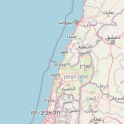
Map view of Mount Carmel National Park

Use this park location map to pinpoint Mount Carmel National Park in Israel, understand its exact geographic position, and read its mapped placement within the surrounding landscape more clearly.

Pigeon | © OpenStreetMap contributors

Location context for Mount Carmel National Park

Haifa District
Park atlas

Map the regional protected landscapes and compare natural features across surrounding park geography.

Browse Related National Parks and Protected Areas Near Mount Carmel National Park
Continue your exploration from Mount Carmel National Park to discover other national parks and protected areas across the surrounding Mediterranean landscape. Compare diverse protected landscapes, trace their geographic distribution, and understand their regional context for deeper atlas-style park discovery.
National parkIsrael

Yehi'am Fortress National Park: National Park with Protected Landscape Identity in Israel

Discover its mapped geographic boundaries and regional landscape context.

Yehi'am Fortress National Park is a key protected area situated within the geographic landscape of Israel. This national park entry provides structured insights into its distinct natural features and its role as a mapped protected zone. Explore the regional context and unique geographic identity of Yehi'am Fortress National Park, contributing to a broader understanding of Israel's conservation landscapes.

Relief
Upland
Access
Moderate access
Scope
Terrestrial
Water
No major water
National parkIsrael

Bar'am National Park: Preserving Ancient Jewish Heritage and Galilee Landscape

Explore significant Talmudic-era synagogues and borderland geography.

Bar'am National Park is an important archaeological site in Israel's upper Galilee, renowned for its remarkably preserved ancient Jewish synagogues dating to the Talmudic period. These structures represent significant tangible evidence of Jewish religious life and architectural styles from late antiquity. Situated amidst the rolling hills of the Galilee countryside, the park's landscape offers a unique combination of historical reflection and scenic views towards the Lebanese border, making it a key destination for understanding regional heritage and geography.

Relief
Upland
Access
Moderate access
Scope
Terrestrial
Water
No major water
Nature reserveLebanon

Tyre Coast Nature Reserve: Lebanon's Protected Nature Reserve Geography and Atlas Mapping

Discover the mapped natural landscape and regional context.

Tyre Coast Nature Reserve represents a distinct protected area within Lebanon, offering a unique focus for geographic exploration. This entry provides detailed insights into its mapped boundaries, situating it within the broader natural landscape and regional geography of the country. Engage with the structured atlas data to understand the specific protected land identity and geographic characteristics of this nature reserve.

Area
3.8 km²
Established
1998
Relief
Lowland
Climate
Mediterranean
National parkIsrael

Yarkon-Tel Afek National Park: Explore Its Protected Landscape and Israeli Geography

Mapped protected area and natural terrain context.

Gain a structured understanding of Yarkon-Tel Afek National Park, a designated national park within Israel. This detail entry focuses on its geographic identity and role as a protected landscape, providing essential context for atlas exploration. Understand the park's mapped boundaries and its contribution to the natural geography of the region without extraneous visitor details.

Scope
Terrestrial
Water
Minor water
Nature reserveAjloun Governorate

Ajloun Forest Reserve: A Protected Mediterranean Woodland in Jordan's Ajloun Governorate

Explore the unique protected landscape and mapped terrain of Ajloun Forest Reserve.

Ajloun Forest Reserve is a nature reserve located in Jordan's Ajloun Governorate, distinguished by its rare Mediterranean woodland ecosystem. This protected area provides crucial habitat and showcases a landscape of rolling hills and valleys, offering a stark contrast to the country's predominantly arid regions. Its designation as a UNESCO biosphere reserve underscores its importance for conservation, including efforts in roe deer restoration and the preservation of the black iris, Jordan's national flower. Discover the geographic context and protected nature of this significant Jordanian landscape.

Area
13 km²
Established
1988
IUCN
IV
Relief
Highland
National parkIsrael

Castel National Park: A National Park for Geographic Discovery in Israel

Investigate the mapped protected landscape and regional terrain.

Castel National Park represents a key protected area within Israel, focusing on the discovery of its mapped terrain and geographic identity. As a national park, it serves as a crucial entity for understanding regional conservation landscapes and the distribution of protected areas across Israel. This detailed view allows for focused exploration of the park's boundaries and its contribution to the country's natural heritage, offering valuable context for atlas-based geographical inquiry.

Relief
Mountain
Climate
Mediterranean
Scope
Terrestrial
Water
No major water
Nature reserveLebanon

Al Shouf Cedar Nature Reserve: A Protected Landscape in Lebanon's Geography

Explore its mapped natural terrain and protected boundaries.

Investigate Al Shouf Cedar Nature Reserve, a protected natural area situated within Lebanon. This page offers a detailed view of its protected landscape identity and geographic context, crucial for understanding its placement within the region's natural atlas. Examine the mapped terrain and park boundaries that distinguish this significant nature reserve.

Area
550 km²
Established
1996
Relief
Mountain
Climate
Temperate
Watercolor painting of rolling hills with pink, green, and purple hues
National parkIsrael

Ashkelon National Park: Ancient Coastal Protected Landscape and Archaeological Atlas

Explore mapped ruins, Fatimid walls, and Mediterranean coastal geography.

Ashkelon National Park in Israel offers a unique dive into ancient urban development, preserving layers of history from multiple civilizations along the Mediterranean coast. This protected area features landmark archaeological discoveries, including the Middle Bronze Age gate and extensive Roman ruins, all situated within a distinct coastal landscape. Understanding its mapped boundaries and the progression of its terrain provides critical context for appreciating this significant heritage site's geographic and historical importance.

IUCN
V
Relief
Lowland
Climate
Mediterranean
Access
Access unknown

Common questions about visiting, size, designation, and location context for Mount Carmel National Park

Mount Carmel National Park FAQs for park facts, access, geography, and protected area context
Find quick answers about Mount Carmel National Park, including protected-area facts, park geography, trail and visitor context, and how the park fits into its surrounding country and regional landscape.
MoriAtlas Explorer

Continue Your Protected Areas Search Across the Global Atlas

Deepen your exploration by continuing the structured search for national parks and protected areas worldwide. Utilize the comprehensive filtering capabilities to compare different conservation landscapes and refine your understanding of global park geography. Discover more about the distribution and characteristics of protected natural areas.

Global natural geography