Mori Atlas logo
National parkMu Ko Phetra National Park

Discover mapped boundaries and regional atlas details for this protected national park.

Mu Ko Phetra National Park: Thailand's Protected Landscape and Geographic Context

Mu Ko Phetra National Park represents a significant protected natural area within Thailand, offering a unique geographic identity for exploration. This entry provides an atlas-centric view, detailing the park's mapped boundaries and its placement within the broader landscape context of Southeast Asia. Understanding its location and protected status is key to appreciating its role in the region's natural geography.

Marine National ParkIsland ArchipelagoCoral ReefsLimestone IslandsMarine TurtlesBird Nests

Mu Ko Phetra National Park

National park

Park overview

Structured park overview, official facts, and landscape profile for Mu Ko Phetra National Park

Mu Ko Phetra National Park park facts, protected area profile, and essential visitor context
Review the core facts for Mu Ko Phetra National Park, including designation, size, terrain, visitor scale, habitats, and operating context in one park-focused overview.

About Mu Ko Phetra National Park

Mu Ko Phetra National Park represents one of Thailand's significant marine conservation areas, protecting a diverse collection of islands, reefs, and marine environments in the Strait of Malacca off the country's southern peninsula. The park's geography is characterized by a scattered archipelago extending across both Trang and Satun provinces, with the majority of its area consisting of open water rather than land. This marine-centric character makes it distinctive among Thailand's protected areas, as the park's ecological significance lies beneath the surface as much as above it. The islands within the park vary considerably in character, from small rocky outcrops used by fishermen as temporary refuges during the fishing season to larger islands featuring substantial beach formations and limestone cliff systems. Ko Khao Yai, the largest island, contains Ao Kam Poo bay, a 700-meter wide inlet featuring a waterfall and stream that empties directly onto a beach used by nesting turtles. The park's location along a major maritime corridor gives it both ecological importance and sensitivity to maritime traffic and development pressures. The proposed Pak Bara deepwater seaport in the nearby La-ngu District represents a potential threat to the park's continued integrity, as increased maritime activity and coastal development could impact the marine environments the park was established to protect.

Quick facts and research context for Mu Ko Phetra National Park

Mu Ko Phetra National Park is located in Trang and Satun provinces along Thailand's Andaman Sea coast. The park covers 494 square kilometers, with open water comprising 94.74 percent of the total area. It was established in 1984 as Thailand's 49th national park. The two largest islands are Ko Phetra and Ko Khao Yai. The park recorded approximately 130,000 visitors in 2019. Several islands contain bird nest concessions where swiftlets nest in cliff caves, and multiple beaches serve as turtle egg-laying sites.

Park context

Deeper park guide and search-rich context for Mu Ko Phetra National Park

Mu Ko Phetra National Park history, landscape, wildlife, and travel context
Explore Mu Ko Phetra National Park through its history, landscape character, ecosystems, wildlife, conservation priorities, cultural context, and seasonal travel timing in a structured park guide built for atlas discovery and search intent.

Why Mu Ko Phetra National Park stands out

Mu Ko Phetra is best known for its extensive marine ecosystem protection spanning a chain of approximately 30 islands in the Strait of Malacca. The park is particularly recognized for its rich coral reef formations that surround many of the islands, providing habitat for diverse marine life. Several islands function as significant marine turtle nesting sites, with beaches serving as protected egg-laying locations. The park's limestone island formations, especially the dramatic castle-like rocks on Ko Khao Yai and the oddly shaped cliffs of Ko Phetra, are visually striking features. The swiftlet nest harvesting tradition on certain islands represents a unique cultural and economic practice, with nests collected from high cliff caves and valued in the bird's nest trade.

Mu Ko Phetra National Park history and protected-area timeline

Mu Ko Phetra National Park was established on December 31, 1984, becoming the 49th national park in Thailand and the 14th marine national park within the country's protected area system. The establishment reflected Thailand's growing commitment to marine conservation during the 1980s, a period when the country began expanding its network of marine protected areas to safeguard coastal and offshore ecosystems. The park's creation recognized the ecological significance of the island chain and surrounding marine environment in the Strait of Malacca, an area with substantial biodiversity and traditional fishing use. Since its designation, the park has operated under the management of Thailand's Department of National Parks, Wildlife and Plant Conservation, which oversees protection, visitor management, and conservation programs. The park has maintained its marine focus while also addressing the terrestrial components of the islands, including the limestone formations, beaches, and cave systems that support specialized species. The tradition of bird nest collection from island cliffs predates the park's establishment and continues under concession arrangements, representing a historical use pattern that has been integrated into the park's management framework.

Mu Ko Phetra National Park landscape and geographic character

The landscape of Mu Ko Phetra National Park is defined by its marine environment and island formations, with limestone geology creating the most distinctive visual features. The islands scattered across the park display characteristic steep limestone cliffs that rise abruptly from the sea, often topped with vegetation and containing cave systems in their upper reaches. Most islands feature relatively small beaches due to the steep nature of the coastline, though several support more substantial sandy areas. The two largest islands, Ko Phetra and Ko Khao Yai, showcase the park's most dramatic terrain. Ko Phetra is noted for its oddly shaped cliffs that give the island a distinctive profile, while Ko Khao Yai features castle-like limestone formations and the sheltered Ao Kam Poo bay with its freshwater input from a waterfall and stream. The park includes the mainland Rawai Beach, a 3.5-kilometer stretch on the Trang Province coast that serves as a popular camping location and provides visitor access to the island park. The underwater landscape features extensive coral reef formations in the shallow waters surrounding many islands, creating a contrasting marine terrain to the rugged above-water limestone scenery.

Mu Ko Phetra National Park ecosystems, habitats, and plant life

The nature of Mu Ko Phetra centers on its marine ecosystems, which constitute the overwhelming majority of the park's protected area. The open water environments support diverse pelagic and reef-associated species, while the coral reef systems around islands provide critical habitat for numerous fish species, invertebrates, and other marine organisms. The park's islands support terrestrial vegetation adapted to the limestone terrain, with vegetation zones ranging from beach strand vegetation through coastal scrub to forest on the higher slopes of larger islands. The cave systems within island cliffs support specialized fauna adapted to dark environments, with swiftlets being the most notable inhabitants due to their economically valuable nests. The marine turtle nesting beaches represent a particularly significant ecological feature, as these sites support the continuation of turtle populations in the region. The mix of island types within the park, from bare rock outcrops to larger forested islands, creates habitat diversity that supports different species assemblages across the archipelago.

Mu Ko Phetra National Park wildlife and species highlights

Wildlife in Mu Ko Phetra National Park spans both marine and terrestrial environments, with marine turtles being among the most significant faunal components. Several islands within the park serve as nesting sites where female turtles come ashore to deposit eggs in the sandy beaches, particularly on the shores of Ao Kam Poo bay on Ko Khao Yai. The surrounding waters support marine turtles as well as diverse fish communities associated with the coral reef systems. Birdlife includes the swiftlets that nest in the high caves of island cliffs, with certain islands having been placed under concession for decades to harvest the valuable bird nests. These nest collection activities require specialized access and are managed through permitting systems. The islands support various bird species adapted to coastal and island environments, while the surrounding waters attract seabirds and migratory species. The terrestrial wildlife on larger islands includes species adapted to limestone forest habitats, though the park's wildlife focus emphasizes the marine environment given the predominantly oceanic character of the protected area.

Mu Ko Phetra National Park conservation status and protection priorities

Mu Ko Phetra National Park serves as an important marine conservation area protecting reef systems, island ecosystems, and critical marine turtle nesting sites in Thailand's southern waters. The park's designation reflects recognition that the archipelago and its surrounding marine environment contain ecological values requiring formal protection. The coral reefs around multiple islands represent biodiversity hotspots that benefit from the protected status, which limits potentially damaging activities within park boundaries. Marine turtle nesting beaches receive protection that helps ensure the continued survival of turtle populations in the Strait of Malacca region. However, the park faces ongoing conservation challenges from proposed development in the surrounding area, particularly the Pak Bara deepwater seaport project. Increased maritime traffic and coastal development associated with such infrastructure could impact water quality, marine habitats, and the overall ecological integrity that the park was established to protect. The park's management must balance conservation objectives with sustainable visitation and traditional uses that have historical roots in the local marine environment.

Mu Ko Phetra National Park cultural meaning and human context

The cultural context of Mu Ko Phetra National Park reflects the maritime traditions of both Thai and Malay communities in the southern peninsula region. The park's name originates from Malay, with "Phetra" derived from "Pulau Petra" meaning the island of Petra, indicating the historical Malay influence on the area's toponymy. Several islands have both Thai and Malay names, reflecting the cultural overlap between the two communities in this border region near the provincial boundary between Trang and Satun. The bird nest collection tradition represents a historical economic activity that predates park establishment and continues under concession arrangements, with collectors accessing high cliff caves to harvest swiftlet nests that are highly valued in regional markets. Islands have historically served as temporary refuges for fishermen during the fishing season, a traditional use pattern that continues today. The park's islands are not permanently inhabited, but the surrounding waters and coastlines support communities whose livelihoods are intertwined with the marine environment that the park protects.

Top sights and standout views in Mu Ko Phetra National Park

Mu Ko Phetra National Park offers distinctive marine and island experiences within a protected framework. The park's approximately 30 islands provide diverse exploration opportunities, from the dramatic limestone cliffs of Ko Khao Yai to the nesting turtle beaches of Ao Kam Poo bay. Coral reef diving and snorkeling around islands such as Ko Phetra and Ko Bulon reveal underwater environments protected from more intensive use. The park's status as a marine national park distinguishes it from Thailand's more numerous mountain and forest parks, offering a different conservation and recreation paradigm centered on island and marine environments. The swiftlet nest concession islands represent a unique aspect, though access for nest collection is controlled and not generally available to regular visitors. The mainland Rawai Beach provides accessible coastal recreation and camping opportunities for visitors preferring to experience the park from the mainland rather than island-hopping.

Best time to visit Mu Ko Phetra National Park

Mu Ko Phetra National Park can be visited throughout the year, though the optimal period generally corresponds to the dry season from November through April when conditions are most favorable for marine activities and island exploration. During these months, sea conditions tend to be calmer and visibility for diving and snorkeling around coral reefs is typically better than during the wet season. The monsoon season from May through October brings increased rainfall and sometimes rougher sea conditions that may affect boat access to more remote islands and reduce underwater visibility. However, the park remains accessible year-round, and the wet season may offer different experiences for visitors seeking fewer crowds. Water temperature remains warm throughout the year given the tropical location, allowing for comfortable marine activities in any season. Visitors interested in marine turtle nesting should be aware that nesting occurs at different times depending on species, with peak periods varying across the year.

Park location guide

Geography guide, regional context, and park location map for Mu Ko Phetra National Park

Mu Ko Phetra National Park park geography, regions, and map view in Thailand
Understand where Mu Ko Phetra National Park sits in Thailand through a broader geographic reading of the surrounding landscape, nearby location context, and its mapped position within the national park landscape.

How Mu Ko Phetra National Park fits into Thailand

Thailand is a Southeast Asian nation formerly called Siam, located in mainland Southeast Asia. It operates as a unitary parliamentary constitutional monarchy under King Vajiralongkorn. The country borders Myanmar, Laos, Cambodia, and Malaysia, with maritime boundaries involving Vietnam, Indonesia, and India. Thailand has a population of nearly 66 million and covers approximately 513,120 km². Historically, the Sukhothai Kingdom marks the beginning of Thai history, followed by the powerful Ayutthaya Kingdom.

Wider geography shaping Mu Ko Phetra National Park in Thailand

Thailand occupies mainland Southeast Asia with borders to Myanmar (west/northwest), Laos (east/northeast), Cambodia (southeast), and Malaysia (south). The country has coastline along the Gulf of Thailand to the southeast and the Andaman Sea to the southwest. The territory covers approximately 513,120 km².

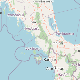
Map view of Mu Ko Phetra National Park

Use this park location map to pinpoint Mu Ko Phetra National Park in Thailand, understand its exact geographic position, and read its mapped placement within the surrounding landscape more clearly.

Pigeon | © OpenStreetMap contributors

Location context for Mu Ko Phetra National Park

Satun ProvinceTrang Province
Park atlas

Explore related marine ecosystems and limestone island landscapes across the southern Thai coast.

Discover Other National Parks and Protected Areas Near Mu Ko Phetra National Park, Thailand
Continue your discovery of Thailand's protected areas by exploring other marine national parks and island archipelagos geographically close to Mu Ko Phetra National Park in the Strait of Malacca. Compare distinctive limestone formations, coral reef ecosystems, and vital marine turtle nesting sites within this captivating southern Thai coastal region.
National parkSatun Province

Tarutao National Park: National Park Exploration and Geographic Context in Satun Province

Mapped boundaries and regional landscape details await discovery.

Tarutao National Park stands as a protected national park entity, offering a specific focal point for exploring Thailand's natural landscapes within Satun Province. This page provides access to its protected-area identity and geographic mapping, essential for understanding its placement within the broader regional atlas. Investigate the park's distinct landscape features and its contribution to the protected areas of the Andaman Sea coast.

Area
1,490 km²
Established
1974
IUCN
II
Visitors
238.4K annual
National parkTrang Province

Hat Chao Mai National Park: National Park Protected Landscape and Geographic Context

Explore Trang Province's mapped protected areas and natural terrain.

Hat Chao Mai National Park serves as a focal point for understanding protected lands in Trang Province, Thailand. This entry offers insights into the park's specific geographic attributes and its designation as a national park. Users can explore the mapped boundaries and the surrounding regional geography, gaining a clear picture of this protected landscape within the MoriAtlas geographic framework. Understanding Hat Chao Mai National Park provides essential context for regional park exploration and mapped conservation areas.

Area
231 km²
Established
1981
IUCN
II
Visitors
83K annual
Stylized illustration of a forested area featuring a waterfall, large leaves, and a winding path
National parkSatun Province

Thale Ban National Park: Mapped Protected Landscape and Unique Wetland Ecosystem in Satun Province

Explore karst and granite mountains, natural lake geography, and diverse biodiversity.

Thale Ban National Park offers a fascinating study in protected landscape geography, centered around a rare natural lake formed by geological damming. This national park in Satun Province, Thailand, showcases a striking contrast between ancient limestone karst formations and younger granite mountains, contributing to its unique biodiversity and ecosystems. Its position near the Malaysian border highlights its role in regional conservation, making it a key site for understanding mapped terrain and protected natural areas.

Area
196 km²
Established
1980
IUCN
II
Visitors
12K annual
National parkThailand

Mu Ko Lanta National Park: Protected National Park and Mapped Landscape in Thailand

Explore its boundaries within Thailand's regional geography.

Mu Ko Lanta National Park is a significant protected area within Thailand, defined by its national park status and distinct geographic features. This page facilitates structured discovery of its mapped landscape and the regional context it occupies. Users can explore its protected-area identity and understand how it fits into the broader atlas of natural landscapes in Southeast Asia, emphasizing geographic specificity and atlas-driven insights.

Area
134 km²
Established
1990
IUCN
II
Visitors
217.4K annual
National parkThailand

Khao Pu, Khao Ya National Park: Explore Protected Boundaries and Thailand Geography

A key national park for understanding regional landscape context.

Khao Pu, Khao Ya National Park stands as a vital protected area in Thailand, offering rich geographic details for atlas exploration. This page details its specific mapped boundaries and its identity as a national park, providing essential context for understanding natural landscapes within Southeast Asia. Users can gain insights into its regional significance and its contribution to the country's protected land network.

Area
694 km²
Established
1982
IUCN
II
Visitors
167.3K annual
National parkSongkhla Province

Khao Nam Khang National Park: National Park, Mapped Boundaries, and Regional Geography

Explore protected landscape identity and atlas context.

Gain detailed insights into Khao Nam Khang National Park, a key protected area situated within Songkhla Province. This national park serves as a critical reference point for understanding regional geography, its specific mapped boundaries, and its role as a conservation landscape. Discover its unique geographic context, vital for comprehensive atlas exploration of Thailand's natural heritage.

Area
212 km²
Established
1990
IUCN
II
Visitors
1.8K annual
National parkKrabi Province

Hat Noppharat Thara, Mu Ko Phi Phi National Park: Protected Landscape and Geographic Identity

Explore mapped terrain and protected natural areas in Krabi Province.

Hat Noppharat Thara, Mu Ko Phi Phi National Park stands as a distinct protected natural landscape, offering a unique geographic perspective within Krabi Province. This page delves into its role as a national park, highlighting its mapped boundaries and contribution to the regional atlas. Users can explore the park's specific natural terrain and understand its significance as a conservation area, providing a foundation for broader geographic discovery.

Area
388 km²
Established
1983
IUCN
II
Visitors
1.1M annual
National parkKrabi Province

Khao Phanom Bencha National Park: Protected Mountainous Rainforest and Waterfall Landscapes

Explore Krabi Province's unique protected area and its dramatic geographic features.

Khao Phanom Bencha National Park represents a core protected landscape within Krabi Province, Thailand. Dominated by the imposing Khao Phanom Bencha mountain range, its terrain includes steep, forested slopes and intricate valley systems that give rise to impressive waterfalls. This national park is an essential component of the region's protected natural areas, offering a detailed look at its unique ecosystem and geographic character through mapped landscape context and atlas exploration.

Area
50 km²
Established
1981
IUCN
II
Visitors
17.3K annual

Common questions about visiting, size, designation, and location context for Mu Ko Phetra National Park

Mu Ko Phetra National Park FAQs for park facts, access, geography, and protected area context
Find quick answers about Mu Ko Phetra National Park, including protected-area facts, park geography, trail and visitor context, and how the park fits into its surrounding country and regional landscape.
MoriAtlas Explorer

Continue Your Protected Areas Search Across the Global Atlas

Deepen your exploration by continuing the structured search for national parks and protected areas worldwide. Utilize the comprehensive filtering capabilities to compare different conservation landscapes and refine your understanding of global park geography. Discover more about the distribution and characteristics of protected natural areas.

Global natural geography