

Mori Atlas logo
National parkMurree-Kotli Sattian-Kahuta National Park

A rugged ecological corridor protecting chir pine forests and critical watershed catchments

Murree-Kotli Sattian-Kahuta National Park in the Himalayan Foothills of Punjab Pakistan

(Murree–Kotli Sattian–Kahuta National Park)

Murree-Kotli Sattian-Kahuta National Park spans 47,350 hectares of forested hill country within the Pothohar Plateau. This protected area connects the Margalla Hills to the western Himalayan foothills, creating a continuous wildlife corridor and safeguarding the headwaters of the Soan and Jhelum river systems. Its terrain ranges from mid-elevation valleys to ridges above 2,000 metres, supporting diverse chir pine and oak forest ecosystems.

national parkIUCN Category IIwestern Himalayan foothillsPothohar Plateauchir pine forestpine-oak forest

Murree-Kotli Sattian-Kahuta National Park

National park

Park overview

Structured park overview, official facts, and landscape profile for Murree-Kotli Sattian-Kahuta National Park

Murree-Kotli Sattian-Kahuta National Park park facts, protected area profile, and essential visitor context

Review the core facts for Murree-Kotli Sattian-Kahuta National Park, including designation, size, terrain, visitor scale, habitats, and operating context in one park-focused overview.

About Murree-Kotli Sattian-Kahuta National Park

Murree-Kotli Sattian-Kahuta National Park is one of the newest national parks in Pakistan, created in 2020 as part of a national push to expand formal protection over the country's ecologically important landscapes. It occupies a strategic position in northeastern Punjab, where the hill ranges around the hill station of Murree meet the broader Pothohar Plateau and extend eastward toward Azad Jammu and Kashmir.

Designated as an IUCN Category II national park, the park covers a large peri-urban forested belt that sits between two of Pakistan's better-known protected areas: Margalla Hills National Park, which surrounds parts of Islamabad, and Pir Lasura National Park in Azad Jammu and Kashmir. By knitting these landscapes together, the park helps maintain habitat continuity for species that move across administrative and ecological boundaries.

Ecologically, the park lies within the Himalayan subtropical pine forests ecoregion. Chir pine is the dominant tree, accompanied by grey oak, Acacia modesta, Dodonaea viscosa, and a rich understorey of scrub and grasses. Its topography is steep and dissected, with deep valleys giving way to higher ridges near Murree and Patriata, where cooler conditions support more temperate forest elements. This mix of elevations and vegetation types creates layered habitats that support a wide range of mammals and birds.

From a human perspective, the park also encompasses landscapes that have long been visited for their scenery, religious sites, and hill-station appeal. Today it falls under the management of the Punjab Wildlife and Parks Department through its Rawalpindi Wildlife Division, with a focus on habitat conservation, community engagement, and eco-tourism. Its declaration aligns Pakistan's protected-area network with international commitments under the Convention on Biological Diversity and supports national afforestation initiatives such as the Billion Tree Tsunami programme.

Quick facts and research context for Murree-Kotli Sattian-Kahuta National Park

Murree-Kotli Sattian-Kahuta National Park lies in northeastern Rawalpindi District, Punjab Province, Pakistan, with Murree as its nearest major town. It was formally notified in November 2020 by the Punjab Wildlife and Parks Department under Section 17 of the Punjab Wildlife Act of 1974, and is classified as an IUCN Category II national park.

The park spans the hill ranges of Murree, Kotli Sattian, and Kahuta within the western Himalayan foothills of the Pothohar Plateau, with elevations rising from around mid-elevation valleys to higher ridges near Patriata and Murree. It forms a landscape-level corridor between Margalla Hills National Park and Pir Lasura National Park, and contributes to watershed protection for the Soan and Jhelum river systems.

Protection and recognition

Documented terrestrial protection scope and international recognition data

Murree-Kotli Sattian-Kahuta National Park Protection Status and Designation

Murree-Kotli Sattian-Kahuta National Park maintains a documented terrestrial protection scope within its regional conservation framework. Official records compile available designation details, management parameters, and international recognition sources for this protected area.

Protection details

Protection scope
Terrestrial
Transboundary protection
No
Park context

Deeper park guide and search-rich context for Murree-Kotli Sattian-Kahuta National Park

Murree-Kotli Sattian-Kahuta National Park history, landscape, wildlife, and travel context

Explore Murree-Kotli Sattian-Kahuta National Park through its history, landscape character, ecosystems, wildlife, conservation priorities, cultural context, and seasonal travel timing in a structured park guide built for atlas discovery and search intent.

Why Murree-Kotli Sattian-Kahuta National Park stands out

The park is especially known for its position as a newly designed ecological corridor linking Margalla Hills National Park with Pir Lasura National Park across the Pothohar Plateau. It anchors chir pine and pine-oak forest habitat in the western Himalayan foothills and provides landscape continuity for wide-ranging species such as the common leopard and several Himalayan pheasants. Equally important is its watershed role: the park's forests and catchments regulate flows into the Soan and Jhelum rivers, which supply drinking water and irrigation for Rawalpindi and Islamabad. This combination of biodiversity, corridor function, and water security gives the park a significance that extends well beyond its recent establishment.

Murree-Kotli Sattian-Kahuta National Park history and protected-area timeline

Murree-Kotli Sattian-Kahuta National Park was formally created through a notification issued on 21 November 2020 by the Punjab Wildlife and Parks Department under Section 17 of the Punjab Wildlife (Protection, Preservation, Conservation and Management) Act, 1974. It emerged from the Protected Areas Initiative launched by the Government of Pakistan, which aimed to expand and reorganize the country's network of formally protected landscapes.

The park was conceived and declared alongside other new Pothohar-region protected areas, including Tilla Reserve National Park and Kheri Murat National Park. Together, these designations marked a concerted effort to strengthen landscape-level conservation across the Rawalpindi plateau and its surrounding hill systems.

A formal gazette notification issued by the Government of Punjab in 2023 clarified the park's boundaries and confirmed its total area at just over 47,000 hectares. Since establishment, the park has been managed through the Rawalpindi Wildlife Division, which oversees enforcement, habitat monitoring, and the gradual introduction of community-based conservation and controlled eco-tourism activities under the provincial eco-tourism policy.

Murree-Kotli Sattian-Kahuta National Park landscape and geographic character

The park occupies a band of forested hill country in the western Himalayan foothills, forming part of the larger Pothohar Plateau system. Its terrain is shaped by long ridges and deeply incised valleys, with elevation rising from roughly 500 to 800 metres in the southern and lower sections to peaks exceeding 2,000 metres near Patriata and the upper Murree hills.

This varied relief creates layered landscapes: warmer, drier lower slopes supporting broadleaf scrub and acacia woodland, and cooler, moister middle and upper slopes clothed in chir pine and mixed pine-oak forest. Steep drainage lines run down toward the Jhelum River on one side and the Soan River system on the other, giving the park an extensive network of seasonal and perennial streams.

The combination of high ridges, deep valleys, and forested slopes produces a landscape that feels both rugged and densely vegetated. Open vistas from the higher elevations contrast with the enclosed, shadowy character of the forested valleys below, and the overall setting gives the park a strong sense of topographic continuity with both Margalla Hills and Pir Lasura.

Murree-Kotli Sattian-Kahuta National Park ecosystems, habitats, and plant life

Ecologically, the park falls within the Himalayan subtropical pine forests ecoregion, a vegetation zone that runs along the lower and middle elevations of the western Himalayas. Its vegetation is dominated by chir pine, with grey oak forming an important secondary layer and species such as Acacia modesta and Dodonaea viscosa occupying drier slopes and disturbed margins. A diverse scrub and grass layer fills the understorey, contributing to the habitat's structural complexity.

The steep environmental gradients from low to high elevation support a transition between subtropical and more temperate forest character. On lower slopes, more xeric and broadleaf elements prevail, while cooler ridges and northern aspects support denser pine and oak stands. Riparian belts along streams add yet another habitat dimension, with denser green cover and distinctive plant communities lining the watercourses.

Because the park sits within a corridor of forested hills, it not only preserves these habitats in their own right but also helps maintain ecological processes across the broader Pothohar region, including seed dispersal, wildlife movement, and forest regeneration across elevation zones.

Murree-Kotli Sattian-Kahuta National Park wildlife and species highlights

The park supports a mix of mammals typical of the western Himalayan foothills, including the common leopard, which is reportedly the area's apex predator. Other recorded mammals include the rhesus macaque, Asiatic jackal, Indian pangolin, red fox, and various small cats and civets. These species together reflect the park's role in providing habitat for both wider-ranging carnivores and smaller, more cryptic mammals that depend on forest cover and rocky terrain.

The birdlife is particularly notable. Forest-dwelling pheasants such as the Himalayan monal, kalij pheasant, and koklass pheasant are present, giving the park strong significance for pheasant conservation. In addition, broader avifaunal communities occur, including migratory species that move seasonally between lower elevation wetlands such as Rawal Lake and the higher Himalayan valleys.

The combination of forest interior, edge habitat, and riparian corridors supports a layered wildlife community. Large predators, primates, ground-dwelling birds, and a range of smaller mammals and reptiles share the landscape, reinforcing the park's biodiversity value and its role as a stepping stone between the Margalla Hills and Pir Lasura.

Murree-Kotli Sattian-Kahuta National Park conservation status and protection priorities

Conservations significance at Murree-Kotli Sattian-Kahuta National Park is anchored in its role as a major ecological corridor. As a Category II national park, it provides strict protection for a large block of western Himalayan foothill habitat, but its importance is amplified by its position between Margalla Hills National Park to the west and Pir Lasura National Park in Azad Jammu and Kashmir to the east. This positioning supports landscape connectivity for species such as leopards and pheasants that need extensive, unbroken habitat to maintain viable populations.

The park's catchments also deliver tangible ecosystem services, regulating water flow and reducing soil erosion for the Soan and Jhelum river systems that supply Rawalpindi and Islamabad. By protecting these forested watersheds, the park contributes directly to downstream water security and flood mitigation.

At a national policy level, the park supports Pakistan's commitments under the Convention on Biological Diversity and aligns with large-scale afforestation and restoration efforts such as the Billion Tree Tsunami programme. The 2022 IUCN assessment also identified it as part of a broader corridor strengthening conservation outcomes across Punjab, Islamabad, and Azad Jammu and Kashmir.

Top sights and standout views in Murree-Kotli Sattian-Kahuta National Park

Among the park's standout features is its function as an ecological bridge between Margalla Hills National Park and Pir Lasura National Park, making it a cornerstone of landscape-level conservation in the Pothohar region. Its elevation range, from mid-elevation valleys to peaks above 2,000 metres, produces layered forest habitats dominated by chir pine and pine-oak woodland, with rich pheasant and mammal communities.

Equally distinctive is its watershed role. The park's forests feed the Soan and Jhelum river systems, which sustain Rawalpindi and Islamabad, giving the protected area a direct link between biodiversity conservation and urban water security.

Best time to visit Murree-Kotli Sattian-Kahuta National Park

The park's elevation range and forested character mean that seasons shape the visitor experience considerably. Spring and early summer typically bring fresh foliage, active birdlife, and pleasant conditions on the mid-elevation trails, making it a good time for wildlife observation and hiking through pine and oak woodland.

Late summer monsoon conditions can make slopes slippery and visibility limited, but they also recharge streams and forest vegetation. Autumn tends to offer clearer skies and stable weather, while winter brings colder conditions and occasional snowfall at the higher elevations around Murree and Patriata, transforming the landscape but limiting access on steeper routes. Travellers interested primarily in pheasants and forest birdlife often favor spring and autumn windows when activity is high and conditions remain comfortable across most of the park.

Monthly climate preview

Long-term temperature ranges and monthly precipitation averages for representative terrain

Murree-Kotli Sattian-Kahuta National Park Climate Normals and Annual Weather Patterns

Representative coordinate measurements reveal annual temperature rhythms and monthly precipitation patterns across the protected landscape. Examining the full twelve-month climate profile provides detailed historical baseline data for analytical comparisons.
Annual mean15 °C
3 °C25 °C
Jan
Feb
Mar10°
Apr16°
May21°
Jun25°
Jul24°
Aug22°
Sep20°
Oct15°
Nov10°
Dec
Warmest month
June

24.6 °C

Coolest month
January

3.5 °C

Wettest month
July

4.8 mm/day

Driest month
November

0.8 mm/day

Park location guide

Geography guide, regional context, and park location map for Murree-Kotli Sattian-Kahuta National Park

Murree-Kotli Sattian-Kahuta National Park park geography, regions, and map view in Pakistan

Understand where Murree-Kotli Sattian-Kahuta National Park sits in Pakistan through a broader geographic reading of the surrounding landscape, nearby location context, and its mapped position within the national park landscape.

How Murree-Kotli Sattian-Kahuta National Park fits into Pakistan

Pakistan, officially the Islamic Republic of Pakistan, is a federal parliamentary Islamic republic in South Asia. It is the fifth-most populous country and the 33rd-largest by area. The country gained independence from British India in 1947 and has a diverse history spanning ancient civilizations including Mehrgarh and the Indus Valley Civilisation. Pakistan shares maritime borders with Oman and is bounded by the Arabian Sea, Gulf of Oman, and several neighboring countries.

Wider geography shaping Murree-Kotli Sattian-Kahuta National Park in Pakistan

Pakistan is located in South Asia, bordered by the Arabian Sea to the south, the Gulf of Oman to the southwest, and shares land borders with India to the east, Afghanistan to the west, Iran to the southwest, and China to the northeast. The country also shares a maritime border with Oman in the Gulf of Oman. The Wakhan Corridor in Afghanistan separates Pakistan from Tajikistan in the northwest.

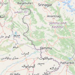
Map view of Murree-Kotli Sattian-Kahuta National Park

Use this park location map to pinpoint Murree-Kotli Sattian-Kahuta National Park in Pakistan, understand its exact geographic position, and read its mapped placement within the surrounding landscape more clearly.

Pigeon | © OpenStreetMap contributors

Location context for Murree-Kotli Sattian-Kahuta National Park

Punjab
Park atlas

Discover connected hill forests, ecological corridors, and regional protected landscapes across the Pothohar Plateau.

Explore Nearby National Parks and Protected Areas Around Murree-Kotli Sattian-Kahuta National Park

Browse adjacent national parks and protected areas sharing the rugged terrain and forested ridge networks of the western Himalayan foothills. Comparing these regional conservation landscapes reveals broader ecological continuity across the Pothohar Plateau.
National parkIslamabad Capital Territory
About 25 km away#1 closest

West

Margalla Hills National Park: Pakistan's Gateway to Himalayan Foothills Geography

Mapped protected landscape with rich Sino-Himalayan biodiversity.

Margalla Hills National Park, situated in the Islamabad Capital Territory, serves as Pakistan's most accessible national park and a vital entry point to the Himalayan foothills. This protected landscape is defined by its rugged mountain terrain, ranging from lower scrublands to higher pine and oak woodlands, with elevations up to 1,604 meters. The park's geological significance, with ancient marine fossil formations, adds a unique dimension to its natural identity. Discover the mapped boundaries and ecological richness that characterize this important protected area, offering insights into regional geography and diverse habitats.

Area
173.86 km²
Established
1980
IUCN
V
Relief
Mountain
National parkKhyber Pakhtunkhwa
About 32 km away#2 closest

Northwest

Ayubia National Park: Protected Area Identity and Mountainous Terrain

Discover its mapped geography within Khyber Pakhtunkhwa

Ayubia National Park stands as a key protected landscape within the Himalayan foothills of Khyber Pakhtunkhwa, Pakistan. Its designation as a national park signifies its role in conserving unique temperate coniferous and mixed forests across steep mountainous terrain. This page details the park's geographic setting, its mapped boundaries, and the natural features that define its protected status, offering a structured view for atlas-driven exploration of Pakistan's natural heritage.

Area
33.12 km²
Established
1984
IUCN
V
Visitors
250K annual
National parkAzad Kashmir
About 43 km away#3 closest

Northeast

Panjal Mastan National Park: High-Altitude Plateau Landscape in Azad Kashmir

Discover mapped terrain and protected area geography.

Panjal Mastan National Park represents a significant protected landscape within the Pir Panjal mountain range of Azad Kashmir, Pakistan. This national park is characterized by its expansive high-altitude plateau, sitting at an average elevation of 2,800 meters, offering a unique regional geography. Known for its dramatic mountainous surroundings and seasonal wildflower meadows that bloom in spring, the park provides valuable context for understanding the natural terrain and protected area distribution in this part of the western Himalayas.

Area
300 km²
IUCN
II
Relief
Mountain
Climate
Alpine
National parkAzad Jammu and Kashmir
About 48 km away#4 closest

Southeast

Poonch River Mahaseer National Park: Pakistan's First Riverine Conservation Area

Mapped aquatic landscape and freshwater biodiversity in Azad Jammu and Kashmir.

Poonch River Mahaseer National Park is a significant aquatic protected area established in 2010, renowned for being Pakistan's first dedicated riverine conservation zone. Situated along the Poonch River in Azad Jammu and Kashmir, it spans approximately 22.5 square kilometers, encompassing the main river channel and key tributary nullahs crucial for breeding. The park's primary objective is to protect the endangered golden mahseer and the broader freshwater ecosystem, serving as a vital model for river-based conservation and mapped biodiversity stewardship in the region.

Area
22.5 km²
Established
2010
IUCN
II
National parkPunjab
About 68 km away#5 closest

Southwest

Kheri Murat National Park: Protected Scrub Forest and Wildlife Conservation in Punjab

Explore the mapped terrain and protected landscape context.

Discover Kheri Murat National Park, a recent national park designation located in Punjab, Pakistan, situated on the rolling hills of the Kala Chitta Range. This protected area features a distinct subtropical thorn scrub forest ecosystem, providing essential habitat for wildlife, including the Punjab urial, and serving as a critical site for bird conservation. Its unique landscape offers valuable insights into regional geography and the preservation of natural wilderness within a predominantly agricultural province, making it a noteworthy entity for atlas exploration.

Area
35.37 km²
Established
2020
IUCN
II
Relief
Mountain
National parkBaramulla district
About 71 km away#6 closest

Northeast

Kazinag National Park: Protected Area Geography and Mapped Boundaries in Baramulla District

Explore the regional landscape and terrain of this national park.

Kazinag National Park represents a distinct protected area within India's Baramulla district. This entry provides structured geographic information, focusing on the park's mapped boundaries and its role as a national park. Users can explore its landscape context and understand its specific regional terrain, contributing to a comprehensive atlas view of protected lands.

Area
160 km²
Established
1992
IUCN
II
Relief
Mountain
National parkAzad Jammu and Kashmir
About 77 km away#7 closest

Southeast

Pir Lasura National Park: Pakistan National Park with Subtropical Pine Forest Landscape

Explore the mapped boundaries and geography of this unique Azad Jammu and Kashmir protected area.

Pir Lasura National Park in Azad Jammu and Kashmir, Pakistan, is a critical national park encompassing approximately 15.8 square kilometers of subtropical chir pine forest and scrub vegetation. Located in the Pir Lasura mountain range, it features a varied terrain with elevations ranging from 1,000 to 2,000 meters, contributing to its unique ecosystem at the transitional zone between major geographic regions. This page offers a detailed atlas-style exploration of the park's mapped features, its importance as a protected landscape, and its role in supporting diverse wildlife including significant vulture roosting sites and common leopard habitats.

Area
15.8 km²
Established
2005
IUCN
II
Relief
Mountain
National parkAzad Jammu and Kashmir
About 86 km away#8 closest

North

Machiara National Park: A Protected National Park in Pakistan's Himalayas

Explore mapped terrain and mountain biodiversity.

Machiara National Park, located in Azad Jammu and Kashmir, Pakistan, is a designated national park preserving unique Himalayan ecosystems. This atlas-focused exploration details the park's protected landscape, encompassing steep slopes, forested ridges, and varied terrain. Discover its significance for wildlife conservation and its position within the broader regional geography, offering a clear view of its mapped natural features.

Area
135.33 km²
Established
1996
IUCN
II
Relief
Mountain

Common questions about visiting, size, designation, and location context for Murree-Kotli Sattian-Kahuta National Park

Murree-Kotli Sattian-Kahuta National Park FAQs for park facts, access, geography, and protected area context

Find quick answers about Murree-Kotli Sattian-Kahuta National Park, including protected-area facts, park geography, trail and visitor context, and how the park fits into its surrounding country and regional landscape.
MoriAtlas Explorer

Continue Your Protected Areas Search Across the Global Atlas

Deepen your exploration by continuing the structured search for national parks and protected areas worldwide. Utilize the comprehensive filtering capabilities to compare different conservation landscapes and refine your understanding of global park geography. Discover more about the distribution and characteristics of protected natural areas.

Global natural geography