Mori Atlas logo
Protected areaNabq Protected Area

Trace the protected boundaries and mapped terrain of this key natural area in Egypt.

Nabq Protected Area: South Sinai Governorate Protected Landscape Geography and Atlas Exploration

(Nabq Managed Resource Protected Area)

Nabq Protected Area represents a significant protected landscape within Egypt's South Sinai Governorate. This page provides an atlas-focused view of its geographic identity, allowing for exploration of its mapped boundaries and regional context. Understand how this protected area fits into the broader landscape of South Sinai and serves as a distinct point of geographic discovery within the natural atlas.

Coastal Protected AreaMarine EcosystemsRed SeaCoral ReefsMangrove ForestsSinai Desert

Nabq Protected Area

Protected area

Park overview

Structured park overview, official facts, and landscape profile for Nabq Protected Area

Nabq Protected Area park facts, protected area profile, and essential visitor context
Review the core facts for Nabq Protected Area, including designation, size, terrain, visitor scale, habitats, and operating context in one park-focused overview.

About Nabq Protected Area

Nabq Protected Area stands as one of Egypt's most significant coastal-marine reserves, encompassing a remarkable diversity of habitats within a relatively compact area along the Gulf of Aqaba. The protected area was established in 1992 under Prime Ministerial Decree 1511 and later expanded in 1996 to incorporate the Dahab marine section, creating what is now formally known as the Nabq Managed Resource Protected Area. The reserve occupies a strategic position in South Sinai, near the major tourist hub of Sharm el-Sheikh, while maintaining its ecological integrity as a wilderness area. The management framework operates through the Protected Area Management Unit, which falls within the Sinai Protected Area Network under the Central Department of Protected Areas at Egypt's Environment Affairs Agency. The reserve's IUCN Category VI designation reflects its approach to sustainable use, aiming to conserve biological diversity while providing sustainable flow of natural products and services to meet community needs. This management philosophy recognizes the area's ecological value while acknowledging the traditional Bedouin communities who inhabit the region and depend on its resources.

Quick facts and research context for Nabq Protected Area

Nabq Protected Area covers 600 square kilometers along Egypt's Red Sea coast in South Sinai, established in 1992 and expanded in 1996 to include marine sections near Dahab. The reserve features the Gulf ofAqaba coastline with its exceptional coral reef systems hosting 208 species of hard coral and 438 fish species. It contains Egypt's most significant mangrove stand, a 4.5-kilometer fringe of Avicennia marina representing the northernmost extension of this ecosystem in the Red Sea and Indian Ocean. The interior encompasses the Wadi El Keed watershed, one of the largest drainage basins flowing to the Gulf of Aqaba on the Egyptian side. More than twenty globally threatened species have been recorded within the reserve, including marine turtles, dugong, Nubian ibex, and dorcas gazelle.

Park context

Deeper park guide and search-rich context for Nabq Protected Area

Nabq Protected Area history, landscape, wildlife, and travel context
Explore Nabq Protected Area through its history, landscape character, ecosystems, wildlife, conservation priorities, cultural context, and seasonal travel timing in a structured park guide built for atlas discovery and search intent.

Why Nabq Protected Area stands out

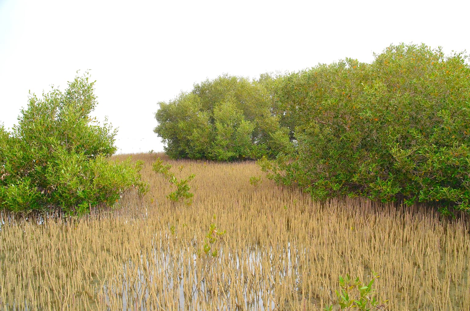
Nabq Protected Area is best known for its remarkable combination of marine and terrestrial ecosystems in a compact geographic setting. The coral reefs along its Gulf of Aqaba coastline are among the most diverse in the Egyptian Red Sea, supporting 208 hard coral species and 438 fish species. The reserve contains Egypt's most extensive mangrove forest, a 4.5-kilometer semi-continuous stand of Avicennia marina that represents the extreme northern limit of this ecosystem in the entire Red Sea-Indian Ocean system. The interior mountain wadis, particularly Wadi El Keed, support exceptional biodiversity including endangered Nubian ibex and dorcas gazelle populations. The area also features the distinctive Arak Sand Dunes with Salvadora persica vegetation, a unique landscape feature within the region.

Mangrove vegetation with tall reeds and trees in a coastal wetland area
Avicennia marina, also known as sea mangrove, a type of mangrove found in the Red Sea, photographed in Nabq Protected Area, South Sinai.

Nabq Protected Area history and protected-area timeline

Nabq Protected Area was established in 1992 through Prime Ministerial Decree 1511, creating a protected area focused on the terrestrial and coastal ecosystems of South Sinai along the Gulf of Aqaba. The initial designation reflected growing recognition of the region's ecological significance and the need to manage its natural resources sustainably. In 1996, the protected area was significantly expanded through Decree 33, which added the Dahab marine section as a Dahab Environmentally Managed Area, creating the comprehensive protected area now known as Nabq Managed Resource Protected Area. This expansion acknowledged the ecological continuity between the terrestrial wadi systems and the marine coastal environments, as well as the importance of coral reef ecosystems to the region's biodiversity and economy. The management structure evolved to include the Protected Area Management Unit, operating within the Sinai Protected Area Network and reporting to the Nature Conservation Sector through the central department in Cairo. Local Bedouin communities, particularly the El Mezina Tribe, have maintained their presence in the area throughout the protected area's history, continuing traditional practices of fishing, pastoralism, and increasingly, sustainable tourism.

Nabq Protected Area landscape and geographic character

The landscape of Nabq Protected Area encompasses a remarkable range of environments within its 600-square-kilometer expanse along Egypt's Red Sea coast. The coastal zone features the pristine shoreline of the Gulf of Aqaba, where crystal-clear waters meet rocky and sandy shores. The marine environment supports extensive coral reef systems that rank among the most diverse in the Red Sea, with reef formations visible from the surface down to deeper waters. Moving inland, the terrain rises sharply into the granite and sandstone mountains characteristic of central Sinai, dissected by dramatic wadis that channel seasonal flash floods toward the coast. Wadi El Keed represents the largest drainage basin flowing to the Gulf of Aqaba on the Egyptian side, containing substantial vegetation and serving as a critical wildlife corridor. The interior also features the distinctive Arak Sand Dunes, where Salvadora persica bushes create an unusual vegetation pattern atop sand deposits. The contrast between the marine coastal plain and the rugged mountain interior creates a visually striking landscape that defines the protected area's character.

Nabq Protected Area ecosystems, habitats, and plant life

The ecological character of Nabq Protected Area is defined by its exceptional habitat diversity, representing a complete terrestrial-marine ecosystem within a uniquely compact setting along the Gulf of Aqaba. The marine component features coral reefs that are among the best and most diverse in the Egyptian Red Sea, supporting 208 species of hard coral alongside 438 fish species and numerous marine invertebrates. These reef systems form the foundation of the reserve's marine biodiversity and hold enormous economic value for regional tourism. The mangrove forests represent a particularly significant ecological feature, with a 4.5-kilometer semi-continuous fringe of Avicennia marina constituting the extreme northern extension of this ecosystem in the Red Sea and Indian Ocean system. These mangroves form critical nurseries for economically important fish species and provide nesting habitat for numerous waterbird species. Substantial seagrass beds in the coastal waters support threatened species including green sea turtles and dugong. The terrestrial environment features desert mountain habitats, wadi systems with more developed vegetation, and the unique Arak Sand Dunes, creating ecological gradients from coastal to interior environments.

Nabq Protected Area wildlife and species highlights

Nabq Protected Area supports remarkable wildlife diversity across both marine and terrestrial environments, with more than twenty globally threatened species known to occur within its boundaries. The marine environment provides habitat for significant populations of marine turtles, including green sea turtles that forage on the extensive seagrass beds, as well as various shark species. The dugong, a threatened marine mammal, relies on the coastal seagrass communities. The bird population includes notable species such as the osprey and the white-eyed gull, which nest in the coastal and mangrove areas. The terrestrial fauna features several endangered species adapted to the desert mountain environment, including the Nubian ibex navigating the rocky wadi walls and the dorcas gazelle traversing the arid plains. The wadi systems support diverse invertebrate communities and provide crucial water sources for wildlife during the dry seasons. The mangrove forests function as nurseries for numerous fish species, contributing to the marine food web and supporting both ecological and commercial importance.

Nabq Protected Area conservation status and protection priorities

Nabq Protected Area holds significant conservation importance at both national and international scales, recognized through its IUCN Category VI designation as a Managed Resource Protected Area. The reserve protects Egypt's most extensive and significant mangrove ecosystem, representing the northernmost extension of this habitat type in the Red Sea-Indian Ocean system and providing critical ecological functions for marine and terrestrial species. The coral reef systems, among the most diverse in Egyptian waters, require active protection given the pressures from tourism development, fishing, and climate change affecting Red Sea marine environments. More than twenty globally threatened species rely on the protected area's habitats, including marine turtles, dugong, and terrestrial species such as Nubian ibex and dorcas gazelle. The management framework emphasizes sustainable use and community involvement, balancing conservation objectives with the needs of the local Bedouin population. The Protected Area Management Unit operates under Egypt's environmental laws to control development, enforce protection measures, and promote conservation while supporting sustainable tourism and local livelihoods.

Nabq Protected Area cultural meaning and human context

Nabq Protected Area is home to the Bedouin El Mezina Tribe, whose traditional lifestyle remains closely connected to the land and sea of the Sinai peninsula. The Bedouin communities have inhabited this region for generations, practicing fishing, pastoralism, and more recently, sustainable tourism activities that work within the protected area framework. Their traditional knowledge of the landscape, seasonal movements, and natural resources contributes to the cultural fabric of the protected area. The area contains archaeological sites, including locations in Wadi Saialet Dalal where evidence of historic Bedouin presence has been documented. The integration of traditional Bedouin practices with modern conservation management represents an important aspect of the reserve's approach, acknowledging that local communities are integral to the landscape's ongoing story. Tourism activities in the area increasingly focus on ecotourism that provides economic benefits to the local community while encouraging appreciation of the natural and cultural heritage.

Top sights and standout views in Nabq Protected Area

Nabq Protected Area offers exceptional highlights spanning marine and terrestrial environments. The coral reef diving and snorkeling opportunities along the Gulf of Aqaba coastline reveal vibrant underwater ecosystems with exceptional species diversity. The mangrove forests at the reserve's coastal fringe represent a unique ecological feature, being the northernmost mangroves in the Red Sea system and providing striking visual contrast between the green vegetation and desert backdrop. The interior mountain wadis, particularly Wadi El Keed, provide wilderness trekking opportunities through pristine desert landscapes where Nubian ibex can be observed on cliff faces. The Arak Sand Dunes present a distinctive landscape feature with their unusual vegetation pattern. The presence of endangered species including dugong and green sea turtles in the coastal waters adds to the reserve's conservation significance. Combined with Bedouin cultural experiences and proximity to Sharm el-Sheikh, the protected area serves as a model of integrated conservation and sustainable tourism in Egypt's Red Sea region.

Best time to visit Nabq Protected Area

The optimal time to visit Nabq Protected Area aligns with the cooler months from October through April, when daytime temperatures are more comfortable for outdoor exploration and marine activities. During this period, water temperatures in the Gulf of Aqaba remain pleasant for snorkeling and diving, typically ranging from 21 to 26 degrees Celsius. The summer months from May to September bring higher temperatures that can make terrestrial exploration challenging, though the marine environment remains accessible and the underwater visibility often improves. Wildlife viewing opportunities are year-round, though animal activity concentrates around water sources during the hotter months. The reserve can be visited throughout the year, with each season offering different experiences, from spring flowering in the wadis to winter bird migrations. Given the protected area's proximity to Sharm el-Sheikh, visitors can combine beach and marine activities with wilderness exploration inland, making the area accessible for both day trips and extended stays.

Park location guide

Geography guide, regional context, and park location map for Nabq Protected Area

Nabq Protected Area park geography, regions, and map view in Egypt
Understand where Nabq Protected Area sits in Egypt through a broader geographic reading of the surrounding landscape, nearby location context, and its mapped position within the national park landscape.

How Nabq Protected Area fits into Egypt

Egypt is a transcontinental country bridging Northeast Africa and Southwest Asia via the Sinai Peninsula. With over 107 million inhabitants, it is the most populous country in the Arab world and third-most populous in Africa. The country features a rich historical heritage dating back to ancient civilizations along the Nile Delta, with Cairo as its capital and largest city.

Wider geography shaping Nabq Protected Area in Egypt

Egypt occupies a strategic position in Northeast Africa, extending into Southwest Asia through the Sinai Peninsula. It is bordered by the Mediterranean Sea to the north, Palestine and Israel to the northeast, the Red Sea to the east, Sudan to the south, and Libya to the west. The Gulf of Aqaba in the northeast separates Egypt from Jordan and Saudi Arabia. The country features the Nile Delta and Valley as its main fertile region, surrounded by desert terrain.

Map view of Nabq Protected Area

Use this park location map to pinpoint Nabq Protected Area in Egypt, understand its exact geographic position, and read its mapped placement within the surrounding landscape more clearly.

Pigeon | © OpenStreetMap contributors

Location context for Nabq Protected Area

South Sinai Governorate

Explore the unique marine habitats, extensive mangrove forests, and rugged desert terrain defining this Egyptian protected area.

Nabq Protected Area: Visual Exploration of Egypt's Red Sea Coastal and Desert Landscapes
Browse photographs revealing the distinctive coastal and desert landscapes of Nabq Protected Area, providing visual context for its remarkable Red Sea coral reefs, critical mangrove forests, and rugged mountain wadis. These curated views offer valuable insights into the park's diverse habitats and unique protected-area character, enhancing understanding of its complex marine and terrestrial ecosystems.

Mangrove vegetation with tall reeds and trees in a coastal wetland area

Park atlas

Compare the diverse marine, coastal, and desert protected landscapes spanning Egypt's South Sinai region, from vibrant coral reefs to rugged mountain wadis.

Discover Other Protected Areas Near Nabq Protected Area, Exploring Red Sea Coastal and Sinai Desert Landscapes
Explore other significant protected areas geographically connected to Nabq Protected Area, tracing the regional distribution of coastal marine ecosystems, extensive mangrove forests, and rugged Sinai desert landscapes. Comparing these park profiles offers deeper insights into the varied conservation efforts and distinct natural features preserved across Egypt's Red Sea territories and inland mountain wadis.
National parkSouth Sinai Governorate

Ras Muhammad National Park: South Sinai Protected Landscape and Geographic Atlas

Discover the mapped boundaries of this Egyptian national park.

Ras Muhammad National Park is a crucial protected area within the South Sinai Governorate, offering insights into Egypt's natural landscapes. This page facilitates an atlas-style exploration of the park, highlighting its geographic significance and protected status. Users can investigate its mapped terrain and understand its context within the regional geography of the Sinai Peninsula for structured geographic discovery.

Area
480 km²
Established
1983
Relief
Mixed relief
Climate
Arid
National park

Makhtesh Ramon National Park: Israel's Premier Erosion Cirque & Geological Wonder

Discover dramatic desert terrain and ancient, colorful rock formations.

Makhtesh Ramon National Park in Israel's Negev Desert is the world's largest erosion cirque, a vast 40-kilometer depression revealing millions of years of geological history. Its striking landscape features colorful clay hills, ancient volcanic remnants, fossil beds, and unique sandstone formations, making it an unparalleled destination for understanding Earth's past through its protected natural terrain. Explore the mapped boundaries and regional context of this extraordinary desert formation.

Relief
Mountain
Climate
Arid
Access
Moderate access
Scope
Terrestrial
Watercolor illustration of a canyon with winding river, mountains, and rolling hills
National parkIsrael

Ein Avdat National Park: A Spectular Desert Oasis and Protected Landscape in Israel

Explore its unique springs, waterfalls, and ancient Nabatean and Byzantine history.

Ein Avdat National Park showcases a rare desert oasis environment, a starkly beautiful protected landscape where natural springs emerge from the Negev's arid terrain. This park is celebrated for its dramatic waterfalls, deep pools, and the preserved remnants of ancient human habitation, including a remarkable Byzantine cave monastery carved directly into the canyon walls. Its geography, shaped by the Nahal Zin wadi, provides a vivid study in desert ecosystems and their capacity for supporting life and history over millennia, making it a key site for understanding landscape context in Israel.

Area
4.8 km²
IUCN
V
Relief
Mixed relief
Climate
Arid
Watercolor illustration of a mountainous landscape with multiple colored terrain layers
Biosphere reserveJordan

Dana Biosphere Reserve: Mapped Biosphere Reserve in Jordan's Geography

Explore protected landscape boundaries and regional context.

Dana Biosphere Reserve is a critical protected landscape in Jordan, recognized for its significant geographic features and ecological value. This page offers detailed insights into its mapped boundaries and its place within the broader regional geography of the Middle East. It serves as an essential resource for understanding the park's protected-area identity and its contribution to Jordan's natural heritage, facilitating a deeper atlas-driven exploration of its terrain and conservation significance.

Area
308 km²
Established
1989
Relief
Mixed relief
Scope
Terrestrial
Watercolor illustration showing a winding river through green hills with distant trees under a light sky
National park

Eshkol National Park: Desert Wetland Oasis with Archaeological Significance in Southern Israel

Mapped protected area featuring Ein HaBesor spring and Besor valley landscapes.

Eshkol National Park showcases a rare desert wetland environment sustained by the significant Ein HaBesor spring in Israel's Northern Negev. This protected natural area offers a distinctive landscape where water nourishes lush vegetation against the backdrop of arid terrain. Beyond its ecological value, the park encompasses archaeological remnants, including the mound of Khirbet Shalala, providing a rich geographical and historical discovery context within the Besor Stream basin.

Area
3.54 km²
Relief
Lowland
Climate
Arid
Access
Easy access
Nature reserveJordan

Wadi Mujib Nature Reserve: Explore Jordan's Dramatic Canyon Protected Landscape

Discover mapped boundaries and arid biodiversity within this unique rift valley gorge.

Wadi Mujib Nature Reserve represents a significant protected landscape in Jordan, celebrated for its deep desert canyon and dramatic slot canyon terrain. Situated in the Dead Sea region, this reserve protects a remarkable range of geography, from its lowest points near the Dead Sea to surrounding mountain terrain. Its status as a UNESCO biosphere reserve highlights its importance for arid biodiversity and its role as a migratory bird flyway, offering a distinct atlas-level discovery of Jordan's natural heritage.

Area
212 km²
Established
1987
IUCN
IV
Relief
Mountain
Watercolor painting of rolling hills with pink, green, and purple hues
National parkIsrael

Ashkelon National Park: Ancient Coastal Protected Landscape and Archaeological Atlas

Explore mapped ruins, Fatimid walls, and Mediterranean coastal geography.

Ashkelon National Park in Israel offers a unique dive into ancient urban development, preserving layers of history from multiple civilizations along the Mediterranean coast. This protected area features landmark archaeological discoveries, including the Middle Bronze Age gate and extensive Roman ruins, all situated within a distinct coastal landscape. Understanding its mapped boundaries and the progression of its terrain provides critical context for appreciating this significant heritage site's geographic and historical importance.

IUCN
V
Relief
Lowland
Climate
Mediterranean
Access
Access unknown
National parkIsrael

Castel National Park: A National Park for Geographic Discovery in Israel

Investigate the mapped protected landscape and regional terrain.

Castel National Park represents a key protected area within Israel, focusing on the discovery of its mapped terrain and geographic identity. As a national park, it serves as a crucial entity for understanding regional conservation landscapes and the distribution of protected areas across Israel. This detailed view allows for focused exploration of the park's boundaries and its contribution to the country's natural heritage, offering valuable context for atlas-based geographical inquiry.

Relief
Mountain
Climate
Mediterranean
Scope
Terrestrial
Water
No major water

Common questions about visiting, size, designation, and location context for Nabq Protected Area

Nabq Protected Area FAQs for park facts, access, geography, and protected area context
Find quick answers about Nabq Protected Area, including protected-area facts, park geography, trail and visitor context, and how the park fits into its surrounding country and regional landscape.
MoriAtlas Explorer

Continue Your Protected Areas Search Across the Global Atlas

Deepen your exploration by continuing the structured search for national parks and protected areas worldwide. Utilize the comprehensive filtering capabilities to compare different conservation landscapes and refine your understanding of global park geography. Discover more about the distribution and characteristics of protected natural areas.

Global natural geography