Mori Atlas logo
National parkNagarahole National Park

Discover the geographic contours and protected area context of Nagarahole National Park.

Nagarahole National Park: India's Mapped Protected Landscape in Karnataka

(Nagarahole Tiger Reserve)

Nagarahole National Park represents a significant protected landscape within the Indian state of Karnataka, offering a focal point for geographic exploration. This entry details the park's specific mapped boundaries and its place within the regional natural terrain, providing crucial context for understanding protected areas and their role in the landscape atlas.

Tiger ReserveElephant HabitatWestern GhatsBirdwatchingNational ParkDry Deciduous Forest

Nagarahole National Park

National park

Park overview

Structured park overview, official facts, and landscape profile for Nagarahole National Park

Nagarahole National Park park facts, protected area profile, and essential visitor context
Review the core facts for Nagarahole National Park, including designation, size, terrain, visitor scale, habitats, and operating context in one park-focused overview.

About Nagarahole National Park

Nagarahole National Park represents a significant conservation achievement in southern India's protected area network. The park's strategic location in the Western Ghats, one of the world's eight biodiversity hotspots, positions it as a crucial habitat for numerous species of flora and fauna. The park derives its name from the Kannada words 'nagara' meaning snake and 'hole' referring to streams, reflecting the area's serpentine watercourses and the historical presence of reptiles in the region. Beyond its ecological significance, the park serves as a critical corridor for elephant movement between the Western Ghats and other protected landscapes. The Kabini reservoir within the park not only provides vital water resources for wildlife but also creates scenic landscapes that attract visitors seeking to experience India's natural heritage. The park's management balances conservation objectives with limited tourism activities that support local economies while minimizing ecological impact.

Quick facts and research context for Nagarahole National Park

Nagarahole National Park covers 847.98 square kilometers in Karnataka, India, at elevations ranging from 687 to 960 meters above sea level. The park lies in the foothills of the Western Ghats, extending from the Brahmagiri hills southward toward Kerala. It is bordered by Bandipur National Park to the southeast, with the Kabini reservoir separating the two protected areas. Key water sources include the Lakshmana Tirtha River, Kabini River, numerous perennial and seasonal streams, and several natural and artificial water bodies. The park receives approximately 1,440 millimeters of annual rainfall and experiences a typical Indian monsoon climate with distinct wet and dry seasons.

Park context

Deeper park guide and search-rich context for Nagarahole National Park

Nagarahole National Park history, landscape, wildlife, and travel context
Explore Nagarahole National Park through its history, landscape character, ecosystems, wildlife, conservation priorities, cultural context, and seasonal travel timing in a structured park guide built for atlas discovery and search intent.

Why Nagarahole National Park stands out

Nagarahole National Park is best known as one of India's premier tiger reserves and elephant habitats within the Western Ghats biodiversity hotspot. The park supports significant populations of Bengal tigers, Indian elephants, and gaur, alongside diverse mammal communities including leopards, dholes, sambar deer, and chital. Its location within the Nilgiri Biosphere Reserve and adjacent positioning to Bandipur National Park makes it a critical conservation landscape in southern India. The park's dry deciduous and moist deciduous forests, combined with its network of rivers and reservoirs, create ideal conditions for wildlife viewing, particularly during the dry season when animals congregate around water sources.

Nagarahole National Park history and protected-area timeline

Nagarahole National Park has deep historical roots as an exclusive hunting reserve of the Wodeyar dynasty, the former rulers of the Kingdom of Mysore. The royal family used the area for game hunting for generations before independence transformed the region's conservation trajectory. In 1955, the area was formally established as a wildlife sanctuary, marking the first step toward systematic protection. The sanctuary was upgraded to national park status in 1983, providing stronger legal protection under India's national park framework. A significant milestone came in 2003 when the park was declared India's 37th tiger reserve, integrating it into the Project Tiger conservation initiative. The reserve expanded its boundaries over time, growing from 643.39 square kilometers in 2003 to the current 847.98 square kilometers in 2012. This expansion reflected growing recognition of the importance of maintaining viable wildlife habitats and ecological corridors.

Nagarahole National Park landscape and geographic character

The landscape of Nagarahole National Park is characterized by undulating terrain in the foothills of the Western Ghats, with elevation varying from 687 to 960 meters above sea level. The park encompasses a mix of dry deciduous forest in the lower reaches and moist deciduous forest in higher areas, with the Brahmagiri hills forming the northwestern boundary. The terrain features numerous valleys, small hills, and natural drainage channels that create diverse microhabitats throughout the park. The Kabini River and its reservoir form a prominent landscape feature, providing permanent water sources and creating wetland habitats that support diverse wildlife. Other water bodies including the Lakshmana Tirtha River, Sarati Hole, Nagar Hole, Balle Halla, four perennial streams, 47 seasonal streams, four small perennial lakes, 41 artificial tanks, and several swamps dot the landscape, making water a consistent feature across different seasons.

Nagarahole National Park ecosystems, habitats, and plant life

The ecological character of Nagarahole National Park is defined by its position within the Western Ghats biodiversity hotspot and its integration into the Nilgiri Biosphere Reserve. The park's forests are predominantly dry deciduous and moist deciduous types, with tree species including teak, crocodile bark, Indian kino, axlewood, and clumping bamboo dominating different zones. The forest composition supports complex food webs and provides critical habitat for both forest-dependent species and edge species. Annual rainfall of approximately 1,440 millimeters sustains the ecosystem through a distinct monsoon season followed by a dry period that concentrates wildlife around remaining water sources. The park's ecological significance is amplified by its location as part of a larger conservation landscape that includes Bandipur National Park and other protected areas, facilitating wildlife movement and genetic exchange between populations.

Nagarahole National Park wildlife and species highlights

Nagarahole National Park supports remarkable mammalian diversity with major predators including Bengal tigers, Indian leopards, dholes, Indian jackals, and sloth bears. Large herbivores such as Indian elephants, gaur, sambar deer, chital, barking deer, four-horned antelope, and wild boar inhabit various forest and grassland habitats throughout the park. The arboreal mammal community includes gray langurs, bonnet macaques, red slender lorises, flying squirrels, and the striking Indian giant squirrel. Over 250 bird species have been recorded, making the park an Important Bird Area. Notable avian residents include the white-rumped vulture, lesser adjutant, greater spotted eagle, Nilgiri wood pigeon, and numerous endemic species such as the Malabar trogon, Malabar grey hornbill, and blue-winged parakeet. Reptiles include mugger crocodiles, various snakes, and Bengal monitors, while amphibians and diverse insect communities complete the park's biodiversity profile.

Nagarahole National Park conservation status and protection priorities

Nagarahole National Park faces several conservation challenges despite its protected status. Historical threats have included illegal logging, particularly of sandalwood and teak, with timber smuggling remaining a concern in some areas. Poaching of both mammals and birds has been documented, with studies indicating that hunting posed significant threats to wildlife populations in the late 1990s and early 2000s. Elephant mortality from poaching for ivory has been particularly concerning, with nearly 100 elephants dying between 1991 and 2005 in the surrounding forest divisions. A major forest fire in January 2012 destroyed over 6,000 acres of forest, highlighting vulnerability to seasonal fires and drought conditions. Conservation efforts have included tribal relocation programs aimed at reducing human-wildlife conflict and pressure on tiger and elephant habitats, though these initiatives have faced resistance from affected communities.

Nagarahole National Park cultural meaning and human context

The Jenu Kuruba people are the primary indigenous inhabitants historically associated with the forest areas of Nagarahole. Their traditional lifestyle centered on food gathering, honey collection, and forest resource use, with 'Jenu' meaning honey in Kannada and 'Kuruba' relating to shepherd communities. The community has faced increasing restrictions on entering the national park as conservation priorities intensified. Relocation efforts have been ongoing since 2000, with displaced families provided land and housing at peripheral villages. In May 2025, approximately 50 Jenu Kuruba families returned to their ancestral village within the reserve, decades after eviction, highlighting ongoing tensions between conservation objectives and tribal rights. The cultural context reflects broader challenges in Indian conservation involving the displacement of forest-dwelling communities in favor of wildlife protection.

Top sights and standout views in Nagarahole National Park

Nagarahole National Park stands out as one of the highest density tiger habitats in India, with the added attraction of substantial elephant populations and diverse birdlife exceeding 250 species. The Kabini reservoir offers unique wildlife viewing opportunities where visitors can observe elephants, crocodiles, and waterfowl from boat safaris. The park's integration into the Nilgiri Biosphere Reserve and proximity to Bandipur National Park create extensive conservation landscape benefits. The Western Ghats setting provides scenic beauty with rolling hills, valleys, and forest-covered landscapes that change dramatically between wet and dry seasons. The park's history as a royal hunting ground of the Wodeyar dynasty adds historical depth to the natural experience.

Best time to visit Nagarahole National Park

The optimal time to visit Nagarahole National Park is during the dry season from October through May, when wildlife becomes more concentrated around available water sources and is easier to spot. The period from November to February offers pleasant temperatures and comfortable conditions for game viewing, while March through May brings hotter conditions that push animals increasingly toward waterholes and the Kabini reservoir, often resulting in excellent sighting opportunities. The monsoon season from June to September brings heavy rainfall that makes most of the park inaccessible and obscures wildlife visibility, though the lush green landscapes and waterfalls provide scenic appeal for those who can visit during this period. Early morning and late afternoon game drives offer the best opportunities for observing tigers, elephants, and other wildlife.
Park location guide

Geography guide, regional context, and park location map for Nagarahole National Park

Nagarahole National Park park geography, regions, and map view in India
Understand where Nagarahole National Park sits in India through a broader geographic reading of the surrounding landscape, nearby location context, and its mapped position within the national park landscape.

How Nagarahole National Park fits into India

India is a South Asian country bordered by the Indian Ocean, Arabian Sea, and Bay of Bengal. It shares land borders with Pakistan, China, Nepal, Bhutan, Bangladesh, and Myanmar. The country has a population of over 1.4 billion people and operates as a federal parliamentary republic with its capital in New Delhi.

Wider geography shaping Nagarahole National Park in India

India occupies the Indian subcontinent in South Asia, bordered by the Arabian Sea to the southwest, the Bay of Bengal to the southeast, and the Indian Ocean to the south. It shares land borders with Pakistan to the west, China, Nepal, and Bhutan to the north, and Bangladesh and Myanmar to the east. The territory also includes the Andaman and Nicobar Islands in the Indian Ocean.

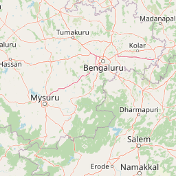
Map view of Nagarahole National Park

Use this park location map to pinpoint Nagarahole National Park in India, understand its exact geographic position, and read its mapped placement within the surrounding landscape more clearly.

Pigeon | © OpenStreetMap contributors

Location context for Nagarahole National Park

KarnatakaKodagu districtMysore district
Park atlas

Trace contiguous conservation landscapes and compare national park geography within the Western Ghats region surrounding Nagarahole National Park.

Discover National Parks and Protected Areas Near Nagarahole National Park
Continue your exploration from Nagarahole National Park by browsing other national parks and protected areas across the Western Ghats, including its contiguous partner Bandipur National Park. This geographic overview provides valuable context for comparing diverse conservation landscapes and understanding their regional spread and unique ecosystems.
Watercolor painting showing green fields, pink and yellow areas, and distant mountains
National parkNilgiri District

Mudumalai National Park: National Park Identity and Geographic Context in Nilgiri District

Mapped protected area and natural terrain details for this key Indian park.

Delve into the specific geographic identity of Mudumalai National Park, a protected national park situated in the Nilgiri District. This detail page provides access to its mapped natural landscape, helping users understand its protected boundaries and regional geographic significance. It serves as a foundational point for exploring the park's unique terrain within India's atlas of natural protected areas.

Area
321 km²
Established
1940
IUCN
II
Relief
Mountain
National parkKarnataka

Bandipur National Park: Karnataka's Protected Landscape and National Park Atlas Entry

Discover mapped terrain and diverse forest ecosystems in South India.

Bandipur National Park, a prominent national park within Karnataka, serves as a vital hub for understanding protected area geography and landscape diversity. Its ecological significance is amplified by its location at the intersection of the Deccan Plateau and the Western Ghats, supporting a unique blend of forest types and rich biodiversity. This entry provides essential context for atlas-based discovery, detailing the park's mapped terrain, its role as a tiger reserve, and its contribution to the Nilgiri Biosphere Reserve's conservation landscape.

Area
1,456.3 km²
Established
1973
IUCN
II
Relief
Mixed relief
National parkNilgiri District

Mukurthi National Park: Nilgiri District's Protected Montane Grassland and Shola Ecosystem

Explore a vital refuge for the endangered Nilgiri tahr.

Mukurthi National Park, situated in the Nilgiri District of India, is an essential protected area celebrated for its distinctive montane landscape. This national park plays a critical role in the survival of the endangered Nilgiri tahr, protecting the rare shola-grassland ecosystem where they thrive. Its dramatic terrain, high elevations, and unique ecological associations make it a focal point for understanding conservation geography and the mapped boundaries of protected lands within the Western Ghats.

Area
78.46 km²
Established
1990
IUCN
II
Relief
Mountain
Watercolor illustration of green hills, a river, and distant pink mountains
National parkKerala

Silent Valley National Park: Kerala's Protected Landscape and Geographic Atlas

Explore mapped boundaries and regional terrain in South India.

Silent Valley National Park stands as a key protected area within Kerala, India, offering rich insights into its geographic setting. This destination provides an atlas-driven view of the park's mapped boundaries, its integration with the surrounding regional geography, and the character of its natural landscapes. Users can engage with detailed information designed for structured exploration of protected natural areas and their mapped contexts.

Area
89.52 km²
Established
1984
IUCN
II
Relief
Mountain
Watercolor painting showing a landscape with rolling hills, forests, and distant mountains
National parkKarnataka

Kudremukh National Park: Karnataka's Protected Landscape and River Origin

Explore the geography of shola forests and grasslands.

Kudremukh National Park is a pivotal protected landscape in Karnataka, India, recognized for its distinctive montane grasslands and shola forests. This national park is a critical source for three major rivers: the Tunga, Bhadra, and Nethravathi, highlighting its ecological and geographic significance within the Western Ghats. The park's terrain features rolling hills and steep western slopes, contributing to its unique biodiversity and landscape character for atlas-based discovery.

Area
600.57 km²
Established
1987
IUCN
II
Relief
Mountain
Watercolor illustration showing mountains, a winding river, and green vegetation
National parkKarnataka

Bannerghatta National Park: A National Park in Karnataka with Mapped Geographic Identity

Explore the protected landscape and regional terrain context.

Bannerghatta National Park is an important protected area within the state of Karnataka, India. Its designation as a national park signifies its role in preserving regional natural landscapes and providing valuable geographic context for atlas exploration. Users can examine its mapped boundaries and understand its placement within the diverse terrain characteristic of South India and the Western Ghats, contributing to a structured understanding of protected lands.

Area
260.51 km²
Established
1974
IUCN
II
Relief
Mountain
National parkKerala

Eravikulam National Park: National Park with Mapped Protected Boundaries in Kerala

Understanding its geographic setting and landscape identity.

Delve into the protected landscape of Eravikulam National Park, a significant national park located in Kerala. This detailed entry focuses on its geographic coordinates, mapped boundaries, and its role as a distinct protected area within the regional geography. It serves as a valuable resource for exploring the park's natural terrain and its importance in conservation landscapes.

Area
97 km²
Established
1978
IUCN
II
Visitors
148.4K annual
National parkIdukki

Mathikettan Shola National Park: National Park Exploration and Geographic Mapping

Discover its protected landscape and regional context.

Mathikettan Shola National Park, a designated national park in the Idukki region, offers a focal point for understanding protected landscapes and their geographic distribution. This entry details the park's mapped boundaries and its specific setting within the regional geography, providing an atlas-level view of its conservation value. Users can explore the structured geographic identity of this protected natural area, enriching their understanding of India's park network.

Area
12.82 km²
Established
2003
IUCN
II
Relief
Mountain

Common questions about visiting, size, designation, and location context for Nagarahole National Park

Nagarahole National Park FAQs for park facts, access, geography, and protected area context
Find quick answers about Nagarahole National Park, including protected-area facts, park geography, trail and visitor context, and how the park fits into its surrounding country and regional landscape.
MoriAtlas Explorer

Continue Your Protected Areas Search Across the Global Atlas

Deepen your exploration by continuing the structured search for national parks and protected areas worldwide. Utilize the comprehensive filtering capabilities to compare different conservation landscapes and refine your understanding of global park geography. Discover more about the distribution and characteristics of protected natural areas.

Global natural geography