

Mori Atlas logo
Wildlife reserveNamibe Partial Reserve

Mapping the arid desert terrain, sand dune ecosystems, and protected habitat boundaries

Namibe Partial Reserve: A Comprehensive Geographic Atlas of Southwestern Angola Wildlife Reserves

(Reserva Parcial de Namibe)

Namibe Partial Reserve serves as a significant protected landscape within the Kaokoveld Desert of southwestern Angola. This wildlife reserve is defined by its vast mobile sand dunes, gravel plains, and unique botanical life, functioning as a vital component of cross-border conservation efforts. The area provides a stark geographic contrast to the surrounding regions, offering a focused look at the environmental character of the Namib-Kaokoveld arid zone.

desertarid landscapesand dunesKaokoveldWelwitschiatransfrontier conservation

Namibe Partial Reserve

Wildlife reserve

Park overview

Structured park overview, official facts, and landscape profile for Namibe Partial Reserve

Namibe Partial Reserve park facts, protected area profile, and essential visitor context

Review the core facts for Namibe Partial Reserve, including designation, size, terrain, visitor scale, habitats, and operating context in one park-focused overview.

About Namibe Partial Reserve

Namibe Partial Reserve occupies a striking position within the Kaokoveld Desert, one of the great arid landscapes of southwestern Africa. Stretching across roughly 4,450 square kilometres in Angola's Namibe Province, the reserve lies north of Iona National Park and is separated from it by a narrow inhabited corridor of land along the Curoca River. Together these two protected areas make up the Angolan portion of the Iona - Skeleton Coast Transfrontier Conservation Area, a cross-border initiative that connects Angola's desert parks with Namibia's Skeleton Coast region to the south.

The reserve's environment is uncompromisingly dry. Vast stretches of mobile sand dunes shape the topography, and the climate is too harsh for most conventional vegetation. Plant life here has evolved specifically to survive extreme aridity, intense solar radiation, and shifting sands, giving the area an unusually sparse but highly specialized flora. Among the species best adapted to these conditions is Welwitschia mirabilis, a botanical curiosity often described as a living fossil and one of the most photographed plants of the Namib-Kaokoveld region.

Classified as an IUCN Category IV protected area, Namibe Partial Reserve focuses on habitat and species management rather than strict wilderness preservation. Originally proclaimed in 1960 under Portuguese colonial administration, it remains part of the country's effort to safeguard the fragile desert ecosystems that extend across southwestern Angola. Though smaller in profile than the better-known Iona National Park, it contributes meaningfully to the ecological continuity of the larger transfrontier conservation landscape.

Quick facts and research context for Namibe Partial Reserve

Namibe Partial Reserve is located in Namibe Province in southwestern Angola, just inland from the Atlantic coast and adjacent to the city of Namibe. It is classified as IUCN Category IV, a habitat and species management area, and was first proclaimed in 1960 under Portuguese administration. The reserve covers roughly 4,450 square kilometres within the Kaokoveld Desert and is linked ecologically and institutionally to neighboring Iona National Park through the transfrontier conservation area that spans into Namibia's Skeleton Coast.

Protection and recognition

Documented terrestrial conservation scope and official recognition details

Namibe Partial Reserve Protection Status and Territorial Designation Records

Namibe Partial Reserve maintains a recorded terrestrial protection scope within the global conservation framework. Detailed administrative facts outline the established management perimeter and official recognition sources for this protected natural area.

Protection details

Protection scope
Terrestrial
Transboundary protection
No
Park context

Deeper park guide and search-rich context for Namibe Partial Reserve

Namibe Partial Reserve history, landscape, wildlife, and travel context

Explore Namibe Partial Reserve through its history, landscape character, ecosystems, wildlife, conservation priorities, cultural context, and seasonal travel timing in a structured park guide built for atlas discovery and search intent.

Why Namibe Partial Reserve stands out

Namibe Partial Reserve is especially known for its sweeping desert landscapes and its population of Welwitschia mirabilis, one of the most ancient and unusual plant species on Earth. Endemic to the Namib-Kaokoveld arid zone, this long-lived survivor rolls out two strap-like leaves across the sand over centuries, giving individual plants a tentacle-like, "desert octopus" appearance. The reserve is also recognized for its large sand dunes, which define the visual and ecological character of the protected area.

Namibe Partial Reserve history and protected-area timeline

Namibe Partial Reserve has its administrative origins in the late colonial period. It was proclaimed in 1960 by the authorities of Portuguese Angola, when southern Angola's arid landscapes were still administered under Portuguese rule. The reserve was originally established to protect the distinctive desert flora and fauna found in the Kaokoveld region north of present-day Iona National Park.

After Angola's independence, the area continued to function as a formally designated protected landscape, though its remote setting, conflict during the subsequent decades, and limited infrastructure reportedly affected its on-the-ground management. Its inclusion in the Iona - Skeleton Coast Transfrontier Conservation Area has given it a renewed regional conservation role, tying its fate to that of neighboring Iona National Park and to transboundary conservation initiatives linking Angola and Namibia.

Namibe Partial Reserve landscape and geographic character

The landscape of Namibe Partial Reserve is shaped by the harsh conditions of the Kaokoveld Desert. Large sand dunes dominate much of the visible terrain, forming shifting ridges and plains of pale, gritty sand that move slowly with the prevailing winds. These dunes are not only a defining visual feature but also a primary driver of the area's ecology, as they bury, expose, and reshape the substrate that plants and animals depend on.

Beyond the dunes, the reserve includes broader arid plains, gravel flats, and transitional zones that link it ecologically to Iona National Park and to the Skeleton Coast of Namibia. The Curoca River forms part of the southern boundary context, with its narrow corridor of more densely occupied land separating this reserve from Iona. Overall, the terrain is flat to gently undulating, with minimal relief and an overwhelming sense of openness that defines the visual character of southwestern Angola's desert interior.

Namibe Partial Reserve ecosystems, habitats, and plant life

The ecology of Namibe Partial Reserve reflects the extreme conditions of the Kaokoveld Desert. Plant communities here are sparse, widely spaced, and dominated by species adapted to prolonged drought, high temperatures, and shifting sandy substrates. Vegetation tends to be low-growing and long-lived, with individuals capable of surviving for centuries despite a scarcity of surface water.

The reserve is most famous ecologically for its population of Welwitschia mirabilis, an ancient gymnosperm endemic to the Namib-Kaokoveld arid zone. This species produces only two elongated leaves in its entire lifetime, which it wears down and tears over decades into curling, ribbon-like strips. Where Welwitschia occurs alongside other desert specialists, the vegetation assemblage is one of the most botanically distinctive in the world and a focal point for understanding desert adaptation in plants.

Namibe Partial Reserve wildlife and species highlights

Historically, Namibe Partial Reserve supported a range of arid-adapted mammals typical of the wider Kaokoveld region. Records from earlier decades mention elephant, greater kudu, oryx, black rhino, and Hartmann's mountain zebra as species that once roamed the area.

The current status of these populations, however, is uncertain. The reserve's remoteness, the impacts of regional conflict, and limited ongoing monitoring mean that present-day wildlife presence is difficult to confirm. The reserve's broader ecological importance is therefore understood both in terms of its past mammal fauna and the desert-adapted smaller species and invertebrates that continue to inhabit this difficult landscape.

Namibe Partial Reserve conservation status and protection priorities

Conservations in Namibe Partial Reserve is anchored in its IUCN Category IV classification, a designation reserved for protected areas whose primary objective is the management of habitats and species rather than the maintenance of an untouched wilderness. This reflects recognition that the reserve is not a strict nature reserve but an area where active management is needed to preserve desert flora and fauna in the face of environmental pressures and limited resources.

The reserve's place within the Iona - Skeleton Coast Transfrontier Conservation Area adds an important layer to its conservation significance. By joining Iona National Park in Angola with the Skeleton Coast of Namibia, the transfrontier framework links the reserve into a much larger arid-zone conservation landscape, improving prospects for migratory wildlife and shared management of desert ecosystems.

Namibe Partial Reserve cultural meaning and human context

The reserve sits within a sparsely populated arid region whose human presence is closely tied to the limits of the desert environment. Historically, communities in the area have adapted to scarcity of water and grazing, with land use patterns concentrated near the Curoca River corridor and along the broader Namibe Province hinterland. The narrow inhabited strip separating the reserve from Iona National Park reflects this long-standing relationship between people and the landscape, rather than the area being entirely unoccupied.

Top sights and standout views in Namibe Partial Reserve

Namibe Partial Reserve is anchored by two elements that define its international conservation profile: the sweeping sand dunes of the Kaokoveld Desert and the ancient Welwitschia mirabilis plants that cling to life in those sands. Its transfrontier link with Iona National Park and the Skeleton Coast of Namibia gives it a place within one of Africa's most significant cross-border desert conservation initiatives, while its 1960 proclamation makes it one of the older formal protected areas in southwestern Angola.

Best time to visit Namibe Partial Reserve

Like much of the Kaokoveld Desert, Namibe Partial Reserve experiences extreme seasonal variation in temperature, with hot, dry conditions prevailing for much of the year and cooler temperatures arriving in the winter months. Cooler, drier periods are generally more comfortable for travel and field observation, allowing visitors and researchers to experience the desert landscapes and Welwitschia populations without the intensity of peak summer heat. Wildlife and plant observations remain meaningful year round, though visible conditions vary with the shifting dunes and seasonal haze common to arid southwestern Angola.

Monthly climate preview

Long-term representative temperature and precipitation patterns across the annual cycle

Namibe Partial Reserve Climate Normals and Monthly Weather Statistics

Representative coordinates record measured monthly averages spanning consistent temperature ranges and seasonal precipitation levels over thirty years. Examining the full twelve-month profile reveals detailed baseline trends for ongoing conservation research and geographical comparison.
Annual mean25 °C
22 °C27 °C
Jan26°
Feb26°
Mar26°
Apr27°
May26°
Jun23°
Jul22°
Aug22°
Sep23°
Oct25°
Nov26°
Dec26°
Warmest month
April

26.9 °C

Coolest month
August

21.9 °C

Wettest month
March

3.4 mm/day

Driest month
June

0 mm/day

Park location guide

Geography guide, regional context, and park location map for Namibe Partial Reserve

Namibe Partial Reserve park geography, regions, and map view in Angola

Understand where Namibe Partial Reserve sits in Angola through a broader geographic reading of the surrounding landscape, nearby location context, and its mapped position within the national park landscape.

How Namibe Partial Reserve fits into Angola

Angola is a unitary presidential republic on the western coast of Southern Africa. Gaining independence from Portugal in 1975, it borders Namibia, the Democratic Republic of the Congo, Zambia, and the Atlantic Ocean. The country has an exclave province called Cabinda. With a population of over 36 million, Angola is rich in oil and mineral resources.

Wider geography shaping Namibe Partial Reserve in Angola

Angola is located on the western coast of Southern Africa along the Atlantic Ocean. It is bordered by Namibia to the south, the Democratic Republic of the Congo to the north, Zambia to the east, and the Atlantic Ocean to the west. The country includes the exclave province of Cabinda, which borders the Republic of the Congo and the Democratic Republic of the Congo. The terrain includes coastal lowlands, highland plateaus, and interior plains.

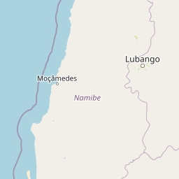
Map view of Namibe Partial Reserve

Use this park location map to pinpoint Namibe Partial Reserve in Angola, understand its exact geographic position, and read its mapped placement within the surrounding landscape more clearly.

Pigeon | © OpenStreetMap contributors
Park atlas

Compare adjacent arid reserves and regional conservation areas across southwestern Angola

Explore Parks Near Namibe Partial Reserve and Surrounding Protected Landscapes

Browse other parks near Namibe Partial Reserve to examine connected desert ecosystems and transfrontier conservation zones. Evaluating these adjacent protected landscapes provides a broader regional perspective on the arid terrain of southwestern Angola.
National parkNamibe Province
About 91 km away#1 closest

South

Iona National Park: Mapped Protected Landscape in Namibe Province, Angola

Explore the geographic extent and regional context of this national park.

Iona National Park stands as a protected natural area within the administrative region of Namibe Province, Angola. This atlas-focused entry provides detailed insights into the park's mapped boundaries, its regional geographic positioning, and its role as a conservation landscape. Users can engage with specific data to understand the terrain and protected land distribution within this significant Angolan national park.

Area
15,200 km²
Established
1964
IUCN
II
Relief
Mixed relief
National parkNamibia
About 158 km away#2 closest

South

Skeleton Coast National Park: Namibia's Remote Desert-Coast National Park Exploration

Mapped landscape, shipwrecks, and profound geographic isolation.

Delve into the Skeleton Coast National Park, a monumental protected area in Namibia defined by its stark desert and ocean interface. This page provides detailed geographic context for the park's vast expanse, highlighting its characteristic shipwrecks and the dramatic landscape where towering sand dunes confront the cold Atlantic. Understand the unique protected-area identity of this legendary coastal wilderness through its mapped features and remote setting.

Area
16,845 km²
Established
1971
IUCN
II
Relief
Lowland
National parkAngola
About 263 km away#3 closest

East

Bicuar National Park National Park: Explore Protected Landscape and Regional Geography in Angola

Mapped boundaries and geographic context for Bicuar National Park.

Bicuar National Park represents a distinct protected area within Angola, offering valuable insights into the nation's natural geography. As a designated national park, its mapped boundaries are crucial for understanding its spatial extent and ecological significance. This resource supports detailed atlas exploration, allowing for a deeper appreciation of the park's landscape and its role within the regional context of Southern Africa.

National parkAfrica
About 263 km away#4 closest

East

Bicuari National Park: An African National Park with Distinct Protected Landscape Identity

Explore its mapped geographic boundaries and regional terrain.

Bicuari National Park represents a vital component of Africa's protected lands network. This national park offers a specific focus on its unique geographic setting and the mapped extent of its protected boundaries. As an atlas entry, it provides critical context for understanding the park's landscape within the broader regional geography of the African continent, ideal for detailed geographic exploration.

National parkCunene Province
About 341 km away#5 closest

East

Mupa National Park National Park: Exploring Protected Landscapes and Geographic Context

Discover the mapped terrain and boundaries in Cunene Province.

Mupa National Park is a vital protected area within Cunene Province, Angola, serving as a key component of the region's conservation atlas. This national park represents a distinct geographic entity, offering detailed insights into its mapped landscape and protected boundaries. Users can explore Mupa National Park to understand its specific contribution to the protected lands of southern Angola and to appreciate its unique position within the broader regional geography and natural terrain.

Area
6,600 km²
Established
1964
Access
Access unknown
Scope
Terrestrial
National parkKunene Region
About 393 km away#6 closest

Southeast

Etosha National Park National Park: Mapped Protected Landscape and Regional Geography

Discover its protected boundaries and geographic context.

Gain a structured understanding of Etosha National Park, a prominent national park within Namibia's Kunene Region. This entry focuses on the park's protected landscape identity, detailing its mapped boundaries and geographic significance. Explore Etosha National Park through the lens of atlas-driven discovery, appreciating its role as a key protected area and its contribution to the regional geography of the surrounding landscape.

Area
22,270 km²
Established
1907
IUCN
II
Visitors
200K annual
Wildlife reserveOshana Region
About 434 km away#7 closest

Southeast

Oshana-System Wildlife Reserve: Mapping the Seasonal Wetlands of the Oshana Region

A complex network of drainage channels and savanna grasslands

The Oshana-System functions as an expansive inland wetland complex, defined by its flat, sandy terrain and cyclic flooding. This wildlife reserve spans significant portions of north-central Namibia, offering a distinct study in low-gradient hydrology and savanna-wetland transitions characterized by mopane woodland and makalani palms.

Area
30,000 km²
Relief
Lowland
Scope
Terrestrial
Water
Water-dominated
National parkNamibia
About 602 km away#8 closest

South

Dorob National Park: Namibia's Expansive Coastal Desert and Protected Bird Habitat

Explore mapped landscapes and regional geography.

Dorob National Park is a prime example of a protected coastal desert landscape, stretching along Namibia's Atlantic coast. This national park is renowned for its significant bird populations, making it an Important Bird Area with extensive mapped habitats supporting diverse species. Understand the park's geographic context, from its dramatic dunes to its ephemeral river systems, and its role as a key conservation area within the region.

Area
107,540 km²
Established
2010
IUCN
II
Relief
Lowland

Common questions about visiting, size, designation, and location context for Namibe Partial Reserve

Namibe Partial Reserve FAQs for park facts, access, geography, and protected area context

Find quick answers about Namibe Partial Reserve, including protected-area facts, park geography, trail and visitor context, and how the park fits into its surrounding country and regional landscape.
MoriAtlas Explorer

Continue Your Protected Areas Search Across the Global Atlas

Deepen your exploration by continuing the structured search for national parks and protected areas worldwide. Utilize the comprehensive filtering capabilities to compare different conservation landscapes and refine your understanding of global park geography. Discover more about the distribution and characteristics of protected natural areas.

Global natural geography