

Mori Atlas logo
Wildlife reserveNandur Madhameshwar Bird Sanctuary

Mapping the riparian ecosystems and avian habitats along the Godavari River basin

Nandur Madhameshwar Bird Sanctuary: A Protected Wetland Landscape in Maharashtra India

(Nandur Madhameshwar Wildlife Sanctuary)

Nandur Madhameshwar Bird Sanctuary represents a vital protected wetland complex located in the Nashik District of Maharashtra. This wildlife reserve features a unique mosaic of marshes, open waterbodies, and riparian woodland created by the confluence of the Godavari River and man-made weir structures. The sanctuary serves as a significant hub for both resident and migratory waterbirds within the regional landscape of western India.

wetlandbird sanctuaryramsar sitegodavari rivermaharashtramigratory birds

Nandur Madhameshwar Bird Sanctuary

Wildlife reserve

Park overview

Structured park overview, official facts, and landscape profile for Nandur Madhameshwar Bird Sanctuary

Nandur Madhameshwar Bird Sanctuary park facts, protected area profile, and essential visitor context

Review the core facts for Nandur Madhameshwar Bird Sanctuary, including designation, size, terrain, visitor scale, habitats, and operating context in one park-focused overview.

About Nandur Madhameshwar Bird Sanctuary

Nandur Madhameshwar Bird Sanctuary occupies a distinctive position among India's inland wetlands. Rather than being a natural lake or undisturbed floodplain, it is an engineered wetland, formed when a stone pick-up dam structure was built across the Godavari River at Nandur Madhameshwar. The resulting rise in local water levels and change in seasonal flooding patterns produced an extensive mosaic of marshes, ponds, channels and seasonally inundated grassland that quickly attracted waterbirds.

Quick facts and research context for Nandur Madhameshwar Bird Sanctuary

Nandur Madhameshwar Bird Sanctuary lies in Niphad Tehsil of Nashik District, Maharashtra, and is widely described as the state's Bharatpur because of its significance for birdwatching. The protected area covers roughly 100 square kilometers and is classified as IUCN Category IV, reflecting its role in managing habitat and species rather than as a strictly protected wilderness reserve.

Its ecological character was shaped by a stone pick-up weir constructed across the Godavari River at Nandur Madhameshwar, which raised local water levels and created the wetland mosaic that the sanctuary now protects. It was established in 1986 and was formally designated as a Ramsar Wetland in 2020, making it Maharashtra's first Ramsar site.

Protection and recognition

Documented terrestrial protection scope, designation year, and recognition records

Nandur Madhameshwar Bird Sanctuary Protection Status and Designation History

Nandur Madhameshwar Bird Sanctuary holds a documented terrestrial protection status established in 2020. Structured records provide baseline designation history and administrative context without external recognition sources.

Protection details

Protection scope
Terrestrial
Designated year
2020
Transboundary protection
No
Park context

Deeper park guide and search-rich context for Nandur Madhameshwar Bird Sanctuary

Nandur Madhameshwar Bird Sanctuary history, landscape, wildlife, and travel context

Explore Nandur Madhameshwar Bird Sanctuary through its history, landscape character, ecosystems, wildlife, conservation priorities, cultural context, and seasonal travel timing in a structured park guide built for atlas discovery and search intent.

Why Nandur Madhameshwar Bird Sanctuary stands out

Nandur Madhameshwar is best known for being a large, accessible birding wetland along the Godavari River in Maharashtra, supporting large flocks of migratory and resident waterbirds. The sanctuary's reputation as the Bharatpur of Maharashtra rests on its mix of open water, marshes and wooded islands, which together attract a wide variety of herons, ducks, raptors and waders. It is also recognized as Maharashtra's first Ramsar Wetland of International Importance, a designation that reflects the site's importance not only for birds but also for the broader riverine ecosystem developed around the dam-weir structure on the Godavari.
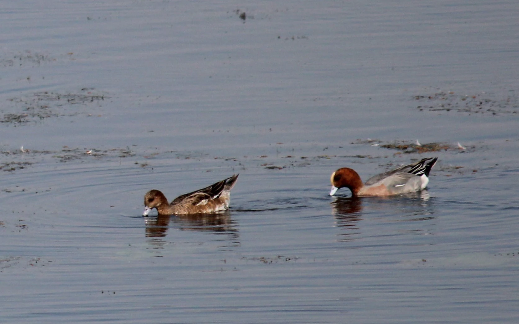
Two ducks swimming in calm, still water. One is a male Eurasian Wigeon with a distinctive chestnut-colored head and cream-colored crown, and the other is a female in mottled brown plumage.
A pair of Eurasian Wigeon ducks swimming in the wetlands of Nandur Madhameshwar Bird Sanctuary.

Nandur Madhameshwar Bird Sanctuary landscape and geographic character

The landscape of Nandur Madhameshwar is shaped by the interaction between the Godavari River and the weir structure near the sanctuary. Instead of a single large lake, the area consists of a network of shallow waterbodies, marshy edges, partially submerged fields and low islands of vegetation, all of which vary in size and depth with the seasonal flow of the river. The result is a patchwork wetland rather than a uniform reservoir.

Surrounding and interspersed among the waterbodies are stretches of scrub, grassland and planted woodland, with tree-lined banks and elevated patches providing drier habitat in contrast to the open water. This combination of open water, marshy margins, scrub and groves gives the landscape a layered character, with edges and transitions that are particularly important for wading birds, herons and species that prefer partially vegetated shallows.
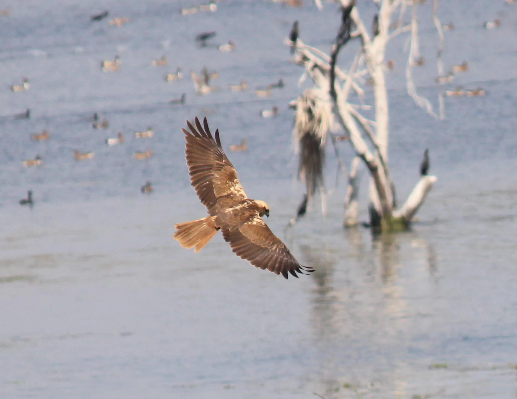
A brown female marsh harrier bird of prey flying over water with a dead white tree and other distant birds in the background.
A female marsh harrier in flight over the wetland at Nandur Madhameshwar Bird Sanctuary.

Nandur Madhameshwar Bird Sanctuary ecosystems, habitats, and plant life

The sanctuary's ecological identity centers on a freshwater wetland system created and sustained by the modified flow of the Godavari. Aquatic vegetation thrives in the shallow waters, while a variety of tree species grow along the banks, on islands and on slightly higher ground, producing a mixed habitat of aquatic, wetland and terrestrial vegetation.

Reported plant species include Babul, Tamarind, Neem, Jamun, Vilayati, Maharukh, Pangara, Mango and Eucalyptus, along with various aquatic plant species found in the waterbodies themselves. This blend of native and planted species contributes to a heterogeneous habitat structure, where clumps of trees interrupt open water patches and damp margins are interspersed with grassy areas. Such variety in habitat types is central to the sanctuary's ability to support a wide range of bird species across seasons.
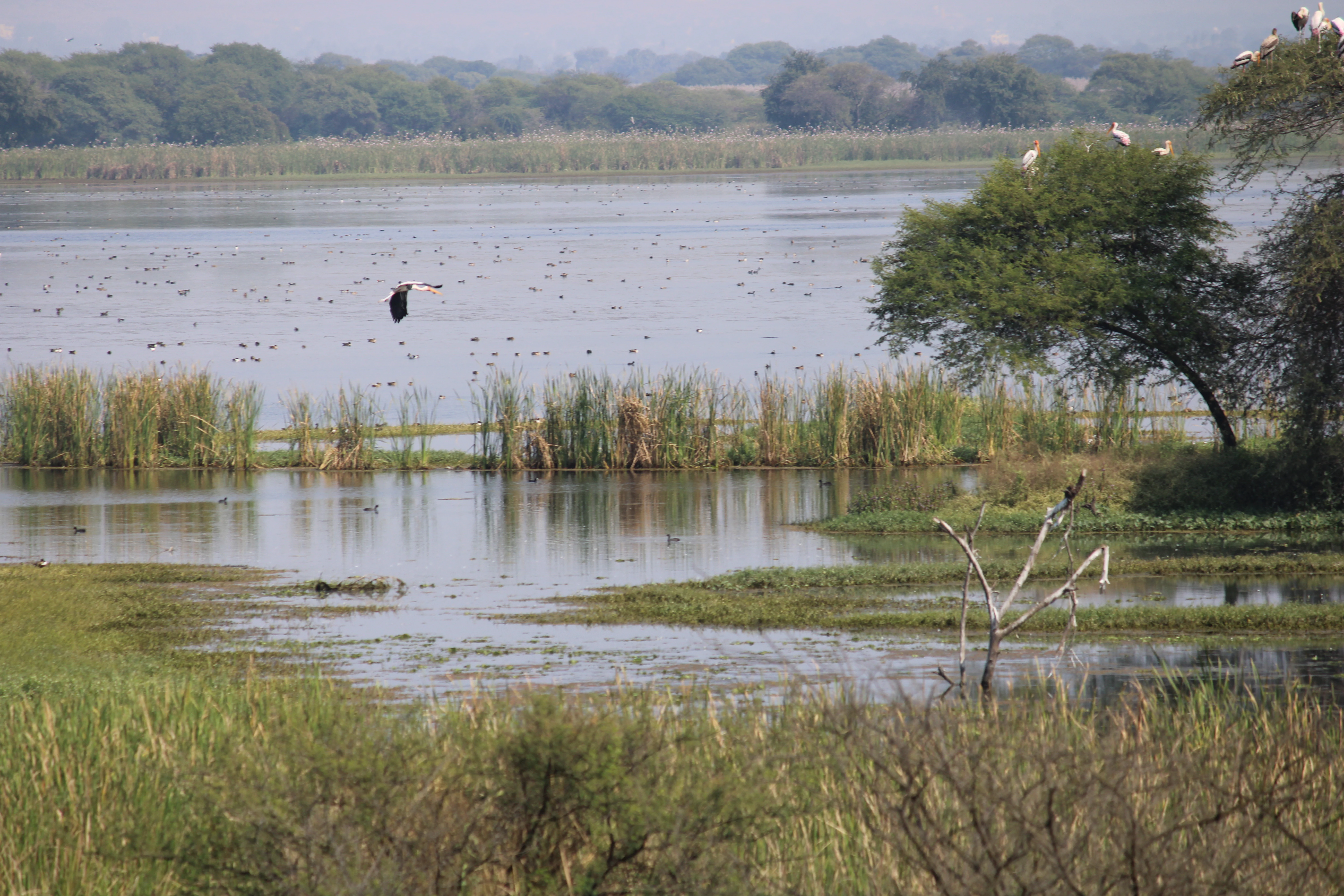
A wide shot of a wetland landscape with tall grasses, calm water, and trees where birds are resting and flying.
A tranquil view of the wetland ecosystem at Nandur Madhameshwar Bird Sanctuary, home to various bird species.

Nandur Madhameshwar Bird Sanctuary wildlife and species highlights

Nandur Madhameshwar is fundamentally a bird sanctuary, and its wildlife profile is dominated by waterbirds and associated species. The combination of open water, marshy shallows and tree cover supports a mix of waders, swimmers and raptors, with marsh harriers and Eurasian wigeons among the species visually associated with the site.

The sanctuary functions as a refuge for resident species as well as a seasonal destination for migratory birds, which arrive in large numbers during the winter months when the wetlands hold more water and food resources. Beyond birds, the mosaic of aquatic and terrestrial habitats also supports a broader community of wetland-dependent fauna typical of Indian riverine environments, although the sanctuary's identity and visitor emphasis are strongly oriented toward birdlife.

Nandur Madhameshwar Bird Sanctuary conservation status and protection priorities

Nandur Madhameshwar has formal recognition as a protected area at both national and international levels. It was established as a sanctuary in 1986 and is classified under IUCN Category IV, indicating a focus on managing habitat and specific species rather than on strict wilderness protection.

In 2020, the site was designated as the Nandur Madhameshwar Ramsar Wetland, becoming Maharashtra's first Ramsar site. This Ramsar designation marks the sanctuary as a Wetland of International Importance under the Ramsar Convention, placing it within a global framework for wetland conservation. The sanctuary's conservation value lies in its role as a modified but functioning riverine wetland that sustains significant bird populations and exemplifies how engineered river structures can, with adequate management, generate ecologically valuable habitat.

Top sights and standout views in Nandur Madhameshwar Bird Sanctuary

The sanctuary's main highlights revolve around its identity as a flagship birding destination in Maharashtra and the state's entry point into the international Ramsar network of important wetlands. Its bird-rich waterbodies, set within a working rural landscape, give it a distinctive feel that sets it apart from either remote forested reserves or purely natural lakes.

The combination of accessible location, large size for an inland wetland sanctuary, and formal Ramsar recognition makes Nandur Madhameshwar a key reference point in discussions about wetland conservation in the Godavari basin and in Maharashtra more broadly.

Best time to visit Nandur Madhameshwar Bird Sanctuary

As a wetland-dependent bird sanctuary, Nandur Madhameshwar is typically at its most rewarding when water levels are favorable for waterbirds and migratory species, generally during the cooler months in Maharashtra when many northern migrants are present. Outside this peak season, the area still functions as a productive wetland but may offer different bird activity patterns.

Seasonal visit timing is closely tied to both rainfall and bird migration cycles on the Deccan plateau. Wetland condition and bird activity can fluctuate with the monsoon's influence on the Godavari's flow and the sanctuary's water levels.
Monthly climate preview

Long-term temperature ranges and monthly precipitation metrics for protected terrain

Nandur Madhameshwar Bird Sanctuary Climate Normals and Annual Weather Patterns

Representative coordinates record distinct shifts in annual temperature and precipitation across twelve recorded periods. Reviewing the complete monthly data provides deeper context for the measured environmental rhythm at this location.
Annual mean24 °C
21 °C29 °C
Jan21°
Feb23°
Mar27°
Apr29°
May29°
Jun27°
Jul24°
Aug24°
Sep24°
Oct23°
Nov22°
Dec21°
Warmest month
May

29.4 °C

Coolest month
December

20.7 °C

Wettest month
July

15.7 mm/day

Driest month
January

0.1 mm/day

Park location guide

Geography guide, regional context, and park location map for Nandur Madhameshwar Bird Sanctuary

Nandur Madhameshwar Bird Sanctuary park geography, regions, and map view in India

Understand where Nandur Madhameshwar Bird Sanctuary sits in India through a broader geographic reading of the surrounding landscape, nearby location context, and its mapped position within the national park landscape.

How Nandur Madhameshwar Bird Sanctuary fits into India

India is a South Asian country bordered by the Indian Ocean, Arabian Sea, and Bay of Bengal. It shares land borders with Pakistan, China, Nepal, Bhutan, Bangladesh, and Myanmar. The country has a population of over 1.4 billion people and operates as a federal parliamentary republic with its capital in New Delhi.

Wider geography shaping Nandur Madhameshwar Bird Sanctuary in India

India occupies the Indian subcontinent in South Asia, bordered by the Arabian Sea to the southwest, the Bay of Bengal to the southeast, and the Indian Ocean to the south. It shares land borders with Pakistan to the west, China, Nepal, and Bhutan to the north, and Bangladesh and Myanmar to the east. The territory also includes the Andaman and Nicobar Islands in the Indian Ocean.

Map view of Nandur Madhameshwar Bird Sanctuary

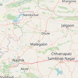
Use this park location map to pinpoint Nandur Madhameshwar Bird Sanctuary in India, understand its exact geographic position, and read its mapped placement within the surrounding landscape more clearly.

Pigeon | © OpenStreetMap contributors

Location context for Nandur Madhameshwar Bird Sanctuary

Maharashtra

Visualizing the marshes, open water, and riparian habitats of the Godavari floodplain

Nandur Madhameshwar Bird Sanctuary Photos and Wetland Landscape Scenery

Explore curated photography documenting the diverse wetland ecosystems, shallow marshes, and wooded islands of Nandur Madhameshwar Bird Sanctuary. Detailed visual records reveal the terrain, seasonal flooding patterns, and protected habitats that define this important conservation landscape.

Two ducks swimming in calm, still water. One is a male Eurasian Wigeon with a distinctive chestnut-colored head and cream-colored crown, and the other is a female in mottled brown plumage.

A brown female marsh harrier bird of prey flying over water with a dead white tree and other distant birds in the background.

A wide shot of a wetland landscape with tall grasses, calm water, and trees where birds are resting and flying.

Park atlas

Compare regional wetlands, river basins, and surrounding conservation landscapes.

Explore Protected Areas and Parks Near Nandur Madhameshwar Bird Sanctuary

Browse nearby national parks and protected areas sharing similar wetland and riverine geography. Comparing adjacent sanctuaries offers deeper insight into regional conservation networks across the surrounding landscape.
National parkNavsari District
About 98 km away#1 closest

Northwest

Vansda National Park: Protected Deciduous Forest Landscape within the Western Ghats

Explore the mapped geography and biodiversity of this Navsari District national park.

Vansda National Park stands as a crucial protected area in Navsari District, Gujarat, preserving the characteristic dense deciduous forests and extensive bamboo groves of the Western Ghats. The park's geography is shaped by its location along the Ambika River, presenting a landscape of rolling hills and forested valleys within this significant biodiversity hotspot. Users can delve into its protected land status, mapped terrain, and the unique ecological attributes that make it a noteworthy national park for geographic and conservation exploration.

Area
23.99 km²
Established
1979
IUCN
II
Relief
Highland
National parkMaharashtra
About 135 km away#2 closest

Southwest

Sanjay Gandhi National Park: Protected Forest Landscape and Ancient Buddhist Archaeology

Explore the mapped terrain and natural geography within Maharashtra.

Sanjay Gandhi National Park offers a unique blend of natural and historical discovery. This national park preserves vital tropical forest ecosystems characteristic of the Western Ghats region, providing a crucial urban wilderness habitat. Its most prominent feature is the Kanheri Caves, an extensive network of ancient rock-cut Buddhist structures showcasing over 2,400 years of continuous religious and cultural history. The park's protected boundaries encompass diverse terrain, supporting leopard populations and a rich variety of bird and insect life, all within the metropolitan limits of Mumbai, making it a significant site for geographic and conservation exploration.

Area
87 km²
Established
1996
IUCN
II
Visitors
2M annual
A soft watercolor illustration of a circular lake within a shallow impact crater, characterized by pale green and earthy tones against a white background.
Natural monumentMaharashtra
About 260 km away#3 closest

East

Lonar Lake Natural Monument: Geological Impact Crater and Protected Landscape in Maharashtra

Mapping the unique saline basin of an Indian impact site

Lonar Lake stands as an exceptional geological feature on the Deccan Plateau, formed by a massive meteorite impact that created a symmetric crater basin. This protected site features saline soda waters and distinct microbial ecosystems nestled within steep, forested slopes. The area encompasses both a rare natural landmark and a significant cultural heritage zone, providing a unique focus for geographic and scientific exploration in western India.

Area
1.13 km²
Established
2000
Relief
Upland
Climate
Tropical
National parkMadhya Pradesh
About 270 km away#4 closest

North

Dinosaur Fossils National Park: Protected Area and National Park in Madhya Pradesh

Explore mapped boundaries and regional geography.

Dinosaur Fossils National Park stands as a distinct national park within Madhya Pradesh, offering a unique focus for geographic exploration. This entry provides essential details about its protected status, mapped landscape features, and its place within India's network of conservation areas. Engage with structured data that details the park's regional context and natural terrain for comprehensive atlas-based understanding.

Area
0.894 km²
Established
2011
IUCN
II
Relief
Lowland
National parkBhavnagar District
About 303 km away#5 closest

Northwest

Blackbuck National Park: Gujarat's Grassland Protected Landscape and Wildlife Atlas

Mapped semi-arid terrain and endangered species habitat.

Blackbuck National Park in Bhavnagar District, India, presents a unique focus on semi-arid grassland ecosystems and their protection. This national park showcases a flat, expansive landscape that borders coastal tidal zones, offering a distinct geographic context for its rich biodiversity. As a critical habitat for the blackbuck antelope and the endangered lesser florican, its protected area status is paramount. Exploring this park through its mapped boundaries and regional geography reveals its importance within India's network of conservation landscapes.

Area
34.08 km²
Established
1976
IUCN
II
Relief
Lowland
National parkIndia
About 313 km away#6 closest

South

Chandoli National Park: A National Park within India's Protected Lands Atlas

Mapped boundaries and regional landscape context for this protected area.

Chandoli National Park represents a distinct protected area within India, offering specific insights into national park landscapes and their geographic distribution. This entry focuses on its identity as a national park, detailing its mapped boundaries and regional context. It serves as a critical point for understanding the park's landscape within the atlas, providing factual geographic information for exploration and comparative study.

Area
317.67 km²
Established
2004
IUCN
II
Relief
Mountain
National parkGujarat
About 358 km away#7 closest

West

Gir National Park: Gujarat's Key National Park with Protected Landscape Identity

Understanding the geography and mapped boundaries of this Indian protected area

Gir National Park represents a crucial protected landscape within the Gujarat region of western India. This MoriAtlas entry focuses on its role as a national park, detailing its geographic setting and the mapped extent of its protected area. Users can delve into the specific landscape character and regional context that defines Gir National Park, making it a vital point for structured exploration of India's protected lands and natural geography.

Area
1,410.3 km²
Established
1965
IUCN
IV
Visitors
60.1K annual
National parkMaharashtra
About 362 km away#8 closest

Northeast

Gugamal National Park: A National Park Within Maharashtra's Geographic Atlas

Explore its mapped boundaries and regional landscape context.

Gugamal National Park represents a critical protected natural landscape within the state of Maharashtra, India. As a designated national park, it provides essential context for understanding the region's geography and the spread of conservation efforts. Users can explore the park's mapped boundaries and its role within the broader atlas of protected areas, contributing to a detailed geographic understanding.

Area
361.28 km²
Established
1974
IUCN
II
Relief
Upland

Common questions about visiting, size, designation, and location context for Nandur Madhameshwar Bird Sanctuary

Nandur Madhameshwar Bird Sanctuary FAQs for park facts, access, geography, and protected area context

Find quick answers about Nandur Madhameshwar Bird Sanctuary, including protected-area facts, park geography, trail and visitor context, and how the park fits into its surrounding country and regional landscape.
MoriAtlas Explorer

Continue Your Protected Areas Search Across the Global Atlas

Deepen your exploration by continuing the structured search for national parks and protected areas worldwide. Utilize the comprehensive filtering capabilities to compare different conservation landscapes and refine your understanding of global park geography. Discover more about the distribution and characteristics of protected natural areas.

Global natural geography