Mori Atlas logo
Regional parkNaturpark Beverin

Mapping the dramatic river gorges, high-altitude ridges, and cultural settlement traditions.

Naturpark Beverin: Regional Nature Park and Alpine Geography in Graubünden, Switzerland

Naturpark Beverin spans 515 square kilometers across the Graubünden region, representing a vertical landscape that shifts from deep river gorges like the Viamala to the high alpine ridges of the Piz Beverin massif. This protected area connects diverse natural terrain including mountain lakes, peatlands, and stone pine forests with historic alpine transit corridors. It serves as a vital habitat for the Alpine ibex, while preserving the contrasting cultural traditions of Romanesque and Walser settlements in the eastern Central Alps.

regional nature parkalpine sceneryriver gorgesIberian ibexRomanesque heritageWalser settlements

Naturpark Beverin

Regional park

Park overview

Structured park overview, official facts, and landscape profile for Naturpark Beverin

Naturpark Beverin park facts, protected area profile, and essential visitor context

Review the core facts for Naturpark Beverin, including designation, size, terrain, visitor scale, habitats, and operating context in one park-focused overview.

About Naturpark Beverin

Naturpark Beverin is a regionally anchored nature park in the eastern Swiss Alps, designed to link ecological protection with sustainable regional development. Created in 2013 under the Swiss federal park label and coordinated through the Beverin Park Association, it spans nine municipalities: Andeer, Ferrera, Muntogna da Schons, Rheinwald, Rongellen, Safiental, Sufers, Tschappina, and Zillis-Reischen.

Geographically, the park covers a vertical band of the Alps from about 600 to 3200 meters, descending from glaciated high country through subalpine pastures and forests to deeply incised river valleys. The Hinterrhein and Vorderrhein have cut three signature gorges through the park: Viamala, the Roflaschlucht, and the Ruinaulta Rheinschlucht. Two historic north-south alpine crossings, the Splügen and San Bernardino passes, also run through the territory, with the Bernardino route having been the first paved alpine pass road when it opened in 1823.

What distinguishes Naturpark Beverin is the combination of a strong ecological mandate with a deeply rooted cultural landscape. The park's nine municipalities preserve centuries-old pastoral land use, including species-rich dry meadows and pastures, forest grazing areas, and traditional settlement patterns. The Beverin hunting reserve at the core of the park is one of the oldest protected areas in Graubünden, today home to a thriving ibex colony that has become the park's most recognizable symbol.

Quick facts and research context for Naturpark Beverin

Naturpark Beverin lies in the eastern Central Alps of the Swiss canton of Graubünden and covers an area of approximately 515 square kilometers across nine municipalities. It was officially recognized as a regional nature park of national importance in 2013, following years of planning that began with the 2001 idea for a regional park on the Schamserberg.

The park encompasses elevations from roughly 600 to 3200 meters, producing a vertical sequence of alpine, subalpine and valley habitats crossed by three major river gorges: the Viamala, the Rofla, and the Ruinaulta (Rheinschlucht). It is a member of the Swiss Parks Network and works closely with the ZHAW Institute for Environment and Natural Resources on research and sustainable development. At its core is the Beverin hunting reserve, established in 1886, where the now-iconic ibex population was reintroduced in 1954.

Protection and recognition

Terrestrial conservation framework and designation history for Naturpark Beverin

Naturpark Beverin Protection Status and International Recognition Facts

Naturpark Beverin holds documented terrestrial protection status established in the year 2013. Review the official designation history and management scope details associated with this protected landscape.

Protection details

Protection scope
Terrestrial
Designated year
2013
Transboundary protection
No
Park context

Deeper park guide and search-rich context for Naturpark Beverin

Naturpark Beverin history, landscape, wildlife, and travel context

Explore Naturpark Beverin through its history, landscape character, ecosystems, wildlife, conservation priorities, cultural context, and seasonal travel timing in a structured park guide built for atlas discovery and search intent.

Why Naturpark Beverin stands out

Naturpark Beverin is best known for the dramatic alpine scenery of the Piz Beverin massif and the deep river gorges that cut through the park, especially the Viamala. The park combines high-mountain terrain, classic alpine cultural landscapes, and two contrasting settlement cultures: compact Romanesque villages and dispersed Walser hamlets. It is also recognized for one of Switzerland's most important ibex populations. The 31.52 square kilometer Beverin hunting reserve, established in 1886, was the site of the 1954 ibex reintroduction that gave the park its emblem and the name of its research and visitor centers, including the Center da Capricorns in Wergenstein and the Steinbock exhibition.
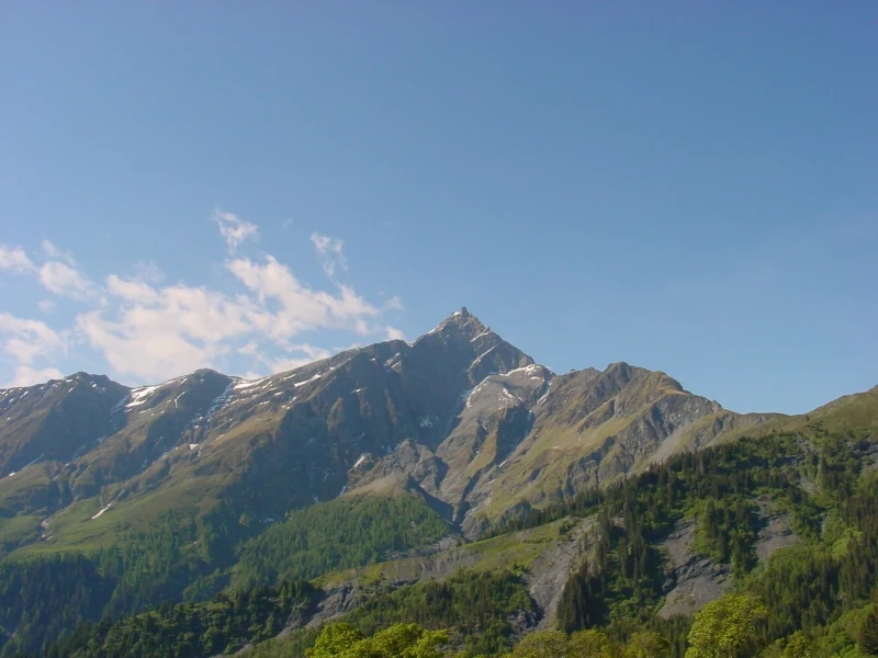
A wide, clear-day view of the sharp, rocky peak of Piz Beverin rising above a forested alpine slope.
The north face of Piz Beverin, a prominent summit within Naturpark Beverin.

Naturpark Beverin history and protected-area timeline

Planning for what would become Naturpark Beverin began in 2001, when the idea of a regional nature park on the Schamserberg was first proposed. Early efforts quickly revealed that the proposed perimeter was too small and that financing was not yet secure, prompting a shift toward a broader regional development approach. In 2003, the Center da Capricorns project for sustainable regional development was launched on the Schamserberg.

In 2005, the Fundaziùn Capricorn was founded to drive the regional nature park project forward. A core park working group was established in 2006, and the 2007 revision of the Swiss Nature and Heritage Protection Act opened the legal pathway for new parks. An external office of the ZHAW Institute for Environment and Natural Resources was opened at the Center da Capricorns in Wergenstein to guide sustainable tourism and development planning.

By 2009, the park's management plan had been submitted to the Swiss Federal Office for the Environment (BAFU) and the project received candidacy status. The Naturpark Beverin association was founded the same year to coordinate further development. In 2011, assembly votes across all the involved communities showed broad support for the park, and the Beverin Charter was submitted to BAFU in 2012. The park received its national label in 2013, marking the start of its first operating phase.

Further development came through the 2015 founding of the Association of Graubünden Parks, which strengthened joint work among the canton's parks. The park boundary was extended in 2016 with the merger creating the municipality of Safiental, reaching into the Rheinschlucht, and again in 2020 when Rheinwald joined after the dissolution of the Parc Adula national park project. A vote on the second operating phase was held in 2021, and the second phase officially began in 2023, running through 2032.

Naturpark Beverin landscape and geographic character

Naturpark Beverin occupies a striking vertical slice of the eastern Central Alps. Elevations from roughly 600 meters in the river valleys up to about 3200 meters on the alpine ridges create layered landscapes that range from deeply carved river gorges to high pastures, rock faces, mountain lakes, and peatlands.

Three gorges define the character of the park's river systems. The Viamala and the Roflaschlucht both cut through the Hinterrhein valley, while the Ruinaulta, often called the Rheinschlucht or Swiss Grand Canyon, lies along the Vorderrhein. These gorges contrast sharply with the more open alpine plateaus, broad side valleys, and the high-elevation Massif of Piz Beverin that gives the park its name.

Human-shaped landscape features are equally prominent. Centuries of grazing and hay-making have produced a mosaic of meadows, dry pastures and forest pastures, while the two major passes of Splügen and San Bernardino have shaped transit corridors through the mountains since Roman times. The old Bernardino pass road, first paved in 1823 and now the A13 motorway, runs through the park as a north-south alpine artery.

Naturpark Beverin ecosystems, habitats, and plant life

The park supports a wide spectrum of habitats because of its strong altitudinal gradient and its mix of wet and dry environments. Alpine limestone landscapes with mountain lakes and peatlands sit alongside drier valley slopes and lush river and floodplain systems along the Hinterrhein and Vorderrhein. Cultivated landscapes of long standing, including species-rich dry meadows and pastures as well as forest grazing, contribute significantly to biodiversity.

Dry meadows and pastures of national importance, hay meadows, and uncut border strips form an important habitat mosaic, particularly on the high plateau above Muntogna da Schons, where populations of the otherwise declining Eurasian skylark remain unusually dense. Wetland habitats along the rivers and in the Rheinschlucht provide key conditions for specialized species, including the river lapwing and the common sandpiper, as well as rare plants such as swollen scorpion moss and chestnut-brown rush.

Forest zones, subalpine shrublands, and high alpine pastures make up the vertical sequence of habitats. Mountain forests, open rock and scree slopes, and alpine grasslands combine to support a broad range of plants, fungi, insects such as grasshoppers and butterflies, and the many larger mammals and birds for which the park is known.

Naturpark Beverin wildlife and species highlights

Naturpark Beverin hosts a notably rich alpine fauna, anchored by the Beverin hunting reserve, established in 1886 at the park's core. The area became internationally recognized when ibex, extinct in the region in the nineteenth century, were reintroduced in 1954. The current Safien-Rheinwald colony numbers around 400 ibex, and the ibex, known as Capricorn in the local Sutsilvan idiom, has become the park's emblem.

Beyond ibex, the park's ungulate communities include red deer, chamois, and roe deer. Predators and scavengers are also present, with wolves and lynx occurring in the area, alongside golden eagles and, more rarely, bearded vultures and seasonal griffon vultures. Marmots, mountain hares and European hares inhabit the open slopes, while reptiles such as the asp viper and grass snake occupy lower, warmer terrain.

Birdlife is particularly varied. Alongside the dense skylark populations noted above, grouse species including ptarmigan, capercaillie and black grouse breed in the park, together with whinchats, wrynecks, red-backed shrikes, and the corncrake. Insect diversity is also a focus of conservation work, with targeted efforts to maintain habitats for grasshoppers and butterflies across dry meadows and pastures.

Naturpark Beverin conservation status and protection priorities

Naturpark Beverin plays a significant role in protecting a vertically layered, ecologically diverse section of the eastern Swiss Alps. Its conservation framework rests on three pillars: long-standing habitat protection, targeted species conservation, and the maintenance of traditional cultural landscapes that support biodiversity.

At the heart of the system is the 31.52 square kilometer Beverin hunting reserve, the second-oldest protected area in the canton of Graubünden and home to one of Switzerland's most important ibex populations. The park actively supports threatened species such as the Eurasian skylark, rare bat species including the alpine long-eared bat, and specialized river-gorge birds and plants in the Ruinaulta. Measures include keeping dry meadows and pastures open, preserving uncut border strips for ground-nesting birds, and managing habitats for grasshoppers and butterflies.

Beyond species-level work, the park links conservation to regional development, sustainable energy, and education. Its programs promote local renewable resources, including hydropower and the world's first solar-powered ski lift at Tenna, while education for sustainable development initiatives engage residents and visitors in habitat stewardship and volunteer work parties.

Naturpark Beverin cultural meaning and human context

The cultural fabric of Naturpark Beverin is defined by two distinct alpine settlement traditions. In the Val Schons, the local population speaks the Sutsilvan idiom, the smallest of the five Romansh varieties, and lives in compact Romanesque villages. The parish church of St. Martin in Zillis, famous for its painted Romanesque ceiling from the early twelfth century, stands as one of the canton's most important medieval art treasures.

In the Rheinwald, Tschappina and Safiental valleys, the cultural identity is Walser, the descendants of medieval settlers from Valais. Walser villages are characterized by dispersed hamlets and traditional shingle-roofed buildings, and organizations such as the Safier Ställe association maintain these structures by fitting new shingle roofs on historic stables. The Reformed Church of Tenna, with nationally significant wall paintings, is another highlight of Walser heritage within the park.

Mining has shaped parts of the territory for centuries. The Val Schons and Val Ferrera hosted ore mining at twenty-four historical sites and were once among the canton's most important mining districts. Today, quarrying of Andeer granite remains part of the regional economy, while exhibitions in Innerferrera and Wergenstein link visitors to this layered industrial and cultural past.

Top sights and standout views in Naturpark Beverin

Naturpark Beverin's highlights lie in the contrast between high-alpine massifs, deeply carved gorges, and a strongly rooted alpine cultural landscape. The towering Piz Beverin massif and the dramatic Hinterrhein and Vorderrhein gorges of Viamala, Roflaschlucht, and Ruinaulta anchor the park's visual identity. Hiking routes such as the Via Spluga, Via Capricorn, and the Walserweg Safiental traversing the park link these natural landmarks with its two distinct cultural regions. The Beverin hunting reserve, with one of Switzerland's largest ibex populations, gives the park a powerful ecological symbol, while the Center da Capricorns in Wergenstein ties research, education and visitor experiences around this flagship species. Notable cultural stops include the Romanesque painted ceiling at St. Martin in Zillis, the Walser settlement heritage of the Safiental, and the historic mining landscape of Val Schons and Val Ferrera.

Best time to visit Naturpark Beverin

Naturpark Beverin offers clearly different seasonal experiences shaped by its alpine elevation range. Summer and early autumn are the most rewarding periods for hiking, with extensive trail networks across the long-distance Via Spluga, Via Capricorn, and Walserweg, dry meadow blooms, and warm conditions in the lower valleys and gorges. Winter transforms the park into a quieter landscape of ski tours, winter hiking, snowshoe routes, cross-country skiing, sledding, and small ski areas at Splügen-Tambo, Tschappina and the solar-powered lift in Tenna. Spring is a season of strong contrasts, with snow lingering at higher elevations while valley meadows and the Ruinaulta gorge begin to fill with early-season visitors and breeding bird activity.

Monthly climate preview

Long-term representative point measurements tracking monthly temperature and precipitation rhythm

Naturpark Beverin Climate Normals and Annual Weather by Month

Representative point records for Naturpark Beverin document a multi-year thermal range spanning sub-zero winter minimums to moderate summer maximums alongside varying monthly precipitation rates. Detailed long-term climate normals provide comprehensive monthly meteorological data for deeper analytical study.
Annual mean1 °C
-10 °C11 °C
Jan-10°
Feb-9°
Mar-6°
Apr-1°
May
Jun
Jul11°
Aug11°
Sep
Oct
Nov-4°
Dec-8°
Warmest month
July

11 °C

Coolest month
January

-9.5 °C

Wettest month
June

5 mm/day

Driest month
February

1.8 mm/day

Park location guide

Geography guide, regional context, and park location map for Naturpark Beverin

Naturpark Beverin park geography, regions, and map view in Switzerland

Understand where Naturpark Beverin sits in Switzerland through a broader geographic reading of the surrounding landscape, nearby location context, and its mapped position within the national park landscape.

How Naturpark Beverin fits into Switzerland

Switzerland is a landlocked federal republic in Central Europe comprising 26 cantons, with Bern as the federal city and Zurich as the largest city. The country features the Swiss Alps, Swiss Plateau, and Jura Mountains, with German, French, Italian, and Romansh as official languages. It is noted for its political neutrality, direct democracy traditions, and strong economy.

Wider geography shaping Naturpark Beverin in Switzerland

Switzerland is located in Central Europe at the intersection of Western and Southern Europe. It is bordered by Germany to the north, France to the west, Austria and Liechtenstein to the east, and Italy to the south. The country is geographically divided among the Swiss Alps (covering most of the territory), the Swiss Plateau (where most of the population resides), and the Jura Mountains. Switzerland is landlocked.

Map view of Naturpark Beverin

Use this park location map to pinpoint Naturpark Beverin in Switzerland, understand its exact geographic position, and read its mapped placement within the surrounding landscape more clearly.

Pigeon | © OpenStreetMap contributors

Location context for Naturpark Beverin

Graubünden
Natural feature types

Explore the Natural Features and Alpine Landscapes of Naturpark Beverin

Continue geographic discovery through the diverse landforms associated with Naturpark Beverin. MoriAtlas offers structured access to the documented river gorges, peaks, and mountain pastures that constitute this significant alpine region in the Swiss canton of Graubünden.
Recorded earthquake history

Explore the Historical Earthquake Catalogue for Naturpark Beverin

Access a detailed archive of recorded seismic activity associated with the geography of Naturpark Beverin. Use this collection to review past earthquake data, including magnitudes and epicentre distances, compiled for clear geographical and regional research within the Swiss Alps.

Naturpark Beverin Earthquake History

Catalogued events

81 events

Strongest magnitude

Magnitude 4.8

Most recent event

Apr 26, 2026

This history includes earthquakes recorded inside the park or within 50 km of its borders

Explore protected area views, river gorges, and mountain habitats across the Swiss Alps

Naturpark Beverin Photos and Landscape Scenery: Visualizing Alpine Terrain

Visual documentation captures the dramatic vertical relief, deep river gorges, and high-alpine massifs that define the protected landscape. Examining actual park photography helps researchers and visitors understand the varied terrain, habitats, and cultural valleys more clearly.

A wide, clear-day view of the sharp, rocky peak of Piz Beverin rising above a forested alpine slope.

Park atlas

Compare regional protected areas and connected mountain terrain across the Swiss Alps

Explore Other Parks Near Naturpark Beverin And Surrounding Alpine Landscapes

Browse nearby protected landscapes and related alpine reserves sharing geographic traits with Naturpark Beverin. Expanding the search reveals regional park connections and comparative mountain terrain across the eastern Central Alps.
A soft watercolor painting depicting a wide river flowing through a green floodplain with distant mountains in the background.
Nature reserveGraubünden
About 3 km away#1 closest

North

Naturschutzgebiet Rhäzünser Rheinauen: Protected River Landscape and Floodplain Geography

Graubünden Alpine floodplain and alluvial river system

Located in the Swiss canton of Graubünden, Naturschutzgebiet Rhäzünser Rheinauen encompasses 157 hectares of rare, free-flowing river landscape. This protected area supports a diverse succession of plant communities, ranging from pioneer species on shifting gravel bars to mature softwood and hardwood floodplain forests, framed by the dramatic mountain terrain of the Hinterrhein valley.

Area
1.569 km²
Established
1992
IUCN
IV
Relief
Mountain
A soft watercolor illustration of a green alpine valley with distant mountains in light yellow and purple tones.
Regional parkCanton of Graubünden
5.4 km away#2 closest

Naturpark Calancatal: Protected Alpine Valleys and Mountain Geography in Graubünden

Mapping regional landscapes and mountain terrain in Southern Switzerland

Spanning 13,900 hectares, Naturpark Calancatal protects a near-entire alpine side valley defined by the Calancasca stream. From high glacier-fed headwaters to Mediterranean-influenced gorges, the park offers a unique look at the diverse mountain terrain, alpine pastures, and protected forests within the Canton of Graubünden.

Area
139.21 km²
Established
2024
Relief
Mountain
Climate
Alpine
Watercolor illustration of a panoramic mountain landscape with soft green hills, rolling ridgelines in shades of pink and purple, and small patches of blue water in the foreground.
Regional parkCanton of Graubünden
About 15 km away#3 closest

East

Parc Ela: Regional Nature Park and Alpine Geography in the Canton of Graubünden

A vertical protected landscape in the Swiss Alpine arc.

Parc Ela encompasses a remarkable span of Swiss Alpine geography, protecting everything from low-lying forested gorges at seven hundred meters to high-altitude peaks over three thousand meters. The park serves as a vital refuge for threatened insect species and large alpine mammals, while preserving the linguistic and architectural heritage of the Albula and Oberhalbstein valleys. Explore the mapped terrain where paleontological treasures meet historic trade routes.

Area
659 km²
Established
2012
Relief
Mountain
Climate
Alpine
A minimalist watercolor painting depicting a winding river through a flat alpine valley surrounded by gentle mountain ridges.
Nature reserveGraubünden
About 15 km away#4 closest

West

Aue Plaun la Greina Nature Reserve: Geography and Mapped Landscape Context

A protected high-alpine floodplain in the Swiss canton of Graubünden.

Aue Plaun la Greina sits within a high plateau between three major Adula mountain massifs, defined by its braided river channels, glacial moraines, and sensitive alpine mire habitats. The reserve protects a unique ecosystem that survives in a harsh, tundra-like climate at the heart of the European watershed, representing a major achievement in regional landscape preservation and geological study.

Area
0.39 km²
Established
1992
IUCN
IV
Relief
Mountain
A horizontal watercolor painting depicting a soft-focus mountain landscape with green rolling hills in the foreground and pale yellow mountain silhouettes in the distance.
Protected landscapeGraubünden
About 21 km away#5 closest

West

Greina, Piz Medel: Exploring the Geography of a Swiss Protected Landscape

High-alpine plateau, glacier forelands, and mountain peaks.

The Greina, Piz Medel protected area is defined by the contrast between its broad, level plateau and the surrounding ring of summits in the Adula Alps. This high-altitude region holds nationally important floodplains, diverse dry meadows, and active glacial basins that cross the European watershed, providing a profound study in alpine terrain and environmental conservation.

Area
150 km²
Established
1996
Relief
Mountain
Climate
Alpine
A horizontal watercolor illustration showing stylized, overlapping mountain ridges in shades of soft green, pink, and yellow against a white background.
Natural monumentGraubünden
About 27 km away#6 closest

Southeast

Roseggletscher Natural Monument: Alpine Glacier Geography and Proglacial Lake Mapping

Protected landscape data for the Bernina range in Graubünden.

Examine the geographic boundaries and terrain of the Roseggletscher, a protected natural monument situated in the upper Val Roseg. This record captures its glacial extent, the emergence of the Lej da Vadret proglacial lake, and its role within the wider Bernina glacier ensemble of southeastern Switzerland.

Area
6.38 km²
Relief
Mountain
Climate
Alpine
Access
Moderate access
Nature reserveLombardia
About 28 km away#7 closest

Southeast

Val di Mello Nature Reserve: Mapping the Granitic Geography of the Italian Alps in Lombardia

A study of protected vertical relief, glacial cirques, and Alpine terrain.

Val di Mello offers a profound look at high-altitude Alpine geography, characterized by its immense, light-colored granitic walls and deeply carved tributary valleys. This protected nature reserve acts as a gateway to the broader mountainous terrain of the Lombardia region, showcasing the geological evolution of the Italian Alps through its steep gullies, high summits, and expansive valley floor.

Established
2009
Relief
Mountain
Access
Moderate access
Scope
Terrestrial
A soft watercolor painting of a river winding through a valley with green trees, grassy plains, and distant purple hills against a white background.
Nature reserveGraubünden
About 29 km away#8 closest

East

Naturschutzgebiet Isla Glischa-Arvins-Seglias Nature Reserve in Graubünden

Mapped alluvial terrain and alpine river geography

Situated in the broad valley floor of the Upper Engadin, this nature reserve protects one of the most significant alpine floodplain zones in the Swiss canton of Graubünden. The area features a complex network of river channels, gravel lakes, and marshes that are currently undergoing active revitalization to restore natural riverine processes and support rare riparian ecosystems.

Area
0.867 km²
Established
1992
IUCN
IV
Relief
Upland

Common questions about visiting, size, designation, and location context for Naturpark Beverin

Naturpark Beverin FAQs for park facts, access, geography, and protected area context

Find quick answers about Naturpark Beverin, including protected-area facts, park geography, trail and visitor context, and how the park fits into its surrounding country and regional landscape.
MoriAtlas Explorer

Continue Your Protected Areas Search Across the Global Atlas

Deepen your exploration by continuing the structured search for national parks and protected areas worldwide. Utilize the comprehensive filtering capabilities to compare different conservation landscapes and refine your understanding of global park geography. Discover more about the distribution and characteristics of protected natural areas.

Global natural geography