

Mori Atlas logo
Wildlife reserveNisutlin River Delta National Wildlife Area

A vital northern staging corridor where the Nisutlin River meets Teslin Lake in the Yukon.

Nisutlin River Delta National Wildlife Area: Mapped Geography and Protected Wetland Landscapes

Nisutlin River Delta National Wildlife Area serves as a critical seasonal hub in the boreal heartland of the Yukon. This protected landscape is defined by the hydrologic transformation of the Nisutlin River delta, where shifting water levels across Teslin Lake expose productive mudflats and shallow bays. These habitats create a seasonal rhythm that serves as a cornerstone for migratory waterfowl populations in northwestern Canada.

national wildlife areaYukon wetlandsriver deltalake delta ecosystemmigratory bird stopoverwaterfowl habitat

Nisutlin River Delta National Wildlife Area

Wildlife reserve

Park overview

Structured park overview, official facts, and landscape profile for Nisutlin River Delta National Wildlife Area

Nisutlin River Delta National Wildlife Area park facts, protected area profile, and essential visitor context

Review the core facts for Nisutlin River Delta National Wildlife Area, including designation, size, terrain, visitor scale, habitats, and operating context in one park-focused overview.

About Nisutlin River Delta National Wildlife Area

Nisutlin River Delta National Wildlife Area sits in the south-central Yukon, where the Nisutlin River opens into the northern end of Teslin Lake. The river forms a delta roughly four kilometers wide, creating a wide mosaic of channels, shallow bays, mudflats, and fringe wetlands. Because the water level of Teslin Lake rises and falls substantially through the year, the character of the delta changes from a flooded, open-water environment in spring and early summer to a broadly exposed sediment plain by late summer and autumn.

This seasonal rhythm is the foundation of the reserve's ecological importance. The waterfowl and shorebirds that use the area are tied directly to the timing of the drawdown: as mudflats emerge, invertebrates and aquatic vegetation become available to feeding flocks at precisely the moment migrating birds need to refuel. The result is a temporary but extraordinarily rich gathering of waterbirds each fall, drawing species from across the boreal and Arctic landscapes of northwestern Canada.

Administratively, the area was first designated in 1995 and is managed by the Canadian Wildlife Service as part of Canada's national system of wildlife area reserves. Its IUCN Category III classification reflects its role as a protected natural feature of high ecological value rather than a large-scale wilderness reserve. Although modest in size, roughly 55 square kilometers, the reserve punches well above its footprint in migratory bird terms, supplying a critical stopover in the wider network of wetlands supporting Pacific and Central Flyway populations.

Beyond its conservation function, the area offers a representative example of the lake-delta ecosystems that characterize parts of southern Yukon, where glacial and post-glacial landscapes meet boreal forest and boreal wetland. The surrounding region includes mixed woodland of spruce, pine, and aspen, interspersed with wet meadow and aquatic margins, framing the delta in a broader subarctic landscape that visitors and researchers pass through to reach the reserve itself.

Quick facts and research context for Nisutlin River Delta National Wildlife Area

Nisutlin River Delta National Wildlife Area lies in south-central Yukon, Canada, on the lower Nisutlin River where it meets Teslin Lake. It covers roughly 55 square kilometers of delta, shallow water, and surrounding wetland habitat, and it was formally established in 1995 under Canada's National Wildlife Area program.

The reserve is managed by the Canadian Wildlife Service and is classified as a Category III protected area under the IUCN framework, recognizing it as a natural monument or feature of focused conservation value. Its protected status reflects the international importance of the site for migratory birds traveling along Pacific and Central Flyway routes.

Protection and recognition

Documented conservation status, management parameters, and official registry sources.

Nisutlin River Delta National Wildlife Area Protection Status and WDPA Records

Nisutlin River Delta National Wildlife Area protection status and international registry records provide verified baseline parameters for conservation analysis. Structured protected area data brings together institutional records and global database identifiers for systematic geographic reference.

Protection details

WDPA ID
100671
Park context

Deeper park guide and search-rich context for Nisutlin River Delta National Wildlife Area

Nisutlin River Delta National Wildlife Area history, landscape, wildlife, and travel context

Explore Nisutlin River Delta National Wildlife Area through its history, landscape character, ecosystems, wildlife, conservation priorities, cultural context, and seasonal travel timing in a structured park guide built for atlas discovery and search intent.

Why Nisutlin River Delta National Wildlife Area stands out

Nisutlin River Delta is best known as the Yukon's most significant autumn staging area for migratory waterfowl. As seasonal water levels drop on Teslin Lake through late summer and fall, mudflats and shallow margins emerge across the delta, exposing rich feeding grounds that draw swans, geese, ducks, and raptors in large concentrations. The site regularly hosts around a thousand tundra swans and roughly forty trumpeter swans each fall, with more than ten thousand ducks and geese joining them. The delta is also an important passage point for peregrine falcons, short-eared owls, and at least twelve other species considered to be at risk, giving the reserve a particular relevance for migratory bird conservation in northwestern Canada.

Nisutlin River Delta National Wildlife Area history and protected-area timeline

The Nisutlin River Delta National Wildlife Area was formally established in 1995, when the Canadian Wildlife Service added it to Canada's growing network of National Wildlife Areas designed to safeguard habitats of importance to migratory birds and other wildlife. Since then, it has been managed primarily for ecological integrity and conservation, with the objective of protecting one of the Yukon's key autumn waterfowl stopovers.

Its protection history reflects an increasing recognition in the late twentieth century that the seasonal drawdown zones of large northern lake deltas, though small in area, can carry enormous migratory bird value. The delta's role as an autumn staging site for swans, geese, and ducks, and as a passage area for several species at risk, made it a natural candidate for a dedicated national wildlife area designation.

Nisutlin River Delta National Wildlife Area landscape and geographic character

The landscape of Nisutlin River Delta National Wildlife Area is defined by the meeting of river and lake. The Nisutlin River, flowing through the boreal heartland of south-central Yukon, spreads out as it approaches Teslin Lake and forms a delta about four kilometers wide. This is a flat, low-relief environment of channels, shallow bays, sandbars, and silty flats, bordered by wetland margins and boreal forest.

The dynamic hydrology of Teslin Lake shapes the visible character of the place. In spring and early summer, higher lake levels push water back into the delta and submerge much of the seedbank. As the open-water season progresses, the lake drops, exposing progressively larger areas of mudflat and shallow water. By late summer and fall, the delta has been transformed into a broad mosaic of exposed sediment and reduced flow, a transformation that creates the feeding habitat the reserve is best known for.

Surrounding the delta, the regional landscape is typical of southern Yukon: rolling terrain clothed in white spruce, black spruce, lodgepole pine, and trembling aspen, with patches of wet meadow, muskeg, and riparian thicket. The combination of open delta, vegetated shorelines, and boreal uplands gives the area a layered, transitional feel, where water, wetland, and forest meet in continuous mosaic.

Nisutlin River Delta National Wildlife Area ecosystems, habitats, and plant life

Ecologically, the reserve is a wetland-dominated system with strong boreal-forest framing. The core habitat is the delta itself, where seasonal flooding and drawdown produce alternation between open water, shallow margins, mudflats, and partially vegetated islands. These conditions support high densities of aquatic invertebrates and emergent aquatic plants, which in turn fuel large concentrations of migratory waterfowl and shorebirds.

Fringe habitats include wet sedge meadows, marsh, and willow-lined channels that grade into the surrounding boreal forest. This transition zone is important for predator-prey dynamics; raptors and owls hunt the abundant small mammal and bird life of the wetland edges, and the open water provides a visible pathway for migrating birds of prey to follow.

The reserve's biodiversity is shaped less by sheer species count than by the convergence of two habitats, open boreal lake delta and dense northern forest, in a compact area where seasonal change is extreme. The result is an ecosystem that is highly productive during the open-water and fall staging season, and quiets to a more austere subarctic character through the long winter months.

Nisutlin River Delta National Wildlife Area wildlife and species highlights

Wildlife at the Nisutlin River Delta is defined by migratory birds. In autumn, the reserve draws roughly a thousand tundra swans and around forty trumpeter swans to its shallow margins and mudflats. More than ten thousand ducks and geese also pass through or stage on the delta, taking advantage of exposed sediments and rich feeding.

The site is also a recognized migration corridor and hunting ground for raptors, including peregrine falcons that follow waterfowl concentrations, as well as short-eared owls that hunt over open wetland margins. The reserve supports at least twelve species considered to be at risk in Canada, giving the area disproportionate conservation significance relative to its size.

Outside of the fall staging window, the delta and surrounding boreal landscape support the typical mammals of southern Yukon, including moose, black and grizzly bears, wolves, and smaller furbearers. Birdlife in the broader area includes the usual suite of boreal forest species such as grouse, woodpeckers, and various passerines, alongside waterbirds that use the delta in spring and early summer before the main autumn staging season.

Nisutlin River Delta National Wildlife Area conservation status and protection priorities

Conservation significance at Nisutlin River Delta is centered on the protection of a critically placed migratory bird stopover. The reserve safeguards a section of Teslin Lake's delta that, because of natural flooding cycles, expands and contracts through the year; this seasonal dynamic is essential to the feeding ecology of swans, geese, ducks, and shorebirds. By securing the area from incompatible development, the reserve ensures that one of the Yukon's most important autumn staging sites remains functional for migratory populations.

The reserve's IUCN Category III designation underscores its recognition as a protected natural feature of focused conservation value. This status reflects international acknowledgment that small, ecologically intensive sites like lake deltas can be disproportionately important for migratory bird conservation, particularly in northern regions where habitat options are limited.

For species at risk, including twelve documented species in or near the delta, the area offers a refuge along migration routes that traverse increasingly pressured boreal landscapes. Maintaining the integrity of the hydrological cycle that drives the delta's productivity is central to the reserve's role in broader Canadian and North American conservation efforts for migratory birds and wetland-dependent wildlife.

Top sights and standout views in Nisutlin River Delta National Wildlife Area

Nisutlin River Delta National Wildlife Area's standout feature is the dramatic seasonal transformation of its landscape. What is submerged open water in spring becomes an expansive mudflat and shallow wetland mosaic by late summer, and this shift creates one of the Yukon's most productive autumn feeding zones for migratory birds.

The reserve is also distinguished by the diversity of its autumn migrants. Tundra swans, trumpeter swans, geese, ducks, peregrine falcons, and short-eared owls converge here in numbers that reflect the delta's unique combination of hydrology, location, and habitat quality. Combined with its formal protected status since 1995, this makes the area a small but nationally significant node in North America's migratory bird network.

Best time to visit Nisutlin River Delta National Wildlife Area

Late summer and autumn are the defining seasons at Nisutlin River Delta. As water levels on Teslin Lake fall through August and September, the delta opens up into extensive mudflats and shallow margins, drawing tens of thousands of waterfowl and concentrations of swans and raptors. This is the window when the reserve's ecological importance is most visible.

In contrast, spring and early summer bring higher water levels and a quieter, more submerged delta. While still ecologically active, the area then presents less of the dramatic bird concentrations that characterize the fall season. Winter brings long subarctic darkness and freezing conditions, with the delta integrated into the broader frozen landscape of the southern Yukon. Anyone interested in the reserve's migratory bird value is best oriented toward the late summer and autumn period, when the seasonal drawdown and fall migration coincide.

Monthly climate preview

Long-term temperature ranges and precipitation rhythm recorded at representative coordinates

Nisutlin River Delta National Wildlife Area Climate Normals and Annual Weather Patterns

Nisutlin River Delta National Wildlife Area displays measured monthly temperature shifts from severe winter lows to mild summer maximums alongside steady baseline precipitation. Examining the complete twelve-month record reveals detailed baseline variations across the protected landscape.
Annual mean-3 °C
-17 °C12 °C
Jan-17°
Feb-15°
Mar-11°
Apr-3°
May
Jun10°
Jul12°
Aug11°
Sep
Oct-2°
Nov-13°
Dec-16°
Warmest month
July

12.2 °C

Coolest month
January

-17.3 °C

Wettest month
July

2.1 mm/day

Driest month
April

0.8 mm/day

Park location guide

Geography guide, regional context, and park location map for Nisutlin River Delta National Wildlife Area

Nisutlin River Delta National Wildlife Area park geography, regions, and map view in Canada

Understand where Nisutlin River Delta National Wildlife Area sits in Canada through a broader geographic reading of the surrounding landscape, nearby location context, and its mapped position within the national park landscape.

How Nisutlin River Delta National Wildlife Area fits into Canada

Canada is a federal parliamentary constitutional monarchy spanning North America from the Atlantic to the Pacific and Arctic Oceans. With a population of over 41 million, it is officially bilingual in English and French at the federal level. The country gained independence from the United Kingdom through a gradual process culminating in 1982.

Wider geography shaping Nisutlin River Delta National Wildlife Area in Canada

Canada occupies the northern portion of North America, sharing its longest international border with the United States. The country extends from the Atlantic Ocean to the Pacific Ocean and northward into the Arctic Ocean, giving it the longest coastline of any nation.

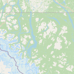
Map view of Nisutlin River Delta National Wildlife Area

Use this park location map to pinpoint Nisutlin River Delta National Wildlife Area in Canada, understand its exact geographic position, and read its mapped placement within the surrounding landscape more clearly.

Pigeon | © OpenStreetMap contributors

Location context for Nisutlin River Delta National Wildlife Area

Yukon
Park atlas

Compare surrounding northern wetlands, boreal reserves, and regional protected landscapes.

Parks Near Nisutlin River Delta National Wildlife Area and Regional Protected Areas

Explore other protected areas near Nisutlin River Delta National Wildlife Area to examine adjacent northern ecosystems and wetland reserves. Comparing connected habitats across the surrounding region reveals broader patterns in subarctic geography and migratory bird conservation.
National parkYukon
243 km away#1 closest

West

Kluane National Park and Reserve: Yukon National Park Protected Area and Landscape Geography

Explore mapped boundaries and regional context for this Yukon national park.

Kluane National Park and Reserve represents a vital protected national park within Yukon. This detail page focuses on its geographic identity and mapped features, offering insight into its regional landscape context and its role within the broader Canadian protected areas atlas. Discover the park's specific topography and its location within Yukon.

Area
22,013 km²
Established
1972
IUCN
II
Visitors
47.1K annual
Wildlife reserveAlaska
244 km away#2 closest

South

Kootznoowoo Wilderness: Coastal Rainforest and Island Protected Area Map in Alaska

A vast temperate wilderness within the Tongass National Forest

Kootznoowoo Wilderness stands as a landmark protected landscape in Southeast Alaska, spanning the majority of Admiralty Island. Its geography is characterized by towering old-growth conifers, fern-covered understories, and a rugged coastline carved by glacial forces. This wildlife reserve provides a vital refuge for dense brown bear populations and remains one of the most intact examples of a maritime temperate rainforest in North America.

Area
3,962.19 km²
Established
1980
IUCN
Ib
Relief
Mixed relief
National parkNorthwest Territories
271 km away#3 closest

Northeast

Nááts'ihch'oh National Park Reserve: Mapped Protected Landscape in Northwest Territories

Explore its geographic boundaries and regional context.

Gain a structured understanding of Nááts'ihch'oh National Park Reserve, a significant protected national park within the Northwest Territories. This detail provides context for its geographical placement and the extent of its protected landscape, vital for anyone exploring the region's natural areas through maps and atlas data.

Area
4,850 km²
Established
2014
IUCN
II
Visitors
109 annual
National parkNorthwest Territories
272 km away#4 closest

Northeast

Nahanni National Park Reserve National Park: Protected Landscape and Geographic Mapping

Explore the mapped terrain and protected area boundaries in Northwest Territories.

Navigate the protected landscape of Nahanni National Park Reserve, a designated national park within the Northwest Territories. This entry provides detailed insight into the park's mapped geographic boundaries and its role as a significant protected area. Understanding its place within the regional atlas allows for a deeper appreciation of its natural terrain and conservation significance, offering factual context for geographic exploration.

Area
30,050 km²
Established
1972
IUCN
II
Visitors
1.1K annual
National parkAlaska
About 314 km away#5 closest

Southwest

Glacier Bay National Park and Preserve: Alaska National Park Geographic Atlas

Mapped protected area context within Alaska's natural landscapes.

Glacier Bay National Park and Preserve serves as a vital protected landscape in Alaska, offering deep insights into regional geography and park boundaries. This detail page provides an atlas-centric view of the park, focusing on its role as a protected natural area and its unique position within the geographic tapestry of Alaska. Engage with structured data that illuminates the park's mapped terrain and its significance as a conservation landscape.

Area
13,045 km²
Established
1980
IUCN
V
Visitors
545.8K annual
State or regional parkBritish Columbia
321 km away#6 closest

Southeast

Denetiah Provincial Park and Protected Area: Regional Geography and Wilderness Mapping

An undisturbed boreal reserve in the Stikine Region

Discover the geographic structure of Denetiah Provincial Park and Protected Area, a vast roadless landscape in northern British Columbia. This park protects pristine boreal forests, elongated glacial lake basins, and critical river headwaters that serve as a benchmark for northern conservation within the Muskwa-Kechika Management Area.

Area
1,053.49 km²
Established
1999
IUCN
II
Relief
Upland
State or regional parkBritish Columbia
About 322 km away#7 closest

East

Horneline Creek Provincial Park: Protected Canyon Landscapes and Rocky Mountain Trench Geography

Remote glacial-terrace wilderness in northern British Columbia

Located deep in the Rocky Mountain Trench, Horneline Creek Provincial Park is defined by its deep-cut canyon and ancient glacial terraces. This protected area offers an intimate view of sub-boreal terrain where mineral-stained walls and aspen-dotted grasslands create a concentrated, ecologically significant landscape within a remote corner of northern British Columbia.

Area
2.98 km²
Established
1999
IUCN
II
Relief
Upland
Nature reserveBritish Columbia
About 357 km away#8 closest

Southeast

Gladys Lake Ecological Reserve: Remote Wilderness and Alpine Geography in British Columbia

Scientific reference area on the Spatsizi Plateau

Explore the expansive geography of Gladys Lake Ecological Reserve, a major protected area located in the remote interior of British Columbia. This reserve provides a strictly preserved natural landscape defined by high-elevation ridges, subalpine transitions, and the pristine wilderness of the Eaglenest Range, serving as a benchmark for ecological research in Canada.

Area
440.98 km²
Established
1975
IUCN
Ia
Relief
Mountain

Common questions about visiting, size, designation, and location context for Nisutlin River Delta National Wildlife Area

Nisutlin River Delta National Wildlife Area FAQs for park facts, access, geography, and protected area context

Find quick answers about Nisutlin River Delta National Wildlife Area, including protected-area facts, park geography, trail and visitor context, and how the park fits into its surrounding country and regional landscape.
MoriAtlas Explorer

Continue Your Protected Areas Search Across the Global Atlas

Deepen your exploration by continuing the structured search for national parks and protected areas worldwide. Utilize the comprehensive filtering capabilities to compare different conservation landscapes and refine your understanding of global park geography. Discover more about the distribution and characteristics of protected natural areas.

Global natural geography