

Mori Atlas logo
National parkOrgan Pipes National Park

Discover the dramatic columnar basalt formations and ancient terrains of this protected landscape near Melbourne.

Organ Pipes National Park: Victoria's Premier National Park for Geological Discovery and Basalt Landscape

Organ Pipes National Park, located northwest of Melbourne, Australia, offers a unique window into geological time and the raw beauty of volcanic landscapes. This protected national park features extraordinary columnar basalt formations, exposed through erosion along Jacksons Creek, which stand as a testament to Victoria's recent volcanic past. Explore the mapped terrain and distinct geology of this significant protected area, showcasing ancient Silurian sediments beneath relatively young lava flows, providing profound insights into regional geography and landscape evolution.

columnar basaltvolcanic geologyVictoria national parkgeological monumentbasalt plainsIUCN Category III

Organ Pipes National Park

National park

Park overview

Structured park overview, official facts, and landscape profile for Organ Pipes National Park

Organ Pipes National Park park facts, protected area profile, and essential visitor context

Review the core facts for Organ Pipes National Park, including designation, size, terrain, visitor scale, habitats, and operating context in one park-focused overview.

About Organ Pipes National Park

Organ Pipes National Park occupies a distinctive position among Victoria's protected areas as a geological monument that also supports significant ecological communities. The park's core feature, the Organ Pipes themselves, formed when massive lava flows from nearby volcanoes (near present-day Sunbury) spread across the Keilor Plains during the Pleistocene epoch. As these basalt lava flows cooled over time, the outer surface contracted and cracked in a characteristic hexagonal pattern, creating the columnar structures now visible along Jacksons Creek. The creek's subsequent erosion over the past one to two million years has progressively exposed these formations, revealing walls of columnar basalt rising approximately 20 meters. Each column measures roughly one meter in width, with most standing vertically while smaller surrounding columns may be inclined or horizontal. The geological significance extends beneath the surface, where the valley floor exposes a buried ancient creek valley cut into 400-million-year-old Silurian mudstones and sandstones, containing gravel deposits from those prehistoric water courses. Above this ancient terrain, marine fossils within the Silurian sedimentary rocks confirm that this region was once submerged beneath a prehistoric sea. The park's relatively small size (121 hectares) belies its importance as an outdoor laboratory for understanding volcanic geology, geological time scales, and successful ecosystem restoration.

Quick facts and research context for Organ Pipes National Park

Organ Pipes National Park covers 121 hectares in central Victoria, Australia, situated in the Maribyrnong River catchment northwest of Melbourne. The park was established on March 12, 1972, initially with 65 hectares donated by the E.A. Green Charitable Foundation, later expanded through additional land acquisitions in 1978 and 1997. The defining geological features are the Organ Pipes, a series of vertically standing hexagonal basalt columns rising up to 20 meters high, formed as lava cooled and contracted approximately one million years ago. Jacksons Creek, a tributary of the Maribyrnong River, has carved a deep gorge through the basalt plain, exposing these columnar formations and other geological features including Tessellated Pavement and Rosette Rock. The park lies in a rain shadow area receiving approximately 580 millimeters of annual rainfall, predominantly during winter and spring months.

Protection and recognition

Exploring terrestrial conservation frameworks and official historical designation records

Organ Pipes National Park Protected Area Status and Designation History

Natural area explorers can verify the documented terrestrial protection status and conservation management scope established for Organ Pipes National Park in 1977. Reviewing historical designation records and official conservation frameworks offers essential geographic context for understanding protected natural landscapes.

Protection details

Protection scope
Terrestrial
Designated year
1977
Park context

Deeper park guide and search-rich context for Organ Pipes National Park

Organ Pipes National Park history, landscape, wildlife, and travel context

Explore Organ Pipes National Park through its history, landscape character, ecosystems, wildlife, conservation priorities, cultural context, and seasonal travel timing in a structured park guide built for atlas discovery and search intent.

Why Organ Pipes National Park stands out

Organ Pipes National Park is best known for its extraordinary columnar basalt formations, the Organ Pipes, which represent the finest example of columnar jointing in Victoria. These vertical hexagonal columns, formed as cooling lava contracted and cracked, create a striking visual display resembling organ pipes stacked together. Beyond the Organ Pipes, the park protects related geological features including Tessellated Pavement where basalt has fractured into regular tile-like patterns, and Rosette Rock where columns radiate outward like wheel spokes. The park also preserves a rare glimpse into Victoria's geological history, with 400-million-year-old Silurian marine sedimentary rocks and fossils (including graptolites) exposed beneath the volcanic basalt, demonstrating that this area once lay beneath a prehistoric ocean. The contrast between these ancient marine sediments and the relatively recent volcanic overlayer makes the park a living geological classroom.

Organ Pipes National Park history and protected-area timeline

The land that now constitutes Organ Pipes National Park has a layered human history extending back thousands of years. The earliest documented inhabitants were the Australian Aboriginal Woiwurrung people of the Kulin Nation, who lived in the Yarra and Maribyrnong River valleys, with Jackson Creek forming a boundary between the Marin-Bulluk and Wurundjeri-Willam clans. These traditional owners practiced controlled burning to maintain grasslands and harvest native grasses and spear grass, coexisting with wildlife including kangaroos, dingoes, platypuses, and numerous bird species. European settlement began in the early 19th century, with settlers from Tasmania introducing exotic plants and animals and converting land for agriculture. By the mid-19th century, a small hamlet existed near the Organ Pipes, served by a suspension bridge across Jacksons Creek. The Hall family lived in the area from 1870 to the 1920s, operating plum orchards whose trees still exist today. Later residents included the Bartlett family (1934-1948) and E.A. Green, whose estate was donated to establish the national park. Environmental degradation from European land use prompted conservation action, leading to the park's declaration on March 12, 1972, as Victoria's first national park created through private land donation. The Friends of Organ Pipes (FOOOPS), established as Australia's first park friends group, has supported rehabilitation efforts since the park's creation.

Organ Pipes National Park landscape and geographic character

The physical landscape of Organ Pipes National Park centers on the deeply incised valley of Jacksons Creek, which has cut through the basalt plains to create a gorge exposing the park's geological treasures. The surrounding Keilor Plains consist of flat to gently undulating terrain formed from ancient lava flows, part of the Western Volcanic Plains that extend across western Victoria and into southeastern South Australia, representing the third largest lava plains system in the world. The valley walls reveal the layered geological history, with dark grey-brown basalt forming the dominant rock type and exposing the columnar Organ Pipes formation. Above the creek, the landscape supports remnant grassland communities that once covered much of the basalt plains before agricultural conversion. The park's soils reflect the underlying geology, with volcanic soils derived from basalt dominating the valleys, including red-brown earths with low permeability, grey duplex soils in flatter areas, and alluvial soils along the creek corridor capable of supporting river red gum woodland. The overall terrain is relatively constrained within the gorge, with the park's 121 hectares centered on the creek corridor and adjacent slopes.

Organ Pipes National Park ecosystems, habitats, and plant life

The ecological character of Organ Pipes National Park reflects its position on the basalt plains of central Victoria, a landscape that historically supported extensive grassy woodlands and grasslands before European agricultural expansion. Since the park's establishment, extensive rehabilitation has transformed previously degraded land dominated by weeds such as thistles and boxthorn into thriving indigenous vegetation communities. The re-vegetation program, conducted over more than three decades with support from the Friends of Organ Pipes, has established approximately 124 indigenous plant species, including more than 20 species classified as rare, threatened, or significant. Vegetation communities include basalt plain grassland with species such as kangaroo grass, windmill grass, redleg grass, and wallaby grasses, as well as riparian woodland along Jacksons Creek featuring river red gum, manna gum, and blackwood. The park also supports reed beds, sedgeland, and shrubland communities. The restoration has created diverse habitat layers, from ground-layer grasses through to canopy trees, supporting a correspondingly diverse fauna community.

Organ Pipes National Park wildlife and species highlights

Organ Pipes National Park supports a surprising diversity of wildlife given its relatively small size, with documented populations including 15 native mammal species, 88 bird species, 13 reptile species, and 6 amphibian species. Mammals include eastern grey kangaroos and swamp wallabies that are commonly observed, particularly during dawn and dusk hours when they emerge from shelter to feed in the grasslands. The park has been the focus of successful biodiversity projects, including a long-running bat roosting box program that has resulted in bats being the most diverse group of native mammals recorded. The sugar glider, which was present in the park historically but had disappeared, was reintroduced in 1989 from nearby Toolern Vale as part of conservation efforts. Reptiles found in the park include the long-necked tortoise, eastern bearded dragon, and red-bellied black snake, while amphibians include the growling grass frog. Birdlife is particularly diverse, with species including the wedge-tailed eagle soaring above the gorge, and numerous smaller birds inhabiting the woodland and grassland habitats. The creek supports fish species including the mountain galaxias, demonstrating the aquatic habitat value of Jacksons Creek.

Organ Pipes National Park conservation status and protection priorities

Organ Pipes National Park holds significant conservation value both geologically and ecologically, recognized through its IUCN Category III designation as a Natural Monument within the United Nations' system of national parks and protected areas. The primary conservation focus is preserving the outstanding geological features including the Organ Pipes, Tessellated Pavement, and Rosette Rock, which represent Victoria's best examples of columnar basalt formations and related volcanic structures. Beyond geology, the park serves as a conservation center for the endangered basalt plain grassland ecosystem, one of Victoria's most threatened vegetation types. The re-vegetation program has been particularly successful in restoring indigenous vegetation and creating habitat for native wildlife, with 124 indigenous plant species now recorded including over 20 rare or threatened species such as the button wrinklewort (Rutidosis leptorrhynchoides). The park also protects significant populations of Callitris glaucophylla (white cypress-pine), one of only two remaining stands near Melbourne. Management focuses on weed control, rabbit management, erosion control, and maintaining the ecological integrity of both the geological formations and the surrounding landscape.

Organ Pipes National Park cultural meaning and human context

The cultural context of Organ Pipes National Park encompasses both Aboriginal heritage and European settlement history. The Woiwurrung people of the Kulin Nation have traditional connections to the Maribyrnong River valley, with Jackson Creek serving as a clan boundary between Marin-Bulluk and Wurundjeri-Willam territories. Archaeological evidence including campsites and isolated artifacts within the park demonstrates the long-term Aboriginal occupation and use of the area for resources including native grasses and wildlife. European settlement beginning in the early 19th century brought dramatic landscape changes through introduction of exotic species, agricultural conversion, and vegetation clearance. The historical hamlet near the Organ Pipes, served by a suspension bridge across Jacksons Creek, reflects the European settlement pattern before the land was dedicated to conservation. The park's establishment in 1972 marked a significant conservation milestone in Victoria, being the first national park created through private land donation and the first to have an organized friends group supporting its management. The park serves educational purposes in interpreting both geological processes and human history.

Top sights and standout views in Organ Pipes National Park

Organ Pipes National Park offers visitors the opportunity to observe spectacular geological formations including the namesake Organ Pipes, vertical hexagonal basalt columns rising dramatically from the creek bed, the Tessellated Pavement with its tile-like fractured surface, and the radial Rosette Rock formation. Walking tracks descend from the visitor center through restored grassland to the creek and rock features, with early morning or dusk visits offering最佳 chances to see kangaroos and wallabies. The park provides environmental education through its visitor center, which interprets the volcanic geology, Aboriginal history, European settlement, and restoration program. The successful ecological rehabilitation demonstrates how degraded land can be restored to support indigenous biodiversity, with the park now supporting over 120 indigenous plant species and diverse wildlife. The geological significance, with rocks ranging from 400 million years old (Silurian marine sediments) to 2.8 million years old (Pleistocene volcanic basalt), makes the park a unique window into geological time.

Best time to visit Organ Pipes National Park

Organ Pipes National Park can be visited throughout the year, though spring and autumn offer the most comfortable conditions for exploring the outdoor tracks and appreciating the park's geological and ecological features. Winter and early spring (June to October) bring the majority of the annual rainfall, creating green grassland conditions but potentially making some tracks muddy and slippery. The summer months (December to February) can be warm, though the gorge provides some shade along the creek. Early morning visits are particularly rewarding for wildlife viewing, as kangaroos and wallabies are most active during dawn and dusk hours. The park remains open year-round, though visitors should be aware that aircraft noise from nearby Melbourne Airport and occasional motorsport noise from Calder Park Raceway are part of the sonic environment. The visitor center provides information about current conditions and any access restrictions.
Monthly climate preview

Tracking annual temperature gradients and daily precipitation cycles at Organ Pipes National Park

Organ Pipes National Park Climate Normals and Monthly Weather Patterns

Long term meteorological records at the representative coordinate of 267.1 meters elevation show average monthly temperatures between 7 and 20 degrees Celsius with stable rainfall patterns throughout the year. Comprehensive monthly climate profiles reveal extreme temperature thresholds exceeding 39 degrees Celsius alongside precise daily precipitation metrics for deeper geographic comparison.
Annual mean13 °C
7 °C20 °C
Jan20°
Feb20°
Mar17°
Apr14°
May10°
Jun
Jul
Aug
Sep10°
Oct13°
Nov15°
Dec18°
Warmest month
January

20 °C

Coolest month
July

7.1 °C

Wettest month
June

2.3 mm/day

Driest month
March

1.4 mm/day

Park location guide

Geography guide, regional context, and park location map for Organ Pipes National Park

Organ Pipes National Park park geography, regions, and map view in Australia

Understand where Organ Pipes National Park sits in Australia through a broader geographic reading of the surrounding landscape, nearby location context, and its mapped position within the national park landscape.

How Organ Pipes National Park fits into Australia

Australia is a constitutional monarchy and federal parliamentary democracy comprising six states and ten territories. With a population of nearly 28 million, it is one of the world's most urbanised countries, with most people concentrated on the eastern seaboard. The country has a high Human Development Index and is known for its cultural diversity, ancient Aboriginal heritage, and unique wildlife.

Wider geography shaping Organ Pipes National Park in Australia

Australia occupies the entire Australian continent, the island of Tasmania, and numerous smaller islands. It is the world's flattest and driest inhabited continent, featuring vast deserts in the interior (the Outback), tropical rainforests along the eastern coast, and a coastline bordering the Indian and Pacific Oceans.

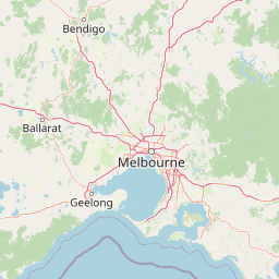
Map view of Organ Pipes National Park

Use this park location map to pinpoint Organ Pipes National Park in Australia, understand its exact geographic position, and read its mapped placement within the surrounding landscape more clearly.

Pigeon | © OpenStreetMap contributors
Recorded earthquake history

View Recorded Seismic Activity Near Organ Pipes National Park

Examine the historical record of earthquakes documented in the vicinity of Organ Pipes National Park. MoriAtlas provides a structured summary of seismic events to help you better understand the regional geological history of this protected area.

Organ Pipes National Park Earthquake History

Catalogued events

3 events

Strongest magnitude

Magnitude 4.2

Most recent event

May 28, 2023

This history includes earthquakes recorded inside the park or within 50 km of its borders

Park atlas

Explore other protected areas, mapping their geographic spread and unique features across Victoria's landscapes, from volcanic plains to river corridors.

Compare National Parks and Protected Areas Near Organ Pipes National Park in Victoria

After exploring the unique columnar basalt of Organ Pipes National Park, you can browse a curated list of nearby protected areas and national parks across central Victoria. This geographic overview helps you compare diverse protected landscapes, trace connections between volcanic plains and river systems, and understand broader conservation efforts.
National parkAustralia
39 km away#1 closest

Northeast

Kinglake National Park: Protected Mountain Ash Forests and Geological Heritage

Explore the mapped landscape and regional geography of this Australian National Park.

Kinglake National Park is a significant protected natural area in Victoria, Australia, distinguished by its mountainous terrain dominated by eucalyptus forests, including towering mountain ash trees. The park's unique geology features sedimentary layers with marine fossils, offering a glimpse into its ancient submerged history. This National Park provides a rich environment for exploring diverse landscapes, understanding fire ecology, and appreciating the mapped boundaries of a resilient natural area.

Area
232.1 km²
Established
1928
IUCN
II
Relief
Upland
National parkAustralia
39 km away#2 closest

West

Brisbane Ranges National Park: Mapped Protected Terrain and Wildlife Observation

Explore its landscape context and geographic identity.

Brisbane Ranges National Park offers a protected natural landscape west of Melbourne, known for its accessible bushland scenery and wildlife observation opportunities. As a national park, it preserves a unique region of forested gullies and moderate elevation hills, providing valuable insight into Victoria's geographic diversity. Explore the mapped terrain, understand the park's role as a protected area, and discover the features that make it a distinct component of Australia's natural atlas.

Area
77.18 km²
Established
1973
IUCN
II
Relief
Upland
National parkAustralia
50 km away#3 closest

East

Dandenong Ranges National Park: A Protected National Park Landscape

Explore its mapped terrain and regional geographic context.

Dandenong Ranges National Park represents a significant protected area near Melbourne, Australia, characterized by its steep, undulating ridges and deep gullies supporting tall, wet forests. As a national park, it safeguards a vital natural landscape, providing context for regional geography and offering insights into its terrain. This entry facilitates detailed exploration of the park's protected boundaries and its place within the Australian protected-area atlas.

Area
35.4 km²
Established
1987
IUCN
II
Visitors
1M annual
National parkAustralia
50 km away#4 closest

Southeast

Churchill National Park: Remnant Woodland and Industrial Heritage in Victoria, Australia

Mapped protected area with notable bird diversity and historical quarry sites.

Churchill National Park offers a unique glimpse into Victoria's remnant woodland ecosystems and early twentieth-century industrial history. As a national park, it protects critical habitats for a variety of bird species and preserves the landscape features of historical quarrying operations, including the Scoresby Tramway ruins. The park's mapped geography and accessible walking tracks, like the Channel Track, provide opportunities for exploration and understanding its role as a protected natural and historical asset near Melbourne.

Area
2.71 km²
Established
1941
IUCN
II
Relief
Upland
National parkAustralia
65 km away#5 closest

East

Yarra Ranges National Park: Victoria's Towering Mountain Ash Forests and Protected Landscape Geography

Explore mapped boundaries and vital water catchment landscapes.

Yarra Ranges National Park in Victoria, Australia, represents a significant protected landscape within the Great Dividing Range. It is renowned for its exceptionally tall mountain ash forests, which are vital carbon stores and habitats, and its critical function as a water catchment area for Melbourne. This park offers a deep dive into a unique geographic setting defined by diverse mountain terrain, temperate rainforests, and subalpine environments, all preserved for their ecological and water security importance.

Area
760 km²
Established
1995
IUCN
II
Visitors
800K annual
National parkAustralia
About 70 km away#6 closest

South

Point Nepean National Park: Protected Coastal Landscape & Geographic Context

Discover the mapped boundaries of this Australian national park.

Point Nepean National Park represents a vital protected landscape situated at the southern extremity of the Mornington Peninsula, Australia. This national park encompasses a rugged headland that forms the critical entrance to Port Phillip Bay, characterized by striking limestone cliff formations and coastal ecosystems. As a site of historical military importance, Point Nepean National Park offers a distinct geographic identity and a unique protected area for atlas-based exploration and understanding its regional context.

IUCN
II
National parkAustralia
72 km away#7 closest

South

Mornington Peninsula National Park: Victoria's Coastal Protected Landscape and Map Atlas

Explore dramatic cliff-top terrain, sandy beaches, and native bushland.

Mornington Peninsula National Park is a protected natural area defined by its spectacular coastal geography in Victoria, Australia. The park features striking cliff-top vistas, extensive sandy beaches, and sculpted dunes that showcase the dynamic forces shaping Australia's coastline. Its mapped boundaries protect a vital landscape including areas like Greens Bush, offering a glimpse into the region's native vegetation and geological formations for those interested in detailed geographic context and protected area exploration.

Area
26.86 km²
Established
1995
IUCN
II
Relief
Mixed relief
Watercolor painting of green trees, rolling hills, and a pastel sky.
National parkAustralia
79 km away#8 closest

North

Heathcote-Graytown National Park: Protected Box-Ironbark Forests and Swift Parrot Habitat

Mapping the landscape and geography of this Australian National Park.

Heathcote-Graytown National Park is a significant protected area safeguarding one of Victoria's remaining box-ironbark forest ecosystems. Its landscape, nestled within the Great Dividing Range, provides essential habitat for migratory swift parrots and supports diverse woodland bird species recognized by BirdLife International. Explore the park's mapped terrain and understand its role within the Central Highlands' regional geography as a vital conservation landscape.

Area
128.33 km²
Established
2002
IUCN
II
Relief
Mountain

Common questions about visiting, size, designation, and location context for Organ Pipes National Park

Organ Pipes National Park FAQs for park facts, access, geography, and protected area context

Find quick answers about Organ Pipes National Park, including protected-area facts, park geography, trail and visitor context, and how the park fits into its surrounding country and regional landscape.
MoriAtlas Explorer

Continue Your Protected Areas Search Across the Global Atlas

Deepen your exploration by continuing the structured search for national parks and protected areas worldwide. Utilize the comprehensive filtering capabilities to compare different conservation landscapes and refine your understanding of global park geography. Discover more about the distribution and characteristics of protected natural areas.

Global natural geography