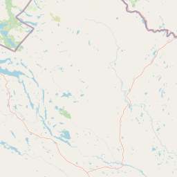
Lakes
Jierttáluoppal
693 m

Structured data detailing the mountainous terrain, alpine habitat, and regional extent.
This geographic profile details the physical characteristics of Øvre Dividal National Park situated within the Målselv Municipality of Troms. The protected area spans 750 square kilometers, featuring a rugged mountain landscape that transitions from boreal forest and tundra to expansive alpine meadows. Key natural features include peaks such as Kistefjellet, Flatfjellet, and Jerta across a 31 kilometer north-south span.
Related tags
Arctic alpine wilderness in Norway's second-driest valley
Øvre Dividal National Park is a protected wilderness area in northern Norway, established in 1971 to preserve a largely undisturbed inland valley and mountain landscape in Målselv Municipality of Troms county. The park covers approximately 750 square kilometers of Arctic alpine terrain, spanning elevations from roughly 300 meters to 1,600 meters above sea level. The park protects a remarkable ecological gradient, where pine forests at the lowest elevations give way to mountain birch woodlands, then to willow and dwarf birch shrubland on open alpine tundra. This vertical zonation creates diverse habitats within a relatively compact area. The park's name reflects its geography—'Dividal' derives from the Divi River, with the Norwegian 'øvre' meaning 'upper', signifying the upper part of the Dividal valley. The Northern Sami name, Dieváidvuovddi álbmotmeahcci, connects to the region's indigenous heritage. The park forms part of a larger wilderness complex that extends into neighboring Sweden, representing one of Scandinavia's most pristine inland mountain environments.
Administrative boundaries in Målselv Municipality and Troms
Øvre Dividal’s mapped park boundary covers 750 km²
Mountain relief range spanning from 300 to 1600 meters
Lakes
693 m
Streams
Valleys
Lakes
777 m
Peaks
1,428 m
Rivers
Analysis of subpolar relief, forest cover, and diverse mountain habitats
Mountains · Valleys · Forest
Boreal forest · Montane forest · Alpine meadow · Tundra habitat
Trace the surrounding Arctic alpine wilderness and explore regional protected landscapes of Northern Norway.
West

Explore its mapped terrain, canyon, and alpine ecosystems.
Rohkunborri National Park offers a profound encounter with northern Norway's wild geography. As a designated national park in Troms county, it features the iconic Sørdalen canyon, a dominant geological feature that shapes its diverse terrain. The park's landscape encompasses a rich ecological gradient, from boreal forests to alpine tundra, supporting a variety of wildlife. This protected area is crucial for understanding Scandinavian mountain ecosystems and transboundary conservation efforts, providing rich content for atlas-based exploration of its mapped boundaries and natural context.
West

Northernmost National Park in Norrbotten County, Sweden
Vadvetjåkka National Park offers a unique atlas perspective on Sweden's northernmost protected mountain landscape. Explore its remote Arctic terrain, characterized by glaciers existing at unusual low altitudes and significant karst cave systems carved into limestone bedrock. This is a vital point for understanding the mapped geography and protected natural features of Norrbotten County and Swedish Lapland.
Southwest
Subarctic national park with unique landscapes
Abisko National Park in Swedish Lapland offers a glimpse into dramatic subarctic terrain. Explore its protected boundaries, river canyons, and alpine tundra through structured geographic data.
Northeast
Subarctic terrain and geographic context in Troms, Norway.
MoriAtlas offers detailed geographic context for Reisa National Park, a protected landscape in Norway's Troms county. Explore the park's identity as a significant subarctic river valley, carved by the Reisa River into a dramatic canyon system. This page provides insights into its mapped natural features, regional landscape setting, and its importance within the broader atlas of protected areas. Understand the park's protected boundaries and terrain for structured geographic discovery.
Northwest
Norway's protected area within the Senja region.
Delve into the detailed protected landscape of Ånderdalen National Park, a national park located on Norway's Senja island. This entry offers a focused atlas exploration of its unique geographic features, including its celebrated ancient coastal pine forest, dramatic glacial valleys carved from granite, and its significance as a representative example of the northern Norwegian coastal mountain terrain. Understand the mapped boundaries and the natural context of this vital conservation area.
Southwest
Explore mapped terrain and regional geography.
Stora Sjöfallet National Park stands as a significant protected landscape within Norrbotten County, Sweden, renowned for its striking Arctic mountain scenery centered on the Áhkká massif. As a key component of the Laponian Area UNESCO World Heritage Site, its vast expanse of over 1,278 square kilometers offers critical insights into subarctic ecosystems, glacial terrain, and the mapped boundaries of a protected natural territory. Discover the unique geographic features and ecological value of this expansive national park.
Southwest
Explore the mapped geography of Norrbotten County's largest alpine national park.
Sarek National Park represents the heart of Sweden's alpine wilderness, a protected landscape defined by its towering mountain peaks, expansive glaciers, and deeply carved glacial valleys. Situated in Norrbotten County, the park's geography is characterized by a remote and rugged terrain, making it a prime destination for understanding high-altitude natural environments through mapped context. Discover the unique contours of this iconic national park and its place within the broader regional geography of Swedish Lapland.

North
Mapped terrain, fjord basins, and mountain catchment zones
Skipsfjord landskapsvernområde represents a compact, biologically diverse corridor on the island of Vanna. This protected landscape encompasses the salmon-rich Skipsfjordelva, expansive mire systems, and coastal shorelines that document a transition from historical agricultural use to undisturbed natural conservation. Explore the precise geography and environmental character of this significant northern protected area.
Deepen your understanding of Øvre Dividal National Park by continuing to explore its specific geographic features, mapped terrain, and protected area context. This detailed atlas entry serves as a gateway to appreciating the unique Arctic alpine wilderness and its place within the broader landscape of Troms, Norway, highlighting its ecological significance and conservation value.