

Mori Atlas logo
National parkPa Hin Ngam National Park

Discover mapped park boundaries within the natural terrain of Chaiyaphum Province, Thailand.

Pa Hin Ngam National Park: Protected Landscape and Geographic Context in Chaiyaphum

Pa Hin Ngam National Park represents a distinct protected landscape within Chaiyaphum Province, Thailand. This national park serves as a key reference for understanding protected area distribution and regional geographic context in northeastern Thailand. Explore its mapped boundaries and the surrounding natural terrain to gain a structured appreciation of its place within the country's conservation landscapes.

National ParkRock FormationsWildflower FieldsThailandMountain ViewsSeasonal Blooms

Pa Hin Ngam National Park

National park

Park overview

Structured park overview, official facts, and landscape profile for Pa Hin Ngam National Park

Pa Hin Ngam National Park park facts, protected area profile, and essential visitor context
Review the core facts for Pa Hin Ngam National Park, including designation, size, terrain, visitor scale, habitats, and operating context in one park-focused overview.

About Pa Hin Ngam National Park

Pa Hin Ngam National Park occupies a transitional ecological zone where the forested slopes of the Dong Phaya Yen Mountains meet the semi-arid Khorat Plateau. This geographic position creates a landscape of considerable variety, from steep forested ridges to open grass savannah and seasonal wetlands. The park's most distinctive feature is the network of weathered rock formations scattered across its western reaches, where centuries of erosion have produced towering boulders and strange sculptural shapes that give the park its name meaning beautiful stone forest. Beyond the rock formations, the park encompasses the headwaters of several streams that flow outward to join either the Chao Phraya system to the west or the Mekong system to the east, making this a critical watershed area. The landscape around the park has been shaped by both geological forces and the seasonal monsoon climate, resulting in vegetation patterns that shift dramatically between the dry and wet seasons. The park's relative accessibility from major population centers in northeastern Thailand has made it a popular destination for domestic tourism, particularly during the July and August flowering season when the Siam tulips are in bloom.

Quick facts and research context for Pa Hin Ngam National Park

Pa Hin Ngam National Park spans roughly 100 square kilometers in the Thep Sathit district of Chaiyaphum Province. The park sits at the geographic transition between the Dong Phaya Yen Mountains and the Khorat Plateau. Its highest point reaches 846 meters at the Sut Phan Din viewpoint, which offers panoramic views into the Sonthi River valley. The park is managed by Thailand's Department of National Parks, Wildlife and Plant Conservation and received approximately 106,000 visitors in 2019. The name refers to the distinctive weathered rock formations that are the park's most recognizable feature.

Park context

Deeper park guide and search-rich context for Pa Hin Ngam National Park

Pa Hin Ngam National Park history, landscape, wildlife, and travel context
Explore Pa Hin Ngam National Park through its history, landscape character, ecosystems, wildlife, conservation priorities, cultural context, and seasonal travel timing in a structured park guide built for atlas discovery and search intent.

Why Pa Hin Ngam National Park stands out

Pa Hin Ngam is best known for two defining natural features. The first is the collection of bizarrely eroded rock formations at Lan Hin Ngam, where erosion has carved large boulders into shapes resembling nails, radar dishes, hens, and other objects. The second is the seasonal display of Siam tulip flowers (Curcuma alismatifolia), known locally as Dok Kra Jiao, which bloom in purple profusion across the Bua Sawan Field during the rainy season. The park's 846-meter Sut Phan Din viewpoint provides one of the most dramatic cliff-edge vistas in northeastern Thailand, looking out over a valley that marks the watershed between Thailand's two major river systems.

Pa Hin Ngam National Park history and protected-area timeline

The area that now comprises Pa Hin Ngam National Park has been known to local communities for generations, with the strange rock formations serving as a landmark and gathering place long before any formal protection was considered. In 1985, the Tep Satit Forestry Department conducted the first official survey of the area and recommended its preservation due to its unique geological features and ecological significance. The initial protected status came in October 1986, when a small 10-square-kilometer area surrounding the rock formations was declared a protected park. This initial designation reflected the immediate concern to preserve the most visually spectacular portion of the area. In 1993, the Forestry Department of Thailand undertook a more comprehensive survey that included the surrounding forested landscapes and recommended expansion to full national park status. The national park covering approximately 100 square kilometers (62,437 rai) was officially created on September 19, 1994, though the formal gazettment process was not completed until 2007.

Pa Hin Ngam National Park landscape and geographic character

The terrain of Pa Hin Ngam National Park is characterized by a series of north-south trending ridges and valleys that form part of the Phang Hoei mountain range. The most dramatic topographic feature is the steep cliff at Sut Phan Din, the park's highest point at 846 meters above sea level, where the land drops away sharply into a deeply incised valley. This cliff marks a visual and ecological boundary, creating a landscape of considerable scenic drama. The rock formations at Lan Hin Ngam represent the park's most unusual terrain, where massive boulders of weathered granite and sandstone have been shaped by erosional processes into a maze of pinnacles, overhangs, and oddly configured stones. Between the rocky ridges, seasonal streams have carved small valleys that support riparian vegetation and provide drainage pathways for the monsoon rains. The vegetation cover varies from dense evergreen forest on the higher slopes to more open dipterocarp woodland on the lower terrain, creating a mosaic of forest types that reflects the topographic and moisture gradients across the park.

Pa Hin Ngam National Park ecosystems, habitats, and plant life

The ecological character of Pa Hin Ngam reflects its position at the intersection of two major biogeographic regions. The park supports a mixture of tropical evergreen forest in the valleys and on north-facing slopes, while the ridges and drier areas carry dipterocarp woodland that becomes semi-deciduous during the dry season. The seasonal timing of rainfall strongly influences the park's ecology, with the monsoon months bringing renewed growth and flowering across many plant communities. The Siam tulip fields represent one of the most visually spectacular botanical displays in the region, with the purple-flowered Curcuma alismatifolia forming dense colonies in the open grasslands during July and August. The dipterocarp forests also flower prominently at the onset of the rainy season, with many species producing showy purple or white blooms that attract a variety of pollinators. Beyond the flowering plants, the park contains a range of forest types that provide habitat for numerous bird and mammal species, though the park is not known for any particularly rare or endemic species.

Pa Hin Ngam National Park wildlife and species highlights

While Pa Hin Ngam is not primarily known as a wildlife destination, the park's varied habitat types support representative assemblages of northeastern Thailand's fauna. The mixed forest environments provide suitable habitat for several species of pheasants, parakeets, and other forest-dwelling birds that are characteristic of the region. The more open dipterocarp woodlands and grassland areas support populations of larger mammals including various species of deer and wild pig, though these animals are typically shy and difficult to observe. The rocky formations offer potential shelter for several species of bats and small mammals that utilize the crevices and caves within the boulder fields. The streams and seasonal water features support populations of fish and amphibians that are typical of the region's freshwater environments. The park's status as a protected area has helped maintain these wildlife populations despite the surrounding agricultural landscape, though the park's relatively small size limits the extent of its conservation value for larger ranging species.

Pa Hin Ngam National Park conservation status and protection priorities

Pa Hin Ngam National Park represents an important protected area within Thailand's northeastern region, though its conservation significance is somewhat limited by its relatively small size and the surrounding matrix of agricultural land. The park's primary conservation value lies in its watershed function, protecting the headwater catchments that feed streams flowing to both the Chao Phraya and Mekong river systems. The protection of the rock formations and surrounding forest also preserves an area of scenic and geological interest that might otherwise be subject to resource extraction or development pressure. The park's floral communities, particularly the seasonal Siam tulip displays, represent a conservation target of local importance, though the species involved are not considered globally threatened. Management by the Department of National Parks focuses on visitor access control, fire prevention during the dry season, and maintenance of the trail systems that allow public enjoyment of the park while minimizing environmental impact.

Pa Hin Ngam National Park cultural meaning and human context

The area now within the park has been part of the cultural landscape of northeastern Thailand for generations, with the distinctive rock formations serving as a well-known landmark in the region. The local Thai communities in the surrounding area have traditional relationships with the land that include seasonal gathering of forest products and use of the area for religious and ceremonial purposes. The naming of the park in Thai reflects the cultural significance of the rock formations, with Hin Ngam (beautiful stone) describing the aesthetic appreciation of these natural features that has persisted in local knowledge. The park's location on the traditional boundary between the central and northeastern regions of Thailand gives it some cultural significance as a geographic landmark marking regional transitions.

Top sights and standout views in Pa Hin Ngam National Park

The rock formations at Lan Hin Ngam remain the park's signature attraction, where erosion has created a landscape of bizarrely shaped boulders that inspire imaginative interpretations and provide excellent photographic opportunities. The seasonal display of Siam tulips at Bua Sawan Field during the July to September rainy season draws visitors seeking to experience one of northeastern Thailand's most spectacular wildflower displays. The Sut Phan Din viewpoint at 846 meters offers one of the region's most impressive panoramic vistas, with the cliff dropping away to reveal the valley below and the distant mountains of the Dong Phaya Yen range. The three-tiered Thep Phana waterfall provides a refreshing destination during the wet season when water flows strongly through the park's drainage systems.

Best time to visit Pa Hin Ngam National Park

The optimal time to experience Pa Hin Ngam National Park coincides with the rainy season from July through September, when the Siam tulip flowers are in bloom across the Bua Sawan Field and the dipterocarp forests are flowering. This period transforms the park's appearance with purple floral displays and lush green vegetation following the onset of the monsoon. The waterfall also flows most reliably during these months. The dry season from November through April offers clearer skies and more comfortable hiking conditions, though the landscape is browner and the waterfall may have reduced or no flow. The park can be visited year-round, but visitors seeking the signature flower displays should plan their trip for July or August.
Park location guide

Geography guide, regional context, and park location map for Pa Hin Ngam National Park

Pa Hin Ngam National Park park geography, regions, and map view in Thailand
Understand where Pa Hin Ngam National Park sits in Thailand through a broader geographic reading of the surrounding landscape, nearby location context, and its mapped position within the national park landscape.

How Pa Hin Ngam National Park fits into Thailand

Thailand is a Southeast Asian nation formerly called Siam, located in mainland Southeast Asia. It operates as a unitary parliamentary constitutional monarchy under King Vajiralongkorn. The country borders Myanmar, Laos, Cambodia, and Malaysia, with maritime boundaries involving Vietnam, Indonesia, and India. Thailand has a population of nearly 66 million and covers approximately 513,120 km². Historically, the Sukhothai Kingdom marks the beginning of Thai history, followed by the powerful Ayutthaya Kingdom.

Wider geography shaping Pa Hin Ngam National Park in Thailand

Thailand occupies mainland Southeast Asia with borders to Myanmar (west/northwest), Laos (east/northeast), Cambodia (southeast), and Malaysia (south). The country has coastline along the Gulf of Thailand to the southeast and the Andaman Sea to the southwest. The territory covers approximately 513,120 km².

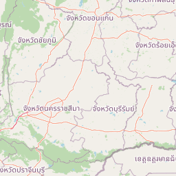
Map view of Pa Hin Ngam National Park

Use this park location map to pinpoint Pa Hin Ngam National Park in Thailand, understand its exact geographic position, and read its mapped placement within the surrounding landscape more clearly.

Pigeon | © OpenStreetMap contributors

Location context for Pa Hin Ngam National Park

Chaiyaphum Province
Park atlas

Compare other protected areas, tracing geographic connections and diverse natural landscapes adjacent to Pa Hin Ngam National Park's region.

Explore Nearby National Parks and Protected Areas Beyond Pa Hin Ngam National Park
Browse a selection of national parks and other protected natural areas that share regional geography and ecological features with Pa Hin Ngam National Park in northeastern Thailand. Compare these diverse conservation landscapes, gaining insight into connected mountain views, significant watersheds, and unique rock formations across a broader atlas context.
National parkChaiyaphum Province

Sai Thong National Park: Protected National Park in Chaiyaphum Province's Geography

Explore mapped landscape and protected area context.

Sai Thong National Park is a designated national park located in Chaiyaphum Province, Thailand, contributing to the region's extensive network of protected areas. Its protected landscape identity is shaped by the geography of northeastern Thailand, offering a unique focus for map-based discovery and understanding the distribution of natural areas. Explore the mapped terrain and regional context of this significant natural landmark.

Area
319 km²
Established
1992
IUCN
II
Visitors
51.2K annual
National parkThailand

Tat Ton National Park: Thailand's National Park Geography and Mapped Landscape

Explore its protected boundaries and natural terrain.

Delve into the specifics of Tat Ton National Park, a protected natural area in Thailand. This page provides a detailed exploration of its mapped boundaries, regional geography, and the character of its natural terrain. Understand its value as a national park for understanding the distribution of protected landscapes and how they contribute to the overall geographic context of Thailand.

Area
217 km²
Established
1980
IUCN
II
Visitors
388.7K annual
National parkPhetchabun Province

Tat Mok National Park: A National Park within Phetchabun Province's Mapped Landscapes

Exploring its protected land and regional geographic context.

Tat Mok National Park is a designated national park offering rich opportunities for geographic discovery. Situated in Thailand's Phetchabun Province, this protected area contributes to the region's atlas of natural landscapes. Users can explore the mapped boundaries and understand the park's place within the broader geography of Phetchabun, highlighting its role as a conservation landscape within Thailand.

Area
290 km²
Established
1998
IUCN
II
Visitors
17.9K annual
National parkSaraburi Province

Namtok Chet Sao Noi National Park: Protected Landscape and Seven-Tiered Waterfall Geography

Mapped terrain within Saraburi Province, Thailand.

Namtok Chet Sao Noi National Park offers a rich exploration of Thailand's natural geography, centered around its famous seven-tiered Chet Sao Noi waterfall. This national park, situated in Saraburi Province, features tropical rainforest ecosystems and distinctive landscapes within the Dong Phaya Yen mountains. Understand the park's mapped boundaries and its role as a vital protected area, providing insight into central Thailand's natural terrain and conservation efforts.

Area
42 km²
Established
2016
IUCN
II
Visitors
389.1K annual
National parkPhetchabun Province

Khao Kho National Park: Protected Landscape Geography and Mapped Boundaries

Discover natural terrain within Phetchabun Province.

Gain insight into Khao Kho National Park, a key protected area situated in Phetchabun Province, Thailand. This entry focuses on its geographic significance, mapped park boundaries, and its place within the diverse landscapes of lower northern Thailand. Explore the atlas-ready details that define Khao Kho National Park as a distinct protected landscape, offering a clear view of its regional context and natural terrain.

Area
483 km²
Established
2012
IUCN
II
Visitors
33.6K annual
National parkPhetchabun Province

Nam Nao National Park: Protected Landscape and Regional Geography

Explore maps and natural terrain of this Northern Thailand park.

Nam Nao National Park, situated in Phetchabun Province, Thailand, is a large national park distinguished by its rugged mountainous terrain and extensive pine forest landscapes. This protected area is vital for its role in conservation, housing significant biodiversity and forming a natural boundary between regions. Through its mapped geography and diverse natural settings, Nam Nao National Park offers a key destination for understanding protected land dynamics and regional natural landscapes.

Area
966 km²
Established
1972
IUCN
II
Visitors
31.8K annual
National parkThailand

Phu Pha Man National Park: Dramatic Cliffs, Caves, and Dinosaur Tracks in Thailand's Protected Landscape

Explore mapped geography and prehistoric fossil sites within Thailand's Phu Pha Man National Park.

Phu Pha Man National Park is a protected area in Thailand distinguished by its rugged limestone formations, significant cave networks, and dramatic waterfalls. Beyond its scenic beauty, the park is a globally important site for paleontology, holding Asia's oldest known dinosaur tracks. This page provides an atlas-style view of its protected landscape, local geography, and the unique prehistoric discoveries that define its identity.

Area
350 km²
Established
2000
IUCN
II
Visitors
9.7K annual
National parkLoei Province

Phu Kradueng National Park: Sandstone Mesa Protected Landscape and Geographic Atlas

Discover mapped boundaries and pine savanna terrain.

Phu Kradueng National Park, situated in Loei Province, Thailand, is a remarkable protected area defined by its large sandstone mesa and striking cliff-edged summit plateau. This page offers detailed geographic insights into the park's unique landscape, including its pine savanna ecosystems, diverse forest types transitioning from lower slopes to the summit, and its cool, refreshing climate. Explore Phu Kradueng National Park's mapped boundaries and natural terrain for a deeper understanding of this significant conservation landscape.

Area
348 km²
Established
1962
IUCN
II
Visitors
86.3K annual

Common questions about visiting, size, designation, and location context for Pa Hin Ngam National Park

Pa Hin Ngam National Park FAQs for park facts, access, geography, and protected area context
Find quick answers about Pa Hin Ngam National Park, including protected-area facts, park geography, trail and visitor context, and how the park fits into its surrounding country and regional landscape.
MoriAtlas Explorer

Continue Your Protected Areas Search Across the Global Atlas

Deepen your exploration by continuing the structured search for national parks and protected areas worldwide. Utilize the comprehensive filtering capabilities to compare different conservation landscapes and refine your understanding of global park geography. Discover more about the distribution and characteristics of protected natural areas.

Global natural geography