Mori Atlas logo
Protected landscapePark Krajobrazowy Chełmy

Mapping the volcanic hill country and ancient deciduous forest corridors of the Kaczawskie Foothills

Park Krajobrazowy Chełmy: A Geological and Ecological Protected Landscape in Lower Silesia

Park Krajobrazowy Chełmy serves as a significant protected landscape within the Lower Silesian Voivodeship, preserving an unusual geological record that spans Paleozoic, Permian, and Tertiary volcanic activity. This region captures a dense mosaic of basalt-capped summits, deep stream-cut gorges, and rare brekinia oakwood forests that support significant orchid populations. The area functions as a vital geographic segment of the Kaczawskie Foothills, demonstrating the complex tectonic and erosion patterns inherent to the border of the Sudetes.

landscape parkSudetes foothillsPogórze KaczawskieLower Silesiavolcanic geologybasalt hills

Park Krajobrazowy Chełmy

Protected landscape

Park overview

Structured park overview, official facts, and landscape profile for Chełmy Landscape Park

Chełmy Landscape Park park facts, protected area profile, and essential visitor context

Review the core facts for Chełmy Landscape Park, including designation, size, terrain, visitor scale, habitats, and operating context in one park-focused overview.

About Chełmy Landscape Park

Chełmy Landscape Park stretches across roughly 16,000 hectares in the Lower Silesian Voivodeship, occupying a transitional landscape where the Sudetes descend toward the Silesian Lowland. From the northeast, the terrain drops sharply along the Sudecki Uskok Brzeżny fault scarp, sliced by deep, breakthrough stream valleys; inland, the land rises into the most mountainous section of the Kaczawskie Foothills, locally known as the Chełmy.

What sets the park apart at a continental scale is the stacking of geological periods within a relatively small area. Beneath the surface lie early Paleozoic metamorphic rocks of the Kaczawskie Metamorphic complex (including greenstones, phyllites, sericite schists, quartz schists, graphitic schists, lydites, and mélanges), Permian sedimentary rocks of the Leszczyna Basin (sandstones, mudstones, conglomerates, limestones, dolomites, and marls), Triassic and Upper Cretaceous sandstones in places, and Permian volcanic rocks of the Rów Świerzawski (porphyries and their tuffs). Through all of these, Tertiary basalts of the Central European basalt province were intruded, producing today's rocky summits, basalt boulder fields, pillow lavas near Myślibórz, Jakuszowa, and Grobla, and striking columnar basalt formations at Czartowska Skała, Górzec, Bazaltowa Góra, Mszana, Rataj, and Radogost.

Ecologically, the park is a stronghold for deciduous forest communities in a region otherwise heavily altered by agriculture. Oakwoods, beech forests, mixed oak-hornbeam forests, and riparian alder stands make up the bulk of woodland; light oak-birch fringes, meadows, pastures, and small built-up areas fill the rest. The presence of source-protected flora is exceptionally high, with dozens of strictly protected plant species and a particular abundance of wild orchids.

Beyond science, the park holds a distinctive cultural signature. In the medieval period much of the area belonged to the Cistercian monastery of Lubiąż, and the park's old trade routes predate modern settlement patterns. The very name Chełmy derives from the Old Slavic word cholmy, used in the Middle Ages to describe the rolling hills that fill the park; this Slavic-rooted place-name is a quiet reminder that the region was reported and named long before any modern administrative border existed.

Quick facts and research context for Chełmy Landscape Park

Chełmy Landscape Park was established on 29 June 1992 by order of the Legnica Voivode and was the first landscape park created in the former Legnica Voivodeship. The park lies in the Lower Silesian Voivodeship, primarily in the Jawor and Złotoryja counties, with the protected area itself comprising around 16,000 hectares and the buffered protective zone adding roughly 12,500 hectares more.

The terrain sits within several distinct physical regions: the eastern Kaczawskie Foothills (also called the Złotoryjskie Foothills or Chełmy), the eastern Rów Świerzawski, the eastern ridge of the Kaczawskie Mountains, and the northwestern Chojnów Plain. Forests cover approximately 55 percent of the park and are chiefly deciduous; almost the entire area is included in the Natura 2000 site Góry i Pogórze Kaczawskie.

Protection and recognition

Examine the verified terrestrial protection scope and regional designation records

Park Krajobrazowy Chełmy Protection Status and Designated Area Facts

Park Krajobrazowy Chełmy maintains a documented terrestrial protection scope within the regional landscape network. Verified administrative records outline the official conservation status without international recognition designations.

Protection details

Protection scope
Terrestrial
Transboundary protection
No
Buffer area
124.71 km²
Park context

Deeper park guide and search-rich context for Chełmy Landscape Park

Chełmy Landscape Park history, landscape, wildlife, and travel context

Explore Chełmy Landscape Park through its history, landscape character, ecosystems, wildlife, conservation priorities, cultural context, and seasonal travel timing in a structured park guide built for atlas discovery and search intent.

Why Chełmy Landscape Park stands out

The park is best known for its layered geological history, especially the relict volcanic structures from the early Paleozoic, the Permian, and the Tertiary. Tertiary basalts crown the highest Chełmy hills, while older greenstones, phyllites, and Permian sandstones and porphyries form the deeper substrate, giving the area an unusually complete cross-section of mountain-building and volcanic episodes for Central Europe. It is equally recognized for its ecological character: light-rich brekinia oakwoods unique in Poland to these foothills, an extraordinary density of orchid species for a single protected area of this size, and a forest mosaic that supports rare birds, bats, amphibians, and a relict population of mouflon. The combination of geological, floristic, and faunal value is what makes the park stand out among Polish landscape parks.
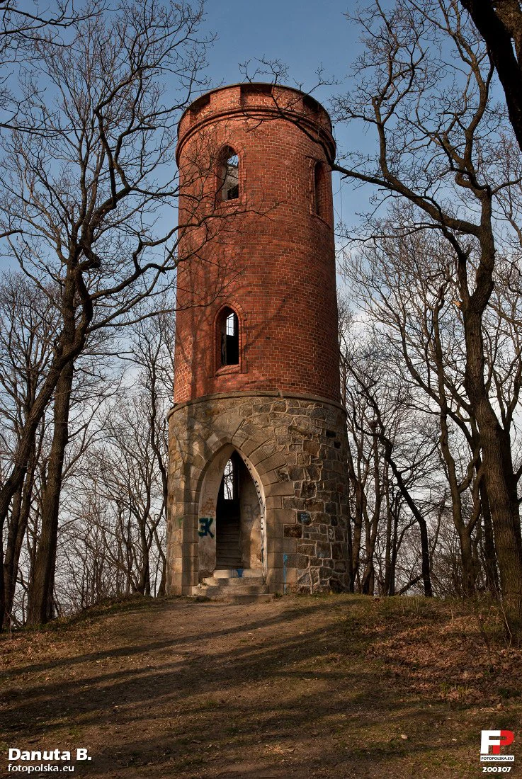
A cylindrical, two-story brick and stone observation tower set amidst leafless trees on a hill, featuring a Gothic-style arched entrance.
The historic Radogost observation tower, a notable landmark situated on Radogost hill within Park Krajobrazowy Chełmy.

Chełmy Landscape Park history and protected-area timeline

The protected area was formally created on 29 June 1992 under a regulation of the Legnica Voivode, making it the first landscape park established in the former Legnica Voivodeship. Its designation rested on extensive prior surveys that documented both the geological distinctiveness of the Kaczawskie Foothills and the unusually high botanical value of its forests.

Long before protection, however, the land carried multiple layers of human history. In the Middle Ages, much of the area lay under the economic influence of the Cistercian monastery at Lubiąż, and medieval trade routes crossed the hills that now form the core of the park. The Polish name Chełmy itself reaches back to Old Slavic and was already in use in the medieval period to describe the local hill country.

In 2015, the landscape park's youngest nature reserve, Mszana i Obłoga, was added, extending the strictly protected network within the park. Planning documents of the surrounding communes envisage further ecological sites and reserves, including proposed protection for Rataj Hill, the Muchów meadows, the Kondratów forest, and Swarna Góra, indicating that the park's conservation network is still evolving.

Chełmy Landscape Park landscape and geographic character

The landscape of Chełmy Landscape Park is dominated by a hill country shaped by both ancient tectonics and younger volcanic events. The northeastern edge of the park rises in a steep fault scarp, the Sudecki Uskok Brzeżny, and falls toward the flat Silesian Lowland. This break is deeply incised by streams that have carved breakthrough valleys through the resistant Paleozoic and Permian bedrock.

Inland, the topography becomes a sequence of forested ridges, basalt-capped summits, and narrow ravines. The Chełmy hills, the most mountainous portion of the Kaczawskie Foothills, owe their highest points to Tertiary basalt intrusions and their varied relief to differential erosion of the underlying metamorphic and sedimentary rocks. Notable landforms include the columnar basalt cliffs at Czartowska Skała and Radogost, the boulder-covered Muchowskie Wzgórza, the basalt hill at Bazaltowa Góra, and the strangely preserved pillow lavas near Myślibórz, Jakuszowa, and Grobla.

Streams and small rivers give further texture to the terrain. The entire park drains into the Kaczawa river system; the Wilcza, Jawornik, Młynówka, and the Nysa Mała cross the area, and their valleys are often framed by Pleistocene clays, sands, loess, and scattered glacial erratics, particularly near Nowa Wieś Wielka.

Chełmy Landscape Park ecosystems, habitats, and plant life

Forests cover roughly 55 percent of the park, and they are overwhelmingly deciduous: pedunculate and sessile oak stands, beech forests, mixed oak-hornbeam forests, and ash-alder riparian woodland. Smaller surfaces go to shrubs, meadows, pastures, arable fields, settlements, and roads, creating a richly varied mosaic.

A defining feature is the brekinia oakwood community, an association of oak and wild service tree (Sorbo torminalis, Quercetum) that in Poland is documented only on the Kaczawskie Foothills. Among flowering plants, orchid richness stands out: representative species include sword-leaved helleborine, white helleborine, common twayblade, fen orchid, bird's-nest orchid, and several Dactylorhiza marsh orchids. Other notable species include Martagon lily, common foxglove, twinflower, alternate-leaved golden saxifrage, spring snowflake, common snowdrop, and the locally rare Siberian iris on trembling-grass meadows near Nowa Wieś Wielka and Siedmica.

Habitats range from dry, light-rich oakwoods on basalt and limestone-influenced slopes to wet meadows, river corridors, and shaded ravine forests. This ecological diversity is what supports the area's unusually dense flora of protected plants: 75 species of protected vascular plants have been recorded, 64 of them under strict protection.

Chełmy Landscape Park wildlife and species highlights

The park supports an exceptionally rich animal community for its size. Birdlife is particularly strong, with around 133 recorded species, including black stork, corncrake, hoopoe, grey-headed woodpecker, Eurasian three-toed crossbill, collared flycatcher, red-breasted flycatcher, grey wagtail, Eurasian eagle-owl, Eurasian pygmy owl, European honey buzzard, and common kingfisher. Such a list reflects the park's mix of extensive deciduous canopy, open meadows, flowing streams, and edge habitats.

Mammals are represented by around 50 species, including wild boar, red deer, roe deer, Eurasian badger, and a relict population of mouflon. Bats are especially prominent, with 22 species recorded, indicating an abundance of caves, old trees, and riverine corridors. Amphibians number around 13 species, with fire-bellied toad, fire salamander, and smooth newt among the highlights. Six reptile species are present, including the smooth snake, alongside the stream lamprey, which lives in the park's brooks. Together, these groups paint the park as a genuinely biodiverse refuge on the edge of the Sudetes.

Chełmy Landscape Park conservation status and protection priorities

Almost the entire area of the park, apart from a northeastern and eastern fringe, lies within the Natura 2000 site PLH020037 Góry i Pogórze Kaczawskie, which covers roughly 35,000 hectares and represents the northern part of the broader Kaczawskie area. This integration into the European ecological network underlines the park's value at a continent-wide scale.

Within the park itself, protection is reinforced by five nature reserves: Wąwóz Myśliborski near Jawor, Wąwóz Lipa, Wąwóz Siedmicki, Nad Groblą, and the most recently designated, Mszana i Obłoga, created in 2015 as the youngest reserve in the voivodeship. Notable natural monuments include the Małe Organy Myśliborskie, a small columnar basalt formation, and the dramatic Czartowska Skała.

Beyond the existing reserves, local land-use plans anticipate additional ecological sites and new reserves around Rataj Hill, the Muchów meadows, the Kondratów forest, and Swarna Góra, suggesting that the conservation framework around the Chełmy hills is being progressively extended as new biological data emerge.

Chełmy Landscape Park cultural meaning and human context

The park's human story is closely tied to monastic landholding and medieval trade. In the Middle Ages, much of the area belonged economically to the Cistercian monastery at Lubiąż, whose influence structured land use, settlement patterns, and field systems in the foothills for centuries. Medieval trade routes crossed the hill country that now makes up the park, leaving traces that still align with today's villages and trails.

The very name Chełmy is itself a cultural artifact, derived from the Old Slavic word cholmy (meaning hills), which was already used in the medieval period as a name for the rolling uplands of the park. This Slavic-rooted toponym predates later German and Polish administrative layers and gives the region a continuous verbal identity stretching back more than a thousand years.

Today, the park contains and is surrounded by a network of small villages that anchor it in the rural life of Lower Silesia: settlements such as Grobla, Jakuszowa, Kłonice, Kondratów, Leszczyna, Muchów, Myślibórz, Myślinów, Nowa Wieś Mała, Nowa Wieś Wielka, Pomocne, Sokola, and Stanisławów lie inside or near the protected area, while Paszowice, Męcinka, and Złotoryja supply broader cultural context.

Top sights and standout views in Chełmy Landscape Park

The park's strongest highlights are its multi-period volcanic geology, the rare brekinia oakwood communities, and its exceptional orchid flora for a landscape park of this size. They are reinforced by a deep network of streams, ravines, and gorges, including the dramatic Wąwóz Myśliborski, Wąwóz Lipa, and Wąwóz Siedmicki, each protected as a nature reserve.

A second cluster of highlights lies in the area's cultural depth: medieval Cistercian landholding from Lubiąż, an old network of trade routes, and the Old Slavic place-name Chełmy itself, all of which place the park within a long historical continuum rather than a recently drawn boundary.

Best time to visit Chełmy Landscape Park

Spring is the most rewarding season for visitors interested in the park's botanical character: late April and May bring snowdrops, primroses, pheasant's eye, and the early orchid-rich meadows to life. Late spring and early summer reveal the richest displays of forest orchids and the meadow Siberian iris communities around Nowa Wieś Wielka and Siedmica, while summer offers the deepest forest immersion and full verdant visibility of basalt outcrops. Autumn brings dramatic color on the broadleaf slopes and quiet conditions for hiking the gorges and ridges, while winter, when access roads permit, showcases the basalt columns and ravines under snow.

Monthly climate preview

Long-term representative temperature and precipitation averages across the year

Park Krajobrazowy Chełmy Climate Normals and Weather by Month

Historical coordinate measurements for Park Krajobrazowy Chełmy establish a measured annual rhythm of shifting monthly temperatures and precipitation rates. Reviewing the complete twelve-month normals dataset provides deeper context for long-term regional atmospheric patterns.
Annual mean8 °C
-2 °C19 °C
Jan-2°
Feb-1°
Mar
Apr
May13°
Jun17°
Jul19°
Aug19°
Sep14°
Oct
Nov
Dec-1°
Warmest month
July

19.2 °C

Coolest month
January

-2.5 °C

Wettest month
July

3.1 mm/day

Driest month
April

1.3 mm/day

Park location guide

Geography guide, regional context, and park location map for Chełmy Landscape Park

Chełmy Landscape Park park geography, regions, and map view in Poland

Understand where Chełmy Landscape Park sits in Poland through a broader geographic reading of the surrounding landscape, nearby location context, and its mapped position within the national park landscape.

How Chełmy Landscape Park fits into Poland

Poland, officially the Republic of Poland, is a Central European country spanning from the Baltic Sea in the north to the Carpathian Mountains in the south. It borders Germany, Czech Republic, Slovakia, Ukraine, Belarus, Lithuania, and Kaliningrad Oblast. The country has a temperate climate, diverse landscapes, and is known for its rich history, cultural heritage, and strong economic position within the EU.

Wider geography shaping Chełmy Landscape Park in Poland

Poland occupies 312,696 km2 in Central Europe, extending from the Baltic Sea coast in the north to the Sudetes and Carpathian Mountains in the south. It borders Germany to the west, Czech Republic and Slovakia to the south, Ukraine and Belarus to the east, and Lithuania and Kaliningrad Oblast to the northeast. The landscape includes lowland plains, uplands, and mountain ranges.

Map view of Chełmy Landscape Park

Use this park location map to pinpoint Chełmy Landscape Park in Poland, understand its exact geographic position, and read its mapped placement within the surrounding landscape more clearly.

Pigeon | © OpenStreetMap contributors

Location context for Chełmy Landscape Park

Lower Silesian Voivodeship
Recorded earthquake history

Review Recorded Seismic History and Earthquake Data for Park Krajobrazowy Chełmy

Examine the historical catalogue of recorded seismic events associated with the surrounding terrain of Park Krajobrazowy Chełmy. MoriAtlas organizes these records by geographic proximity to support research into the seismic history of the Lower Silesian Voivodeship.

Park Krajobrazowy Chełmy Earthquake History

Catalogued events

986 events

Strongest magnitude

Magnitude 5

Most recent event

Jul 18, 2026

This history includes earthquakes recorded inside the park or within 50 km of its borders

Visualizing the terrain, forest habitats, and basalt hills of the Lower Silesian protected area.

Park Krajobrazowy Chełmy Photos: Exploring Landscapes and Volcanic Scenery

Examine detailed visual documentation of Park Krajobrazowy Chełmy to understand its unique volcanic geology and varied terrain. Reviewing these protected area photographs reveals the distinctive character of the forested ridges, gorges, and regional ecosystems.

A cylindrical, two-story brick and stone observation tower set amidst leafless trees on a hill, featuring a Gothic-style arched entrance.

A landscape view of open farmland and distant hills in Poland under a cloudy grey sky.

Park atlas

Compare surrounding foothill landscapes, volcanic terrain, and regional nature reserves

Other Parks Like Park Krajobrazowy Chełmy and Regional Protected Areas

Explore nearby protected areas and adjacent regional landscapes sharing the geological character of Park Krajobrazowy Chełmy. Comparing these surrounding natural reserves provides a deeper perspective on the diverse topography of the Sudetes foothills.
Nature reserveLower Silesian Voivodeship
Mapped location lies within the park boundary#1 closest

South

Rezerwat przyrody Mszana i Obłoga: Geological and Forest Protected Area Overview

Volcanic terrain in the Lower Silesian Voivodeship

This nature reserve preserves the natural maple-lime and oak-hornbeam forest communities found on the slopes of the Mszana and Obłoga hills. The area is defined by its striking basalt outcrops and volcanic rubble fields, providing a unique ecological character within the broader Kaczawskie foothills of southwestern Poland.

Area
0.999 km²
Established
2015
Relief
Mountain
Climate
Temperate
A soft watercolor painting of a river flowing through a hilly, forested landscape with light green and pastel tones.
Nature reserveLower Silesian Voivodeship
11 km away#2 closest

West

Ostoja nad Bobrem Nature Reserve and Bóbr River Valley Geographic Atlas

Protected Sudetes foothills landscape in Poland

Ostoja nad Bobrem represents a significant protected area within the Lower Silesian Voivodeship, characterized by its winding river corridor and hilly topography. The reserve supports a range of habitats including rare orchid-rich grasslands and dense slope forests. This atlas entry provides a detailed look at the geographic distribution and ecological importance of this essential Polish nature reserve.

Area
153.73 km²
Established
2009
Relief
Upland
Climate
Temperate
Protected areaLower Silesian Voivodeship
13 km away#3 closest

Southwest

Trzcińskie Mokradła Protected Area: Geographic Overview and Mapped Sudeten Wetland Landscape

Located in the Lower Silesian Voivodeship of Poland

Trzcińskie Mokradła stands as a significant mire complex in the Jelenia Góra Basin, providing a rare look at peat-forming habitats in the Sudetes. This protected area offers deep insight into regional wetland conservation and the environmental history of southwestern Poland, serving as an essential reference for researchers and landscape enthusiasts interested in intramontane basin geography.

Area
0.753 km²
Established
2011
Scope
Terrestrial
Water
Major water bodies
A minimalist, flat-design vector illustration showing a tall waterfall flowing down a rocky canyon flanked by pine trees and layers of cliffs.
Protected landscapeLower Silesian Voivodeship
22 km away#4 closest

South

Park Krajobrazowy Sudetów Wałbrzyskich: Protected Mountain Landscape Map

Geographic overview of forested ridges and rock formations

Gain insight into the topography of Park Krajobrazowy Sudetów Wałbrzyskich, where elevations reach 936 meters. This atlas entry details the forested Central Sudetes landscape, highlighting protected geological monuments like Małpia Skała and the unique hydrology of the Rybna river capture.

Area
64.93 km²
Established
1998
Relief
Mountain
Climate
Temperate
Watercolor illustration of a mountain range with green hills, pink and yellow sky, and sparse vegetation
National parkPoland
23 km away#5 closest

Southwest

Karkonosze National Park: A Premier National Park in Poland's Giant Mountains

Discover alpine terrain and unique glacial landscapes.

Karkonosze National Park is a significant protected area in Poland, renowned for its dramatic alpine topography carved by ancient glaciers. As the highest range in the Polish Sudetes, it features striking U-shaped valleys, U-shaped glacial cirques, and diverse subalpine to alpine ecosystems. This national park provides a rich context for understanding Central European mountain geography and exploring its mapped protected boundaries.

IUCN
II
Relief
Mountain
Scope
Terrestrial
Nature reserveLower Silesian Voivodeship
25 km away#6 closest

West

Żerkowice-Skała Nature Reserve: Mapped Sandstone Cuestas and Forest Habitats in Lower Silesia

A study of Cretaceous geology and protected forest landscapes in Poland

Żerkowice-Skała offers a window into the geological complexity of the Pogórze Izerskie. This nature reserve protects a vital sandstone cuesta edge, creating a mosaic of cliff habitats and old-growth deciduous forest communities. As a key Natura 2000 site, it serves as a crucial reference point for understanding the distribution of rare species and the northernmost Cretaceous exposures linked to the broader Bohemian Massif region.

Area
0.849 km²
Established
2011
Relief
Upland
Climate
Temperate
A minimalist watercolor illustration depicting rolling, layered mountain ridges in soft shades of green, yellow, and light pink against a white background.
National parkDolnośląskie Voivodeship
27 km away#7 closest

Southwest

Karkonoski Park Narodowy: Mapping Protected Granite Peaks and Glacial Terrain in Poland

High-mountain landscapes in the Dolnośląskie Voivodeship

Trace the diverse geography of Karkonoski Park Narodowy, where granite blockfields and glacial cirques define the high-altitude terrain. This protected area represents one of Central Europe's most significant upland ecosystems, showcasing a vertical transition from dense forest to alpine tundra.

Area
59.51 km²
Established
1959
Visitors
2M annual
Relief
Mountain
Watercolor painting showing green forests, a valley, and distant mountains under a soft sky
National parkLiberec Region
27 km away#8 closest

Southwest

Krkonoše National Park: Central European Alpine Protected Area and Map Context

Discover glacial landforms and unique ecosystems in the Giant Mountains.

Krkonoše National Park, situated in the Liberec Region, is a premier example of a protected alpine landscape in Central Europe. This page facilitates exploration of its significant glacial geography, including distinct cirques, rockfields, and valleys, providing vital context for understanding its protected area status. Engage with the mapped terrain and discover the unique ecological features that make this national park a cornerstone of conservation and geographic study within the Czech Republic.

Area
363.52 km²
Established
1963
IUCN
II
Visitors
12.1M annual

Common questions about visiting, size, designation, and location context for Chełmy Landscape Park

Chełmy Landscape Park FAQs for park facts, access, geography, and protected area context

Find quick answers about Chełmy Landscape Park, including protected-area facts, park geography, trail and visitor context, and how the park fits into its surrounding country and regional landscape.
MoriAtlas Explorer

Continue Your Protected Areas Search Across the Global Atlas

Deepen your exploration by continuing the structured search for national parks and protected areas worldwide. Utilize the comprehensive filtering capabilities to compare different conservation landscapes and refine your understanding of global park geography. Discover more about the distribution and characteristics of protected natural areas.

Global natural geography