
Mori Atlas logo
Regional parkPian del Re

Mapping the headwaters of the Po River and the dramatic terrain of the Monviso massif

Pian del Re Regional Park: Exploring the Glacial Geography and Protected Alpine Landscapes

Located in the heart of the Cottian Alps in Piemonte, Pian del Re serves as a crucial protected area defined by its high-altitude alpine plateau and glacial features. The park encompasses the vital springs of the Po River and diverse bog ecosystems that sustain rare alpine amphibians. Its rugged terrain and proximity to the Monviso massif offer essential geographic context for understanding the hydrology and mountain landscapes of northwestern Italy.

alpine plateauriver sourcePo River headwaterspeat bogalpine wetlandsrare amphibians
A flat-style vector illustration of a mountain valley scene, showing a waterfall cascading between cliffs into a river with evergreen trees in the foreground and a bright sun in the sky.

Pian del Re

Regional park

Park overview

Structured park overview, official facts, and landscape profile for Pian del Re

Pian del Re park facts, protected area profile, and essential visitor context

Review the core facts for Pian del Re, including designation, size, terrain, visitor scale, habitats, and operating context in one park-focused overview.

About Pian del Re

Pian del Re occupies a distinctive position in the geography of the Italian Alps. At approximately 2,020 meters above sea level, the plateau sits in the upper Valle Po, the deep glacial valley that descends from the Monviso massif toward the Piedmont plain. Materially, Pian del Re belongs to the Parco del Monviso, a protected natural area designed to safeguard the alpine environment, the headwaters of the Po, and the landscapes surrounding one of the most prominent peaks of the Cottian Alps.

The defining feature of Pian del Re is the spring of the Po River. The river emerges from the mountainside here as a small but persistent flow, fed by snowmelt, glacial drainage, and alpine groundwater. From these modest beginnings, the Po ultimately crosses northern Italy and reaches the Adriatic Sea. Pian del Re therefore functions both as a hydrological starting point and as a symbolic site, representing the mountain origin of Italy's principal river and the broader connection between the Alpine environment and the country's lowland geography.

The ecological character of the area is shaped by water. The combination of cold alpine springs and saturated soils has produced bog habitat, including peat-forming communities of considerable botanical interest. These wet meadows harbor rare amphibians, and Pian del Re is one of the documented locations of the Lanza's salamander (Salamandra lanzai), an alpine endemic adapted to cool, moist environments. The surrounding slopes, forested with conifers in their lower reaches and opening into alpine pasture and rock above, reinforce the area's ecological diversity.

For visitors and trekkers, Pian del Re is also a central hub in the Monviso region. From here, hiking routes connect to the Quintino Sella hut, Giacoletti hut, and Viso hut, providing access to climbing routes on Monviso itself as well as passages into France, such as the historic tunnel known as the Buco di Viso and the crossing over the Colle delle Traversette. The area thus combines ecological, geographical, and exploratory significance within a single alpine setting.

Quick facts and research context for Pian del Re

Pian del Re lies at about 2,020 meters above sea level in the upper Po Valley, within the Cottian Alps and the Monviso mountain group. It is part of the municipality of Crissolo, in the Province of Cuneo, Piedmont, Italy, and falls within the protected area of the Parco del Monviso, administered by the Ente di gestione delle aree protette del Monviso.

The site marks the springs of the Po River, the longest river in Italy, and is notable for the presence of peat-forming wetlands and rare alpine amphibian populations. It is also a recognized starting point for ascents of Monviso and for the Giro di Viso circuit, linking the Pian del Re to the historic Buco di Viso tunnel between Italy and France.

Protection and recognition

Explore the official territorial designation records and management scope for Pian del Re

Pian del Re Protection Status and Documented Conservation Scope

Pian del Re maintains a documented terrestrial protection scope without imported international recognition sources or transboundary status. Structured conservation records outline the baseline protected area designation and management framework associated with the terrain.

Protection details

Protection scope
Terrestrial
Transboundary protection
No
Park context

Deeper park guide and search-rich context for Pian del Re

Pian del Re history, landscape, wildlife, and travel context

Explore Pian del Re through its history, landscape character, ecosystems, wildlife, conservation priorities, cultural context, and seasonal travel timing in a structured park guide built for atlas discovery and search intent.

Why Pian del Re stands out

Pian del Re is best known as the place where the Po River rises, one of the most symbolically important geographic locations in Italy. The alpine springs here have strong cultural as well as hydrological significance, marking the very beginning of the river that crosses the entire peninsula. The area is also distinguished by the combination of high-altitude peat bogs, glacial meltwater channels, and a population of the rare Lanza's salamander, an alpine amphibian found in very few locations in the western Alps. Together with its position beneath the Monviso massif, this mix of hydrology, habitat, and biodiversity defines the locality's identity.
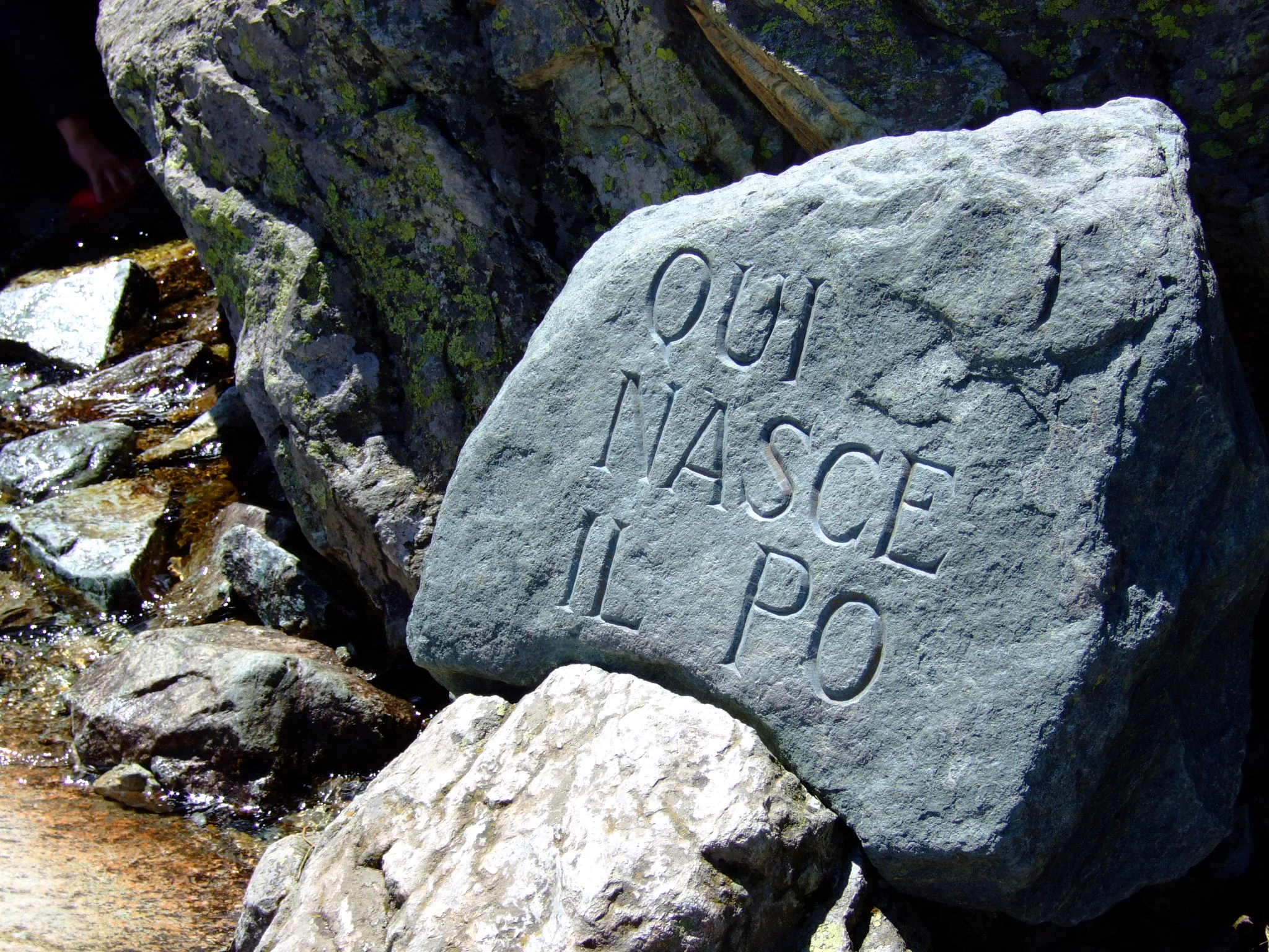
A close up view of a large grey boulder with the Italian text QUI NASCE IL PO carved into its surface, positioned next to a small mountain stream.
The stone marker at Pian del Re identifying the source of the Po River.

Pian del Re history and protected-area timeline

The name 'Pian del Re', literally the Plain of the King, derives from a notable historical episode. During the early sixteenth century, when Francis I of France campaigned against the Duchy of Savoy, his forces established encampments in this high-altitude plain. The toponym has persisted into the modern era as a reminder of the area's strategic and military history on the Alpine frontier between France and the House of Savoy.

In the modern period, Pian del Re has been recognized primarily for its environmental and geographical value. Its inclusion in the Parco del Monviso brought formal protection to the springs of the Po and to the surrounding alpine habitats. The locality has also gained public visibility through cycling: the Pian del Re served as the finishing point of two stages of the Giro d'Italia, in 1991 and 1992, both of which approached the site from lowland Piedmont and reinforced its place in the wider Italian geographic imagination.

Pian del Re landscape and geographic character

The landscape of Pian del Re is shaped by the steep glacial geography of the upper Valle Po. The plain itself is an open alpine expanse of flat or gently sloping terrain, set at over 2,000 meters, surrounded by the towering slopes of the Monviso group. The basin collects the meltwater from surrounding snowfields and glaciers, feeding the channels that become the headwaters of the Po.

Above and around the plateau, the terrain rises into rugged alpine rock, scree, and glacial cirques. Below the plain, the valley transitions through coniferous forest and meadow before reaching the lower slope village of Crissolo at about 1,333 meters. The visual character of the area is defined by the contrast between the wide, water-rich plain and the sharp relief of the Monviso massif that looms above it, creating one of the most identifiable alpine panoramas in the Cottian Alps.
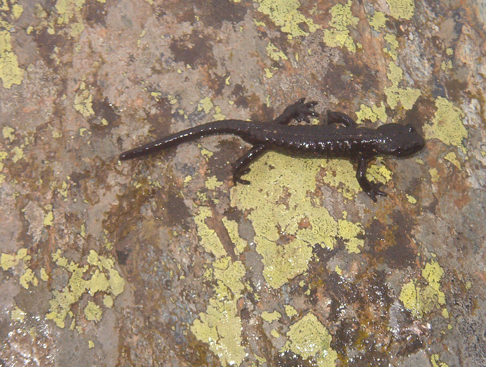
A small dark brown salamander with a shiny skin texture positioned on a rough, multicolored stone covered with yellow and grey lichen.
A Lanza's alpine salamander resting on a lichen covered rock at Pian del Re.

Pian del Re ecosystems, habitats, and plant life

The ecological identity of Pian del Re is dominated by water and cold-adapted habitats. Cold springs, snowmelt, and saturated soils have produced peat bogs and wet meadows of considerable importance within the broader alpine context. These wetlands support a specialized flora adapted to consistently moist conditions and provide breeding and shelter habitat for alpine amphibians.

The surrounding altitudinal gradient adds further ecological layers. Lower slopes carry montane and subalpine conifer forest, transitioning upward into alpine meadow, shrub communities, and ultimately bare rock and scree near the upper peaks of the Monviso group. The combination of wetland, forest, alpine meadow, and high-mountain rock within a relatively compact area gives the locality a notable concentration of alpine habitat types.

Pian del Re wildlife and species highlights

Pian del Re is particularly notable for its amphibian fauna. The site is one of the documented locations of Lanza's salamander (Salamandra lanzai), a rare alpine species endemic to a limited range in the western Alps. The presence of this salamander reflects the importance of cold, moist microhabitats associated with the spring and bog environment.

Beyond amphibians, the broader protected area of the Parco del Monviso supports a typical suite of alpine wildlife, including species associated with montane forests, alpine meadows, and higher rocky terrain. Although the source material focuses most specifically on the salamander, the area's habitat diversity suggests a wider community of mammals and birds typical of the Cottian Alps, and the park's protected status is intended to conserve these populations alongside the more emblematic hydrological features.

Pian del Re conservation status and protection priorities

Pian del Re lies within the Parco del Monviso, a protected natural area that safeguards the headwaters of the Po and the surrounding alpine landscape. The site's conservation value is intrinsically linked to water: the springs emerging here feed Italy's longest river, while the bog habitats and cold-water microclimatic conditions support species that depend on undisturbed alpine hydrology.

Protection of the area also extends to its rare amphibian populations, particularly the Lanza's salamander, which is regarded as a species of high ecological interest due to its restricted range. The combination of hydrological, botanical, and faunal values has motivated the conservation framework administered by the Ente di gestione delle aree protette del Monviso, ensuring that the springs, wetlands, and surrounding montane environments remain preserved within their broader Alpine context.

Pian del Re cultural meaning and human context

Pian del Re holds a dual cultural identity rooted in both history and geography. The toponym itself preserves the memory of the French royal encampments of the early sixteenth century, when this remote alpine plain became a stage in the wider European conflicts between France and the Duchy of Savoy. The persistence of the name reflects how deeply the event embedded itself in local memory and landscape.

At the same time, Pian del Re occupies an important symbolic place in Italian geographic culture as the recognized source of the Po River, a fact that has helped to establish the area within broader imagination of national landscape. The presence of Occitan terminology for nearby localities, such as Pian della Regina rendered as 'Escòlo dòu Pò' or 'Plan Melesé', further highlights the area's position within the Occitan-speaking Alpine heritage that characterizes the upper Valle Po.

Top sights and standout views in Pian del Re

The principal highlight of Pian del Re is the spring of the Po River, the symbolic and literal origin of Italy's longest waterway, emerging from the alpine groundwater at 2,020 meters above sea level. Equally important is the surrounding peat bog and wet meadow system, which supports rare alpine amphibians, including the localized Lanza's salamander, an endemic species of the western Alps.

The locality also stands out as a gateway to the Monviso massif. From Pian del Re, trekkers can access the Quintino Sella, Giacoletti, and Viso mountain huts, and reach the Colle delle Traversette and the historic Buco di Viso tunnel linking Italy and France. Together, these features combine a strong ecological profile with a distinctive role in the geography, history, and exploration of the Cottian Alps.

Best time to visit Pian del Re

The most accessible season for Pian del Re corresponds with the late spring through early autumn, typically from June to October, when the road from Crissolo through Pian della Regina is generally open. Snow cover and mountain weather conditions can extend winter conditions well into spring and bring early autumn snowfall, so the exact window varies year to year.

Outside this window, the locality becomes accessible mainly on foot, including via the historic Via del Sale trail from Crissolo, a route that rewards well-prepared hikers with the high alpine scenery and the spring environment of the Po. Visitors who come during the warmer months typically encounter the bog habitat and alpine meadows in their most biologically active state, with running water at the springs and clear approaches through the upper valley.


Monthly climate preview

Long-term temperature and monthly precipitation patterns sampled at elevation

Pian del Re Climate Normals and Measured Annual Temperature Rhythm

Pian del Re exhibits a measured annual temperature and precipitation rhythm derived from NASA Power climatology records spanning nineteen ninety-one to twenty twenty. Examining the complete twelve-month profile reveals detailed monthly averages that support comprehensive climate analysis across the protected landscape.
Annual mean5 °C
-5 °C15 °C
Jan-5°
Feb-4°
Mar
Apr
May
Jun13°
Jul15°
Aug15°
Sep11°
Oct
Nov
Dec-4°
Warmest month
July

15.4 °C

Coolest month
January

-5 °C

Wettest month
November

3 mm/day

Driest month
July

1.4 mm/day

Park location guide

Geography guide, regional context, and park location map for Pian del Re

Pian del Re park geography, regions, and map view in Italy

Understand where Pian del Re sits in Italy through a broader geographic reading of the surrounding landscape, nearby location context, and its mapped position within the national park landscape.

How Pian del Re fits into Italy

Italy is a unitary parliamentary republic in Southern and Western Europe, located on the Italian Peninsula with the Alps to the north. It borders France, Switzerland, Austria, Slovenia, Vatican City, and San Marino, and shares maritime boundaries with several Mediterranean countries. The country has approximately 59 million residents and uses the Euro as its currency.

Wider geography shaping Pian del Re in Italy

Italy occupies a boot-shaped peninsula in southern Europe, bordered by the Alps to the north. It shares land borders with France, Switzerland, Austria, Slovenia, Vatican City, and San Marino. The country includes the Mediterranean islands of Sicily and Sardinia, along with approximately 800 smaller islands.

Map view of Pian del Re

Use this park location map to pinpoint Pian del Re in Italy, understand its exact geographic position, and read its mapped placement within the surrounding landscape more clearly.

Pigeon | © OpenStreetMap contributors

Location context for Pian del Re

Piemonte

Visualizing the high altitude terrain, glacial springs, and protected habitats of the Cottian Alps

Pian del Re Photos and Alpine Landscape Scenery

Visual records illustrate the rugged mountain terrain, glacial springs, and protected wetland habitats that define the upper Po Valley basin. Examining field photography reveals the distinct environmental character of the protected alpine plateau and surrounding Monviso massif.

A close up view of a large grey boulder with the Italian text QUI NASCE IL PO carved into its surface, positioned next to a small mountain stream.

A wide view of the grassy Pian del Re plateau in a mountain valley, featuring stone buildings, a small stream, and a steep, rocky mountainside in the background.

A small dark brown salamander with a shiny skin texture positioned on a rough, multicolored stone covered with yellow and grey lichen.

Park atlas

Compare adjacent mountain terrain and protected regions across the Cottian Alps

Exploring Parks Near Pian del Re and Surrounding Alpine Protected Landscapes

Visitors exploring the alpine wetlands around Pian del Re can continue into other high-altitude protected areas across the surrounding mountain region. Expanding the geographic comparison reveals connected glacial terrain, river headwaters, and diverse alpine habitats throughout the wider ecosystem.
Watercolor illustration of a mountainous landscape featuring a river, rolling hills, and green vegetation
National parkFrance
About 35 km away#1 closest

South

Mercantour National Park: Mapped Alpine Protected Landscape and Regional Geography

Explore France's dramatic Alps, park boundaries, and unique ecotones.

Mercantour National Park stands as a premier protected area within the French Alps, distinguished by its remarkable geographic diversity and ecological significance. This national park encompasses mountainous terrain featuring dramatic peaks, deep glacial valleys, and a unique ecotone where Mediterranean and Alpine ecosystems converge. MoriAtlas facilitates a detailed atlas-style exploration of Mercantour National Park, highlighting its mapped protected boundaries, varied natural landscapes, and its pivotal role in regional geography and conservation efforts.

Area
679 km²
Established
1979
IUCN
II
Visitors
800K annual
Watercolor illustration showing mountains, a winding river, and pine trees in a landscape
National parkFrance
About 46 km away#2 closest

West

Écrins National Park: Alpine Glaciated Terrain and Protected Landscape Details

Mapped boundaries and regional geography of a major French National Park.

Delve into Écrins National Park, a defining national park within the French Alps. This page provides a comprehensive overview of its protected landscape, focusing on its dramatic glaciated terrain, significant peaks such as the Barre des Écrins, and its position within the regional geographic context. Explore the mapped extent and understand the unique alpine environment of this protected area.

Area
925 km²
Established
1973
IUCN
II
Visitors
800K annual
A watercolor painting on a white background showing a landscape with rolling green hills, a small lake, and distant mountain ridges in shades of pink, purple, and green.
Nature reserveProvence-Alpes-Côte d'Azur
About 48 km away#3 closest

Northwest

Réserve naturelle régionale des Partias: Alpine Geography and Protected Nature Reserve Data

High-altitude mountain terrain in the southern French Alps

Covering slopes west of Briançon, Réserve naturelle régionale des Partias protects a layered alpine environment ranging from forested basins to rocky crests. This atlas entry provides a detailed geographic overview of the protected area, focusing on its distinctive mountain lakes, diverse soil substrates, and essential role in conserving alpine ecosystems.

Area
8.018 km²
Established
2009
IUCN
IV
Relief
Mountain
Watercolor painting depicting mountains, a river, and trees under a light sky
National parkSavoie
About 66 km away#4 closest

North

Vanoise National Park: Explore France's Original National Park in the Savoie Alps

Mapped Alpine geography, glacial terrain, and protected landscape.

Vanoise National Park is France's pioneering national park, a protected landscape of immense alpine beauty situated in the Savoie department. Renowned for its dramatic glacial terrain, over 100 peaks above 3,000 meters, and the iconic Alpine ibex, this park offers a profound geographic context. Explore its mapped boundaries and discover the unique atlas-level insights into France's mountainous protected areas and their ecological significance.

Area
534 km²
Established
1963
IUCN
II
Relief
Mountain
A watercolor painting of a river valley with soft green trees, rolling hills, and distant mountains under a light sky.
Nature reserveProvence-Alpes-Côte d'Azur
About 68 km away#5 closest

West

Réserve naturelle nationale de la haute vallée de la Séveraisse: Protected Alpine Corridor

High-mountain riverine landscape and buffer zone in Hautes-Alpes

This nature reserve encompasses a 4-kilometer stretch of the upper Séveraisse valley, focusing on alluvial riverbed habitat and peripheral mountain terrain. Located in the French Alps, the reserve provides a protected transition zone characterized by its narrow, U-shaped valley floor and steep rocky inclines, offering a key geographic link to the wider Écrins ecosystem.

Area
1.55 km²
Established
1974
IUCN
IV
A watercolor illustration of a landscape with purple and pink layered mountain peaks in the background and soft green trees in the foreground, set against a plain white background.
Nature reserveAuvergne-Rhône-Alpes
About 68 km away#6 closest

Northwest

Réserve naturelle nationale de la haute vallée du Vénéon: Alpine Geography and Protected Boundaries

High-altitude mountain terrain in the French Alps

The Réserve naturelle nationale de la haute vallée du Vénéon occupies 61 hectares of striking alpine terrain near the hamlet of La Bérarde. Its landscape of steep slopes and glacial deposits functions as a key protected buffer zone, supporting diverse flora and fauna within the broader mountainous geography of the Auvergne-Rhône-Alpes region.

Area
0.61 km²
Established
1974
IUCN
IV
A watercolor illustration showing a landscape with red rock formations, green vegetation, and a winding blue river.
Nature reserveProvence-Alpes-Côte d'Azur
About 75 km away#7 closest

South

Réserve naturelle régionale des gorges de Daluis: Red Rock Canyon and Geological Atlas

Protected canyon landscape in Provence-Alpes-Côte d'Azur

Defined by its vivid red pelite cliffs, Réserve naturelle régionale des gorges de Daluis functions as a significant protected canyon system. The terrain preserves rare mineralogy and diverse microhabitats, ranging from river-carved walls to upland slopes that support unique regional biodiversity in the Alpes-Maritimes.

Area
10.82 km²
Established
2012
IUCN
IV
Relief
Mountain
Watercolor illustration depicting green valleys, forests, and distant mountain peaks
National parkItaly
About 78 km away#8 closest

North

Gran Paradiso National Park: Italy's National Park Protected Landscape Atlas

Mapped boundaries and regional geography for a key Italian protected area.

Gran Paradiso National Park is a distinct national park entity within Italy, offering rich potential for atlas-driven geographic discovery. This MoriAtlas profile focuses on its protected landscape identity, providing essential context for understanding its mapped boundaries and its role within the regional geography of Italy. Explore the structured geographic details that make Gran Paradiso National Park a valuable component of any mapped landscape analysis.

Area
703 km²
Established
1922
IUCN
II
Relief
Mountain

Common questions about visiting, size, designation, and location context for Pian del Re

Pian del Re FAQs for park facts, access, geography, and protected area context

Find quick answers about Pian del Re, including protected-area facts, park geography, trail and visitor context, and how the park fits into its surrounding country and regional landscape.
MoriAtlas Explorer

Continue Your Protected Areas Search Across the Global Atlas

Deepen your exploration by continuing the structured search for national parks and protected areas worldwide. Utilize the comprehensive filtering capabilities to compare different conservation landscapes and refine your understanding of global park geography. Discover more about the distribution and characteristics of protected natural areas.

Global natural geography