Why Pico Codazzi Natural Monument stands out
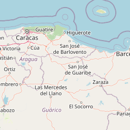
Pico Codazzi Natural Monument is best known for serving as the mountain connector between two of Venezuela's most important national parks in the Coastal Range. Rather than being valued primarily for a single iconic attraction, it stands out for its role as an ecological bridge between Henri Pittier and Macarao, both of which protect different elevational zones of the same mountain system. The monument is also notable for its karst geology. Its limestone massifs, cave systems, and vertical cliffs host rock formations of significant paleontological and environmental value. Above its geological character, the mountain ridges provide one of the most accessible vantage points in Venezuela for observing seasonal bird migrations, with North American and southern hemisphere species regularly crossing the corridor during the winter solstice period.
Pico Codazzi Natural Monument history and protected-area timeline
Pico Codazzi Natural Monument was formally established in 1991 as part of a Venezuelan effort to consolidate the protected area network of the central Cordillera de la Costa. Its creation responded to the recognition that Henri Pittier National Park and Macarao National Park, two flagship reserves of the Coastal Range, were geographically close but ecologically disconnected, with intervening lands vulnerable to encroachment, deforestation, and land-use change. By protecting the mountain terrain between them, the monument aimed to maintain habitat continuity across one of the most biodiverse stretches of Venezuelan mountain wilderness.
The mountain itself carries a longer human history. Its name commemorates Agustín Codazzi, the Italian-Venezuelan geographer and cartographer who is credited with the first recorded ascent of the peak in 1841, during his extensive geographic surveys of the country. The summit is also locally known as El Picacho, a name that reflects its prominence on the horizon above the surrounding valleys and that predates its formal protection.
In the decades after its designation, the monument has experienced increasing environmental pressure. Reduced habitat quality has diminished populations of typical Henri Pittier mammals and birds, while karst slopes remain susceptible to landslides triggered by weather-driven erosion. Despite these pressures, the protected status of the area has slowed further fragmentation of the mountain corridor and has provided an institutional framework for conservation planning in the central Coastal Range.
Pico Codazzi Natural Monument landscape and geographic character
The landscape of Pico Codazzi Natural Monument is dominated by steep, narrow ridgelines and deeply dissected valleys typical of the central Venezuelan Coastal Range. The terrain is built on limestone foundations that have been weathered over time into a series of distinct massif blocks. These massifs include prominent rocky summits such as Las Brisas and Peña de Mora, which rise sharply from the surrounding slopes and are renowned among local mountaineers for their dramatic profiles.
Throughout the monument, small watercourses descend from higher elevations, cutting gullies and cave systems into the calcareous bedrock. Seasonal runoff has produced surcadas, elongated cavities and tunnels that give parts of the area a distinctly karst character. Vertical cliffs and exposed rock faces are common, particularly along the upper slopes, while gentler terrain is generally restricted to narrow valley bottoms and ridgeline plateaus. The combination of vertical rock, sculpted caves, and shifting cloud cover gives the mountain a constantly changing visual character.
Slope stability is a defining concern of this landscape. Weathering and lixiviation, the chemical leaching of soluble minerals from rock, have reduced compaction across much of the calcareous terrain, making rockfalls and landslides a recurring feature of the area. The summit itself, Pico Codazzi or El Picacho, is one of the highest points of the entire state of Aragua, with documented elevation estimates ranging between roughly 1,818 and 2,429 meters, depending on the survey consulted.
Pico Codazzi Natural Monument ecosystems, habitats, and plant life
The natural character of Pico Codazzi Natural Monument is shaped by its position within the montane forest belt of the Venezuelan Coastal Range. Vegetation is dominated by semi-deciduous forests and semi-deciduous shrublands that thrive at mid to upper elevations where moisture from the Caribbean side of the range produces persistent humidity and frequent cloud immersion. This vegetation pattern reflects the transitional nature of the area: lower slopes give way to increasingly dense, moisture-loving montane plant communities as elevation increases.
Above the forest line, exposed rocky outcrops and cliff faces host more specialized plant communities adapted to thin soils and high solar exposure. The karst geology of the monument introduces an additional ecological layer, because calcium-rich substrates support plant and microbiological communities that differ from those on adjacent siliceous or volcanic formations. The combination of forest cover, shrubland, exposed cliff habitat, and rocky cave environments gives the protected area a mosaic of ecological niches despite its compact size.
Ecologically, the monument functions primarily as a connector rather than an isolated refuge. Its continuous forest cover provides shade, moisture, and feeding grounds for species that range across the larger Henri Pittier to Macarao corridor. By maintaining this corridor intact, the area ensures that ecological processes such as seed dispersal, pollination, and seasonal migration, can occur without abrupt breaks in suitable habitat.
Pico Codazzi Natural Monument wildlife and species highlights
Wildlife in Pico Codazzi Natural Monument reflects the area's role as a transitional mountain refuge between two of Venezuela's most biodiverse national parks. The monument sits on a major migratory flyway, and during the winter solstice period it receives an influx of migratory birds coming from both North America and the southern hemisphere. These species move along the Coastal Range ridgelines and disperse into the Henri Pittier forests to the south of the monument. From the higher slopes of Pico Codazzi, observers can often watch these migration corridors in action as flocks continue inland and toward the deeper reaches of the continent.
Resident birdlife is also significant. Daily and seasonal movements of birds that normally inhabit Henri Pittier extend into the slopes and valleys surrounding the monument, adding a dynamic layer of animal activity to the area. Beyond birds, the mountain historically supported populations of medium-sized mammals such as the lowland paca, porcupines, deer, and agoutis, as well as a range of rodents. Environmental pressures have reduced the abundance of these mammals, but the continued presence of forested cover means they remain part of the monument's fauna.
Reptiles and amphibians also occupy the area, including several species of snakes such as the fer-de-lance, or mapanare, and a broader community of lizards that once flourished across the lower slopes. Despite environmental impact, insect diversity remains notable, with butterflies of the genus Morpho and various nymphalid species among the most conspicuous, along with a wide variety of moths and spiders, including the woodlouse hunter spider. This invertebrate richness supports the broader food web on which birds and small mammals depend.
Pico Codazzi Natural Monument conservation status and protection priorities
From a conservation perspective, Pico Codazzi Natural Monument is valued less for its size than for its placement. By occupying the mountain corridor that separates Henri Pittier National Park from Macarao National Park, it prevents two of the most important reserves of the central Coastal Range from becoming ecologically isolated fragments. The combined area of Henri Pittier, the connecting corridor of Pico Codazzi, and Macarao creates one of the largest continuous protected mountain complexes in northern Venezuela.
The monument's karst formations are a second conservation priority. Its limestone massifs, caves, and rock formations have both paleontological and environmental significance, and they support ecological communities that are absent from non-calcareous areas. Protecting these formations requires managing risks associated with rock instability, weathering, and erosion, since landslides and rockfalls have shaped the long-term evolution of the area and continue to influence which habitats remain viable.
Conservation challenges are substantial. The proximity of the monument to expanding urban and agricultural areas, combined with a road network that crosses and borders the protected area, creates ongoing pressure on wildlife populations and vegetation cover. Declines in populations of Henri Pittier-typical birds and mammals, as referenced in ecological surveys of the region, illustrate the vulnerability of even strategically placed protected areas. Maintaining the ecological function of the corridor remains the central long-term objective of the monument.
Pico Codazzi Natural Monument cultural meaning and human context
The mountain that gives the monument its name holds an important place in Venezuelan geographic and scientific history. It is named after Agustín Codazzi, an Italian-born geographer who settled in Venezuela in the nineteenth century and carried out some of the country's earliest systematic cartographic and topographic surveys. His first recorded ascent of the peak in 1841 took place during this period of exploration, and the mountain became a reference point in subsequent geographic literature.
At the local level, the monument is closely associated with two cultural landmarks of Aragua. The town of Colonia Tovar, founded in the nineteenth century by German immigrants and known for its distinct Central European-influenced architecture and agricultural traditions, lies along the mountain corridor adjacent to the protected area. La Victoria, a historically important regional capital, sits at the eastern boundary of the monument along the same road network. Together, these communities place Pico Codazzi within a landscape shaped by centuries of human habitation, small-scale agriculture, and traditional mountain lifeways.
Top sights and standout views in Pico Codazzi Natural Monument
Pico Codazzi Natural Monument combines high-elevation mountain scenery with strategic ecological connectivity, making it a small but disproportionately valuable piece of Venezuela's protected area network. Among its strongest qualities are its role as a wildlife corridor, its karst geology, and its prominence within the Coastal Range skyline.
Few protected areas in Venezuela match its function as a direct habitat bridge between two major national parks. Few also combine such geological singularity, including limestone massifs and cave systems of paleontological interest, with a position on one of the country's most active bird migration routes.
Best time to visit Pico Codazzi Natural Monument
The mountain climate around Pico Codazzi produces two broadly distinct seasonal experiences. During the wetter months, the upper slopes of the Coastal Range are frequently covered in cloud and mist, emphasizing the cloud forest character of the vegetation and producing dramatic views of valleys shrouded in fog. Migratory bird activity peaks around the northern winter solstice, when North American and southern hemisphere species move through the mountain corridor and can be observed from the upper slopes.
In drier periods, the visibility improves substantially, allowing clearer views across the Coastal Range and toward the Caribbean coastal plain. Lower humidity also reduces the frequency of sudden weather changes that can affect high-elevation travel. For visitors primarily interested in birdwatching and migration observation, the late autumn and early winter months offer the most reliable viewing, while visitors focused on landscape photography and panoramic scenery often find the drier season more rewarding.