Peaks
Хлевен (Хамбарташ)
2,653.9 m

Detailed analysis of Blagoevgrad Province alpine zones, peak distributions, and habitats.
This geographic profile tracks the spatial characteristics of Pirin National Park within Bulgaria, focusing on its expansive 403.56 square kilometer mountain terrain. Users can examine recorded elevation data reaching up to 2914 meters and investigate the distribution of significant natural features such as Vihren, Dautov, and various alpine forest and wetland habitats.

Bulgaria's alpine wilderness of glacial lakes, endemic flora, and ancient forests
Pirin National Park occupies the greater part of the Pirin Mountains in southwestern Bulgaria, spanning 403.56 square kilometers of pristine alpine terrain. Established in 1962 and originally named Vihren National Park, the park was designated a UNESCO World Heritage Site in 1983 for its outstanding natural value. The landscape rises from 950 meters near Bansko to 2,914 meters at Vihren, Bulgaria's second-highest summit and the third-highest in the Balkan Peninsula. The park encompasses dramatic marble and granite ridges, deep cirques, and the southernmost glaciers in Europe, creating a remarkable mosaic of alpine ecosystems that support extraordinary biodiversity and endemism.
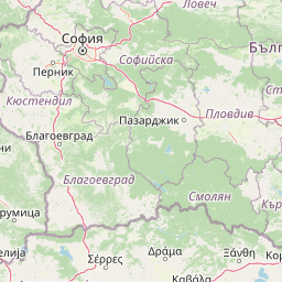
National and provincial placement within Bulgaria and Blagoevgrad
Pirin National Park’s stored boundary encompasses 403.56 km²
Mountain relief metrics and mapped natural feature data
Peaks
2,653.9 m
Peaks
2,728 m
Peaks
2,746 m
Peaks
2,597.3 m
Streams
Streams
Alpine climate zones, forest cover, and terrain relief classifications
Mountains · Valleys · Lakes · Rivers · Glacier · Cliffs · Forest · Woodland · Grassland · Wetland
Temperate coniferous forest · Montane forest · Alpine meadow · Grassland · Riverine habitat · Lacustrine habitat
Compare mapped geography, alpine landscapes, and protected areas across the Pirin Mountains and neighboring regions.
North

Explore mapped boundaries and protected landscape features.
Rila National Park, situated in Bulgaria's Rila mountain range, stands as the country's largest national park and a vital protected landscape. Its territory is characterized by dramatic glacial topography, including the iconic Seven Rila Lakes, and ascends to Musala Peak, the highest summit in the Balkan Peninsula. This atlas entry details the park's extensive mapped boundaries and unique ecosystems, emphasizing its importance for understanding regional geography and protected area networks.
Southwest

A significant reservoir within a mountain-framed basin
Lake Kerkini functions as a vital wetland habitat in the Central Macedonia region of Greece. Created as a reservoir along the Strymon River, it serves as a central waypoint for migratory species while providing a structured landscape of water, reed beds, and riverside forest. This atlas entry covers its geographic boundaries and its character as a working ecosystem shaped by both natural features and agricultural heritage.
East
Mapped boundaries, old-growth ecosystems, and Balkan geography.
Rodopi Mountain Range National Park is a critical protected forest area in Greece, safeguarding one of Europe's last primeval forests, the Frakto Virgin Forest. As the nation's largest woodland conservation site, it showcases remarkable biodiversity and complex mountain terrain, from low-lying forests to subalpine meadows. This page provides detailed mapping context and geographic specifics for understanding this unique protected landscape and its ecological significance within the Rhodope Mountains.

South
Protected wetland basins and river gorge terrain in northern Greece
Spanning 159 square kilometers, this national park protects essential Mediterranean wetland habitats. Examine the unique intersection of Lake Korónia, the expansive Lake Vólvi, and the Richios River gorge that shapes the ecological character of this prominent Macedonian protected area.
Northeast
Explore mapped alpine terrain and ancient forests in Lovech Province.
Central Balkan National Park is a significant protected area in Bulgaria, renowned for its stunning mountain geography and exceptionally well-preserved ancient beech forests. Located within Lovech Province, the park's landscape is defined by dramatic peaks, including Botev Peak, deep canyons, and alpine meadows, offering a rich context for geographical exploration and understanding its protected status. Its ecosystem health and ecological value are underscored by multiple nature reserves and its recognition as part of a UNESCO World Heritage Site.
Northwest

Discover its mountain lake ecosystem and mapped natural landscape.
Vlasina Ramsar Wetland is a critical protected area in Serbia, notable for its high-altitude mountain lake and river ecosystem within the Rhodopian Mountains. This page details its mapped geographic boundaries, unique terrain, and protected landscape identity, offering users a focused atlas exploration of a significant natural site. Delve into the specific geography and conservation context that define this internationally recognized wetland.
Southwest
Mapping the unique geography of this vital European bird migration corridor.
Axios Delta National Park is a significant protected wetland located in Central Macedonia, Greece, renowned for its role as a critical stopover and breeding ground for countless bird species along the East Atlantic Flyway. The park's landscape is shaped by the Axios, Haliacmon, Loudias, and Gallikos river deltas, creating a dynamic mosaic of lagoons, reedbeds, and coastal dunes. As a Ramsar site and Natura 2000 network area, it highlights the importance of understanding mapped protected landscapes and their regional geographic context for conservation efforts. Explore the distinct natural features and ecological significance of this unique delta.
Southeast
Coastal lagoons and river delta protected landscapes
Gain insight into the ecological and geographic structure of Parc national de Macédoine-Orientale-et-Thrace. This protected area encompasses a complex mosaic of river deltas, shifting saline lagoons, and remnant riparian forests that anchor the natural landscape of Eastern Macedonia and Thrace.
Deepen your understanding of Pirin National Park by exploring its specific geographic features and protected area boundaries. This national park offers a unique window into the regional geography of Blagoevgrad Province. Continue your atlas-driven discovery to grasp the full mapped landscape context and the significance of Pirin National Park within Bulgaria's network of protected lands.