

Mori Atlas logo
National parkRadal Siete Tazas National Park

Discover the mapped boundaries and cascading terrain of this unique national park in Chile's Maule Region.

Radal Siete Tazas National Park: Dramatic Seven Cups Waterfall Atlas and Pre-Andean Landscape

Radal Siete Tazas National Park represents a vital protected landscape within Chile's Maule Region, renowned for its spectacular natural formations. This national park is defined by the iconic Siete Tazas, a series of seven distinct rock pools and waterfalls carved by the Claro River through dramatic pre-Andean terrain. Beyond these celebrated cascades, the park features high waterfalls like El Velo de Novia, offering a rich geographic context for atlas exploration and mapped terrain understanding.

Chilean national parksWaterfall parksPre-Andean forestsSouthern beech forestsCentral ChileMaule Region

Radal Siete Tazas National Park

National park

Park overview

Structured park overview, official facts, and landscape profile for Radal Siete Tazas National Park

Radal Siete Tazas National Park park facts, protected area profile, and essential visitor context

Review the core facts for Radal Siete Tazas National Park, including designation, size, terrain, visitor scale, habitats, and operating context in one park-focused overview.

About Radal Siete Tazas National Park

Radal Siete Tazas National Park protects a spectacular section of the Claro River as it descends through a steep pre-Andean canyon in central Chile's Maule Region. The landscape transitions from lower-elevation forest zones through the dramatic waterfall cascade area to higher volcanic foothills near Descabezado Grande. The Seven Cups formation represents a unique geological feature where the river has carved a series of terraced pools and falls through rocky terrain, creating what locals have long considered one of the most beautiful natural attractions in the region. The park's elevation range from 650 to 2,600 meters creates diverse microclimates and ecological zones within its boundaries. Visitors can experience the progression from lush riparian forests along the river canyon to more exposed rocky terrain and higher-elevation vegetation as they explore the park's trails. The area has been a protected reserve for decades before achieving full national park status in 2008, reflecting its importance in Chile's conservation network.

Quick facts and research context for Radal Siete Tazas National Park

Radal Siete Tazas National Park is located in Curicó Province, Maule Region, Chile, in the pre-Andean zone near Descabezado Grande volcano. The park covers 41.4 square kilometers with elevations ranging from 650 to 2,600 meters. Its signature landscape features seven consecutive natural pools along Claro River known as the Seven Cups, complemented by high waterfalls El Velo de Novia (40m) and La Leona (20m). The area protects southern beech forests dominated by various Nothofagus species and is home to the endangered burrowing parrot subspecies known locally as Tricahue.

Protection and recognition

Tracing the formal conservation framework and terrestrial management boundaries.

Radal Siete Tazas National Park Protection Status and Terrestrial Designation

Established in 2008, Radal Siete Tazas National Park operates under a terrestrial protection mandate to safeguard its regional ecology. Scholars and conservationists can explore the official designation timeline, geographic boundary classifications, and documented management scope.

Protection details

Protection scope
Terrestrial
Designated year
2008
Transboundary protection
No
Park context

Deeper park guide and search-rich context for Radal Siete Tazas National Park

Radal Siete Tazas National Park history, landscape, wildlife, and travel context

Explore Radal Siete Tazas National Park through its history, landscape character, ecosystems, wildlife, conservation priorities, cultural context, and seasonal travel timing in a structured park guide built for atlas discovery and search intent.

Why Radal Siete Tazas National Park stands out

Radal Siete Tazas is best known for its dramatic cascade system of seven waterfalls and rock pools along the Claro River. The Siete Tazas formation is the park's central attraction, drawing visitors who explore the sequence of natural pools connected by cascading falls. The area has become a popular destination for kayakers who navigate the smaller falls while tourists watch from platforms surrounding the steep canyon. The high waterfalls of El Velo de Novia (Bridal Veil) and La Leona (Lioness) add to the park's reputation as a premier waterfall destination in Chile's central regions.

Radal Siete Tazas National Park history and protected-area timeline

The Radal Siete Tazas area was originally protected as a reserve before being officially reclassified as a national park in 2008, bringing it into Chile's highest category of protected areas under the national park system. The park gained international attention in February 2010 when one of the Seven Cups' main attractions completely dried up following the massive magnitude 8.8 earthquake that struck central Chile. Geologists believed the earthquake opened a rock fissure that allowed the water to drain into an underground aquifer, fundamentally altering the famous waterfall display for a period. This natural event highlighted the geological complexity of the area and the delicate relationship between surface water systems and underground aquifers in the volcanic terrain. The park continues to be managed by Chile's National Forestry Corporation (CONAF), which maintains trails and visitor facilities throughout the protected area.

Radal Siete Tazas National Park landscape and geographic character

The physical landscape of Radal Siete Tazas National Park is defined by its steep pre-Andean topography and the dramatic river canyon that contains the famous waterfall system. The Claro River has carved a deep gorge through volcanic rock, creating the sequence of pools and falls that constitute the Seven Cups. The surrounding terrain features rocky cliffs, forested slopes, and the volcanic backdrop of Descabezado Grande in the distance. Elevations range from 650 meters along the river valley floor to 2,600 meters at the park's higher boundaries, creating dramatic changes in terrain character across relatively short distances. The canyon walls rise steeply around the waterfall area, providing dramatic viewpoints from which visitors can observe both the cascades below and the kayakers navigating the rapids. The combination of forested slopes, exposed rock faces, and the flowing water system creates a landscape of considerable scenic diversity within a relatively compact area.

Radal Siete Tazas National Park ecosystems, habitats, and plant life

The ecological character of Radal Siete Tazas centers on its southern beech forests dominated by trees of the genus Nothofagus, which dominate the park's lower and mid-elevation zones. The park protects several threatened Nothofagus species including Nothofagus glauca and the hybrid Nothofagus × leoni, alongside more common species such as Nothofagus macrocarpa, Nothofagus dombeyi, Nothofagus antarctica, and Nothofagus alpina. Beyond the southern beeches, the forest includes the vulnerable conifer Austrocedrus chilensis and the rare Maytenus chubutensis, both species of conservation concern in Chile. The riparian zones along the Claro River support distinctive plant communities adapted to the water-rich canyon environment. The diversity of elevation and aspect within the park creates multiple habitat types that support the overall biodiversity of the area.

Radal Siete Tazas National Park wildlife and species highlights

The park is notable for sheltering an endangered subspecies of the burrowing parrot, known locally as Tricahue (Cyanoliseus patagonus). This colorful parrot is a flagship species for the region's conservation efforts and represents one of the more distinctive bird species found within the protected area. The forest environment supports various bird species typical of central Chile's Andean foothills, while the river system and surrounding riparian habitat provide resources for additional wildlife. The steep canyon walls and rock faces offer nesting opportunities for cliff-dwelling species, while the forest canopy supports arboreal wildlife. While detailed species inventories are limited in the available source material, the presence of the endangered Tricahue parrot establishes the park's significance for avian conservation in the region.

Radal Siete Tazas National Park conservation status and protection priorities

Radal Siete Tazas National Park represents an important contribution to Chile's protected area network, designated as an IUCN Category II protected area reflecting its purpose of preserving natural ecosystems while allowing sustainable public use. The protection of the Nothofagus forest communities is particularly significant given that several of the beech species found within the park, including Nothofagus glauca and Nothofagus × leoni, are considered threatened. The presence of vulnerable tree species such as Austrocedrus chilensis and Maytenus chubutensis further elevates the conservation importance of the area. The park also protects watersheds important for downstream communities and maintains the ecological integrity of the Claro River system. The designation as a national park in 2008 formalized protections that had been in place through earlier reserve status, ensuring continued management of this scenic and ecologically significant area.

Radal Siete Tazas National Park cultural meaning and human context

The name Siete Tazas (Seven Cups) reflects the traditional Chilean Spanish naming of the seven pool-and-waterfall sequence along the Claro River, a name that has been used by local communities for generations. The area has long been a destination for regional visitors seeking to experience the natural beauty of the waterfall formations. The local name for the burrowing parrot, Tricahue, comes from Mapuche language influence, reflecting the indigenous heritage of the Maule Region. The park lies within territory historically associated with the Mapuche people, whose relationship with the pre-Andean landscapes of central Chile predates European colonization. The area's popularity for kayaking represents a more recent cultural use of the river, transforming the waterfall rapids into a recreational destination that brings visitors from across Chile and internationally.

Top sights and standout views in Radal Siete Tazas National Park

The Seven Cups waterfall and pool system remains the park's premier attraction, a sequence of seven terraced natural pools connected by cascading falls that create a staircase of water descending through the canyon. The high waterfall El Velo de Novia (Bridal Veil) offers a dramatic 40-meter vertical drop that ranks among the most impressive single-drop falls in Chile's central regions. Kayakers regularly navigate the smaller falls ranging from one to ten and a half meters, adding an adventure-sport dimension to the park's appeal. The pre-Andean setting near Descabezado Grande volcano provides a volcanic mountain backdrop that enhances the scenic character of the landscape. The southern beech forests represent a classic central Chilean forest type that visitors can explore along maintained trails through the protected area.

Best time to visit Radal Siete Tazas National Park

The park can be visited year-round, though the central Chilean climate means that spring and summer months (October through March) typically offer the most pleasant conditions for outdoor exploration. During these warmer months, the waterfall flows are generally stable and the forest vegetation is at its fullest, creating optimal conditions for viewing the Seven Cups and other cascades. Winter months (June through August) can bring cooler temperatures and occasionally reduced water flows, though the park remains accessible. The pre-Andean location means that higher elevations within the park may experience different conditions than the valley floor, so visitors planning to explore the full elevation range should be prepared for temperature variations. The 2010 earthquake demonstrated that natural geological events can temporarily alter the waterfall displays, though such occurrences are rare.
Monthly climate preview

Long-term representative measurements of monthly temperature and precipitation rhythms

Radal Siete Tazas National Park Climate Normals and Annual Temperature Patterns

Radal Siete Tazas National Park exhibits a measured annual cycle of shifting monthly temperatures and precipitation rates based on historical data. Detailed examination of the full twelve-month climatology profile reveals specific long-term averages across the representative coordinate.
Annual mean14 °C
7 °C22 °C
Jan22°
Feb21°
Mar19°
Apr15°
May11°
Jun
Jul
Aug
Sep10°
Oct13°
Nov16°
Dec19°
Warmest month
January

21.5 °C

Coolest month
July

7.3 °C

Wettest month
June

3.8 mm/day

Driest month
January

0.3 mm/day

Park location guide

Geography guide, regional context, and park location map for Radal Siete Tazas National Park

Radal Siete Tazas National Park park geography, regions, and map view in Chile

Understand where Radal Siete Tazas National Park sits in Chile through a broader geographic reading of the surrounding landscape, nearby location context, and its mapped position within the national park landscape.

How Radal Siete Tazas National Park fits into Chile

Chile is a presidential republic in western South America, extending as a narrow strip along the western edge of the continent between the Andes Mountains and the Pacific Ocean. It is the southernmost country in the world and the closest to Antarctica. The country is bordered by Peru, Bolivia, and Argentina, and administers several Pacific islands including Easter Island. Chile is a major copper producer and has a population of approximately 19.6 million.

Wider geography shaping Radal Siete Tazas National Park in Chile

Chile occupies a narrow strip of land along the western edge of South America, extending approximately 4,300 km north to south but only about 350 km east to west at its widest point. The country is sandwiched between the Andes Mountains to the east and the Pacific Ocean to the west. It shares borders with Peru to the north, Bolivia to the northeast, and Argentina to the east. Southern Chile borders the Drake Passage. Chile also administers several Pacific islands including Juan Fernández Islands, Isla Salas y Gómez, Desventuradas Islands, and Easter Island, plus the Chilean Antarctic Territory.

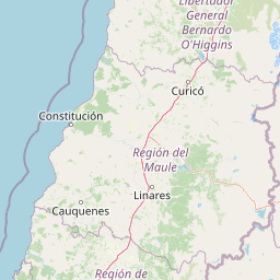
Map view of Radal Siete Tazas National Park

Use this park location map to pinpoint Radal Siete Tazas National Park in Chile, understand its exact geographic position, and read its mapped placement within the surrounding landscape more clearly.

Pigeon | © OpenStreetMap contributors

Location context for Radal Siete Tazas National Park

Curicó ProvinceMaule Region
Recorded earthquake history

View Historical Earthquake Records for Radal Siete Tazas National Park

Examine the historical catalogue of seismic events recorded in the vicinity of Radal Siete Tazas National Park. This data collection by MoriAtlas maps local earthquake occurrences, offering insight into regional seismic history through structured event records and distance-based analysis for this central Chilean landscape.

Radal Siete Tazas National Park Earthquake History

Catalogued events

623 events

Strongest magnitude

Magnitude 6.5

Most recent event

Jun 20, 2026

This history includes earthquakes recorded inside the park or within 50 km of its borders

Park atlas

Expand your atlas view to adjacent protected areas, exploring the varied pre-Andean geography and distinct conservation zones.

Continue Your Discovery: National Parks and Protected Areas Near Radal Siete Tazas National Park

Browse other national parks and protected areas in Chile's Maule Region, expanding your understanding of the diverse pre-Andean foothills and riverine landscapes. Comparing these protected areas offers valuable geographic context and highlights the regional spread of conservation efforts.
National parkLibertador General Bernardo O'Higgins Region
129 km away#1 closest

North

Las Palmas de Cocalán National Park: Chile's National Park Protected Landscape Atlas

Explore geographic boundaries and regional context.

Delve into the protected landscape identity of Las Palmas de Cocalán National Park, situated within the Libertador General Bernardo O'Higgins Region. This page provides detailed atlas-style information, focusing on the park's geographic features and its role as a national park. Understand the mapped natural terrain and the regional importance of this conserved area for comprehensive geographic discovery.

Area
3.709 km²
Established
1971
IUCN
II
Relief
Mixed relief
National parkSantiago Metropolitan Region
180 km away#2 closest

North

Río Clarillo National Park: National Park Boundaries and Geographic Atlas Context

Mapped protected landscape in Santiago Metropolitan Region.

Discover the distinct protected landscape of Río Clarillo National Park, a national park situated within Chile's Santiago Metropolitan Region. This entry is designed for atlas-style exploration, focusing on the park's mapped boundaries, its integration into the regional geography, and its significance as a protected natural area. Understand the geographic context and landscape characteristics that define Río Clarillo National Park, enabling a deeper appreciation of its role within the broader conservation map.

Area
101.85 km²
Established
1982
IUCN
IV
Relief
Upland
National parkBío Bío Region
210 km away#3 closest

South

Laguna del Laja National Park: Mapped Protected Area in Chile's Bío Bío Region

Explore regional park geography and landscape context.

Laguna del Laja National Park represents a key protected area with distinct geographic attributes within the Bío Bío Region. This profile focuses on its identity as a national park, providing context for its mapped boundaries and natural landscape. Discover its place in regional geography, offering valuable insights for any atlas-focused exploration of Chile's protected lands.

Area
119 km²
Established
1958
IUCN
II
Visitors
48.8K annual
Watercolor painting of a coastal landscape featuring palm trees, mountains, and a body of water
National parkValparaíso Region
266 km away#4 closest

North

La Campana National Park: Protected Landscape of Chilean Wine Palms

Explore its mapped terrain and regional geographic context.

La Campana National Park represents a significant protected landscape within Chile, celebrated for its exceptional concentration of Chilean Wine Palms (Jubaea chilensis). As a national park situated in the Valparaíso Region, it showcases a diverse range of Mediterranean ecosystems and dramatic coastal mountain terrain. This page provides detailed atlas-style context, highlighting the park's unique botanical heritage, its distinct geographic setting, and its importance as a mapped natural area for regional landscape studies.

Area
80 km²
Established
1967
IUCN
II
Visitors
39.6K annual
National parkLa Araucanía Region
306 km away#5 closest

Southwest

Nahuelbuta National Park: Ancient Araucaria Forests and Protected Highland Geography

Discover its mapped boundaries atop the Cordillera de Nahuelbuta.

Nahuelbuta National Park is a significant national park in Chile's La Araucanía Region, celebrated for its ancient monkey puzzle tree forests atop the Cordillera de Nahuelbuta. This protected area showcases a unique highland landscape with rugged terrain and exposed rocky outcrops, preserving species more typical of Andean and Patagonian environments. Understanding its mapped geography and protected landscape identity is key to appreciating its ecological importance and distinct position within South America's natural atlas.

Area
68 km²
Established
1939
IUCN
II
Relief
Mountain
National parkChile
307 km away#6 closest

South

Tolhuaca National Park National Park: Mapped Boundaries and Chilean Geography

Explore the protected landscape and regional context of this park.

Tolhuaca National Park is a protected national park located in Chile, offering a distinct point for geographic and landscape discovery. This detailed view focuses on the park's mapped boundaries, its environmental setting within Chile, and its overall protected-area identity. Engage with structured data that clarifies its position in the broader atlas of natural landscapes, providing context for regional geography and conservation efforts.

Area
64.74 km²
Established
1935
IUCN
II
Visitors
6.5K annual
National parkLa Araucanía Region
338 km away#7 closest

South

Conguillío National Park: Mapped Protected Landscape and Geographic Context

Discover unique terrain within La Araucanía Region's geography.

Conguillío National Park is a vital protected landscape offering rich opportunities for geographic discovery. This page details the park's specific location within La Araucanía Region, highlighting its mapped natural features and protected boundaries. Understand Conguillío National Park's role as a national park and explore its distinct terrain and regional landscape context.

Area
608 km²
Established
1950
IUCN
II
Visitors
21.8K annual
National parkNeuquén Province
391 km away#8 closest

South

Laguna Blanca National Park: National Park in Neuquén Province, Patagonia

Mapped protected area and regional landscape context.

Laguna Blanca National Park represents a key protected landscape within the expansive geography of Neuquén Province, located in the Patagonia region of Argentina. This national park entity serves as a critical node for atlas exploration, allowing users to understand its specific protected boundaries and its contribution to the regional protected-area network. Investigate Laguna Blanca National Park to gain insight into its unique geographic setting and its role within the mapped natural areas of Western Argentina.

Area
112.5 km²
Established
1940
IUCN
II
Relief
Upland

Common questions about visiting, size, designation, and location context for Radal Siete Tazas National Park

Radal Siete Tazas National Park FAQs for park facts, access, geography, and protected area context

Find quick answers about Radal Siete Tazas National Park, including protected-area facts, park geography, trail and visitor context, and how the park fits into its surrounding country and regional landscape.
MoriAtlas Explorer

Continue Your Protected Areas Search Across the Global Atlas

Deepen your exploration by continuing the structured search for national parks and protected areas worldwide. Utilize the comprehensive filtering capabilities to compare different conservation landscapes and refine your understanding of global park geography. Discover more about the distribution and characteristics of protected natural areas.

Global natural geography
