
Mori Atlas logo
Nature reserveRéserve naturelle régionale du marais de Condette

Mapping the hydrological landscape and mosaic of peat, woodland, and fen habitats near the Opal Coast.

Réserve naturelle régionale du marais de Condette: A Vital Wetland Sanctuary and Ecological Corridor in Hauts-de-France

The Réserve naturelle régionale du marais de Condette encompasses roughly 35 hectares of rare, intact wetland in northern France, serving as a critical ecological corridor between the Forêt d'Écault and the Forêt d'Hardelot. Centered around the Lac des miroirs, this protected area features a complex mosaic of peaty soil, wet meadows, and ancient woodlands that support diverse plant and bird species. The reserve functions as a natural flood expansion zone and maintains essential biodiversity within the fragmented landscape of the Hauts-de-France region.

wetland reserveregional nature reservemarshpeatlandlac des miroirsforested corridor
A flat-style digital illustration of a nature reserve featuring a winding dirt path, a small wooden bridge crossing a marshy stream, a tranquil lake, and lush vegetation under a soft sky.

Réserve naturelle régionale du marais de Condette

Nature reserve

Park overview

Structured park overview, official facts, and landscape profile for Réserve naturelle régionale du marais de Condette

Réserve naturelle régionale du marais de Condette park facts, protected area profile, and essential visitor context

Review the core facts for Réserve naturelle régionale du marais de Condette, including designation, size, terrain, visitor scale, habitats, and operating context in one park-focused overview.

About Réserve naturelle régionale du marais de Condette

The Réserve naturelle régionale du marais de Condette is a compact but ecologically rich protected area on the Opal Coast of northern France. It lies a few kilometers inland from the English Channel, in the commune of Condette, between two of the largest remaining coastal forests in the Boulonnais: the Forêt d'Écault to the north and the Forêt d'Hardelot to the south. The reserve sits at the heart of the Parc naturel régional des caps et marais d'Opale, a protected regional landscape that covers a large portion of the coastal Pas-de-Calais.

The defining feature of the reserve is the Lac des miroirs (Lake of Mirrors), a shallow water body surrounded by a complex mosaic of wet habitats. Around the lake, the marshland includes peat-forming zones, muddy and silty flats, hygrophilous meadows, tall herb communities known as mégaphorbiaies, and patches of more or less dense, sometimes old-growth woodland. Together these create a layered environment where aquatic, semi-aquatic, and terrestrial species coexist in close proximity. The interaction between open water, wet meadows, and forest explains much of the site's biological richness.

Geographically, the reserve occupies a strategic position. By linking two forested massifs and providing stepping-stone habitats toward the coastal dunes d'Écault, it functions as an essential node in the national and regional trame verte et bleue, the ecological connectivity network that aims to counteract landscape fragmentation. The area is also classified within the atlantic biogeographic zone, and the local climate is distinctly influenced by proximity to the sea, with mild winters and relatively cool summers typical of the Channel coast.

Although only about 35 hectares in size, the Marais de Condette is one of the most species-rich small reserves in northern France. Botanical surveys have documented several hundred plant species, while the bird list includes more than eighty breeding and migratory species. The site also hosts amphibians that have become rare or regressive in northern France, as well as bats, butterflies, dragonflies, and a diverse fungal community. Its combination of naturalness, biodiversity, and accessibility has made it both an ecological stronghold and a public nature destination.

Quick facts and research context for Réserve naturelle régionale du marais de Condette

Located in the commune of Condette (Pas-de-Calais), the Marais de Condette covers around 35 hectares of wetland, open habitats, and woodland within the Parc naturel régional des caps et marais d'Opale. Created on 25 May 2009, it is classified as a regional nature reserve (réserve naturelle régionale), the French equivalent of a category IV IUCN protected area focused on habitat and species management. The reserve is administered by Eden 62, a public consortium dedicated to managing sensitive natural spaces in the Pas-de-Calais.

Protection and recognition

Documented terrestrial protection scope, management framework, and international recognition data

Réserve Naturelle Régionale du Marais de Condette Protection Status and Official Designation Records

Terrestrial protection status records for Réserve naturelle régionale du marais de Condette outline the documented conservation scope and management framework. Official designation metrics and database references provide verified context for the protected area without speculative claims.

Protection details

Protection scope
Terrestrial
Transboundary protection
No
WDPA ID
555514388
Park context

Deeper park guide and search-rich context for Réserve naturelle régionale du marais de Condette

Réserve naturelle régionale du marais de Condette history, landscape, wildlife, and travel context

Explore Réserve naturelle régionale du marais de Condette through its history, landscape character, ecosystems, wildlife, conservation priorities, cultural context, and seasonal travel timing in a structured park guide built for atlas discovery and search intent.

Why Réserve naturelle régionale du marais de Condette stands out

The Marais de Condette is best known for being one of the most biodiverse relict wetlands left in the Boulonnais, a region otherwise heavily shaped by agriculture, urbanization, and forest fragmentation. Its mosaic of ponds, peat areas, wet meadows, tall-herb fens, and ancient woodland around the Lac des miroirs harbors an unusually high concentration of plant, amphibian, and bird species for such a small area. It is also recognized for its role as a green and blue infrastructure link, forming a critical ecological corridor between the Forêt d'Écault, the dunes d'Écault, and the Forêt d'Hardelot. The peat layers of the marsh further contribute to carbon storage and to climate resilience through their ancient seed bank.
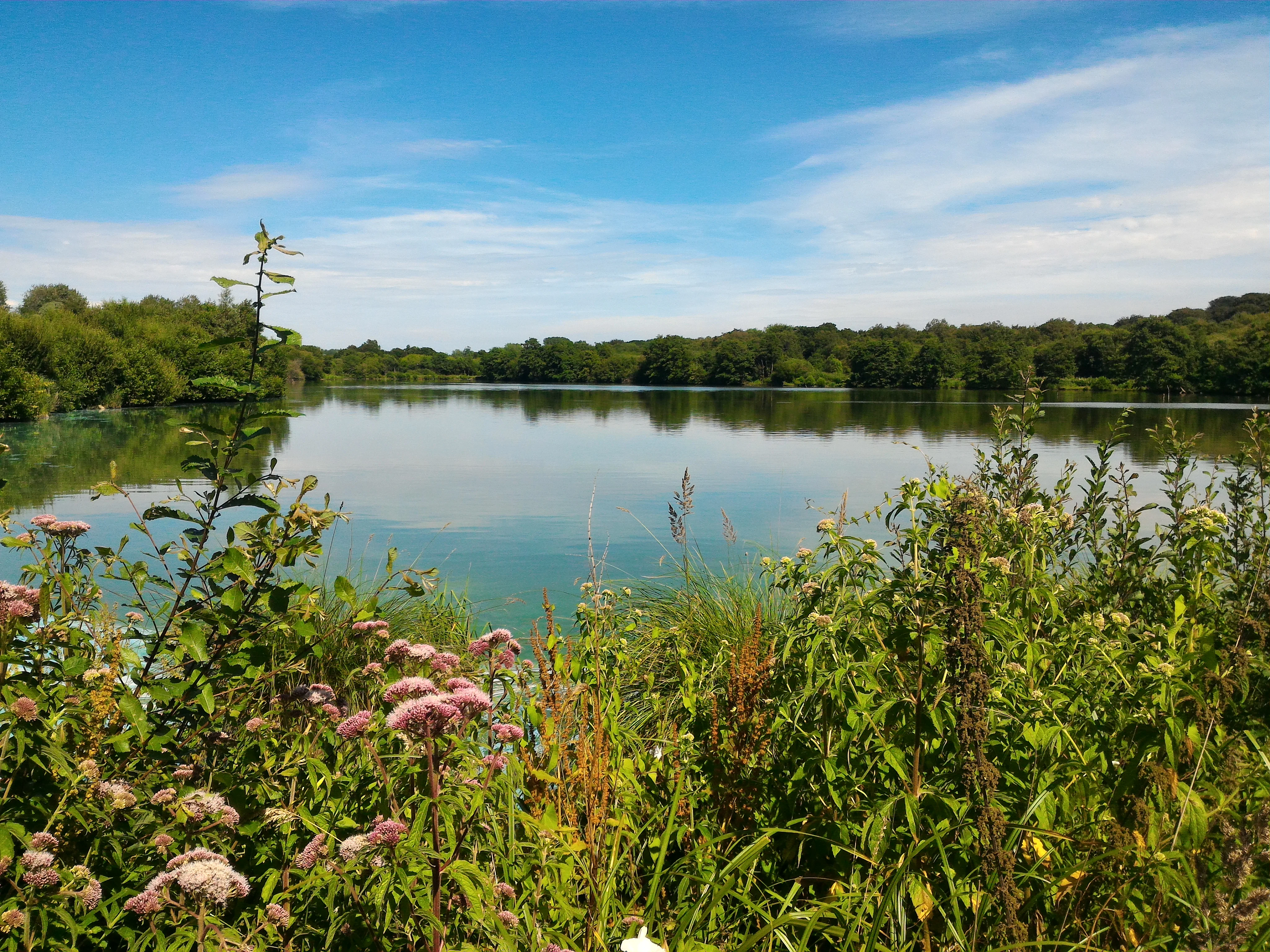
A calm lake surrounded by lush green trees and wild flowers under a bright blue sky with light clouds.
A peaceful view of Lac des Miroirs within the Réserve naturelle régionale du marais de Condette.

Réserve naturelle régionale du marais de Condette history and protected-area timeline

The history of the Marais de Condette stretches back well beyond its formal protection. As early as 1894, the departmental archivist reported to the prefect that the marsh and pasture lands of Condette were of such importance for the commune that a thick bundle of related records should be preserved in the departmental archives, an indication that the site was already recognized as locally significant. Through the 20th century, however, parts of the area were altered by human use, and by the early 2000s the site had long served partly as a leisure base.

Between 2005 and 2008, a restoration project costing around 1.5 million euros transformed the site, aiming to return it to a more natural state resembling its early 19th-century condition. The work included the creation of oak boardwalk pathways, the installation of interpretation panels on the site's history, geomorphology, flora, and fauna, and the introduction of accessible routes designed for wheelchairs and visually impaired visitors in anticipation of a Tourism and Disability label.

The reserve's formal status came on 25 May 2009, when it was officially designated a réserve naturelle régionale under French regional nature reserve legislation. In February 2012, the French Ministry of Sustainable Development recognized the site with the national prize for biodiversity in an urbanized environment, an award that highlighted the reserve's role in maintaining ecological quality in a coastal region otherwise shaped by tourism and urbanization. Since its designation, the site has been managed by Eden 62, a public consortium that oversees several sensitive natural areas across the Pas-de-Calais.

Réserve naturelle régionale du marais de Condette landscape and geographic character

The landscape of the Marais de Condette is fundamentally a wetland landscape shaped by water, peat, and a long fringe of trees. The center of the reserve is occupied by the Lac des miroirs, a calm, mirror-like body of water whose reflective surface gives the reserve much of its visual character. Around it spread a patchwork of marshy and flooded zones, including peaty areas where organic matter accumulates in waterlogged conditions, silty and muddy flats, and seasonal pools that fill and drain with the hydrological cycle.

Bordering the open water and marsh are wet meadows and tall-herb fens, where dense vegetation of reeds, sedges and large-leaved herbs creates a transitional belt between aquatic and terrestrial habitats. The outer ring of the reserve is composed of more or less dense woodlands, including older stands that add vertical structure and shade to the landscape mosaic. Although the reserve itself is small and flat, it is framed by two larger forested massifs, the Forêt d'Écault to the north and the Forêt d'Hardelot to the south, while to the west lies the Château d'Hardelot area with its open meadows and historical estate landscape.

Seen from a wider perspective, the reserve forms a green depression in an otherwise urbanized coastal strip, and its flat, low-lying topography contrasts with the dunes and cliffs elsewhere along the Opal Coast. This combination of still water, herbaceous marsh, and woodland distinguishes the Marais de Condette from the more exposed coastal habitats nearby and gives it a quiet, intimate atmosphere unusual for such a densely inhabited region.
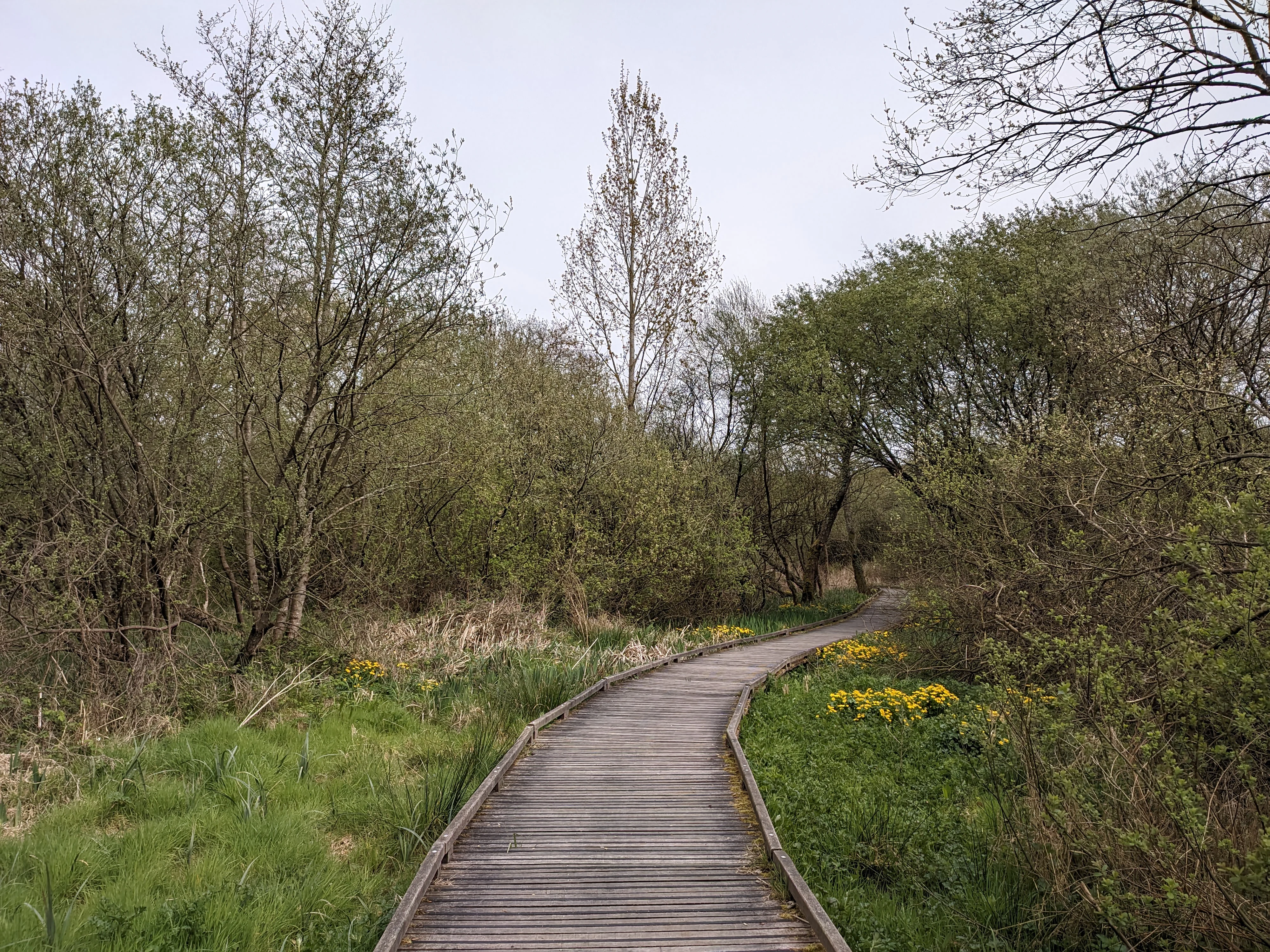
A wooden boardwalk trail snakes through a dense thicket of trees and shrubs with green spring foliage and yellow flowering plants along the path edges.
A wooden boardwalk winding through the marshy landscape of the Réserve naturelle régionale du marais de Condette.

Réserve naturelle régionale du marais de Condette ecosystems, habitats, and plant life

Ecologically, the Marais de Condette is a textbook example of a relict wetland complex in an atlantic biogeographic setting. Its value lies primarily in the diversity and naturalness of its habitats rather than in any single dominant ecosystem. The site combines three main habitat types: wetlands dominated by the Lac des miroirs and surrounding marsh; open habitats such as wet meadows and tall-herb fens; and woodlands of varying density and age.

This mosaic is unusual in the Boulonnais, where remaining natural areas are often small and isolated. By bringing together aquatic, semi-aquatic, and forest habitats in close proximity, the Marais de Condette supports a high density of species per unit area. Botanical diversity is particularly striking: more than 340 vascular plant species have been recorded, including several patrimonial taxa of high conservation interest such as the great spearwort (Ranunculus lingua), butcher's broom (Ruscus aculeatus), marsh cinquefoil (Comarum palustre), and royal fern (Osmunda regalis).

The peat layers beneath the marsh add a further ecological dimension. They hold an ancient seed bank that can contribute to ecological resilience under climate change, and they function as a natural carbon sink. Because the surrounding region is heavily fragmented by agriculture, roads, and coastal urbanization, the reserve also plays an important role in regional ecological connectivity, acting as a hub in the trame verte et bleue that links forests, dunes, and inland habitats along the Opal Coast.
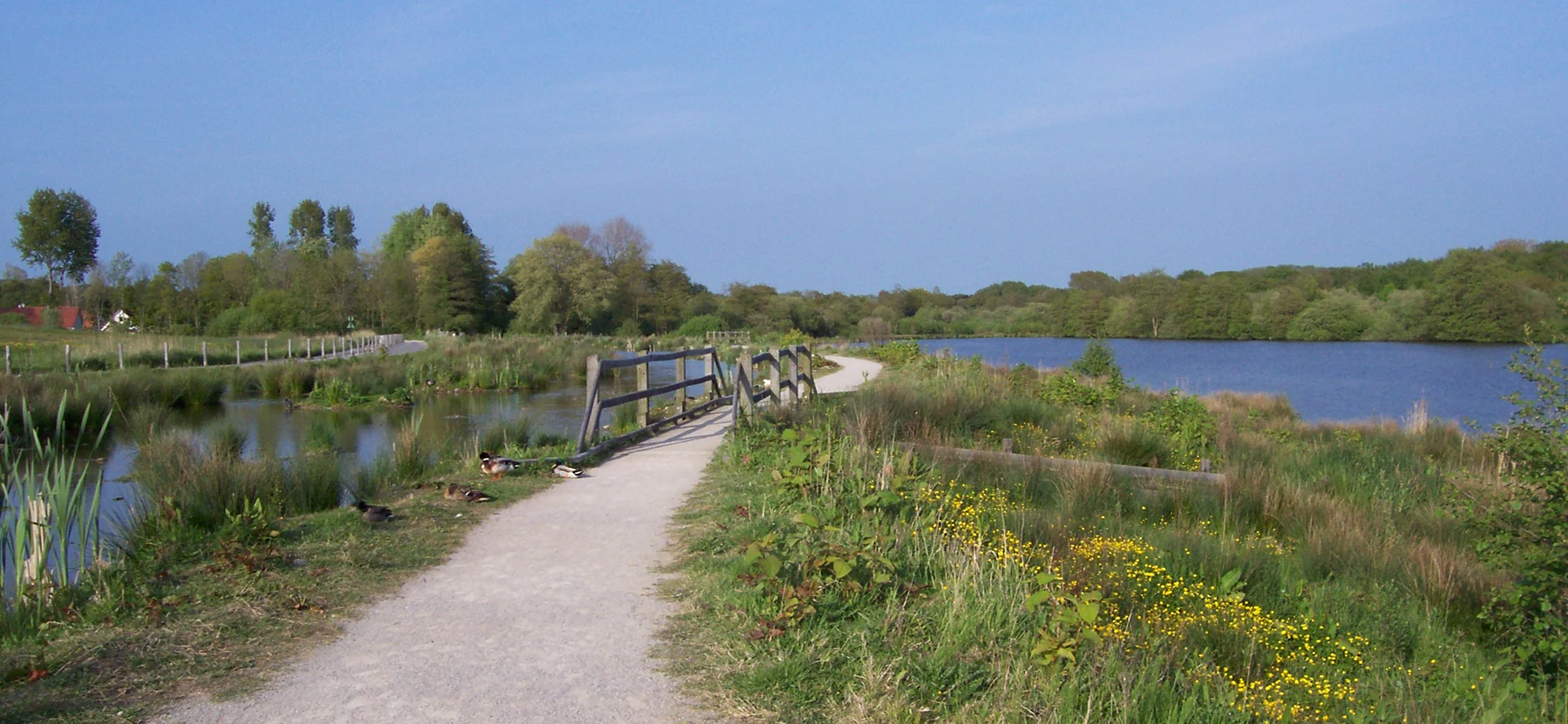
A gravel trail crosses a small wooden bridge over a marshy area near a large pond, with trees and greenery in the background under a clear sky.
A gravel path leads over a wooden footbridge, winding through the marshland and wetlands of the Réserve naturelle régionale du marais de Condette.

Réserve naturelle régionale du marais de Condette wildlife and species highlights

The wildlife of the Marais de Condette reflects the diversity of its habitats, with an unusually rich fauna for a site of its size. More than 80 bird species have been recorded, either breeding in the marsh or using it as a stopover during migration. The mixed waterbird and forest bird communities include species such as common sandpiper, green sandpiper, black-headed gull, common tern, grey heron, water rail, sedge warbler, Eurasian reed warbler, reed bunting, common redpoll, red crossbill, Eurasian sparrowhawk, European honey buzzard, and Eurasian hobby. The presence of waterbirds together with forest raptors emphasizes the reserve's role as a meeting point between very different habitat types.

Amphibians are among the most ecologically significant groups at the site. At least seven species live in and around the marsh, and several are of conservation concern in northern France. These include the common toad, common frog, European tree frog, fire salamander, alpine newt, smooth newt, and palmate newt, many of which have experienced significant declines at similar latitudes in Europe. The site's combination of standing water, shaded woodland, and humid terrestrial habitats is particularly favorable for amphibian reproduction and overwintering.

Mammals are also present and include at least twelve recorded species, ranging from the widespread red squirrel to rarer woodland and wetland-associated bats such as the greater mouse-eared bat (Myotis myotis). In addition, the marsh supports a notable invertebrate fauna, including a variety of butterflies and dragonflies, while the fungal community of the woodlands adds further biodiversity. Concerns about long-term wildlife health focus on diffuse threats such as nutrient enrichment of the surrounding environment and the delayed impact of agricultural pesticides carried into the basin by runoff and rainfall.

Réserve naturelle régionale du marais de Condette conservation status and protection priorities

From a conservation perspective, the Marais de Condette is a model of how a small protected area can play an outsized role in a heavily modified region. Its designation as a regional nature reserve in 2009 was specifically justified by the exceptional richness and naturalness of its aquatic and flood-prone habitats, especially the mosaic of peaty, muddy, and forested environments that supports a wide range of species in a landscape otherwise fragmented by human activity.

The reserve is an important node in both the national and the regional trame verte et bleue, the ecological connectivity frameworks designed to link natural habitats across France. By sitting between the Forêt d'Écault, the dunes d'Écault, and the Forêt d'Hardelot, it provides both refuge habitat and dispersal stepping-stones for species that would otherwise struggle to move across the densely populated and cultivated coastal plain. The site also has functional value for water management: as a flood expansion zone, it helps buffer downstream areas against flooding and mitigates the effects of drought and heatwaves in a region increasingly exposed to climate extremes.

Restoration and management actions are central to the reserve's conservation strategy. Between 2005 and 2008, large-scale earthworks and habitat restoration aimed to recreate conditions closer to the site's early 19th-century state, while ongoing management focuses on the herbaceous layer and on maintaining the balance of open, semi-open, and wooded habitats. Threats monitored by the site managers include general eutrophication of the surrounding environment and the delayed effects of pesticides transported through the watershed. Recognition at the national level came in February 2012, when the French Ministry of Sustainable Development awarded the site its biodiversity prize in an urbanized environment, underlining both its ecological value and its role as a high-quality natural space within a heavily populated coastal region.

Réserve naturelle régionale du marais de Condette cultural meaning and human context

The Marais de Condette is embedded in a region with a long cultural relationship with coastal and wetland landscapes. The commune of Condette has historically been oriented around its pastures and wetlands, as evidenced by the late 19th-century archival records that already treated the marsh and grazing lands as an important component of local identity. The neighboring Château d'Hardelot, just west of the reserve, anchors the area in a broader heritage landscape of forests, estates, and historic coastal routes.

The reserve is also part of the territorial identity of the Opal Coast (Côte d'Opale), a coastal stretch known as much for its natural areas, dunes, and forests as for its seaside resorts such as Hardelot-Plage. By offering accessible paths, interpretive panels, and educational programs, the Marais de Condette has become a tool for environmental education and for reconnecting residents and visitors with a landscape that has otherwise been heavily developed. In this sense, the reserve represents a contemporary layer of regional identity built on the long-standing relationship between local communities and the wetland environment.

Top sights and standout views in Réserve naturelle régionale du marais de Condette

A small reserve with an exceptional concentration of aquatic, marsh, and woodland habitats forming a key ecological corridor between the forests of Écault and Hardelot; roughly 35 hectares of mosaic wetland recognized by the French Ministry of Sustainable Development as a model of biodiversity in an urbanized coastal setting; a Lac des miroirs surrounded by peat areas, wet meadows, and old woodland; more than 340 plant species and at least 80 bird species, including rare amphibians for northern France; accessible boardwalks and interpretive trails designed both for recreation and for environmental education along the Opal Coast.

Best time to visit Réserve naturelle régionale du marais de Condette

The Marais de Condette can be visited year-round thanks to its open public paths and accessible infrastructure, and each season offers a different character. Spring is particularly rewarding, when water levels are restored, vegetation bursts into growth, and breeding birds and amphibians are most active in and around the Lac des miroirs.

Summer brings lush, dense vegetation and a wider range of dragonflies and butterflies, as well as the fullest display of wetland flora, while still offering quiet shaded walks on the oak boardwalks. Autumn is favorable for observing migratory birds and for appreciating the changing colors of the surrounding woodlands. Winter, with milder temperatures moderated by the nearby sea, can be a good season for spotting waterbirds and for enjoying the atmospheric calm of the marsh at its most reflective; visitors should be prepared for wet, sometimes muddy conditions along the paths at any time of year.
Monthly climate preview

Long-term representative monthly temperature and precipitation patterns across the protected landscape

Climate Normals and Annual Temperature Rhythm for Réserve naturelle régionale du marais de Condette

Representative coordinates track twelve-month temperature averages and precipitation rates across the protected terrain from historical climatology data. Examining the complete monthly climate profile reveals specific shifts in thermal ranges and moisture patterns throughout the year.
Annual mean10 °C
4 °C17 °C
Jan
Feb
Mar
Apr
May12°
Jun15°
Jul17°
Aug17°
Sep15°
Oct11°
Nov
Dec
Warmest month
August

17.1 °C

Coolest month
January

3.6 °C

Wettest month
December

3 mm/day

Driest month
April

1.7 mm/day

Park location guide

Geography guide, regional context, and park location map for Réserve naturelle régionale du marais de Condette

Réserve naturelle régionale du marais de Condette park geography, regions, and map view in France

Understand where Réserve naturelle régionale du marais de Condette sits in France through a broader geographic reading of the surrounding landscape, nearby location context, and its mapped position within the national park landscape.

How Réserve naturelle régionale du marais de Condette fits into France

France is a unitary semi-presidential republic and one of the world's largest economies. It borders Belgium, Luxembourg, Germany, Switzerland, Italy, Monaco, Andorra, and Spain, with a maritime border to the United Kingdom. The country is known for its cultural influence, art, cuisine, and political history spanning centuries.

Wider geography shaping Réserve naturelle régionale du marais de Condette in France

France is located in Western Europe. Metropolitan France extends from the Rhine to the Atlantic Ocean and from the Mediterranean Sea to the English Channel and North Sea. The country borders Belgium, Luxembourg, Germany, Switzerland, Italy, Monaco, Andorra, Spain, and has a maritime border with the United Kingdom.

Map view of Réserve naturelle régionale du marais de Condette

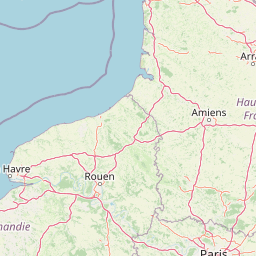
Use this park location map to pinpoint Réserve naturelle régionale du marais de Condette in France, understand its exact geographic position, and read its mapped placement within the surrounding landscape more clearly.

Pigeon | © OpenStreetMap contributors

Location context for Réserve naturelle régionale du marais de Condette

Hauts-de-France
Recorded earthquake history

Review Recorded Seismic History for Réserve naturelle régionale du marais de Condette

Navigate to a structured catalogue of historical earthquakes associated with this protected wetland area. MoriAtlas provides filtered event data based on epicentre distance, allowing for a clear understanding of recorded seismic activity within the vicinity of the reserve.

Marais de Condette Earthquake History

Catalogued events

7 events

Strongest magnitude

Magnitude 4

Most recent event

Jan 27, 1998

This history includes earthquakes recorded inside the park or within 50 km of its borders

Visual exploration of wetland habitats, the Lac des miroirs, and protected terrain

Réserve naturelle régionale du marais de Condette Photos, Landscapes, and Scenery

Visual records capture the mosaic of wetlands, open water, and ancient woodlands that define Réserve naturelle régionale du marais de Condette. Photographic documentation reveals the protected terrain and habitat structure of this northern French nature reserve.

A calm lake surrounded by lush green trees and wild flowers under a bright blue sky with light clouds.

A wide-angle view of a sandy coastline with grass-covered dunes in the foreground sloping down to a wide, flat beach and the ocean under a blue sky.

A wooden boardwalk trail snakes through a dense thicket of trees and shrubs with green spring foliage and yellow flowering plants along the path edges.

A gravel trail crosses a small wooden bridge over a marshy area near a large pond, with trees and greenery in the background under a clear sky.

Park atlas

Compare surrounding regional reserves and protected landscapes in northern France

Parks Near Réserve Naturelle Régionale Du Marais De Condette

Browsing nearby protected areas helps contextualize the unique wetland habitats surrounding Réserve naturelle régionale du marais de Condette. Regional comparisons reveal broader ecological corridors and connected forest massifs across the Opal Coast.
Watercolor painting of a coastal landscape with sand dunes, beach grasses, and distant hills under a light sky.
Nature reservePas-de-Calais
8.2 km away#1 closest

South

Réserve naturelle nationale de la baie de Canche Protected Area Map and Geography

Coastal dune ecosystems and tidal estuary landscapes in Pas-de-Calais

This protected area offers a look into the geomorphology of the Canche estuary, where longshore drift, salt marshes, and rare chalk-cliff dune systems create a distinct environment. Understand the landscape context of this French national nature reserve, serving as a sanctuary for migratory bird populations and a site for active coastal research along the English Channel.

Area
5.05 km²
Established
1987
IUCN
IV
Relief
Lowland
A watercolor painting of a rolling rural landscape with bare trees, grassy hills, and distant purple and red hills against a pale sky.
Nature reserveHauts-de-France
11 km away#2 closest

East

Réserve naturelle régionale du Molinet: Protected Calcareous Woodlands and Grassland Mosaic

Geographic and Habitat Analysis of a Pas-de-Calais Nature Reserve

Located in the Boulonnais landscape of northern France, this protected area serves as a vital refuge for calcareous flora. The reserve preserves a rare mosaic of limestone woodlands and grasslands, serving a dual role in both ecological conservation and water catchment protection within the Hauts-de-France administrative region.

Area
0.067 km²
Established
1987
IUCN
IV
Relief
Lowland
Nature reserveHauts-de-France
About 18 km away#3 closest

North

Réserve naturelle régionale du pré communal d'Ambleteuse: Regional Nature Reserve Geography

Coastal dune relics and protected marshland in Hauts-de-France.

This protected area provides an essential look at the coastal geography of the Opal Coast. Featuring a complex mosaic of ancient dune turf, dry heath, and wet meadows, the reserve stands as a landmark for biodiversity and traditional land management in northern France.

Area
0.605 km²
Established
1991
IUCN
IV
Relief
Lowland
Nature reserveHauts-de-France
About 25 km away#4 closest

Northeast

Réserve naturelle régionale de la forteresse de Mimoyecques: Regional Nature Reserve Geography

Protected subterranean habitat and wartime heritage in Hauts-de-France.

Located in the rolling lowlands of the Pas-de-Calais, the Réserve naturelle régionale de la forteresse de Mimoyecques is a uniquely managed protected area. Its landscape integrates historical military architecture with modern biodiversity conservation, focusing on the protection of rare underground roosting environments for diverse bat species within the regional Hauts-de-France terrain.

Area
0.016 km²
Established
2012
Relief
Lowland
Climate
Temperate
A horizontal watercolor painting showing a soft landscape with green vegetation, pink accents, and a winding body of water leading towards distant hills.
Nature reserveFrance
About 26 km away#5 closest

North

Réserve naturelle régionale du mont de Couple: Protected Chalk Escarpment and Coastal Viewpoint

A limestone ridge sanctuary in the northern French Boulonnais region

Spanning a rare chalk cuesta in northern France, this protected area balances ecological conservation with distinct geological features. The reserve provides critical habitat for orchids and protected flora while serving as a strategic viewpoint across the Straits of Dover and the surrounding Opal Coast terrain.

Area
0.136 km²
Established
1997
Relief
Upland
Climate
Temperate
Nature reserveHauts-de-France
36 km away#6 closest

Northeast

Réserve naturelle régionale de Pont d'Ardres: Mapped Wetland Geography and Protected Lands

A restored industrial landscape in the Hauts-de-France coastal hinterland.

Situated southeast of Calais, this reserve represents a rare success in ecological restoration. The former sugar factory basins now provide vital habitats for shorebirds and nesting species, maintaining an essential wetland presence in an otherwise cultivated landscape of northern France.

Area
0.663 km²
Established
2012
IUCN
IV
Relief
Lowland
A soft watercolor painting of a grassy landscape with exposed limestone rock faces and green vegetation.
Nature reserveHauts-de-France
About 38 km away#7 closest

East

Réserve naturelle régionale des anciennes carrières de Cléty: Protected Geological Landscape

Regional nature reserve in the Hauts-de-France, France

A significant geological protected area in the Pas-de-Calais, this reserve features an exposed chalk quarry face that serves as a stratigraphic record for the Cretaceous period. The landscape hosts a rare intersection of geological heritage and diverse ecosystems, including orchids, butterflies, and bat colonies, within a compact footprint.

Area
0.02 km²
Established
2011
IUCN
IV
A soft watercolor illustration showing a landscape with sparse trees, a sunlit clearing, and rolling hills in the background, set against a plain white background.
Nature reserveHauts-de-France
About 39 km away#8 closest

South

Réserve naturelle régionale du bois des Agneux: Protected Nature Reserve Landscape

Wetland habitat and acidiphile woodland in Hauts-de-France

Examine the geography of Réserve naturelle régionale du bois des Agneux, a nature reserve in the Somme department of Hauts-de-France. This protected area stands out for its mosaic of acidiphile oak woodland, seasonal pools, and sandy micro-relief, serving as a critical refuge for specialized flora and fauna on the Picardy coast.

Area
0.256 km²
Established
2015
IUCN
IV
Relief
Lowland

Common questions about visiting, size, designation, and location context for Réserve naturelle régionale du marais de Condette

Réserve naturelle régionale du marais de Condette FAQs for park facts, access, geography, and protected area context

Find quick answers about Réserve naturelle régionale du marais de Condette, including protected-area facts, park geography, trail and visitor context, and how the park fits into its surrounding country and regional landscape.
MoriAtlas Explorer

Continue Your Protected Areas Search Across the Global Atlas

Deepen your exploration by continuing the structured search for national parks and protected areas worldwide. Utilize the comprehensive filtering capabilities to compare different conservation landscapes and refine your understanding of global park geography. Discover more about the distribution and characteristics of protected natural areas.

Global natural geography