Peaks
Марков камък
2,348 m

Examining mapped boundaries, terrain elevation ranges, and physical landscape characteristics.
Analyze the physical extent and terrain of Rila National Park, which covers 810.46 square kilometers across four Bulgarian provinces. This profile details the mountain landscape, ranging from 800 to 2925 meters in elevation, and includes mapped boundaries, regional distributions, and identified peaks located within the protected area.
Bulgaria's largest national park protecting the highest peak in the Balkans and a remarkable alpine landscape of glacial lakes, ancient forests, and endemic biodiversity
Rila National Park is the largest national park in Bulgaria, spanning over 810 square kilometers in the Rila mountain range in the southwest of the country. Established on 24 February 1992, the park was created to protect several ecosystems of national importance, preserving self-regulating ecological communities, habitats of rare and endangered species, and landscapes of outstanding scientific and cultural significance. The park encompasses terrain ranging from 800 meters near Blagoevgrad to 2,925 meters at Musala Peak, the highest summit in the entire Balkan Peninsula. Within its boundaries lie 120 glacial lakes, including the famous Seven Rila Lakes, and the headwaters of major rivers including the Maritsa, which carries the most water of any river flowing entirely within the Balkans, and the Iskar, the longest river contained entirely within Bulgaria. The park occupies territory across four Bulgarian provinces and contains four strict nature reserves: Parangalitsa, Central Rila Reserve, Ibar, and Skakavitsa.
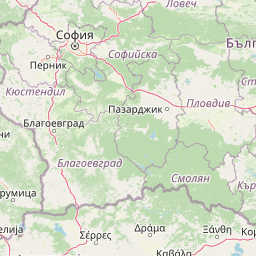
Mapping regional jurisdiction and national placement in Bulgaria
Interactive protected-area geometry and calculated area metrics
Vertical relief metrics and recorded natural features within the park
Peaks
2,348 m
Streams
Peaks
1,972 m
Streams
Peaks
2,261 m
Rivers
Temperate climate zones, montane relief, and major forest cover
Mountains · Forest · Lakes · Rivers · Glacier
Temperate broadleaf forest · Montane forest · Alpine meadow · Riverine habitat · Lacustrine habitat
Compare other national parks and protected landscapes across the Balkan Peninsula, tracing regional spread and adjacent mountain geography.
South

Explore Pirin National Park's mapped boundaries and landscape.
Pirin National Park serves as a vital national park entity within the atlas of Blagoevgrad Province, Bulgaria. This page details its protected landscape, offering a structured view of its geographic setting and mapped terrain. Users can investigate the park's specific identity and its relation to the surrounding regional geography, providing essential context for understanding protected areas and natural landscapes within a comprehensive map-driven framework.
Northeast
Explore mapped alpine terrain and ancient forests in Lovech Province.
Central Balkan National Park is a significant protected area in Bulgaria, renowned for its stunning mountain geography and exceptionally well-preserved ancient beech forests. Located within Lovech Province, the park's landscape is defined by dramatic peaks, including Botev Peak, deep canyons, and alpine meadows, offering a rich context for geographical exploration and understanding its protected status. Its ecosystem health and ecological value are underscored by multiple nature reserves and its recognition as part of a UNESCO World Heritage Site.
South

A significant reservoir within a mountain-framed basin
Lake Kerkini functions as a vital wetland habitat in the Central Macedonia region of Greece. Created as a reservoir along the Strymon River, it serves as a central waypoint for migratory species while providing a structured landscape of water, reed beds, and riverside forest. This atlas entry covers its geographic boundaries and its character as a working ecosystem shaped by both natural features and agricultural heritage.
Northwest

Discover its mountain lake ecosystem and mapped natural landscape.
Vlasina Ramsar Wetland is a critical protected area in Serbia, notable for its high-altitude mountain lake and river ecosystem within the Rhodopian Mountains. This page details its mapped geographic boundaries, unique terrain, and protected landscape identity, offering users a focused atlas exploration of a significant natural site. Delve into the specific geography and conservation context that define this internationally recognized wetland.
Southeast
Mapped boundaries, old-growth ecosystems, and Balkan geography.
Rodopi Mountain Range National Park is a critical protected forest area in Greece, safeguarding one of Europe's last primeval forests, the Frakto Virgin Forest. As the nation's largest woodland conservation site, it showcases remarkable biodiversity and complex mountain terrain, from low-lying forests to subalpine meadows. This page provides detailed mapping context and geographic specifics for understanding this unique protected landscape and its ecological significance within the Rhodope Mountains.
Northwest
Mapped protected landscape and regional geography discovery
Stara Planina National Park is a newly established national park in eastern Serbia, notable for its extensive mountain terrain and designation within the Balkan Mountains. This protected area features the distinctive Kopren plateau, Tupavica waterfall, and rugged landmarks, all contributing to its unique geographic identity. MoriAtlas provides a structured atlas view of Stara Planina National Park, detailing its protected boundaries and landscape context for comprehensive discovery.

South
Protected wetland basins and river gorge terrain in northern Greece
Spanning 159 square kilometers, this national park protects essential Mediterranean wetland habitats. Examine the unique intersection of Lake Korónia, the expansive Lake Vólvi, and the Richios River gorge that shapes the ecological character of this prominent Macedonian protected area.
Northwest
Mapping the unique limestone cliffs and river valley terrain.
Delve into the atlas details of Sićevo Gorge, a protected landscape in Serbia defined by its spectacular limestone cliffs and the Nišava River canyon. This page provides a structured overview of its dramatic topography, intricate karst formations, and the regional geographic context. Understand the mapped boundaries and the unique geological character that makes this gorge a standout feature in Serbia's natural landscape.
Deepen your understanding of Rila National Park by delving into its specific geographic context and protected landscape attributes. This page serves as a gateway to appreciating the mapped features, alpine terrain, and unique ecosystems that define this significant national park. Continue your atlas exploration to uncover the detailed cartography and regional significance of Rila National Park within Bulgaria's natural heritage.