
Mori Atlas logo
Nature reserveRiserva naturale dei Monti Pelati

Discover the rare peridotite ridge and specialized plant communities of this protected Italian nature reserve.

Riserva naturale dei Monti Pelati: An Exploration of Geological Diversity in Piemonte

Riserva naturale dei Monti Pelati preserves a striking geological contrast within the Piedmont region of northern Italy. Spanning 146 hectares, this protected area features a unique ridge of bare peridotite rock that creates chemically extreme soils. These conditions support rare plant species endemic to the Western Alps, distinguishing this landscape from the surrounding glacial moraines of the Canavese area.

nature reservePiedmontCanaveseperidotite geologyultrabasic soilsendemic flora
Vector-style flat illustration of a deep canyon with rocky vertical cliffs, a winding river, and forested hills under a light sky.

Riserva naturale dei Monti Pelati

Nature reserve

Park overview

Structured park overview, official facts, and landscape profile for Monti Pelati Nature Reserve

Monti Pelati Nature Reserve park facts, protected area profile, and essential visitor context

Review the core facts for Monti Pelati Nature Reserve, including designation, size, terrain, visitor scale, habitats, and operating context in one park-focused overview.

About Monti Pelati Nature Reserve

Monti Pelati Nature Reserve is a compact but scientifically significant protected area in northwestern Italy, lying in the Canavese region of Piedmont between the municipalities of Baldissero Canavese, Castellamonte, and Vidracco. Although its surface area is small, only around 146 hectares, the reserve captures a landscape and ecological profile that is highly distinctive within the Alps and within Italy more broadly.

The reserve protects a narrow band of bare, scrubby hills that locals have long called Monti Pelati, meaning bare mountains, or Monti Bruciati, meaning burnt mountains. These names reflect the arid, exposed appearance of the slopes, which contrast with the lusher surroundings. The ridge runs for roughly three kilometers in a southwest to northeast direction and ends at its highest point near the historic Torre Cives, where the elevation reaches about 585 meters above sea level. From the ridge, visitors can compare the reserve's unusual geology with the nearby Ivrea Morainic Amphitheater, a famous glacial landform, even though the two landscapes were shaped by entirely different processes.

Geologically, the reserve is its most striking feature. The bedrock of the Monti Pelati is peridotite, a dense, dark, ultrabasic igneous rock rich in magnesium and originating from the upper mantle, geologically tied to the African mantle domain. In most parts of the Alps, such mantle rocks lie deep underground; at Monti Pelati, they have been pushed to the surface and exposed by tectonic processes. As the peridotite weathers, it produces chemically unusual soils that are poor in nutrients and unsuitable for traditional agriculture, which is one reason the slopes remained free of farming and maintained their characteristic barren look.

These unusual soils are not a deficit from an ecological perspective. They have favored the establishment of plant communities, including several xerophilous and rare species, that would not survive on more typical alpine substrates. The reserve's biological importance led to its inclusion in the European Natura 2000 network, and it is now formally protected as a Site of Community Importance and Special Area of Conservation under the name Monti Pelati e Torre Cives. Managed by the Metropolitan City of Turin, the reserve serves as both a small regional natural area and a reference site for geological and botanical research in the western Alps.

Quick facts and research context for Monti Pelati Nature Reserve

Monti Pelati Nature Reserve is a provincially managed natural area located in the Canavese district of the Metropolitan City of Turin, in Piedmont. It was established in 1993 by the Piedmont Region and covers about 146 hectares across the municipalities of Baldissero Canavese, Castellamonte, and Vidracco.

The reserve coincides with the Natura 2000 Site of Community Importance and Special Area of Conservation known as Monti Pelati e Torre Cives (code IT1110013). Its territory consists of a single southwest to northeast oriented ridge culminating at roughly 585 meters near Torre Cives. The rock substrate is peridotite, giving the area its rare plant communities, including the endemic Campanula bertolae.

Protection and recognition

Documented terrestrial protection scope and official records for this reserve

Riserva naturale dei Monti Pelati Protection Status and Mapped Geography

Riserva naturale dei Monti Pelati maintains a documented terrestrial protection scope cataloged within official global databases. Official records outline the baseline conservation framework and management parameters associated with this protected landscape.

Protection details

Protection scope
Terrestrial
Transboundary protection
No
WDPA ID
161933
Park context

Deeper park guide and search-rich context for Monti Pelati Nature Reserve

Monti Pelati Nature Reserve history, landscape, wildlife, and travel context

Explore Monti Pelati Nature Reserve through its history, landscape character, ecosystems, wildlife, conservation priorities, cultural context, and seasonal travel timing in a structured park guide built for atlas discovery and search intent.

Why Monti Pelati Nature Reserve stands out

Monti Pelati is best known for being one of the few protected areas in the western Italian Alps built on peridotite, an ultrabasic mantle-derived rock that creates chemically extreme, magnesium-rich soils. This unusual geology is the reason the hills remain bare and uncultivated, and the reason they host a specialized flora that includes Campanula bertolae, a plant endemic to the Western Alps, along with other xerophilous species such as Linum suffruticosum and Fumana procumbens. The reserve is also recognized for its conservation status within the European Natura 2000 network, where the area is designated both as a Site of Community Importance and as a Special Area of Conservation under the name Monti Pelati e Torre Cives. Together, the geological oddity and the resulting biological specialization give the reserve a scientific value that goes well beyond its modest size.
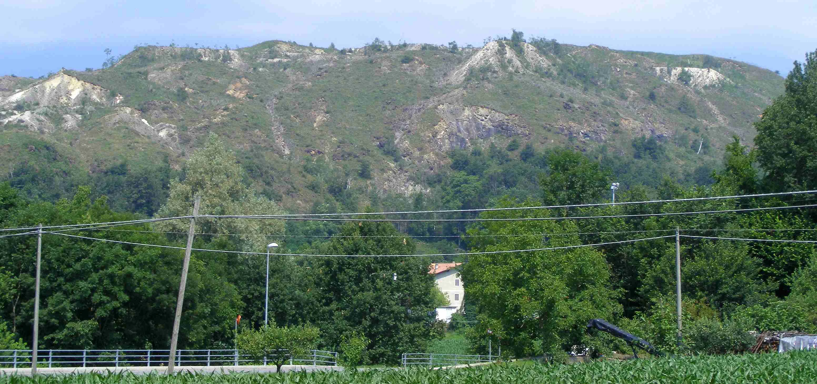
A wide shot of a green, rolling mountain slope featuring exposed rocky outcrops, seen behind a foreground of trees, power lines, and agricultural fields.
A view of the Monti Pelati in Baldissero Canavese, Italy.

Monti Pelati Nature Reserve history and protected-area timeline

The Monti Pelati ridge was not protected as a nature reserve until the end of the twentieth century, even though its unusual character attracted scientific attention earlier. A 1989 conference held at Parella, in the Canavese district, brought together specialists who discussed the landscape and scientific importance of the Monti Pelati di Baldissero, helping to build the case that the area deserved formal protection.

The reserve itself was then established in 1993 by the Piedmont Region through Regional Law 29 of 14 June 1993. The new protected area covered approximately 146 hectares across the municipalities of Baldissero Canavese, Castellamonte, and Vidracco, and was placed under provincial management, a responsibility that today rests with the Metropolitan City of Turin following Italy's administrative reforms.

In parallel, the area was recognized at the European level when it was designated as a Site of Community Importance under the Natura 2000 framework, with the identifier IT1110013. It subsequently became a Special Area of Conservation under the name Monti Pelati e Torre Cives, reflecting the ecological importance of both the geological substrate and the wildlife communities that depend on it.

Monti Pelati Nature Reserve landscape and geographic character

The landscape of Monti Pelati is shaped first and foremost by its geology. A narrow chain of bare, steep, sun-exposed hills forms the backbone of the reserve, running for about three kilometers in a roughly southwest to northeast orientation. The ridge never reaches alpine heights; its highest point sits at around 585 meters above sea level near the hilltop site of Torre Cives. Instead of forested mountain slopes, the reserve presents an austere, semi-arid scene of rocky ground, sparse scrub, and exposed peridotite boulders that reflect heat from the sky.

This character is dramatically different from the surrounding territory. Just to the north lies the Ivrea Morainic Amphitheater, one of the most famous glacial landform complexes in Italy, built from sediment left by a large Pleistocene glacier. The contrast between smooth glacial moraines and the jagged, mineral-rich hills of Monti Pelati is one of the most striking features a visitor can observe in this part of Piedmont.

The terrain of the reserve is also constrained by its soil chemistry. Peridotite weathers into substrates low in calcium and high in magnesium and heavy metals, conditions that farmers have historically avoided. This is one reason the surface of the reserve remained free of cultivation for centuries, allowing the bare hillsides and unique plant communities to survive in a region otherwise dominated by vineyards, fields, and small towns.

Monti Pelati Nature Reserve ecosystems, habitats, and plant life

The most defining feature of Monti Pelati's natural environment is its unusual soil system. The peridotite bedrock produces substrates that are chemically extreme: rich in magnesium and certain heavy metals, poor in conventional plant nutrients, and prone to drought-like conditions even in a humid alpine climate. As a result, the reserve supports plant communities that are unusually xerophilous, that is, adapted to dry conditions, and that resemble fragments of Mediterranean or steppe-like vegetation more than the typical forests of the western Alps.

The vegetation on the slopes is sparse and patchy, leaving much of the rocky ground visible and giving the area its distinctive barren appearance. Despite the harsh conditions, this habitat has become a refuge for species that would be outcompeted on more fertile soils. The reserve is therefore ecologically valuable as an island of specialized flora within a wider region of more typical Piedmont habitats.

Because of this combination of rare geology and unusual flora, the area has been integrated into the Natura 2000 network as both a Site of Community Importance and a Special Area of Conservation. The designation reflects the understanding that preserving this small pocket of ultrabasic habitat helps protect ecological processes and species that are not well represented elsewhere in the European protected-area system.

Monti Pelati Nature Reserve wildlife and species highlights

Information about the wildlife of Monti Pelati is most specific regarding insects. The source material highlights that the reserve supports a peculiar entomofauna, an insect community, tied directly to the unusual vegetation growing on the peridotite soils. Because such ultrabasic substrates are rare in the Alps, the insect populations adapted to them are also geographically restricted, which adds to the conservation value of the area.

Beyond this entomological interest, the reserve's mosaic of bare rock, low scrub, and small wooded patches is likely to host typical fauna of Piedmont's lower hill country, including small mammals, reptiles, and birds associated with open and edge habitats. However, the available sources do not provide detailed species lists, so the reserve's wildlife narrative is best understood as a story of habitat specialization rather than as a list of charismatic animals.

Monti Pelati Nature Reserve conservation status and protection priorities

The conservation significance of Monti Pelati rests on three connected elements: a rare geological substrate, the unusual soils that flow from it, and the specialized plant and insect communities those soils support. Because ultrabasic peridotite outcrops are uncommon in the Alps, especially where they are exposed at the surface, the reserve preserves an ecological context that cannot be easily replaced if lost.

Formally, the area is recognized at the European level through its inclusion in the Natura 2000 network. It is listed as a Site of Community Importance and a Special Area of Conservation under the designation Monti Pelati e Torre Cives, with the site code IT1110013. This designation obligates Italy and the managing authority to maintain the favorable conservation status of the habitats and species for which the site was chosen.

At the regional and local level, the reserve has been managed since its 1993 establishment by the provincial authorities, now the Metropolitan City of Turin. The lack of intensive historical land use, especially the absence of cultivation on the peridotite slopes, has been a quiet but decisive factor in keeping the area ecologically intact. Continuing this balance between limited access, scientific monitoring, and protection of the fragile soils remains the core conservation challenge for the reserve.

Monti Pelati Nature Reserve cultural meaning and human context

Monti Pelati has a small but distinct place in local Canavese culture. The traditional names for the hills, Monti Pelati (bare mountains) and Monti Bruciati (burnt mountains), reflect how local communities long perceived these arid, rocky slopes as something out of the ordinary within the surrounding agricultural landscape. These names are now embedded in the official identity of the protected area and the Natura 2000 site that overlaps it.

The reserve has also left a modest mark on Italian cinema. In 1998, the short film Il solitario dei Monti Bruciati, directed by Federico Jahier, was produced on location in the area and presented at the Festival Cinema Giovani in Turin. While the reserve is not a major cultural landmark, the film is a reminder that the unusual scenery of the Monti Pelati has drawn artistic attention alongside scientific interest.

The hilltop of Torre Cives, which gives its name to the Natura 2000 site, also carries historical and visual significance as a landmark above the Canavese plain, even though the reserve's own mandate is focused on natural rather than built heritage.

Top sights and standout views in Monti Pelati Nature Reserve

Monti Pelati's strongest points of distinction are geological and botanical rather than scenic in the conventional sense. Its peridotite bedrock, originating from the upper mantle and tied to the African mantle structure, is rare in the Alps and is the foundation for the entire protected area. From this bedrock flow the unusual soils, the bare hillsides, and the specialized flora that includes the Western Alps endemic Campanula bertolae along with xerophilous species like Linum suffruticosum and Fumana procumbens.

The reserve's small size is also one of its strengths. At roughly 146 hectares, it offers a focused, easily understood example of how geology shapes ecology. The combination of regional protection since 1993, Natura 2000 status, and a scenic contrast with the nearby Ivrea Morainic Amphitheater makes Monti Pelati a compact but informative site for visitors interested in the geological and biological diversity of the western Italian Alps.

Best time to visit Monti Pelati Nature Reserve

The sources do not provide detailed seasonal guidance, but the character of Monti Pelati suggests that spring and early summer offer the richest window for viewing the specialized plant communities that give the reserve its botanical significance. During these seasons, the xerophilous and endemic flora on the peridotite slopes is most active, while the bare rocky landscape remains visually striking.

Late summer and autumn can be drier, with the arid look of the hills even more pronounced, which may suit visitors focused on geology and landscape character rather than flowering displays. Winters are generally mild for the elevation but may include cooler conditions and reduced visibility of the flora. Because the reserve is on a compact ridge rather than a high alpine zone, it is broadly accessible through much of the year, though visitors should generally expect terrain that rewards comfortable walking shoes and an interest in subtle ecological detail rather than dramatic mountain scenery.

Monthly climate preview

Long-term temperature and precipitation averages across the protected terrain

Riserva naturale dei Monti Pelati Climate Normals and Weather by Month

Representative coordinate records show measured annual temperature ranges alongside monthly precipitation rates for Riserva naturale dei Monti Pelati. Examining the complete twelve-month climatology profile provides deeper context for long-term regional weather patterns.
Annual mean6 °C
-4 °C16 °C
Jan-4°
Feb-3°
Mar
Apr
May
Jun14°
Jul16°
Aug15°
Sep11°
Oct
Nov
Dec-3°
Warmest month
July

15.7 °C

Coolest month
January

-4.1 °C

Wettest month
May

3.2 mm/day

Driest month
January

1.5 mm/day

Park location guide

Geography guide, regional context, and park location map for Monti Pelati Nature Reserve

Monti Pelati Nature Reserve park geography, regions, and map view in Italy

Understand where Monti Pelati Nature Reserve sits in Italy through a broader geographic reading of the surrounding landscape, nearby location context, and its mapped position within the national park landscape.

How Monti Pelati Nature Reserve fits into Italy

Italy is a unitary parliamentary republic in Southern and Western Europe, located on the Italian Peninsula with the Alps to the north. It borders France, Switzerland, Austria, Slovenia, Vatican City, and San Marino, and shares maritime boundaries with several Mediterranean countries. The country has approximately 59 million residents and uses the Euro as its currency.

Wider geography shaping Monti Pelati Nature Reserve in Italy

Italy occupies a boot-shaped peninsula in southern Europe, bordered by the Alps to the north. It shares land borders with France, Switzerland, Austria, Slovenia, Vatican City, and San Marino. The country includes the Mediterranean islands of Sicily and Sardinia, along with approximately 800 smaller islands.

Map view of Monti Pelati Nature Reserve

Use this park location map to pinpoint Monti Pelati Nature Reserve in Italy, understand its exact geographic position, and read its mapped placement within the surrounding landscape more clearly.

Pigeon | © OpenStreetMap contributors

Location context for Monti Pelati Nature Reserve

Piemonte

Visual reference of peridotite terrain, bare ridges, and protected habitats in Piedmont

Riserva naturale dei Monti Pelati Photos and Landscape Scenery

Visual records capture the rugged topography, exposed peridotite boulders, and sparse scrub defining the protected ridge of Riserva naturale dei Monti Pelati. Photographic documentation reveals the distinct geological character and specialized flora differentiating these alpine foothills from surrounding glacial terrain.

A wide shot of a green, rolling mountain slope featuring exposed rocky outcrops, seen behind a foreground of trees, power lines, and agricultural fields.

A low-angle view of rugged, pale rocky hills at Monti Pelati, with sparse green shrubs and grasses on the slopes under a hazy sky.

Park atlas

Compare adjacent regional landscapes and connected alpine foothill reserves.

Exploring Parks Near Riserva Naturale dei Monti Pelati and Surrounding Protected Areas

Browse other protected areas and nearby national parks to compare surrounding regional geography after examining Riserva naturale dei Monti Pelati. Reviewing connected terrain helps place specialized mantle-derived geology and rare foothill habitats within a broader alpine context.
Watercolor illustration depicting green valleys, forests, and distant mountain peaks
National parkItaly
About 18 km away#1 closest

West

Gran Paradiso National Park: Italy's National Park Protected Landscape Atlas

Mapped boundaries and regional geography for a key Italian protected area.

Gran Paradiso National Park is a distinct national park entity within Italy, offering rich potential for atlas-driven geographic discovery. This MoriAtlas profile focuses on its protected landscape identity, providing essential context for understanding its mapped boundaries and its role within the regional geography of Italy. Explore the structured geographic details that make Gran Paradiso National Park a valuable component of any mapped landscape analysis.

Area
703 km²
Established
1922
IUCN
II
Relief
Mountain
A watercolor painting showing a soft-focus, panoramic landscape with green trees, gentle hills, a central body of water, and pale mountains in the background against a white backdrop.
Nature reserveBiella
About 22 km away#2 closest

East

Riserva naturale speciale della Bessa: Protected Nature Reserve in Northern Piedmont

Glacial moraines and archaeological mining landscapes near Biella

Located in the foothills of the Alps, the Riserva naturale speciale della Bessa is defined by its austere, stone-filled plateau. This nature reserve offers a unique look at Pleistocene glacial deposits and the extensive traces of Roman placer gold extraction. The geography includes erratic boulders, deep erosional channels, and historic terrace systems that reveal a deep connection between ancient labor and natural geological forces.

Area
7.5 km²
Established
2009
IUCN
IV
Watercolor painting depicting mountains, a river, and trees under a light sky
National parkSavoie
About 44 km away#3 closest

West

Vanoise National Park: Explore France's Original National Park in the Savoie Alps

Mapped Alpine geography, glacial terrain, and protected landscape.

Vanoise National Park is France's pioneering national park, a protected landscape of immense alpine beauty situated in the Savoie department. Renowned for its dramatic glacial terrain, over 100 peaks above 3,000 meters, and the iconic Alpine ibex, this park offers a profound geographic context. Explore its mapped boundaries and discover the unique atlas-level insights into France's mountainous protected areas and their ecological significance.

Area
534 km²
Established
1963
IUCN
II
Relief
Mountain
Nature reservePiemonte
About 52 km away#4 closest

East

Riserva naturale speciale dell'Isolone di Oldenico: Geography and Riverine Conservation Atlas

Protected riparian corridors in the Po Plain region of Northern Italy

This nature reserve preserves a distinct island feature formed by the Sesia river system. As a vital component of the lower Sesia valley network, the protected area contrasts sharply with the surrounding agricultural land by maintaining indigenous riverine vegetation, marshy habitat pockets, and natural levees within the flat terrain of the Province of Vercelli.

Area
0.52 km²
Established
1978
IUCN
IV
A soft watercolor illustration depicting rolling green hills, a small winding river, and a light-filled sky, set against a white background.
Nature reservePiemonte
About 60 km away#5 closest

Northeast

Riserva speciale del Sacro Monte di Varallo: Nature Reserve and Woodland Geography

Exploring the protected boundaries and forest terrain in Piemonte

Riserva speciale del Sacro Monte di Varallo is a compact nature reserve in the Piedmont region, distinguished by its Renaissance-inspired woodland and elevation above the Valsesia valley. This protected landscape combines ecological richness with historic chapel architecture, offering a study in the intersection of natural terrain, cultural heritage, and Alpine foothill geography.

Area
0.217 km²
Established
1990
IUCN
V
Relief
Upland
Watercolor illustration showing green mountains, forests, a river, and snow-capped peaks in the distance
National parkPiedmont
About 78 km away#6 closest

Northeast

Val Grande National Park: National Park Protected Landscape in Piedmont

Explore its mapped boundaries and regional geographic context.

Val Grande National Park represents a key protected landscape within the Piedmont region of northwest Italy. This canonical page offers detailed insights into the park's designated status as a national park, its specific geographic placement, and its mapped protected boundaries. Users can navigate its atlas-level details to understand its role in the regional geography and conservation landscape, providing a structured foundation for further discovery of Italy's natural protected areas.

Area
170.21 km²
Established
1992
IUCN
II
Relief
Mountain
Watercolor painting of green hills and distant pale mountain peaks against a soft pinkish sky.
Nature reserveHaute-Savoie
About 92 km away#7 closest

Northwest

Réserve naturelle nationale du Vallon de Bérard: Geography and Protected Alpine Terrain

High-altitude glacial valleys and crystalline peaks of Haute-Savoie

Situated in the heart of the Aiguilles Rouges massif, Réserve naturelle nationale du Vallon de Bérard preserves a compact mosaic of high-mountain ecosystems. From the Eau de Bérard torrent to the crystalline needles of Aiguille du Belvédère, the reserve provides a protected refuge for alpine species and a rare look at relict glacial landscapes within the French Alps.

Area
5.397 km²
Established
1992
IUCN
IV
Relief
Mountain
A horizontal watercolor painting showing a soft alpine meadow with a stream running through it, framed by distant rolling mountains and patches of trees.
Regional parkPiemonte
About 94 km away#8 closest

Southwest

Pian del Re Regional Park: Geography and Alpine Protected Landscapes in Piemonte

Glacial springs, peat bogs, and Monviso mountain terrain

Pian del Re is a significant regional park situated in the upper Po Valley of the Cottian Alps. Known for its high-altitude plateau, the area marks the origin of the Po River and hosts sensitive wetland habitats. The landscape is defined by the sharp relief of the Monviso group and a complex network of glacial meltwater, providing a distinct study in alpine ecology and mountain geography.

Relief
Mountain
Climate
Alpine
Access
Moderate access
Scope
Terrestrial

Common questions about visiting, size, designation, and location context for Monti Pelati Nature Reserve

Monti Pelati Nature Reserve FAQs for park facts, access, geography, and protected area context

Find quick answers about Monti Pelati Nature Reserve, including protected-area facts, park geography, trail and visitor context, and how the park fits into its surrounding country and regional landscape.
MoriAtlas Explorer

Continue Your Protected Areas Search Across the Global Atlas

Deepen your exploration by continuing the structured search for national parks and protected areas worldwide. Utilize the comprehensive filtering capabilities to compare different conservation landscapes and refine your understanding of global park geography. Discover more about the distribution and characteristics of protected natural areas.

Global natural geography