
Mori Atlas logo
Nature reserveRiserva naturale regionale Marina di Vasto

A vital protected landscape in Abruzzo, preserving delicate dune and wetland ecosystems

Riserva naturale regionale Marina di Vasto: Mapping a Rare Adriatic Coastal Nature Reserve

The Riserva naturale regionale Marina di Vasto acts as a crucial ecological anchor along the Adriatic coast of Italy, protecting a narrow but diverse transition zone where beach, dune, and brackish wetland habitats converge. Stretching through the Abruzzo region, this protected area preserves remnants of original coastal terrain amidst an otherwise developed shoreline. The landscape offers a detailed study in coastal geography, featuring psammophilous flora and aquatic habitats shaped by the interaction of stream outlets and marine influence.

coastal reserveAdriatic coastdune ecosystemwetlandsbrackish habitatsMediterranean flora

Riserva naturale regionale Marina di Vasto

Nature reserve

Park overview

Structured park overview, official facts, and landscape profile for Riserva Naturale Regionale Marina di Vasto

Riserva Naturale Regionale Marina di Vasto park facts, protected area profile, and essential visitor context

Review the core facts for Riserva Naturale Regionale Marina di Vasto, including designation, size, terrain, visitor scale, habitats, and operating context in one park-focused overview.

About Riserva Naturale Regionale Marina di Vasto

The Riserva Naturale Regionale Marina di Vasto occupies a narrow but ecologically rich band of the central-southern Adriatic coast in Italy. Although it spans only about 57 hectares and roughly 3 kilometers in length, the reserve compresses several distinct coastal ecosystems into a compact footprint. On the seaward side lies the Adriatic beach, while inland the protected zone meets the built-up coastal strip of Marina di Vasto, the Adriatic railway line, and eventually the historic core of Vasto perched above the cliff edge.

The landscape of the reserve reflects this transitional geography. Sand dunes and psammophilous plant communities line the shore, grading into moist and brackish habitats near the mouths of the Buonanotte stream and the San Tommaso ditch. These small watercourses, fed by the surrounding hills including Monte Vecchio and the Selvotta and Aglavizza ridges, sustain patches of freshwater and halophytic vegetation. Behind the dunes, agricultural fields with scattered woodland nuclei and small settlements continue toward the edge of the urban fabric, while the eastern beach area accommodates a number of bathing establishments.

Ecologically, the reserve represents a classic ecotone, where dune species, wetland species, and Mediterranean species overlap. The EU Natura 2000 designation recognizes the area's role in maintaining coastal habitat connectivity along an otherwise heavily developed stretch of the Adriatic. Managed by the Municipality of Vasto, the reserve also integrates recreational and educational uses, with the Adriatic cycle route passing through it and proximity to the Mediterranean botanical garden near the Buonanotte stream.

Quick facts and research context for Riserva Naturale Regionale Marina di Vasto

The Riserva Naturale Regionale Marina di Vasto is a regional nature reserve of about 57 hectares, located in the municipalities of Vasto and San Salvo within the Province of Chieti, in the Abruzzo region of Italy. Established through regional law in March 2007, it is classified under the EUAP system as an Italian protected natural area and is part of the Natura 2000 network as both a Site of Community Importance and a Special Area of Conservation. The reserve protects a 3-kilometer stretch of Adriatic coastline and is managed by the Municipality of Vasto.

Protection and recognition

Documented terrestrial protection scope, designation year, and international recognition facts

Riserva Naturale Regionale Marina Di Vasto Protection Status And Designation History

Riserva naturale regionale Marina di Vasto carries a documented terrestrial protection status established in 2007. Review the complete designation history, management scope, and official recognition records associated with this protected area.

Protection details

Protection scope
Terrestrial
Designated year
2007
Transboundary protection
No
Park context

Deeper park guide and search-rich context for Riserva Naturale Regionale Marina di Vasto

Riserva Naturale Regionale Marina di Vasto history, landscape, wildlife, and travel context

Explore Riserva Naturale Regionale Marina di Vasto through its history, landscape character, ecosystems, wildlife, conservation priorities, cultural context, and seasonal travel timing in a structured park guide built for atlas discovery and search intent.

Why Riserva Naturale Regionale Marina di Vasto stands out

The reserve is best known for protecting one of the last surviving stretches of natural and semi-natural Adriatic beach in Abruzzo. Its narrow coastal strip preserves a rare ecological transition zone where dune habitats, brackish wetlands fed by small streams, and Mediterranean vegetation coexist within a heavily developed coastline. The presence of specialized dune flora, wetland plants, and aquatic fauna, including the European pond turtle, gives the area a strong ecological identity despite its modest size.
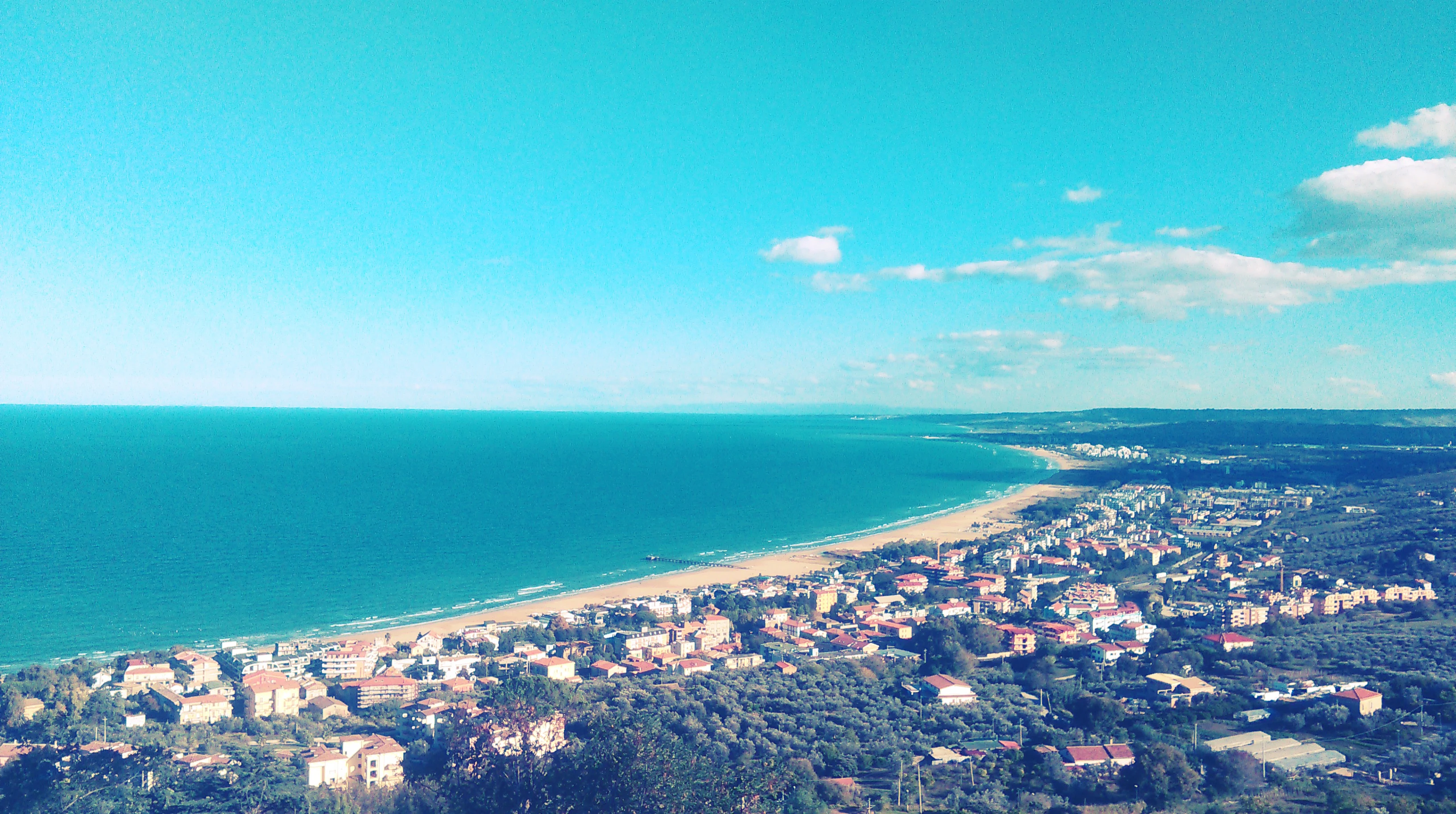
A wide landscape view of a coastal town along a long sandy beach next to a large body of blue water under a bright blue sky with scattered clouds.
A panoramic view of the coastline at Marina di Vasto, showing the sandy beach, the Adriatic Sea, and the coastal town.

Riserva Naturale Regionale Marina di Vasto history and protected-area timeline

The Riserva Naturale Regionale Marina di Vasto was formally established on 30 March 2007 through Regional Law No. 5 of the Abruzzo Region, which created it as a regional nature reserve. From its inception, the area was recognized within the framework of the European Natura 2000 network, designated as both a Site of Community Importance and a Special Area of Conservation, reflecting its ecological value at the European level.

The reserve was conceived as a tool to safeguard a remaining fragment of natural and semi-natural coastline along the Adriatic, much of which had otherwise been transformed by urban development, tourism infrastructure, and railway construction. Its creation placed the existing dune systems, wetland patches, and the transitional habitats surrounding the local streams under formal protection, while assigning overall management responsibility to the Municipality of Vasto.

Riserva Naturale Regionale Marina di Vasto landscape and geographic character

The reserve's landscape is a narrow coastal ribbon shaped by the dynamics of sea, dune, and inland waters. The protected strip runs roughly 3 kilometers along the Adriatic, with an average width of about 180 meters, bounded on the seaward side by open sea and on the landward side by the developed Marina di Vasto area and the Adriatic railway line. To the south-west, the terrain transitions into farmland, small wooded patches, and dispersed rural settlements before reaching the edge of Vasto's historic center, which rises along the coastal cliff.

The shoreline hosts dune formations supporting specialized psammophilous vegetation adapted to salt spray, drought, and shifting sands. Inland, the Buonanorte stream and the San Tommaso ditch carve shallow valleys into the coastal plain, creating small humid depressions and brackish zones where fresh water meets marine influence. The combination of rolling agricultural land, scattered woodland, river mouths, dune ridges, and the elevated cliff edge on which Vasto sits gives the reserve a layered coastal scenery compressed into a small area.

Riserva Naturale Regionale Marina di Vasto ecosystems, habitats, and plant life

Ecologically, the Marina di Vasto reserve represents a textbook example of a coastal ecotone, where marine, dune, wetland, and Mediterranean terrestrial habitats meet. The dunes support a community of psammophilous plants including species such as sea spurge, sea bindweed, and beach grasses, which grow in cushion-like forms adapted to the harsh, shifting substrate. Near the streambeds and in the brackish depressions, hygrophilous and halophytic vegetation replaces the dune flora, creating a mosaic of freshwater and saline-influenced plant communities within a very short distance.

The botanical diversity of the reserve also reflects the influence of the Mediterranean botanical garden located near the Buonanorte stream, at the border between Vasto and San Salvo. Together, the dune, wetland, and garden areas support a distinctive range of plant communities that are increasingly rare along the heavily developed Abruzzo coast.

Riserva Naturale Regionale Marina di Vasto wildlife and species highlights

Wildlife in the Marina di Vasto reserve is closely tied to the wetland and dune habitats that the reserve protects. Aquatic and moisture-dependent birdlife uses the brackish and freshwater zones created by the Buonanorte stream and the San Tommaso ditch, while dune-adapted species find refuge in the remaining natural beach and foredune areas. The reserve's position along the Adriatic flyway gives it particular relevance for waterbirds and other coastal fauna.

Among the most notable resident species is the European pond turtle, which inhabits the reserve's wetland margins. The combination of reptiles, waterbirds, and invertebrates associated with humid dune habitats gives the area a small but ecologically coherent faunal community, sustained by the same transitional conditions that drive its botanical diversity.

Riserva Naturale Regionale Marina di Vasto conservation status and protection priorities

From a conservation perspective, the reserve matters primarily because it preserves a fragment of natural coastline in a region where most of the Adriatic shore has been modified for tourism, transport, and urban growth. Its inclusion in the Natura 2000 network as a Site of Community Importance and a Special Area of Conservation underscores its value for habitat protection at the European scale, particularly for dune ecosystems, coastal wetlands, and the transitional habitats linking them.

The reserve's protected status also safeguards the ecological processes driven by the small local streams, including the formation of brackish wetlands and the maintenance of psammophilous plant communities. By maintaining these habitats in continuity, the reserve helps preserve ecological connectivity along a coastal stretch otherwise fragmented by infrastructure, supporting both resident species and seasonal wildlife movements along the Adriatic.

Riserva Naturale Regionale Marina di Vasto cultural meaning and human context

The reserve is closely tied to the cultural geography of Vasto and San Salvo, two Adriatic towns with strong maritime identities. The historic center of Vasto sits along the coastal cliff above the protected shoreline, and its traditional relationship with the sea is an important part of the town's heritage. The Mediterranean botanical garden located near the Buonanorte stream, at the border between the two municipalities, reflects a long-standing local interest in Mediterranean plant cultivation and education.

The Adriatic cycle route that passes through the reserve also links the area to a broader regional culture of coastal travel, reconnecting the small urban centers of the Abruzzo coast through cycling and walking routes that follow the historic shoreline.

Top sights and standout views in Riserva Naturale Regionale Marina di Vasto

The reserve's most distinctive quality is the concentration of dune, wetland, and Mediterranean ecosystems within a single narrow coastal strip, making it a representative example of an Adriatic coastal ecotone. Its included position in the Natura 2000 network highlights its role in protecting dune habitats and coastal wetlands at the European level, while the presence of species such as the European pond turtle and a range of psammophilous plants reinforces its ecological identity. Combined with its setting between the towns of Vasto and San Salvo and the integration of the Adriatic cycle route, the reserve stands out as a compact but rich example of integrated coastal conservation in Italy.

Best time to visit Riserva Naturale Regionale Marina di Vasto

The reserve is shaped by a markedly continental climate pattern despite its coastal setting, with substantial annual thermal variation. Late spring and early summer tend to highlight the dune flora and bird activity, while the cooler months offer quieter conditions and a different atmospheric character along the Adriatic shoreline. Visitors interested in wetland birds, dune vegetation, or peaceful coastal walks generally find the shoulder seasons rewarding, when temperatures are milder and ecological detail is easier to observe.
Monthly climate preview

Representative temperature and precipitation averages recorded at benchmark coordinates

Riserva naturale regionale Marina di Vasto Climate Normals and Monthly Weather Patterns

Long-term NASA observations establish the baseline temperature and precipitation rhythm across twelve measured monthly intervals for Riserva naturale regionale Marina di Vasto. Examining the complete monthly climate profile reveals detailed thermal ranges and moisture variations recorded at this specific regional coordinate.
Annual mean17 °C
9 °C26 °C
Jan
Feb
Mar11°
Apr14°
May19°
Jun23°
Jul26°
Aug26°
Sep22°
Oct18°
Nov14°
Dec11°
Warmest month
August

26.4 °C

Coolest month
February

9.4 °C

Wettest month
November

2.2 mm/day

Driest month
July

0.9 mm/day

Park location guide

Geography guide, regional context, and park location map for Riserva Naturale Regionale Marina di Vasto

Riserva Naturale Regionale Marina di Vasto park geography, regions, and map view in Italy

Understand where Riserva Naturale Regionale Marina di Vasto sits in Italy through a broader geographic reading of the surrounding landscape, nearby location context, and its mapped position within the national park landscape.

How Riserva Naturale Regionale Marina di Vasto fits into Italy

Italy is a unitary parliamentary republic in Southern and Western Europe, located on the Italian Peninsula with the Alps to the north. It borders France, Switzerland, Austria, Slovenia, Vatican City, and San Marino, and shares maritime boundaries with several Mediterranean countries. The country has approximately 59 million residents and uses the Euro as its currency.

Wider geography shaping Riserva Naturale Regionale Marina di Vasto in Italy

Italy occupies a boot-shaped peninsula in southern Europe, bordered by the Alps to the north. It shares land borders with France, Switzerland, Austria, Slovenia, Vatican City, and San Marino. The country includes the Mediterranean islands of Sicily and Sardinia, along with approximately 800 smaller islands.

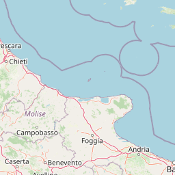
Map view of Riserva Naturale Regionale Marina di Vasto

Use this park location map to pinpoint Riserva Naturale Regionale Marina di Vasto in Italy, understand its exact geographic position, and read its mapped placement within the surrounding landscape more clearly.

Pigeon | © OpenStreetMap contributors

Location context for Riserva Naturale Regionale Marina di Vasto

Abruzzo

Visual exploration of Adriatic coastal dunes, brackish wetlands, and Mediterranean habitats

Riserva naturale regionale Marina di Vasto Photos, Landscape, and Scenery

Visual records capture the distinctive coastal terrain, shifting sand dunes, and brackish wetland habitats defining the reserve along the Adriatic shore. Examining field photography helps reveal the ecological transition zone where rare Mediterranean flora and specialized fauna thrive within a protected narrow ribbon.

A wide landscape view of a coastal town along a long sandy beach next to a large body of blue water under a bright blue sky with scattered clouds.

Park atlas

Compare adjacent coastal reserves, dune habitats, and regional nature parks

Parks Near Riserva Naturale Regionale Marina Di Vasto And Surrounding Protected Landscapes

Visitors exploring Riserva naturale regionale Marina di Vasto can discover other protected areas sharing similar coastal ecosystems, brackish wetlands, and Mediterranean terrain. Expanding the geographic comparison reveals broader regional conservation networks and adjacent natural reserves along the Adriatic coast.
Nature reserveAbruzzo
About 37 km away#1 closest

Northwest

Punta dell'Acquabella Nature Reserve: Adriatic Coastal Landscape and Geography

Protected Mediterranean shoreline in the Abruzzo region of Italy

Punta dell'Acquabella is a distinct nature reserve on the Adriatic coast of Abruzzo, characterized by its promontory, cliff habitats, and clear coastal waters. The area serves as a significant intersection of natural heritage and cultural landscape within the Trabocchi coast, offering a deep look into the regional geography and environmental features that define this protected territory.

Area
0.28 km²
Established
2007
Relief
Upland
Climate
Mediterranean
Watercolor painting showing mountains, forests, and a body of water in a scenic landscape
National parkAbruzzo
About 43 km away#2 closest

West

Maiella National Park: Abruzzo's Protected Landscape and Regional Geography

Explore mapped park boundaries and natural terrain.

Delve into the protected landscape of Maiella National Park, situated within the Abruzzo region of southern Italy. This page offers detailed atlas-level insights into its mapped boundaries, allowing for a clear understanding of its geographic setting. Discover how this national park contributes to the regional natural terrain and protected area context, providing a foundation for structured geographic exploration.

Area
628.38 km²
Established
1991
IUCN
II
Relief
Mountain
Watercolor illustration of a tree, green hills, and distant water view
National parkApulia
About 45 km away#3 closest

East

Gargano National Park: Apulia's Protected Landscape and Regional Geographic Context

Mapped boundaries and natural terrain of a key Italian national park.

Delve into Gargano National Park, a designated national park situated in the Apulia region of Italy. This protected landscape offers valuable insights into the geography of the Gargano promontory. Through MoriAtlas, users can explore its mapped boundaries, understand its terrain, and connect it to the broader regional geography of southern Italy, providing a solid foundation for protected-area discovery.

Area
1,181.44 km²
Established
1991
IUCN
II
Relief
Mixed relief
Watercolor painting of mountains, green valleys, and a river
National parkItaly
About 71 km away#4 closest

Northwest

Gran Sasso and Monti della Laga National Park: Italy's National Park Geographic Context

Mapped protected areas and regional natural landscape details.

Delve into the geography of Gran Sasso and Monti della Laga National Park, a prominent national park in Italy. This resource provides essential context for understanding its protected landscape, mapped boundaries, and integration within the regional geography. Ideal for users seeking detailed atlas-style information on protected areas and their natural terrain, it serves as a foundational point for exploring the park's unique geographic character and landscape significance.

IUCN
II
Watercolor painting showing a landscape with rolling green hills, a river, and scattered trees
National parkItaly
About 80 km away#5 closest

Southwest

Abruzzo, Lazio and Molise National Park

Protected landscape in Italy's Apennines.

Explore the mapped boundaries and protected status of Abruzzo, Lazio and Molise National Park. This historic Italian national park offers a detailed look at Apennine mountain geography and landscape.

Established
1923
IUCN
II
Watercolor illustration of a mountainous landscape with green hills, a valley with a river, and distant mountains under a pink and yellow sky
National parkCampania
About 138 km away#6 closest

South

Vesuvius National Park: Protected Volcanic Landscape in Campania, Italy

Explore mapped boundaries and regional geography.

Discover Vesuvius National Park, a vital protected area safeguarding Italy's iconic active volcano. This page provides essential geographic context, detailed mapped terrain, and insights into the park's unique volcanic landscape within the Campania region. It serves as a key entry point for understanding the park's protected status and its geological significance for structured atlas exploration.

Area
72.59 km²
Established
1995
IUCN
II
Relief
Mountain
Watercolor painting of a mountainous landscape with green and yellow terrain, distant mountains, and forests
National parkMarche
About 140 km away#7 closest

Northwest

Monti Sibillini National Park: National Park with Regional Geographic Context in Marche

Explore protected landscape boundaries and terrain.

Monti Sibillini National Park serves as a vital national park within the Marche region, offering a distinct natural landscape for geographic study. This entry provides essential context for understanding the park's mapped protected area status and its integration into the regional geography of central Italy. Delve into the park's specific setting, discovering how its terrain and protected status contribute to the atlas of Italian natural landscapes.

Area
697.22 km²
Established
1993
IUCN
II
Relief
Mountain
Watercolor illustration showing green grasslands, distant hills, and a winding path under a light sky
National parkItaly
About 153 km away#8 closest

Southeast

Alta Murgia National Park: National Park Exploration and Protected Landscape Context

Explore mapped terrain and regional geography.

Alta Murgia National Park is a designated national park offering unique opportunities for geographic discovery. Delve into its protected landscape, understand its mapped boundaries, and situate it within the broader Italian atlas. This entry provides essential context for exploring the park's terrain and regional significance.

Area
677.39 km²
Established
2004
IUCN
II
Relief
Mixed relief

Common questions about visiting, size, designation, and location context for Riserva Naturale Regionale Marina di Vasto

Riserva Naturale Regionale Marina di Vasto FAQs for park facts, access, geography, and protected area context

Find quick answers about Riserva Naturale Regionale Marina di Vasto, including protected-area facts, park geography, trail and visitor context, and how the park fits into its surrounding country and regional landscape.
MoriAtlas Explorer

Continue Your Protected Areas Search Across the Global Atlas

Deepen your exploration by continuing the structured search for national parks and protected areas worldwide. Utilize the comprehensive filtering capabilities to compare different conservation landscapes and refine your understanding of global park geography. Discover more about the distribution and characteristics of protected natural areas.

Global natural geography