Mori Atlas logo
National parkSamur-Yalama National Park

Discover mapped boundaries and diverse ecosystems within this significant Azerbaijani national park.

Samur-Yalama National Park: A Protected Caspian Coastal Landscape in Khachmaz Rayon

(Samur-Yalama Milli Parkı)

Samur-Yalama National Park, established in 2012, represents a key protected landscape situated in Azerbaijan's Khachmaz Rayon along the Caspian Sea coast. This national park spans approximately 11,772 hectares, safeguarding a unique mosaic of littoral zones dominated by deciduous forests, including chestnut oak and Persian ironwood, transitioning inland to steppe vegetation. Its geographic position within the Eastern Caucasus makes it a critical area for understanding regional biodiversity and conservation efforts, offering a rich context for atlas-based discovery of protected natural areas.

national parkcoastal forestCaspian Seadeciduous forestEastern Caucasusprotected area

Samur-Yalama National Park

National park

Park overview

Structured park overview, official facts, and landscape profile for Samur-Yalama National Park

Samur-Yalama National Park park facts, protected area profile, and essential visitor context
Review the core facts for Samur-Yalama National Park, including designation, size, terrain, visitor scale, habitats, and operating context in one park-focused overview.

About Samur-Yalama National Park

Samur-Yalama National Park occupies a distinctive position in Azerbaijan's protected area network as a coastal forest preserve in the country's northern Caspian region. The park's creation in 2012 reflected growing recognition of the ecological value of Azerbaijan's Caspian coastal zones, which had faced development pressures and habitat fragmentation. The protected area encompasses the largest portion of its territory within the Caspian coastal zone, where dense deciduous forests create a striking contrast to the more arid landscapes found further inland in Azerbaijan. The park serves multiple conservation objectives: preserving biological and genetic diversity across several unique natural habitats, protecting historical-cultural heritage sites within its boundaries, and developing sustainable eco-tourism opportunities for visitors. Some tourist routes originate from the settlement of Yalama, providing access to the park's interior landscapes. The park's management falls under Azerbaijan's Ministry of Ecology and Natural Resources, reflecting the national priority placed on conserving this coastal forest ecosystem.

Quick facts and research context for Samur-Yalama National Park

Samur-Yalama National Park spans roughly 11,772 hectares in Azerbaijan's Khachmaz Rayon along the Caspian Sea coastline. The park was established in 2012 through a presidential decree and is managed by Azerbaijan's Ministry of Ecology and Natural Resources. The protected area lies at the junction of several landscape types including coastal littoral zones, forested areas, forest-bush communities, and drier steppe habitats. Annual rainfall varies significantly across the park, with coastal areas receiving less than 350mm while inland zones experience over 450mm. Soils range from sandy coastal substrates to heavier clay compositions. The Samur River flows through the region, and the park includes the Gülalan lake area within its boundaries.

Park context

Deeper park guide and search-rich context for Samur-Yalama National Park

Samur-Yalama National Park history, landscape, wildlife, and travel context
Explore Samur-Yalama National Park through its history, landscape character, ecosystems, wildlife, conservation priorities, cultural context, and seasonal travel timing in a structured park guide built for atlas discovery and search intent.

Why Samur-Yalama National Park stands out

Samur-Yalama is notable for its coastal forest ecosystems along the Caspian Sea, where chestnut oak and Persian ironwood form the dominant tree communities. The park protects important habitat for several threatened species including the eastern imperial eagle and black kite among birds, while mammals such as lynx, brown bear, and Caspian red deer inhabit the more densely vegetated zones. The coastal waters support fish species of conservation and commercial significance including stellate sturgeon and Caspian kutum.

Samur-Yalama National Park history and protected-area timeline

Samur-Yalama National Park was established on November 5, 2012, through a presidential decree authorizing its creation within Khachmaz Rayon administrative territory. The park's establishment followed a period of growing environmental cooperation in the South Caucasus region, with funding support provided through a joint program between Azerbaijan's Ministry of Finance and KfW (Kreditanstalt für Wiederaufbau), the German development bank, as part of a broader ecoregional nature conservation initiative for the South Caucasus. The project framework involved financing agreements specifically directed toward establishing the park and fulfilling Azerbaijan's conservation commitments under the program. This international partnership approach reflected the transboundary ecological significance of the Caspian coastal zone, which supports migratory species and represents a biogeographically important corridor between European and Asian ecosystems.

Samur-Yalama National Park landscape and geographic character

The park's physical geography encompasses multiple distinct landscape types across its 11,772-hectare territory. The dominant landscape is the heavily forested Caspian coastal zone, where deciduous forests cover extensive areas near the shoreline. Inland from the coast, the terrain transitions through wooded landscapes and forest-bush communities before reaching areas of bush and arid steppe vegetation. This gradient from coastal to inland environments creates visual and ecological diversity within a relatively compact protected area. The park sits at relatively low elevation given its coastal setting, with terrain that includes flat coastal plains and more rolling inland areas. The Samur River flows through the broader region, contributing to the hydrological character of the area. Soils across the park exhibit considerable variation, ranging from very sandy compositions in coastal zones to heavier clay substrates in other areas, reflecting the complex geological history of this Caspian shoreline region.

Samur-Yalama National Park ecosystems, habitats, and plant life

The ecological character of Samur-Yalama reflects its position within the Caspian coastal zone, where four distinct climate zones converge across the park's territory. This climatic diversity supports corresponding variation in vegetation communities, from the littoral landscapes of the shore through forested zones to steppe habitats. The dominant forest trees include chestnut oak and Persian ironwood, the latter being a distinctive species of the broader Caspian-Hyrcanian mixed forests that extend across the southern Caspian region. The park's flora extends beyond its trees to include herbaceous communities such as rosehip, ivy, wormwood, yarrow, and honey mint, which occur particularly in the meadow and shrubland areas. Soils include meadow-forest soils, chestnut soils, and lighter chestnut variants, with extensive meadow and shrub communities across the flatter terrain. The Gülalan lake area within the park adds a wetland dimension to the terrestrial and coastal habitats.

Samur-Yalama National Park wildlife and species highlights

The fauna of Samur-Yalama reflects the ecological diversity of its multiple habitats. Bird species of note include the black kite and eastern imperial eagle, both of which are birds of prey that hunt across the open landscapes and forest edges. The park also supports game birds including quail and partridge, which inhabit the more open terrain and agricultural edges. Mammalian residents include several species of conservation concern: the lynx represents a rare feline predator in the forested zones, while the brown bear occurs in the denser cover areas. The Caspian red deer is a distinctive subspecies of red deer historically associated with the Caspian region, and the park provides habitat for this animal alongside more common species. Additional mammals include otter, reed cat, and chamois. The coastal waters support commercially and ecologically important fish species: stellate sturgeon, brown trout, eel, pikeperch, and Caspian kutum all occur in the nearshore waters belonging to the national park.

Samur-Yalama National Park conservation status and protection priorities

Samur-Yalama National Park was created with the explicit purpose of preserving biological and genetic diversity across several unique natural areas within Azerbaijan's Caspian coastal zone. The park's conservation mandate extends beyond pure biodiversity protection to include preservation of historical-cultural objects found within its territory, reflecting an integrated approach to landscape conservation. The involvement of international development financing through the German KfW bank indicated the transboundary ecological significance recognized by conservation partners. The park contributes to Azerbaijan's national protected area network, which aims to represent the country's major ecosystem types and protect representative samples of biodiversity. Eco-tourism development represents a complementary conservation strategy, providing economic justification for landscape preservation while generating visitor engagement with conservation values.

Samur-Yalama National Park cultural meaning and human context

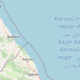
The park lies within Khachmaz Rayon in northern Azerbaijan, a region with mixed rural and agricultural character. The settlement of Yalama serves as a gateway for some tourist routes into the park, connecting visitors to the protected area. The park's establishment as a national park in 2012 reflected modern conservation planning approaches that integrate biodiversity protection with sustainable development objectives. The region has traditional land uses including hunting and fishing, with local hunting societies operating in the area and the Gülalan lake reserve managed in conjunction with these activities. The name Samur-Yalama combines references to the Samur River that flows through the broader region and the Yalama settlement, anchoring the park in local toponymy.

Top sights and standout views in Samur-Yalama National Park

Samur-Yalama protects one of Azerbaijan's significant coastal forest areas along the Caspian Sea, where chestnut oak and Persian ironwood forests represent a distinctive component of the Caspian-Hyrcanian forest ecosystem. The park's multiple landscape types support a diverse fauna including raptors like the eastern imperial eagle, large mammals like brown bear and lynx, and commercially important fish in the coastal waters. The combination of littoral, forested, and steppe habitats within a single protected area creates ecological richness that justifies the park's conservation status. The relatively recent establishment of the park in 2012 reflects contemporary conservation priorities in the South Caucasus region.

Best time to visit Samur-Yalama National Park

The park's location in Azerbaijan's northern Caspian region means visitor experiences vary considerably across seasons. The coastal forests and steppe landscapes offer different characteristics depending on rainfall patterns, with inland areas receiving higher precipitation than the coastal zone. Spring and early summer bring active wildlife activity and green vegetation, while autumn offers distinct color changes in the deciduous forests. Visitors interested in birdwatching may find the spring migration period particularly relevant for observing raptors and waterfowl. The park's eco-tourism infrastructure continues to develop following its relatively recent establishment, with the Flameland Camp Festival now held annually in May, indicating growing visitor interest in outdoor experiences at the site.

Park location guide

Geography guide, regional context, and park location map for Samur-Yalama National Park

Samur-Yalama National Park park geography, regions, and map view in Azerbaijan
Understand where Samur-Yalama National Park sits in Azerbaijan through a broader geographic reading of the surrounding landscape, nearby location context, and its mapped position within the national park landscape.

How Samur-Yalama National Park fits into Azerbaijan

Azerbaijan is a unitary semi-presidential republic and one of six independent Turkic states. It declared independence from the Soviet Union in 1991 after nearly seven decades of Soviet rule. The country occupies 86,600 km² and has a population of approximately 10.3 million. It is known for its strategic location at the crossroads of Europe and Asia, its oil industry heritage, and its diverse cultural influences from Persian, Russian, and Turkic traditions.

Wider geography shaping Samur-Yalama National Park in Azerbaijan

Azerbaijan occupies the eastern portion of the Caucasus region, situated between the Caspian Sea to the east and the Greater Caucasus mountains to the north. The terrain is diverse, featuring lowlands along the Caspian coast, mountainous areas in the north and west, and semi-desert plains in the central regions. The Kura and Aras rivers are major waterways draining into the Caspian Sea.

Map view of Samur-Yalama National Park

Use this park location map to pinpoint Samur-Yalama National Park in Azerbaijan, understand its exact geographic position, and read its mapped placement within the surrounding landscape more clearly.

Pigeon | © OpenStreetMap contributors

Location context for Samur-Yalama National Park

Khachmaz Rayon
Park atlas

Trace the geographic distribution of protected areas and compare ecological zones across the Caspian region.

Browse Related National Parks and Protected Landscapes Around Samur-Yalama National Park
After reviewing Samur-Yalama National Park, explore additional national parks and protected areas situated within the broader Caspian region and its diverse surrounding landscapes. Compare their distinct geographic settings, ecological features, and conservation mandates to gain a deeper understanding of regional protected area distribution.
National parkDagestan

Samursky National Park: National Park Protected Landscape and Geographic Atlas

Explore Dagestan's Samursky National Park mapped terrain.

Gain a structured understanding of Samursky National Park, a key national park within Russia's Dagestan region. This page focuses on its protected landscape identity, mapped boundaries, and its place within the regional geography of the North Caucasus. Use this atlas-centric view to comprehend the park's contribution to Dagestan's natural terrain and conservation landscape.

Area
483 km²
Established
2019
IUCN
II
Watercolor painting of layered mountains with green, yellow, and pink hues.
National parkAzerbaijan

Shahdag National Park: Azerbaijan's Largest National Park and Highest Mountain Landscape

Explore the Greater Caucasus protected area and its unique ecosystems.

Shahdag National Park is the largest protected area in Azerbaijan, encompassing a significant portion of the Greater Caucasus mountain range. This national park is renowned for its dramatic elevation changes, creating diverse ecosystems that transition from dense, old-growth montane forests to high-alpine meadows and rugged, rocky summits. The park's landscape is defined by its towering peaks, including Mount Bazardüzü, the nation's highest point, and provides critical habitat for endemic species like the East Caucasian tur. Use this page to begin your atlas-based exploration of Shahdag National Park's protected geography and its distinctive natural terrain.

Area
1,305.08 km²
Established
2006
Relief
Mountain
Scope
Terrestrial
National parkAzerbaijan

Altyaghach National Park: Azerbaijan's Protected Natural Area & Forested Geography

Explore the mapped boundaries and temperate deciduous forests.

Altyaghach National Park is a key protected area in Azerbaijan, safeguarding a significant portion of the Greater Caucasus's temperate deciduous broadleaved forest ecosystems. Covering over 11,000 hectares, the park is instrumental in preserving biodiversity and restoring natural habitats, notably providing refuge for the rare East Caucasian tur and other protected species. Its landscape, characterized by rolling to steep terrain and diverse forest cover reaching approximately 941 meters in elevation, makes it a representative example of Caucasus mountain conservation within the country.

Area
110.35 km²
Established
2004
Relief
Mixed relief
Climate
Temperate
Watercolor painting showing green hills, a river, and distant purple and orange mountains
National parkDedoplistsqaro Municipality

Vashlovani National Park: Georgia's Unique Lowland Desert and Badland Protected Landscape

Discover distinct semi-arid terrain and rare forest ecosystems.

Vashlovani National Park in Dedoplistsqaro Municipality represents a significant protected area preserving Georgia's rare lowland desert and semi-arid steppe ecosystems. This national park is characterized by its striking badland topography, known as the "Sharp Walls," wild pistachio forests, and riparian habitats along the Alazani River. Its unique geographic setting, far removed from Georgia's typical mountainous landscapes, makes Vashlovani a crucial site for understanding regional biodiversity and conservation within the Caucasus.

Area
442.51 km²
Established
1935
IUCN
II
Relief
Lowland
National parkAzerbaijan

Ag-Gel National Park

Azerbaijan Protected Wetland & Bird Sanctuary

Ag-Gel National Park is a protected wetland significant for migratory birds. Its landscape features a complex lake system and extensive reed beds, making it a vital conservation area in the Caspian region.

Area
179.24 km²
Established
2003
Relief
Lowland
Climate
Arid
Watercolor painting of rolling hills, a body of water, and vegetation
National parkBaku

Absheron National Park: Coastal Azerbaijan National Park with Caspian Seal Habitats

Explore mapped geography and semi-desert terrain near Baku.

Absheron National Park, located near Baku on the Absheron Peninsula, is a significant national park safeguarding coastal Caspian Sea environments. Its protected landscapes feature semi-arid terrain and are vital for the conservation of Caspian seals and migratory waterbirds. MoriAtlas provides a structured overview of this unique protected area, focusing on its geographic features, ecological importance, and its role as a key national park within Azerbaijan's atlas of natural reserves.

Area
7.83 km²
Established
2005
Relief
Lowland
Climate
Arid
National parkAzerbaijan

Göygöl National Park: Iconic Alpine Lakes and Protected Caucasus Forest Landscape

Explore Azerbaijan's most visited national park and its rich geographic context.

Göygöl National Park is a key protected area in Azerbaijan, renowned for the crystal-clear alpine Lake Göygöl and its surrounding dense forests within the Lesser Caucasus mountains. This national park showcases over 420 plant species, significant wildlife populations, and dramatic mountainous terrain, making it a prime destination for understanding regional landscape diversity and protected land value. Use MoriAtlas to explore its mapped boundaries and connect it to the broader geographic context of Azerbaijan.

Area
127.55 km²
Established
2008
Relief
Mountain
Climate
Temperate
National parkAzerbaijan

Shirvan National Park: Azerbaijan's Unique Protected Semi-Desert Ecosystem and Geography

Discover the mapped landscape, gazelle habitats, and wetland geography.

Shirvan National Park, located in Azerbaijan's Shirvan Lowland, safeguards a remarkable semi-desert environment situated on a former Caspian Sea floor. This protected area is distinguished by its low-lying terrain, ancient coastal ridges, and dune formations, providing essential habitat for the world's largest concentration of goitered gazelles. Wetlands around Çala Lake also support significant migratory bird populations, making Shirvan a crucial protected landscape for both terrestrial and avian wildlife and a key site for regional geographic study.

Area
543.735 km²
Established
2003
Relief
Lowland
Climate
Arid

Common questions about visiting, size, designation, and location context for Samur-Yalama National Park

Samur-Yalama National Park FAQs for park facts, access, geography, and protected area context
Find quick answers about Samur-Yalama National Park, including protected-area facts, park geography, trail and visitor context, and how the park fits into its surrounding country and regional landscape.
MoriAtlas Explorer

Continue Your Protected Areas Search Across the Global Atlas

Deepen your exploration by continuing the structured search for national parks and protected areas worldwide. Utilize the comprehensive filtering capabilities to compare different conservation landscapes and refine your understanding of global park geography. Discover more about the distribution and characteristics of protected natural areas.

Global natural geography