Mori Atlas logo
National parkSembilang National Park

Explore the mapped boundaries and regional geography of this significant protected natural area in Sumatra.

Sembilang National Park: Sumatra's Protected National Park Landscape and Geographic Context

Sembilang National Park represents a vital protected national park entity within the vast geographic scope of Sumatra, Indonesia. This page offers an atlas-oriented perspective, detailing the park's location and its role as a mapped natural landscape. Understanding Sembilang National Park contributes to a clearer picture of protected areas across the Indonesian archipelago and the island's unique regional geography.

Ramsar SiteMangrove ForestPeat SwampBirdwatchingMigratory BirdsWetland Conservation

Sembilang National Park

National park

Park overview

Structured park overview, official facts, and landscape profile for Sembilang National Park

Sembilang National Park park facts, protected area profile, and essential visitor context
Review the core facts for Sembilang National Park, including designation, size, terrain, visitor scale, habitats, and operating context in one park-focused overview.

About Sembilang National Park

Sembilang National Park protects one of Indonesia's most ecologically significant coastal wetland systems. The park's landscape is dominated by vast peat swamp forests and mangrove ecosystems that have developed in the low-lying coastal zone of eastern Sumatra. These peat deposits, some of the deepest in Southeast Asia, store significant quantities of carbon and play a crucial role in regional hydrology. The park's position along the East Asian Australasian Flyway makes it a critical node in the network of migratory bird habitats that spans from Russia and Japan to Australia. The rivers and channels that traverse the park support rich aquatic communities, while the forest interior provides refuge for some of the region's most endangered large mammals. Access to the park requires travel by road from Palembang followed by boat transport through the intricate waterway network that characterizes this coastal landscape. The park's management works to balance conservation objectives with the needs of surrounding communities who traditionally depend on the estuary's resources.

Quick facts and research context for Sembilang National Park

Sembilang National Park is located on the eastern coast of Sumatra in Indonesia, approximately a two-and-a-half-hour journey from Palembang involving both overland and water transport. The park covers 2,051 square kilometers and is characterized by extensive peat swamp and mangrove environments. It supports 53 mammal species, over 140 fish species, and hosts what is considered the world's most complex shorebird community with 213 recorded species. The park contains the largest breeding colony of milky storks globally and serves as a critical stopover site for up to 100,000 migratory birds during winter months.

Park context

Deeper park guide and search-rich context for Sembilang National Park

Sembilang National Park history, landscape, wildlife, and travel context
Explore Sembilang National Park through its history, landscape character, ecosystems, wildlife, conservation priorities, cultural context, and seasonal travel timing in a structured park guide built for atlas discovery and search intent.

Why Sembilang National Park stands out

Sembilang National Park is best known for hosting the world's largest breeding colony of milky storks, a striking white wading bird classified as endangered. The park also supports the most complex shorebird community on the planet, with 213 species documented within its boundaries. Its extensive mangrove and peat swamp forests provide critical habitat for threatened species including the Sumatran tiger, Sumatran elephant, and both Irrawaddy dolphins and finless porpoises in its river systems. The wetland complex represents one of the last intact coastal swamp ecosystems in Sumatra and serves as a vital ecological corridor alongside Berbak National Park.

Sembilang National Park history and protected-area timeline

Sembilang National Park was officially established in 2001 and formally declared in 2003 under Indonesia's Ministry of Forestry. The protected area was created to preserve the outstanding biodiversity values of Sumatra's eastern coastal swamp ecosystems, which had faced increasing pressure from logging, agricultural expansion, and coastal development. The park's recognition as a Ramsar Wetland of International Importance followed in 2011, acknowledging its global significance as a waterbird habitat. In 2018, Sembilang National Park was incorporated into the UNESCO World Network of Biosphere Reserves together with the neighboring Berbak National Park in Jambi Province, recognizing the combined area's exceptional ecological importance and its potential as a model for sustainable development. Climate change has emerged as a significant challenge, with Betet Island within the park reportedly becoming submerged beneath one meter of seawater as of 2020, representing the loss of a former Sumatran tiger habitat.

Sembilang National Park landscape and geographic character

The physical landscape of Sembilang National Park is defined by its position at the interface between terrestrial and marine environments along Sumatra's east coast. The park encompasses extensive flat coastal terrain with elevations rarely exceeding a few meters above sea level. Its ecosystems range from dense mangrove forests along the tidal waterways to interior peat swamp forests where organic matter has accumulated over millennia. Freshwater swamp forests occupy the transitional zones further inland, while mud flats and riparian corridors line the major river channels that drain into the Strait of Malacca. The park's hydrological complexity includes a network of meandering rivers, seasonal flooded areas, and permanent water bodies that create a dynamic landscape constantly shaped by tidal cycles and monsoon rainfall patterns. The peat soils, which can reach significant depths, support a distinctive vegetation adapted to waterlogged conditions and acidic substrates.

Sembilang National Park ecosystems, habitats, and plant life

Sembilang National Park represents a center of ecological diversity within Southeast Asia's tropical wetland zone. Approximately half of the park's area is covered by mangrove forests that form a vital coastal protection zone and serve as nurseries for marine and freshwater fish species. The remaining landscape includes peat swamp forests, lowland tropical forests, and freshwater swamp ecosystems that together create a heterogeneous habitat matrix supporting remarkable biodiversity. The park's status as a Ramsar site reflects its international importance as a waterbird habitat, with the wetland complex supporting species that depend on healthy coastal ecosystems throughout their migratory cycles. The peat swamp forests store significant carbon stocks and play essential roles in water regulation and flood mitigation for the surrounding region. These ecosystems also provide critical ecosystem services including timber, non-timber forest products, and fish resources that support local communities.

Sembilang National Park wildlife and species highlights

The wildlife community of Sembilang National Park includes 53 documented mammal species, with the park providing habitat for several critically endangered and vulnerable species. The Sumatran tiger, one of the rarest big cat subspecies, and the Sumatran elephant both occur within the park's forested interior. The Malayan tapir, the largest of Asia's four tapir species, inhabits the forested zones alongside primates including the agile gibbon and siamang. The park's predator community includes the Sunda clouded leopard and marbled cat, while the sun bear represents the smallest bear species found in the park. The aquatic environments support a remarkable diversity, with over 140 fish species and 38 crab species recorded from the park's rivers and waterways. The mammal fauna also includes the flat-headed cat, one of the rarest and least known felines, and the southern pig-tailed macaque. River dwellers include the endangered smooth-coated otter and Eurasian otter, as well as several turtle species and marine mammals including the Irrawaddy dolphin and finless porpoise. The bird community is exceptional, with the largest breeding colony of milky storks in the world and one of the largest colonies of lesser adjutant found within the park. Threatened bird species include Storm's stork, white-winged duck, Nordmann's greenshank, and the Far Eastern curlew. The total bird population has been estimated at up to one million individuals, with winter populations swollen by up to 100,000 migratory birds stopping to rest.

Sembilang National Park conservation status and protection priorities

Sembilang National Park faces several significant conservation challenges despite its protected status. Illegal logging, both legal and illicit extraction of timber from the peat swamp and mangrove forests, remains a persistent threat to the park's ecological integrity. Coastal erosion, measured at approximately 15 meters per year in some areas, progressively reduces the park's coastal boundaries and destroys mangrove habitat. The expansion of coastal fish ponds has also encroached on natural ecosystems and altered the hydrology of coastal areas. Climate change presents an emerging threat that has already resulted in the loss of Betet Island, a former island within the park that is now submerged below sea level. Conservation responses have included mangrove restoration efforts covering approximately 200 hectares, with ongoing programs to expand these initiatives. The park's inclusion in the UNESCO World Network of Biosphere Reserves in 2018 provides an additional framework for sustainable management and international cooperation in conservation. The designation as a Ramsar site since 2011 also commits Indonesia to maintaining the wetland's ecological character and promoting wise use of its resources.

Sembilang National Park cultural meaning and human context

Sembilang National Park exists within a landscape shaped by the interaction between human communities and the coastal wetland environment. The surrounding region includes communities whose traditional livelihoods depend on fishing, collecting forest products, and utilizing the estuary's resources. These communities maintain cultural connections to the wetland landscape that predate the establishment of formal protected area status. Access to the park requires traversing through community lands and waterways that have been used for generations. The park's management involves coordination with local stakeholders to ensure that conservation objectives can be balanced with sustainable use of natural resources by neighboring communities.

Top sights and standout views in Sembilang National Park

Sembilang National Park stands as one of Southeast Asia's most important coastal wetland protected areas, combining exceptional biodiversity with critical ecosystem services. The park's shorebird community of 213 species represents the most complex in the world, while the largest breeding colony of milky storks provides a unique wildlife spectacle. The combination of mangrove forests, peat swamps, and freshwater wetlands creates a diverse habitat matrix supporting both large mammals and marine species including dolphins. The park's Ramsar designation and UNESCO Biosphere Reserve status reflect its international significance, while its proximity to Palembang makes it relatively accessible for visitors willing to undertake the required water transport. Climate-related changes affecting the park, including island loss to sea level rise, underscore the vulnerability of low-lying coastal ecosystems and the importance of conservation intervention.

Best time to visit Sembilang National Park

The optimal time to visit Sembilang National Park corresponds to the dry season when water levels are lower and wildlife viewing opportunities are enhanced. The period between March and October generally offers more stable conditions for navigating the park's extensive waterways and accessing interior areas. Birdwatching is particularly productive during the winter months from approximately November to March when migratory species from the northern hemisphere join the resident population, with peak numbers of up to 100,000 migratory birds present during this period. The wet season brings higher water levels that may restrict access to some interior areas but also reveals the wetland ecosystem's flood dynamics. Visitors should be prepared for the humidity and insect populations typical of tropical wetland environments year-round.

Park location guide

Geography guide, regional context, and park location map for Sembilang National Park

Sembilang National Park park geography, regions, and map view in Indonesia
Understand where Sembilang National Park sits in Indonesia through a broader geographic reading of the surrounding landscape, nearby location context, and its mapped position within the national park landscape.

How Sembilang National Park fits into Indonesia

Indonesia is a vast archipelagic nation in Southeast Asia and Oceania, spanning over 17,000 islands between the Indian and Pacific Oceans. As the world's fourth-most populous country with 288 million people, it features extraordinary cultural and biological diversity, withJavanese and Sundanese being the largest ethnic groups. The country gained independence from the Netherlands in 1945 and operates as a unitary presidential republic.

Wider geography shaping Sembilang National Park in Indonesia

Indonesia is situated in Southeast Asia and Oceania, spanning the equatorial region between the Indian Ocean to the west and the Pacific Ocean to the east. The archipelago includes major islands such as Sumatra, Java, Sulawesi, and parts of Borneo and New Guinea. It borders Papua New Guinea, Timor-Leste, and Malaysia by land, with extensive maritime boundaries throughout the region.

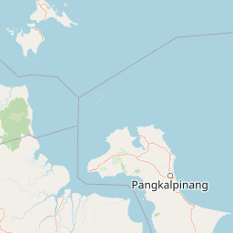
Map view of Sembilang National Park

Use this park location map to pinpoint Sembilang National Park in Indonesia, understand its exact geographic position, and read its mapped placement within the surrounding landscape more clearly.

Pigeon | © OpenStreetMap contributors

Location context for Sembilang National Park

Sumatra
Park atlas

Compare protected wetland landscapes and coastal ecosystems, tracing the regional geography of parks near Sembilang National Park in Sumatra.

Explore Other National Parks and Protected Areas Near Sembilang National Park
Continue your exploration from Sembilang National Park by browsing other national parks and protected areas located throughout the vast wetland and coastal regions of Sumatra, Indonesia. This comparative overview allows you to map diverse protected landscapes, understand their regional context, and trace the spread of critical conservation areas across the island.
National parkJambi

Berbak National Park National Park: Discover Protected Landscape Geography in Jambi

Explore mapped boundaries and regional context for this Sumatran protected area.

Berbak National Park is an officially designated national park within Indonesia's Jambi province. This page provides detailed geographic context, focusing on the park's mapped boundaries and its role as a protected landscape. Users can explore its placement within the broader regional geography of Sumatra, understanding how it contributes to the conservation landscape of the Jambi area for atlas-based discovery.

Area
1,627 km²
Established
1992
IUCN
II
Relief
Lowland
National parkJambi

Bukit Duabelas National Park: Jambi's Protected Lowland Tropical Rainforest Landscape

Explore its mapped terrain and vital water catchment geography.

Bukit Duabelas National Park is a protected area in Jambi, Sumatra, safeguarding critical lowland tropical rainforest ecosystems. Its name reflects the hilly terrain that defines its landscape, acting as an essential water catchment for the Batang Hari River. This park offers an atlas-focused view of Sumatra's threatened forest heritage and its importance within regional geography, including unique timber species and the ancestral lands of the Orang Rimba people.

Area
605 km²
Established
2000
IUCN
II
Relief
Lowland
National parkIndonesia

Bukit Tigapuluh National Park: Protected Area Identity and Indonesian Geographic Context

Explore mapped boundaries and regional landscape features.

Bukit Tigapuluh National Park stands as a protected natural area within Indonesia. This entry provides detailed geographic information, focusing on its mapped extent and its contribution to the nation's conservation atlas. Understanding its place within Indonesia's broader geography highlights the significance of its protected landscape and its role in regional natural resource mapping.

Area
1,432.23 km²
Established
1995
IUCN
II
Relief
Lowland
National parkWest Sumatra

Kerinci Seblat National Park: National Park Protected Landscape in West Sumatra

Explore its mapped geography and regional atlas context.

Kerinci Seblat National Park represents a critical protected area, identified as a national park within Indonesia's West Sumatra province. This page provides a deep dive into its geographic footprint and landscape characteristics, serving as a key entry point for understanding the park's specific context. Users can leverage this detailed information for map-based exploration and to grasp its significance within the larger atlas of protected natural lands, focusing on its distinct geographical identity.

Area
13,750 km²
Established
1999
IUCN
II
Relief
Mountain
National parkLampung

Way Kambas National Park: Mapped Lowland Rainforest and Wetland Ecosystems

Explore the geography and protected landscape of this Indonesian national park.

Way Kambas National Park in Lampung, Indonesia, is a significant protected area characterized by its extensive lowland rainforest and varied wetland habitats. The park's landscape features swamp forests, coastal fringes, and river systems, creating a unique ecological mosaic. It serves as a critical sanctuary for endangered species, offering a vital context for understanding Sumatra's remaining natural landscapes. Explore the mapped boundaries and geographic identity of this important conservation area.

Area
1,300 km²
Established
1989
IUCN
II
Visitors
2.6K annual
National parkSumatra

Bukit Barisan Selatan National Park: Sumatra's Critical Tropical Rainforest Corridor

Explore mapped boundaries and regional geography within this protected area.

Bukit Barisan Selatan National Park is a substantial national park located in Sumatra, Indonesia, designated as a protected landscape along the southern Bukit Barisan mountain range. Spanning a considerable area, it functions as a crucial corridor of tropical rainforest, playing a pivotal role in conservation efforts and the preservation of Sumatra's unique geographic identity. This page serves as a dedicated entry point for understanding the park's protected area status and its mapped presence within the broader regional geography of Indonesia.

Area
3,568 km²
Established
1982
IUCN
II
Relief
Mountain
National parkRiau Province

Tesso Nilo National Park: Exploring Its Protected Landscape and Geographic Identity in Riau Province

Mapped boundaries and regional park atlas context.

Uncover the core identity of Tesso Nilo National Park, a designated national park situated within Riau Province. This entry focuses on its role as a protected landscape, detailing its mapped geographic footprint and offering insights relevant for atlas exploration. Understand how its protected area status contributes to the regional geography and landscape context of Indonesia, providing a focused view for geographic discovery.

Area
1,000 km²
Established
2004
IUCN
II
Relief
Lowland
National parkBanten

Ujung Kulon National Park: Atlas of Java's Last Lowland Rainforest and Protected Landscapes

Explore the unique geography and critical conservation importance of this vital protected area.

Ujung Kulon National Park, located in Banten, Indonesia, is a crucial protected landscape recognized for its ecological significance. This national park represents the last substantial area of lowland rainforest remaining on Java, making it an indispensable sanctuary. It is globally recognized as the primary and final refuge for the Javan rhinoceros, a critically endangered species. The park's geography encompasses the Ujung Kulon peninsula and mountain ranges, alongside vital marine environments, contributing to its status as a UNESCO World Heritage Site and a cornerstone of regional conservation efforts.

Area
497.59 km²
Established
1992
IUCN
II
Visitors
12K annual

Common questions about visiting, size, designation, and location context for Sembilang National Park

Sembilang National Park FAQs for park facts, access, geography, and protected area context
Find quick answers about Sembilang National Park, including protected-area facts, park geography, trail and visitor context, and how the park fits into its surrounding country and regional landscape.
MoriAtlas Explorer

Continue Your Protected Areas Search Across the Global Atlas

Deepen your exploration by continuing the structured search for national parks and protected areas worldwide. Utilize the comprehensive filtering capabilities to compare different conservation landscapes and refine your understanding of global park geography. Discover more about the distribution and characteristics of protected natural areas.

Global natural geography