
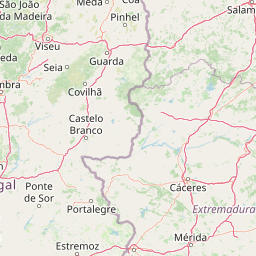
Viewpoints
Park geography
Mapping the natural features, elevation extremes, and protected boundaries of this Portuguese reserve
Comprehensive Geographic Profile and Mapped Terrain of Serra da Estrela Natural Park
This geographic profile details the physical landscape of Serra da Estrela Natural Park across its 891.32 square kilometer boundary in Portugal. Explore structured data on the high mountain terrain, elevation range spanning 291 to 1993 meters, and a wide array of documented springs, peaks, and viewpoints located across the reserve.
Portugal's highest mountain range protecting glacial valleys, endemic flora, and traditional pastoral landscapes
Serra da Estrela Natural Park
Serra da Estrela Natural Park is the largest natural conservation area in Portugal, encompassing the country's highest mountain range in the Central Region. The park occupies roughly 891 square kilometers of the Serra da Estrela, a granite and schist massif that rises dramatically from the surrounding Beira interior landscape to the highest peak in Continental Portugal at Torre, reaching nearly 2,000 meters above sea level. The park is the source of three major Portuguese rivers: the Mondego, the Zêzere (a tributary of the Tagus), and the Alva, all originating from glacial valleys and high-altitude springs that have shaped the region's hydrology for millennia. Designated as an IUCN Category V protected landscape in 1976, the park preserves a remarkable combination of alpine habitats, endemic species, glacial landforms from the Quaternary period, and centuries of traditional pastoral land use that defines the cultural identity of the mountain communities.
- Location
- Portugal
- Park type
- Nature reserve
- Established
- 1976
- Area
- 891.3 km²
- Highest point
- 1,993 m
Location overview
Mapping the country membership and geographic status within Portugal
Serra da Estrela Natural Park Geographic Location in Portugal
Serra da Estrela Natural Park is situated entirely within the national borders of Portugal. The inland protected area features a single country jurisdiction with no transboundary or marine classification.
- Countries
- Portugal
- Primary location
- Portugal
- Geographic setting
- Inland
Boundary and coordinates
Interactive boundary geometry and recorded spatial measurements
Serra da Estrela Natural Park Boundary Map and Geographic Extent
Mapped park outlines provide essential spatial context for analyzing protected boundaries across the terrain. Accompanying facts detail total area measurements, coordinate limits, geographic spans, and regional center points.
- Boundary area
- 891.3 km²
- Boundary perimeter
- 215.1 km
- Northernmost point
- 40.6355° N
- Southernmost point
- 40.2329° N
- Easternmost point
- 7.2896° W
- Westernmost point
- 7.8075° W
- Geographic centre
- 40.4184° N, 7.5351° W
- North–south span
- 44.7 km
- East–west span
- 43.9 km
Elevation and terrain
Explore recorded vertical ranges and mapped natural feature records.
Serra da Estrela Natural Park Elevation and Mountain Terrain Geography
Elevation summary records document vertical relief spanning from 291 meters to 1993 meters across the mountain terrain. Linked feature cards supply names, types, and spatial relationships for interior streams, peaks, and reservoirs.
- Minimum elevation
- 291 m
- Maximum elevation
- 1,991 m
- Highest point
- 1,993 m
Selected named natural features
Streams
Ribeira de Tapadinha
Streams
Ribeiro de Sarzedo
Streams
Ribeiro de Salgueirais
Beaches
Praia Fluvial da Relva da Reboleira
Streams
Ribeira do Colmeal
Environmental setting
Temperate climate, mountain relief, and forest cover classifications
Serra da Estrela Natural Park Environmental Classifications and Physical Setting
Recorded landscape features, habitat types, and seasonal classifications provide complementary interpretations of the physical setting across Serra da Estrela Natural Park. Associated categories link directly to relevant atlas destinations to support structured environmental exploration.
- Relief
- Mountain
- Climate
- Temperate
- Water
- Minor water
- Forest cover
- Mostly forested
- Seasonality
- Seasonal
Landscape features
Mountains · Valleys · Plateau · Lakes · Rivers · Grassland · Wetland
Habitat types
Temperate broadleaf forest · Montane forest · Alpine meadow · Grassland · Wetland · Riverine habitat
Park atlas
Trace the regional spread of protected areas; compare unique mountain, glacial, and pastoral landscapes surrounding Serra da Estrela Natural Park.
Continue Your Park Discovery: Explore National Parks Near Serra da Estrela Natural Park
Explore other national parks and protected areas near Serra da Estrela Natural Park, discovering a wider array of mountain ranges, glacial formations, and traditional pastoral landscapes. This geographic comparison provides valuable context for understanding regional conservation efforts and the varied protected-area geography beyond a single park.
Protected landscapePortalegre District
73 km away#1 closest
South

Serra de São Mamede Natural Park: A Protected Landscape Defined by Ecological Transition
Explore the unique mountain terrain and ecosystems of Portalegre District.
Delve into the geographic and ecological identity of Serra de São Mamede Natural Park, a significant protected landscape situated in Portugal's Portalegre District. This area is renowned for its dramatic quartzite ridges and its role as a crucial meeting point for Atlantic and Mediterranean plant communities, offering a unique atlas perspective on regional biodiversity. Examining its mapped boundaries and diverse terrain provides essential context for understanding its ecological importance and its distinct position within the Alentejo region's geography.
- Area
- 560.6 km²
- Established
- 1989
- IUCN
- V
- Visitors
- 4.5K annual
Protected areaPortugal
85 km away#2 closest
North
Alvão Natural Park Protected Area: Atlas Exploration of Northern Portugal's Mountain Geography
Discover dramatic landscapes and mapped terrain.
Alvão Natural Park is a protected area in northern Portugal distinguished by its stark geological contrasts: upper granite plateaus and steep schist lowlands. This unique geography supports diverse ecosystems and features the impressive Fisgas de Ermelo waterfall. Explore the park's mapped boundaries and its role as a significant protected landscape within the region, offering rich context for any geographic exploration.
- Area
- 72.03 km²
- Established
- 1983
- IUCN
- V
- Visitors
- 29.6K annual
Protected landscapePortugal
103 km away#3 closest
Southwest
Aire and Candeeiros Ranges Natural Park: Protected Landscape and Regional Geographic Context
Explore the mapped boundaries and natural landscape of this Portuguese protected area.
Understand the Aire and Candeeiros Ranges Natural Park as a key protected landscape in Portugal. This page offers detailed geographic information, focusing on the park's mapped boundaries and its intrinsic connection to the surrounding regional geography. It serves as a portal for atlas exploration, providing structured data for users interested in the specific protected area and its landscape characteristics within the Iberian Peninsula.
- Area
- 383.93 km²
- Established
- 1979
- IUCN
- V
- Visitors
- 31.9K annual
National parkExtremadura
124 km away#4 closest
Southeast

Monfragüe National Park: Dramatic Cliffs, Raptor Haven, and Extremadura's Protected Landscape
Discover its mapped terrain and unique geography in Spain.
Monfragüe National Park, situated in Extremadura, Spain, offers a compelling study in protected landscape geography. The park's identity is shaped by its formidable cliffs and river valleys carved by the Tagus, providing critical nesting grounds for European raptors. This MoriAtlas entry details the park's mapped boundaries and its significance as a vital protected area within the region. Users can explore the specific natural terrain and regional context that establish Monfragüe as a unique protected territory.
- Area
- 179 km²
- Established
- 2007
- IUCN
- II
- Visitors
- 331.8K annual
National parkPortugal
130 km away#5 closest
North
Peneda-Gerês National Park: A Distinct Protected Landscape in Northern Portugal
Granite peaks, glacial valleys, and cultural heritage mapped.
Peneda-Gerês National Park represents a cornerstone of protected landscapes in Portugal, celebrated for its rugged granite mountains and deep glacial valleys sculpted over millennia. This national park showcases a rare ecological transition zone with unique endemic species and features dramatic waterfalls and pristine river systems. The park's rich cultural tapestry, interwoven with its natural environment, offers a compelling subject for atlas-based geographic discovery and landscape exploration.
- Area
- 695.93 km²
- Established
- 1971
- IUCN
- II
- Visitors
- 92.8K annual
National parkSpain
About 131 km away#6 closest
Southeast
Monfragüe National Park: Protected Landscape Atlas of Spanish Raptor Colonies
Explore mapped terrain and regional geography within this Spanish National Park.
As a national park in Spain's Extremadura region, Monfragüe National Park offers a distinct protected landscape shaped by the Tagus River and dramatic limestone cliffs. It is globally recognized for its exceptional birdlife, especially its large griffon vulture colonies and populations of Spanish imperial eagles, making it a significant site for ecological study and atlas-based exploration of protected areas. The park's landscape, characterized by Mediterranean woodlands and rugged terrain, provides crucial habitat and a unique geographic context for understanding Iberian Peninsula conservation.
- IUCN
- II
- Scope
- Terrestrial

Protected landscapeBragança District
135 km away#7 closest
North
Montesinho Natural Park: Protected Landscape in Bragança District, Portugal
Explore mapped boundaries and regional landscape context.
Montesinho Natural Park is designated as a protected landscape in northeastern Portugal, located within the administrative region of Bragança District. This page serves as an entry point to understanding the park's protected area characteristics, its mapped geographic footprint, and its role in the broader natural landscape of the Trás-os-Montes region. Discover the atlas value of this significant protected territory and its relation to surrounding geography.
- Area
- 742.25 km²
- Established
- 1979
- IUCN
- V
- Relief
- Mountain

Protected landscapeEsposende
145 km away#8 closest
Northwest
Northern Littoral Natural Park Protected Landscape: Geographic Discovery and Atlas Context
Mapped protected areas and regional landscape discovery near Esposende.
Uncover the geographic identity of Northern Littoral Natural Park, a key protected landscape situated near Esposende. This MoriAtlas entry focuses on its mapped boundaries and regional significance, providing a factual basis for understanding its role within Portugal's network of protected areas. Explore the park's natural terrain and its context within the broader geography of the Norte region for comprehensive atlas-based discovery.
- Area
- 87.62 km²
- Established
- 1987
- IUCN
- V
- Relief
- Lowland
MoriAtlas Explorer
Continue Exploring Serra da Estrela Natural Park's Geographic Context
Delve deeper into the protected landscape of Serra da Estrela Natural Park, understanding its place within Portugal's regional geography and its unique glacial terrain. Use our platform to trace the park's mapped boundaries and explore its surrounding natural context, expanding your atlas discovery of this significant Iberian mountain range.
Browse next
Global natural geography
Explore related park routes
Explore MoriAtlas Global ParksBrowse All MoriAtlas ParksGlobal Park Map DiscoveryMoriAtlas: Browse All CountriesBrowse All MoriAtlas ContinentsNational Park Environment AtlasGrand Canyon National Park AtlasYellowstone National Park AtlasYosemite National Park Atlas and GeographySerengeti National Park AtlasGalápagos National Park Protected LandscapeBanff National Park Geography and AtlasKruger National Park Atlas EntryUluṟu-Kata Tjuṯa National Park AtlasExplore Uluru-Kata Tjuta National Park GeographyPlitvice Lakes National Park AtlasFiordland National Park Protected LandscapeGreat Smoky Mountains National Park AtlasAfghanistan National Parks and Protected AreasAlbania National Parks and Protected AreasAlgeria National Parks and Protected AreasAmerican Samoa National Parks and Protected AreasAndorra National Parks and Protected AreasAngola National Parks and Protected AreasAntarctica National Parks and Protected AreasAntigua and Barbuda Park List