Peaks
Craig-y-garn
363 m

A technical profile of terrain elevation, landscape features, and boundary measurements
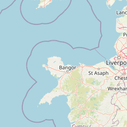
This geographic dataset provides a structured look at the physical composition of Snowdonia National Park. Covering an area of 2142 square kilometers, the park contains diverse mountain terrain, riverine systems, and temperate habitats. Explore mapped coordinates, peak elevation points reaching 1085 meters, and various cliffs and water features within the protected boundary.

Wilderness mountains and lakes of north Wales
Snowdonia National Park covers the mountainous region of north Wales, protecting a landscape of rugged peaks, steep valleys, glacial lakes, and open moorland. The park encompasses Snowdon, the highest mountain in Wales and England, alongside a collection of other notable summits and the lakes that dot its valleys. Established in 1951, it was the first national park in Wales and remains one of the most recognisable protected landscapes in the United Kingdom. The area is renowned for its ecological diversity, from montane heath and cliff communities to oak woodlands and bog habitats.
Regional boundary mapping and national terrestrial status in Wales
Interactive boundary geometry and spatial dimensions
Mountain relief statistics and internal geographical formations
Peaks
363 m
Peaks
553 m
Peaks
397 m
Peaks
389 m
Peaks
710 m
Peaks
367 m
Temperate mountain relief, major water bodies, and diverse woodland habitats
Mountains · Valleys · Lakes · Rivers · Forest · Woodland · Cliffs
Temperate broadleaf forest · Temperate coniferous forest · Montane forest · Grassland · Riverine habitat · Wetland
Compare park geography, upland landscapes, and conservation regions adjacent to Snowdonia.
South

Discover the estuarine wetlands, raised mires, and Atlantic woodlands of a key Welsh biosphere reserve
The Dyfi Biosphere provides a comprehensive look at the geography of a protected coastal region in Wales. Its boundaries encompass diverse terrain ranging from the Ynyslas sand spit and salt marshes to the primary raised mire of Cors Fochno. This landscape functions as a vital wetland system, offering a clear visual representation of dune succession, peatland growth, and temperate Atlantic woodland ecosystems within a single, interconnected, and carefully monitored geographic area.
South
Discover mapped terrain, park boundaries, and regional geography.
Brecon Beacons National Park, officially Bannau Brycheiniog, stands as a premier protected area within Wales, covering over 1,344 square kilometers of striking mountainous terrain. This national park is defined by its dramatic Old Red Sandstone ranges, including Pen y Fan, South Wales' highest peak, and features diverse landscapes from heather moorland to extensive river valleys. Its mapped boundaries encompass unique geological features, significant historical sites, and provide context for regional geographic exploration, making it a key destination for understanding protected lands in the UK.
Southwest
Explore unique seaside terrain and regional geography.
Delve into the Pembrokeshire Coast National Park, a premier protected landscape recognized for its extraordinary coastal formations and diverse natural terrain. This atlas entry details the park's distinct mapped boundaries, from its iconic limestone cliffs and sea stacks to its sheltered estuaries and inland Preseli Hills. Understand how this significant national park contributes to the protected area map of Pembrokeshire and offers unparalleled opportunities for geographic discovery along the Welsh coast.
North
Mapped protected landscape in northwest England
West of Walney is a major marine protected area off the Cumbrian coast, notable for its 388 square kilometre coverage of subtidal mud and sand habitats. This site is uniquely shaped by its overlap with offshore wind energy infrastructure, providing a distinct study in regional conservation and seabed management within the Irish Sea.
Northeast
Mapped boundaries and natural terrain context for this UK national park.
Investigate the Peak District National Park, a cornerstone of the United Kingdom's protected natural areas. This MoriAtlas entry provides essential details on its geographic scope, mapped boundaries, and landscape characteristics. Engage with structured data to understand how this national park fits into the atlas of the United Kingdom, supporting detailed geographic and protected-area discovery for researchers and explorers.
North
Mapped mountain terrain and glacial valleys in Cumbria
Delve into the geography of Lake District National Park, a protected area renowned for its dramatic mountainous terrain, U-shaped glacial valleys, and stunning natural lakes. This atlas perspective highlights the park's unique landscape features, mapped boundaries, and its significance within Cumbria, offering a comprehensive view for geographic discovery.
Northeast
Lancashire coastal wetland and reedbed ecosystems
Leighton Moss RSPB Reserve stands as the largest reedbed complex in north west England. This protected wildlife reserve offers a distinct landscape contrast between enclosed freshwater wetlands and the open saltmarsh of Morecambe Bay, providing essential habitat data for regional environmental study and birdlife geography.

West

Explore County Wicklow's mapped natural terrain and park boundaries.
Understand the geographic scope and protected landscape identity of Wicklow Mountains National Park. This page offers detailed information on its mapped boundaries and its context within County Wicklow, providing a foundation for atlas-based discovery of Ireland's natural areas. Explore how this national park contributes to the region's mapped geography and conservation landscapes.
Delve deeper into the geographic context and mapped terrain of Snowdonia National Park. Understanding this iconic Welsh protected landscape provides a foundation for exploring its regional setting and the broader atlas of protected areas within the United Kingdom. Discover the patterns of protected lands and the unique geographic features that define this significant mountain region.