Mori Atlas logo
National parkSri Venkateswara National Park

Explore the mapped boundaries and regional natural terrain of this significant protected area.

Sri Venkateswara National Park: Andhra Pradesh National Park Atlas and Protected Landscape Geography

Sri Venkateswara National Park represents a key protected landscape within Andhra Pradesh, India. This page offers an atlas-driven exploration of its national park status, providing detailed insights into its geographic setting and the mapped extent of its protected natural terrain. Understand the park's specific identity and its place within the regional geography, focusing on structured discovery of its landscape context and mapped boundaries.

Eastern GhatsDeciduous ForestsBirdwatchingEndemic SpeciesWaterfallsBiosphere Reserve

Sri Venkateswara National Park

National park

Park overview

Structured park overview, official facts, and landscape profile for Sri Venkateswara National Park

Sri Venkateswara National Park park facts, protected area profile, and essential visitor context
Review the core facts for Sri Venkateswara National Park, including designation, size, terrain, visitor scale, habitats, and operating context in one park-focused overview.

About Sri Venkateswara National Park

Sri Venkateswara National Park represents one of Andhra Pradesh's most important ecological treasures, protecting a substantial portion of the Eastern Ghats' Seshachalam Hills range in Tirupati district. The park's establishment in 1989 marked a significant milestone in India's conservation efforts, providing formal protection to forests that had long been threatened by human activity and development pressures. The landscape features characteristic undulating terrain with forest-covered valleys that create diverse microhabitats supporting both dry and moist deciduous vegetation types. Beyond its ecological significance, the park holds deep cultural importance as it encompasses the sacred Tirumala hills, a major pilgrimage destination for millions of devotees visiting the Venkateswara Temple. This intersection of religious significance and biodiversity conservation creates unique management challenges and opportunities. The park's inclusion as the core zone of the Seshachalam Biosphere Reserve in 2010 elevated its conservation status and integrated it into broader regional planning frameworks. Threats from infrastructure development, including highway construction and dam projects, along with periodic forest fires, continue to require active management intervention to preserve this remarkable ecosystem.

Quick facts and research context for Sri Venkateswara National Park

Located in the Eastern Ghats within Tirupati district of Andhra Pradesh, Sri Venkateswara National Park covers 353 square kilometers of mountainous terrain. The park was established in September 1989 and holds IUCN Category II protection status. It forms part of the Seshachalam Hills biosphere reserve, declared in 2010. The elevation ranges from 150 to 1,130 meters, with vegetation combining dry deciduous and moist deciduous forest types. Annual rainfall averages 900 millimeters and temperatures range from 12 to 44 degrees Celsius. The park contains approximately 1,500 vascular plant species across 174 families, with many endemic species, and supports about 178 bird species along with diverse mammalian and reptile populations.

Park context

Deeper park guide and search-rich context for Sri Venkateswara National Park

Sri Venkateswara National Park history, landscape, wildlife, and travel context
Explore Sri Venkateswara National Park through its history, landscape character, ecosystems, wildlife, conservation priorities, cultural context, and seasonal travel timing in a structured park guide built for atlas discovery and search intent.

Why Sri Venkateswara National Park stands out

Sri Venkateswara National Park is best known for its extraordinary botanical wealth, particularly the presence of red sanders (Pterocarpus santalinus), a highly valuable and endemic tree species. The park also features prominent waterfalls including Talakona, one of the region's most spectacular cascades. The return of Asian elephants to this area in 1984 after a 300-year absence represents a remarkable conservation success story. The park's avifauna is exceptional, supporting the globally threatened yellow-throated bulbul and the critically endangered Oriental white-backed vulture. The presence of the Indian golden gecko, rediscovered in the Eastern Ghats ravines of this park in 1985, adds to its scientific significance.

Sri Venkateswara National Park history and protected-area timeline

The formal establishment of Sri Venkateswara National Park in September 1989 created a protected framework for the Seshachalam Hills, which had long served as a sacred landscape under the stewardship of the Tirumala Tirupati Devasthanam. Prior to national park status, the area functioned as the Tirumala Wildlife Sanctuary, providing baseline protection for the region's wildlife and forests. The 2010 declaration of the Seshachalam Hills as one of India's biosphere reserves represented a significant expansion of the conservation framework, integrating the national park into a larger biosphere reserve that coordinates protection across multiple land uses. A notable milestone in the park's ecological history came in 1984, when Asian elephants returned to the region after being absent from Andhra Pradesh for nearly 300 years. A breakaway herd of five individuals subsequently moved into the Chamala Valley of Tirumala forests within the national park in 1993, marking the species' gradual recolonization of its historic range. This elephant return represents one of India's most significant wildlife recovery narratives.

Sri Venkateswara National Park landscape and geographic character

The physical landscape of Sri Venkateswara National Park is defined by its position within the Eastern Ghats, a complex mountain system that runs parallel to India's eastern coast. The Seshachalam Hills form the core of the park's terrain, characterized by undulating ridges and valleys that create a visually dramatic topography. Elevations within the park range from 150 meters in the lower reaches to 1,130 meters at the higher points, establishing distinct ecological zones across this altitudinal gradient. The forest-covered valleys retain moisture and support more luxuriant vegetation, creating sharp contrasts with the drier hill slopes. Several significant waterfalls punctuate the landscape, with Talakona being the most prominent, along with Gundalakona and Gunjana. The region experiences a bimodal monsoon pattern, receiving most precipitation from the northeast monsoon with a smaller contribution from the southwest monsoon, totaling approximately 900 millimeters annually. Temperature extremes span from 12 to 44 degrees Celsius, creating seasonal variations that influence vegetation dynamics and wildlife behavior.

Sri Venkateswara National Park ecosystems, habitats, and plant life

The ecological character of Sri Venkateswara National Park centers on its remarkable botanical diversity, with approximately 1,500 vascular plant species documented across 174 families. This extraordinary floristic wealth includes numerous endemic species that occur nowhere else on Earth, making the park a global conservation priority. The vegetation is predominantly dry deciduous forest, transitioning to moist deciduous types in the valley bottoms where moisture accumulates. Among the most significant plant species is red sanders (Pterocarpus santalinus), a leguminous tree prized for its rich red timber and endemic to this region. Other notable endemics include Shorea talura, Shorea tumbugaia, Terminalia pallida, sandalwood (Santalum album), Cycas beddomei, Syzygium alternifolium, and the ancient primitive plant Psilotum nudum. This botanical endowment creates complex habitat structures that support diverse animal communities, from large mammals to small reptiles and invertebrates.

Sri Venkateswara National Park wildlife and species highlights

The wildlife community of Sri Venkateswara National Park encompasses remarkable diversity across multiple taxonomic groups. Avifauna is particularly well-represented, with approximately 178 bird species identified within the park's boundaries. The globally threatened yellow-throated bulbul occurs here, along with the grey-fronted green pigeon, a species typically associated with the Himalayas and Western Ghats but finding suitable habitat in these Eastern Ghats forests. The critically endangered Oriental white-backed vulture nests in the park, representing an important population of this rapidly declining species. Additional bird diversity includes large hawk-cuckoo, blue-faced malkoha, yellow-browed bulbul, Indian scimitar-babbler, and Loten's sunbird. Mammalian diversity includes the return of Asian elephants in 1984 after three centuries of absence, with a small herd now inhabiting the Chamala Valley. Leopards and wild dogs are common predators, while golden jackals, Indian foxes, small Indian civets, and jungle cats round out the carnivore community. Sloth bears are frequently encountered, and the park supports populations of sambar, spotted deer, mouse deer, barking deer, four-horned antelope, and wild boar. The nocturnal slender loris, Indian giant squirrel, and tree shrew represent interesting small mammal species. Reptile diversity includes the gliding lizard (Draco genus) in deep forested valleys and the Indian golden gecko, originally described from Eastern Ghats ravines and rediscovered in this area in 1985.

Sri Venkateswara National Park conservation status and protection priorities

Sri Venkateswara National Park holds significant conservation importance as both a protected area under IUCN Category II and as the core zone of the Seshachalam Biosphere Reserve. The park protects extraordinary botanical endemism, with numerous plant species found nowhere else in the world, making it a global priority for habitat preservation. The presence of globally threatened species including the yellow-throated bulbul and critically endangered Oriental white-backed vulture elevates the park's international conservation significance. The successful return of Asian elephants after 300 years demonstrates the potential for ecological recovery when adequate protection is provided, offering hope for other recovery initiatives. However, the park faces substantial threats from development projects, including highway construction through the Western Ghats that passes near the western boundary and the proposed Kapil Teertham Dam within park boundaries. Regular forest fires pose additional challenges to maintaining ecological balance. The dual management by the Andhra Pradesh Government and the Tirumala Tirupati Devasthanam reflects the complex interface between conservation priorities and cultural land use in this sacred landscape.

Sri Venkateswara National Park cultural meaning and human context

Sri Venkateswara National Park occupies a unique position at the intersection of ecological conservation and religious significance, as it encompasses the sacred Tirumala hills that are central to one of Hinduism's most important pilgrimage traditions. The Venkateswara Temple at Tirumala draws millions of devotees annually, and the temple trust, the Tirumala Tirupati Devasthanam, holds significant land holdings within and adjacent to the park. This cultural landscape has been inhabited and managed by religious and traditional institutions for centuries, creating a complex stewardship framework that pre-dates modern conservation approaches. The relationship between pilgrimage infrastructure and ecological integrity requires careful balancing, as development pressures associated with religious tourism create ongoing conservation challenges. The traditional respect for forest ecosystems embedded in local cultural practices provides some protective benefits, though these are increasingly tested by visitor numbers and infrastructure needs.

Top sights and standout views in Sri Venkateswara National Park

The most compelling highlights of Sri Venkateswara National Park include its extraordinary botanical diversity with approximately 1,500 plant species, including the valuable and endemic red sanders. The spectacular Talakona waterfall represents a major scenic attraction, while the successful return of Asian elephants after three centuries adds a powerful conservation narrative. The park protects significant populations of threatened birds including the yellow-throated bulbul and critically endangered Oriental white-backed vulture. The rediscovery of the Indian golden gecko in 1985 confirmed the continued presence of this rare reptile. The combination of ecological significance and cultural importance as part of the Tirumala pilgrimage landscape creates a uniquely complex protected area that bridges natural and cultural heritage.

Best time to visit Sri Venkateswara National Park

The optimal visiting period for Sri Venkateswara National Park falls during the post-monsoon months from October through March, when temperatures are moderate and the landscape remains lush from seasonal rainfall. The northeast monsoon typically delivers rainfall between October and December, creating favorable conditions for wildlife viewing as vegetation thins slightly and water sources concentrate in specific areas. The winter months from November to February offer the most comfortable temperatures for exploring the park, ranging from the cooler end of the spectrum. Summer months from April to June bring extreme heat, with temperatures climbing to 44 degrees Celsius, making outdoor activities challenging. The monsoon season from July to September brings heavy rainfall that can restrict access to certain areas and increase the risk of landslides on mountain roads.

Park location guide

Geography guide, regional context, and park location map for Sri Venkateswara National Park

Sri Venkateswara National Park park geography, regions, and map view in India
Understand where Sri Venkateswara National Park sits in India through a broader geographic reading of the surrounding landscape, nearby location context, and its mapped position within the national park landscape.

How Sri Venkateswara National Park fits into India

India is a South Asian country bordered by the Indian Ocean, Arabian Sea, and Bay of Bengal. It shares land borders with Pakistan, China, Nepal, Bhutan, Bangladesh, and Myanmar. The country has a population of over 1.4 billion people and operates as a federal parliamentary republic with its capital in New Delhi.

Wider geography shaping Sri Venkateswara National Park in India

India occupies the Indian subcontinent in South Asia, bordered by the Arabian Sea to the southwest, the Bay of Bengal to the southeast, and the Indian Ocean to the south. It shares land borders with Pakistan to the west, China, Nepal, and Bhutan to the north, and Bangladesh and Myanmar to the east. The territory also includes the Andaman and Nicobar Islands in the Indian Ocean.

Map view of Sri Venkateswara National Park

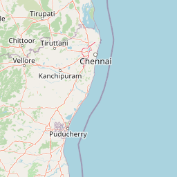
Use this park location map to pinpoint Sri Venkateswara National Park in India, understand its exact geographic position, and read its mapped placement within the surrounding landscape more clearly.

Pigeon | © OpenStreetMap contributors

Location context for Sri Venkateswara National Park

Andhra PradeshTirupati district
Park atlas

Map the regional park geography and compare contiguous protected landscapes across the Eastern Ghats mountain range.

Compare Other National Parks and Protected Areas Near Sri Venkateswara National Park
After exploring Sri Venkateswara National Park, browse other national parks and protected areas across the Eastern Ghats mountain range, continuing your regional park discovery. Compare diverse conservation landscapes, map shared ecological zones, and trace interconnected protected territories to deepen your atlas-based understanding of India's natural heritage.
National parkTamil Nadu

Guindy National Park: Exploring its Protected Area Identity and Geographic Setting in Tamil Nadu

National park terrain and mapped boundaries for regional context.

Guindy National Park represents a significant protected natural landscape within Tamil Nadu, India. This entry provides detailed geographic context, focusing on the park's mapped boundaries and its identity as a national park. Users can delve into the regional landscape, understanding how Guindy National Park contributes to the atlas of protected areas in South India and appreciating its specific natural terrain.

Area
2.706 km²
Established
1977
IUCN
II
Visitors
700K annual
National parkAndhra Pradesh

Rajiv Gandhi National Park (Rameswaram) National Park: Exploring Andhra Pradesh's Protected Landscapes

Mapped geography and protected area context for Rajiv Gandhi National Park (Rameswaram).

Delve into the geographic identity of Rajiv Gandhi National Park (Rameswaram), a key protected area within Andhra Pradesh. This detail page serves as an atlas anchor for understanding the park's landscape, mapped features, and its significance as a national park. Users can explore its protected boundaries and appreciate its role within the regional geography of Andhra Pradesh.

Area
2.4 km²
Established
2005
IUCN
II
Relief
Lowland
Watercolor illustration showing mountains, a winding river, and green vegetation
National parkKarnataka

Bannerghatta National Park: A National Park in Karnataka with Mapped Geographic Identity

Explore the protected landscape and regional terrain context.

Bannerghatta National Park is an important protected area within the state of Karnataka, India. Its designation as a national park signifies its role in preserving regional natural landscapes and providing valuable geographic context for atlas exploration. Users can examine its mapped boundaries and understand its placement within the diverse terrain characteristic of South India and the Western Ghats, contributing to a structured understanding of protected lands.

Area
260.51 km²
Established
1974
IUCN
II
Relief
Mountain
National parkKarnataka

Bandipur National Park: Karnataka's Protected Landscape and National Park Atlas Entry

Discover mapped terrain and diverse forest ecosystems in South India.

Bandipur National Park, a prominent national park within Karnataka, serves as a vital hub for understanding protected area geography and landscape diversity. Its ecological significance is amplified by its location at the intersection of the Deccan Plateau and the Western Ghats, supporting a unique blend of forest types and rich biodiversity. This entry provides essential context for atlas-based discovery, detailing the park's mapped terrain, its role as a tiger reserve, and its contribution to the Nilgiri Biosphere Reserve's conservation landscape.

Area
1,456.3 km²
Established
1973
IUCN
II
Relief
Mixed relief
Watercolor painting showing green fields, pink and yellow areas, and distant mountains
National parkNilgiri District

Mudumalai National Park: National Park Identity and Geographic Context in Nilgiri District

Mapped protected area and natural terrain details for this key Indian park.

Delve into the specific geographic identity of Mudumalai National Park, a protected national park situated in the Nilgiri District. This detail page provides access to its mapped natural landscape, helping users understand its protected boundaries and regional geographic significance. It serves as a foundational point for exploring the park's unique terrain within India's atlas of natural protected areas.

Area
321 km²
Established
1940
IUCN
II
Relief
Mountain
National parkKarnataka

Nagarahole National Park: National Park within Karnataka's Protected Geography

Explore mapped boundaries and regional landscape context.

Nagarahole National Park stands as a distinct national park entity within the state of Karnataka, India. This section focuses on its specific geographic footprint and the protected landscape it encompasses, offering valuable data for users engaged in atlas-based discovery of India's conservation areas and natural terrains. Understand its mapped geography and regional significance.

Area
847.98 km²
Established
1983
IUCN
II
Relief
Upland
National parkTelangana

Mrugavani National Park: Telangana's Protected Area within the Deccan Plateau's Natural Landscape

Explore undulating terrain and tropical dry forest ecosystems.

Mrugavani National Park represents a significant protected landscape within Telangana, India, characterized by its characteristic Deccan Plateau geography. Covering 1,211 acres, this national park features a terrain of rocky outcrops and undulating topography supporting a tropical dry deciduous forest ecosystem. It serves as a critical refuge for native flora and fauna, including a notable population of spotted deer, and offers a valuable case study in regional conservation and mapped protected areas near urban centers.

Area
4.9 km²
Established
1994
IUCN
II
Relief
Upland
National parkNilgiri District

Mukurthi National Park: Nilgiri District's Protected Montane Grassland and Shola Ecosystem

Explore a vital refuge for the endangered Nilgiri tahr.

Mukurthi National Park, situated in the Nilgiri District of India, is an essential protected area celebrated for its distinctive montane landscape. This national park plays a critical role in the survival of the endangered Nilgiri tahr, protecting the rare shola-grassland ecosystem where they thrive. Its dramatic terrain, high elevations, and unique ecological associations make it a focal point for understanding conservation geography and the mapped boundaries of protected lands within the Western Ghats.

Area
78.46 km²
Established
1990
IUCN
II
Relief
Mountain

Common questions about visiting, size, designation, and location context for Sri Venkateswara National Park

Sri Venkateswara National Park FAQs for park facts, access, geography, and protected area context
Find quick answers about Sri Venkateswara National Park, including protected-area facts, park geography, trail and visitor context, and how the park fits into its surrounding country and regional landscape.
MoriAtlas Explorer

Continue Your Protected Areas Search Across the Global Atlas

Deepen your exploration by continuing the structured search for national parks and protected areas worldwide. Utilize the comprehensive filtering capabilities to compare different conservation landscapes and refine your understanding of global park geography. Discover more about the distribution and characteristics of protected natural areas.

Global natural geography