

Mori Atlas logo
National parkTaean Seaside National Park

Discover the mapped boundaries and regional geography of this national park.

Taean Seaside National Park: South Korea's Protected Coastal Landscape Atlas

Taean Seaside National Park, situated within the Republic of Korea, represents a significant protected natural landscape. This page provides an atlas-oriented view, detailing the park's geographic setting and its contribution to the mapped protected areas of the Korean Peninsula. Explore the natural terrain and understand the specific context of this national park in East Asia.

coastal national parkYellow Seabeachesislandsmarine conservationsand dunes

Taean Seaside National Park

National park

Park overview

Structured park overview, official facts, and landscape profile for Taean Seaside National Park

Taean Seaside National Park park facts, protected area profile, and essential visitor context
Review the core facts for Taean Seaside National Park, including designation, size, terrain, visitor scale, habitats, and operating context in one park-focused overview.

About Taean Seaside National Park

Taean Seaside National Park represents a distinctive approach to Korean conservation, protecting a long stretch of the western coastline rather than the mountain ranges that dominate most of Korea's other national parks. The park's location on the Yellow Sea exposes it to the tidal patterns and marine conditions of this shallow sea, creating tidal flats, sand beaches, and rocky intertidal zones that support diverse communities of marine organisms. The 72 islands within the park range from small rocky outcrops used by seabirds to larger islands with their own coastal features. Sand dunes along certain sections of the coastline represent a rare coastal habitat type in Korea, supporting specialized dune-adapted plant species. The combination of marine and terrestrial habitats within a single protected area allows for the protection of entire coastal ecosystem complexes rather than isolated habitat types. This integrated approach to coastal conservation addresses both the above-water and underwater environments that together form the coastal ecological character of the region.

Quick facts and research context for Taean Seaside National Park

Taean Seaside National Park covers 840 square kilometers along Korea's western coast in South Chungcheong Province. Established in 1978 as the country's 13th national park, it is notable for its marine-dominated character, with approximately 749 square kilometers of marine area representing about 90 percent of the total protected surface. The park protects 72 islands, 26 beaches, coastal sand dunes, and rocky shoreline formations across 230 kilometers of coastline. The biodiversity inventory includes 1,195 animal species, 774 plant species, and 671 marine species. Notable marine mammals present in park waters include minke whales and finless porpoises. The park is managed by the Korea National Park Service.

Park context

Deeper park guide and search-rich context for Taean Seaside National Park

Taean Seaside National Park history, landscape, wildlife, and travel context
Explore Taean Seaside National Park through its history, landscape character, ecosystems, wildlife, conservation priorities, cultural context, and seasonal travel timing in a structured park guide built for atlas discovery and search intent.

Why Taean Seaside National Park stands out

Taean Seaside National Park is best known for its extensive coastal landscape diversity along the Yellow Sea, combining sandy beaches, dune systems, rugged rocky shores, and numerous islands into one protected coastal preserve. The park's marine ecosystems support significant populations of marine mammals including minke whales and finless porpoises, making it important for marine wildlife conservation on the Korean Peninsula. The diversity of coastal habitats from tidal flats to cliff faces creates conditions supporting both terrestrial and marine biodiversity. The park also stands out among Korea's national parks for its scale of marine protection, representing a coastal rather than mountainous conservation model that is relatively rare in the national park system.

Taean Seaside National Park history and protected-area timeline

Taean Seaside National Park was designated as South Korea's 13th national park on October 20, 1978, reflecting a period when the Korean national park system was expanding beyond its initial focus on mountainous terrain to include other significant natural landscapes. The establishment of a coastal national park marked recognition that Korea's coastal environments warranted the same level of protection as mountain ecosystems. At the time of designation, the park encompassed approximately 840 square kilometers, making it one of the larger protected areas in the system. The creation of Taean as a seaside national park also acknowledged the ecological and scenic value of Korea's western coastline, which had previously received limited formal protection despite its importance for wildlife, fisheries, and coastal communities. The park has been managed by the Korea National Park Service since its establishment, which provides ongoing protection, visitor services, and ecological management programs.

Taean Seaside National Park landscape and geographic character

The physical landscape of Taean Seaside National Park is defined by its coastal setting along the Yellow Sea, creating a mosaic of shoreline types that includes sandy beaches, pebbled shores, rocky cliffs, and tidal flats. The 230-kilometer coastline features 26 distinct beaches ranging from small coves to longer stretches of sand, each with characteristic profiles shaped by wave action and tidal patterns. Sand dunes occur in several locations along the coast, representing a distinctive landscape element that supports specialized vegetation communities adapted to shifting sandy substrates and saline conditions. The 72 islands within the park vary considerably in size and character, from tiny islets that appear only at low tide to larger islands with their own coastal cliffs and beach systems. Inland from the immediate shoreline, the terrestrial portions of the park include rolling terrain and coastal plain areas that connect to the marine environment through tidal channels and wetlands.

Taean Seaside National Park ecosystems, habitats, and plant life

The ecological character of Taean Seaside National Park reflects the convergence of terrestrial and marine environments along Korea's western coast. The park contains a variety of coastal ecosystems including sandy beach communities, dune vegetation, rocky shore intertidal zones, tidal flat systems, and surrounding marine waters. The marine component dominates the protected area, with the Yellow Sea's productive shallow waters supporting diverse plankton communities that in turn sustain fish populations and marine mammals. The 671 documented marine species within the park occupy various ecological niches from bottom-dwelling organisms to pelagic species. Terrestrial habitats support the 1,195 animal species and 774 plant species recorded in the park, including coastal forest patches, grassland areas, and wetland zones where fresh and salt water mix. The diversity of habitat types within a relatively compact area creates conditions for high biological productivity and species diversity.

Taean Seaside National Park wildlife and species highlights

The wildlife of Taean Seaside National Park encompasses both marine and terrestrial species, with the marine component particularly notable for the presence of cetaceans. Minke whales and finless porpoises are documented within park waters, representing the park's most recognizable marine mammalian residents. The finless porpoise, despite its name, is actually a small toothed whale and is considered a distinctive species of the Yellow Sea region. Among terrestrial wildlife, the park provides habitat for several species of conservation concern. The Eurasian otter inhabits coastal areas and waterways within the park, using the marine environment for foraging while resting in terrestrial riparian habitats. The Chinese egret, a specialist of coastal wetlands and tidal flats, uses the park's intertidal areas for foraging. The Seoul frog and the lizard species Eremias argus represent the park's amphibian and reptile diversity, occupying coastal habitats that provide appropriate conditions for these species. The combination of marine and terrestrial environments supports a broader range of wildlife than either habitat type alone would provide.

Taean Seaside National Park conservation status and protection priorities

Taean Seaside National Park plays a significant role in coastal conservation on the Korean Peninsula by protecting a substantial stretch of relatively undeveloped coastline in a region where industrial and agricultural pressures have heavily modified the western coast. The park's marine protection component addresses a conservation gap in Korea's protected area network, as most national parks focus on mountainous terrain rather than marine environments. The presence of endangered species including the Eurasian otter, Chinese egret, Seoul frog, and Eremias argus demonstrates the park's importance for species that depend on coastal habitats that have been lost or degraded in much of the region. The marine mammal populations, particularly finless porpoises, represent a conservation priority given the species' limited distribution and vulnerability to maritime traffic and fishing gear. The protection of the 72 islands provides nesting and resting habitat for seabirds and contributes to the preservation of island ecosystems that would otherwise face development pressure.

Taean Seaside National Park cultural meaning and human context

The coastal location of Taean Seaside National Park places it within a region with historical connections to maritime activities and coastal settlement patterns characteristic of Korea's western seaboard. Taean County has maintained agricultural and fishing traditions that reflect the broader cultural heritage of South Chungcheong Province. While the park itself is designated primarily for natural conservation rather than cultural protection, the surrounding landscape includes elements of the traditional coastal human environment that existed before modern conservation designations. The relationship between local communities and the coastal environment is evident in the historical patterns of fishing, salt production, and agriculture that have shaped the region's character. These human dimensions, while not the primary focus of the national park designation, provide context for understanding how the protected landscape fits within the broader regional identity.

Top sights and standout views in Taean Seaside National Park

The defining highlights of Taean Seaside National Park include its extensive coastline with 26 beaches, the distinctive sand dune systems that represent rare coastal habitat in Korea, and the 72 islands that add vertical dimension to the predominantly horizontal coastal landscape. The marine protected component, comprising approximately 90 percent of the park's area, makes it unique among Korean national parks for its marine conservation focus. Wildlife viewing opportunities center on marine mammals including minke whales and finless porpoises that can be observed from coastal viewpoints, while the endangered Eurasian otter and Chinese egret represent rare terrestrial species that fortunate visitors may encounter. The diversity of coastal scenery within a single protected area allows visitors to experience beach, dune, cliff, and island landscapes without traveling between separate destinations.

Best time to visit Taean Seaside National Park

The best time to visit Taean Seaside National Park depends on what visitors hope to experience, with each season offering distinct advantages for different activities. Spring and autumn generally offer comfortable temperatures for coastal walking and beach exploration, with moderate weather that allows extended time outdoors without summer's heat or winter's cold. These shoulder seasons also coincide with bird migration periods when the park's wetlands and tidal flats host transient species that augment the resident wildlife populations. Summer brings warmer conditions suitable for beach activities and swimming at the park's 26 beaches, though this is also the peak visitor period. Winter offers a quieter experience with fewer visitors and the opportunity to observe marine mammals from shore-based locations, though cold temperatures and limited facilities may constrain some activities. The park's marine environment is accessible year-round, though boat-based activities and marine wildlife viewing may be more comfortable during calmer weather periods.
Park location guide

Geography guide, regional context, and park location map for Taean Seaside National Park

Taean Seaside National Park park geography, regions, and map view in South Korea
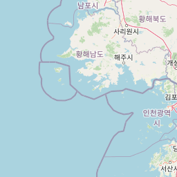
Understand where Taean Seaside National Park sits in South Korea through a broader geographic reading of the surrounding landscape, nearby location context, and its mapped position within the national park landscape.

How Taean Seaside National Park fits into South Korea

South Korea is a presidential republic on the Korean Peninsula in East Asia. It has a population of about 51 million and Seoul as its capital and largest city. The country is known for its rapid economic development, high technology industry, and cultural exports.

Wider geography shaping Taean Seaside National Park in South Korea

South Korea occupies the southern half of the Korean Peninsula in East Asia. It borders North Korea along the Demilitarized Zone to the north, the Yellow Sea to the west, and the Sea of Japan to the east. The terrain is predominantly mountainous with coastal plains along the southern and eastern shores.

Map view of Taean Seaside National Park

Use this park location map to pinpoint Taean Seaside National Park in South Korea, understand its exact geographic position, and read its mapped placement within the surrounding landscape more clearly.

Pigeon | © OpenStreetMap contributors

Location context for Taean Seaside National Park

South Chungcheong ProvinceTaean County
Park atlas

Uncover the Regional Context of South Korea's National Parks, from Marine Sanctuaries to Inland Reserves

Explore Other Coastal National Parks Near Taean Seaside National Park, South Korea
After exploring Taean Seaside National Park's unique coastal ecosystems and Yellow Sea marine habitats, continue browsing other national parks and protected areas within South Korea. Compare diverse park geographies, from coastal preserves and island systems to inland forest reserves, tracing the full scope of Korea's varied conservation landscapes.
National parkChungcheongnam-do

Gyeryongsan National Park: Mapped Protected Landscape in Chungcheongnam-do

Explore its national park designation and regional geography.

Gyeryongsan National Park is a formally protected national park in Chungcheongnam-do, South Korea. This page offers critical atlas context for understanding the park's geographic scope, mapped protected boundaries, and its significance as a natural landscape within the region. Examine the terrain and explore its regional context for a deeper appreciation of its protected status.

Area
64.71 km²
Established
1968
IUCN
II
Relief
Mountain
National parkGyeonggi Province

Bukhansan National Park: Protected Area Geography and Mapped Boundaries in Gyeonggi Province

Explore the landscape context of this national park.

Bukhansan National Park stands as a distinct protected area within Gyeonggi Province, offering a rich landscape for geographic exploration. This entry focuses on its identity as a national park, detailing its mapped boundaries and its contribution to the regional geography. Users can explore its protected landscape features and understand its significance through a structured, map-centric approach, enriching their atlas understanding of protected natural areas.

Area
79.92 km²
Established
1983
IUCN
II
Visitors
5M annual
National parkJeollabuk-do

Byeonsan-bando National Park: Protected Landscape and Geographic Context in Jeollabuk-do

Explore mapped terrain and regional park geography.

This detail page provides an in-depth look at Byeonsan-bando National Park, a protected area located in South Korea's Jeollabuk-do region. Users can discover the park's specific geographic identity, understand its mapped boundaries, and explore its role within the broader regional landscape. The content is structured for atlas exploration, offering detailed insights into the park's natural terrain and its significance as a national park.

Area
154.71 km²
Established
1988
IUCN
II
Relief
Mixed relief
National parkSouth Korea

Songnisan National Park: Mapped Protected Landscape and Geographic Context in South Korea

Discover South Korea's Songnisan National Park and its protected terrain.

Delve into the protected landscape of Songnisan National Park, a key national park entity in South Korea. This atlas-focused view highlights its mapped geographic boundaries and natural terrain, providing essential context for understanding conservation areas. Explore Songnisan National Park as a distinct protected region contributing to the country's diverse geography and mapped natural heritage.

Area
274.541 km²
Established
1970
IUCN
II
Relief
Mountain
National parkSouth Korea

Naejangsan National Park: South Korea's Mapped Protected Landscape and Geography

Discover the park's protected boundaries and regional context.

Investigate Naejangsan National Park, a protected area within South Korea, through its mapped geography and landscape context. This detailed atlas entry provides insight into the park's specific geographic identity and its role as a national park, offering a structured understanding of its protected natural features for focused exploration and research.

Area
81.45 km²
Established
1971
IUCN
II
Relief
Mountain
National parkJeollabuk-do

Deogyusan National Park: National Park Identity and Geographic Mapping

Explore its protected land boundaries and regional landscape context.

Examine Deogyusan National Park, a designated national park situated in the Jeollabuk-do region of South Korea. This entry provides critical geographic context, focusing on the park's mapped boundaries and its role as a protected landscape. Users can gain a structured understanding of its natural terrain and regional significance, contributing to a broader atlas of protected areas.

Area
231.65 km²
Established
1975
IUCN
V
Visitors
1M annual
National parkGangwon-do

Chiaksan National Park: National Park Protected Landscape and Geographic Context in Gangwon-do

Explore mapped boundaries and regional terrain.

Chiaksan National Park is a designated national park within South Korea's Gangwon-do region, offering a focused entry point for geographic discovery. This resource details the park's protected landscape, its mapped boundaries, and its relation to the surrounding natural terrain. Delve into the atlas-style context of Chiaksan National Park to understand its significance as a protected natural area within its regional geography.

Area
181.57 km²
Established
1984
IUCN
II
Relief
Mountain
Watercolor illustration of green hills, a body of water, and mountain peaks under a soft sky
National parkGyeongsangbuk-do

Woraksan National Park: A Key National Park in Gyeongsangbuk-do's Regional Geography

Discover its mapped mountain terrain and protected landscape identity.

Woraksan National Park offers a detailed view of protected mountain landscapes within South Korea's Gyeongsangbuk-do region. The park is characterized by its prominent Mount Worak, steep ridgelines, and dense forested terrain, contributing significantly to the nation's network of protected areas. Users can explore the geographic context, mapped boundaries, and ecological significance of this vital national park, understanding its place in the broader regional atlas and natural landscape context.

Area
287.78 km²
Established
1984
IUCN
II
Relief
Mountain

Common questions about visiting, size, designation, and location context for Taean Seaside National Park

Taean Seaside National Park FAQs for park facts, access, geography, and protected area context
Find quick answers about Taean Seaside National Park, including protected-area facts, park geography, trail and visitor context, and how the park fits into its surrounding country and regional landscape.
MoriAtlas Explorer

Continue Your Protected Areas Search Across the Global Atlas

Deepen your exploration by continuing the structured search for national parks and protected areas worldwide. Utilize the comprehensive filtering capabilities to compare different conservation landscapes and refine your understanding of global park geography. Discover more about the distribution and characteristics of protected natural areas.

Global natural geography