
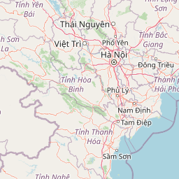
Mountain ranges
Park geography
Detailed terrain analysis including peak elevations, forest habitats, and regional context
Comprehensive Geographic Profile and Mapped Boundaries of Tam Dao National Park
This geographic profile covers the 368.83 square kilometer expanse of Tam Dao National Park within Vĩnh Phúc Province. It outlines the park's subtropical mountainous terrain, which features significant peaks reaching 1592 meters, complex valley systems, and a diverse range of forest and grassland habitats.
Related tags
mountain forestbiodiversity hotspotFrench colonial heritageendemic speciesmontane ecosystems
Northern Vietnam's mountain preserve with French colonial heritage and rich biodiversity
Tam Dao National Park
Tam Dao National Park is a protected area in northern Vietnam, established in 1996 and situated approximately 85 kilometers northwest of Hanoi. The park encompasses the Tam Đảo mountain range, a terminal spur of the larger northwestern Vietnamese highlands, spanning roughly 369 square kilometers across six districts and one city in Vĩnh Phúc, Tuyên Quang, and Thái Nguyên provinces. The range extends about 80 kilometers from northwest to southeast with more than 20 peaks exceeding 1,000 meters in altitude, the highest being Tam Đảo North at 1,592 meters. The area features a rich tapestry of forest ecosystems, from tropical moist evergreen forests at lower elevations through subtropical moist evergreen zones to high mountain short forests near the summits. The park's biodiversity is remarkable, with over 2,000 plant species documented, including 42 endemic species and 64 considered rare, alongside diverse fauna representing 64 mammal species, 239 bird species, 75 reptile species, and 28 amphibian species.
- Location
- Vietnam
- Park type
- National park
- Established
- 1996
- Area
- 368.8 km²
- Highest point
- 1,592 m
Location overview
Regional positions across Vĩnh Phúc Province and global territories
Tam Dao National Park Geographic Location and Regional Position
Tam Dao National Park is mapped within Vĩnh Phúc Province in Vietnam and associated with American Samoa. Clear geographic data maps country boundaries and regional administrative designations.
- Countries
- Vietnam
- Regions
- Vĩnh Phúc Province
- Primary location
- Vĩnh Phúc Province
Boundary and coordinates
Interactive protected-area geometry and calculated spatial metrics
Tam Dao National Park Boundary Map and Geographic Extent
Spatial context emerges directly from the mapped boundary outline of the protected area. Accompanying facts detail the recorded area span, perimeter dimensions, and geographic centre coordinates without claiming legal survey precision.
- Boundary area
- 327 km²
- Boundary perimeter
- 205.5 km
- Northernmost point
- 21.6856° N
- Southernmost point
- 21.3722° N
- Easternmost point
- 105.7255° E
- Westernmost point
- 105.4284° E
- Geographic centre
- 21.5264° N, 105.5833° E
- North–south span
- 34.7 km
- East–west span
- 30.8 km
Elevation and terrain
Vertical relief metrics and recorded natural features across the park
Tam Dao National Park Elevation Range and Mountain Terrain Geography
Recorded elevation ranges span from one hundred meters to fifteen hundred ninety two meters across this mountain park landscape. Linked feature cards provide names, types, measurements, and spatial relationships where documented.
- Minimum elevation
- 100 m
- Maximum elevation
- 1,592 m
- Highest point
- 1,592 m
Selected named natural features
Waterfalls
Thác Cửa Tử
Viewpoints
peak near tower
Peaks
Núi Thạch Bàn
1,388 m
Viewpoints
Thắc Bạc
Peaks
Tam Đảo Nord
1,592 m
Environmental setting
Subtropical mountain relief, forest cover, and habitat categories
Tam Dao National Park Environmental Classifications and Physical Setting
Recorded habitat types, relief types, and landscape features serve as complementary indicators for reading the physical setting of Tam Dao National Park. Connected atlas destinations link these stored environmental categories to wider regional protected-area geography.
- Relief
- Mountain
- Climate
- Subtropical
- Water
- Minor water
- Forest cover
- Mostly forested
Landscape features
Mountains · Valleys · Forest · Waterfalls
Habitat types
Tropical forest · Montane forest · Shrubland · Grassland · Temperate coniferous forest
Park atlas
Explore the surrounding regional park geography and compare protected landscapes adjacent to Tam Dao's mountain forest ecosystems.
Discover Other National Parks and Protected Areas Near Tam Dao National Park, Vietnam
Explore national parks and protected areas located near Tam Dao National Park, tracing similar mountain forest ecosystems and regional protected landscapes across northern Vietnam. A detailed geographic overview enables comparison of conservation efforts and landscape features, providing context for Tam Dao's unique biodiversity and colonial heritage.
National parkHanoi
About 46 km away#1 closest
South

Ba Vì National Park: Ancient Volcanic Mountains and Protected Landscape Near Hanoi
Discover the mapped geography and biodiversity of this national park.
Ba Vì National Park, a protected natural area near Hanoi, showcases a dramatic landscape shaped by ancient volcanic activity. The park features three significant peaks, including Vua Mountain, creating a distinct topographical profile. Spanning over 10,800 hectares, it is recognized for its ecological diversity, harboring a wealth of plant and animal species. This national park serves as a vital protected landscape, offering a unique opportunity for geographic exploration and understanding the natural terrain surrounding the Vietnamese capital.
- Area
- 108.15 km²
- Established
- 1991
- IUCN
- II
- Relief
- Mountain
National parkPhú Thọ Province
65 km away#2 closest
Southwest
Xuân Sơn National Park: Protected Mountain Landscape and Regional Geography
Mapping the southeastern edge of the Hoang Lien Mountains.
Delve into the protected landscape of Xuân Sơn National Park, a key national park situated in Phú Thọ Province, Vietnam. This area, covering about 150 square kilometers, is defined by its rugged mountainous terrain, featuring steep forested slopes and distinct ridgelines that contribute to the region's varied topography. As a protected national park, Xuân Sơn plays a crucial role in preserving the natural characteristics of the southeastern Hoang Lien Mountains. Its geographic setting is significant, acting as a transition zone between higher montane environments and the nearby lowland river systems, offering a unique perspective on Vietnam's diverse natural heritage.
- Area
- 150.48 km²
- Established
- 1986
- IUCN
- II
- Relief
- Mountain

National parkBắc Kạn Province
76 km away#3 closest
North
Ba Bể National Park: Vietnam's Largest Freshwater Karst Lake and Protected Landscape
Discover the mapped geography of this unique protected wetland in Bắc Kạn.
Ba Bể National Park is distinguished by Vietnam's largest natural freshwater lake, a perennial karst water body set within a dramatic limestone landscape. This national park in Bắc Kạn Province protects a vital wetland ecosystem and its surrounding highland forests, offering a rich geographic context for atlas exploration. Explore the park's unique terrain, mapped boundaries, and the remarkable biodiversity it preserves, making it a cornerstone of regional natural landscape discovery.
- Area
- 100.48 km²
- Established
- 1992
- IUCN
- II
- Relief
- Mixed relief
National parkNinh Bình Province
About 117 km away#4 closest
South
Cúc Phương National Park: National Park Atlas and Mapped Protected Landscape Details
Explore its geographic setting and protected area boundaries.
Gain structured insight into Cúc Phương National Park, a designated national park in Vietnam situated within Ninh Bình Province. This entry provides detailed geographic context, focusing on the park's mapped boundaries and its identity as a protected landscape. It is designed to support atlas-driven exploration and understanding of Vietnam's natural geography.
- Established
- 1962
- Relief
- Mountain
- Climate
- Tropical
- Access
- Moderate access
National parkVietnam
138 km away#5 closest
East
Cát Bà National Park: Vietnam's Critically Endangered Species Sanctuary & Karst Landscape
Mapped protected area with diverse terrestrial and marine ecosystems.
As a critical national park in Vietnam, Cát Bà National Park protects a remarkable limestone karst landscape central to the Hạ Long Bay region. This area is renowned for its steep peaks, narrow valleys, and coastal mangrove environments, supporting a uniquely diverse array of flora and fauna. Its status as a protected area highlights its global importance for conservation, particularly as the exclusive habitat of the Cát Bà langur. Explore the mapped geography and ecological significance of this vital Vietnamese protected land.
- Area
- 161.968 km²
- Established
- 1986
- IUCN
- II
- Relief
- Highland

National parkNam Định Province
About 152 km away#6 closest
Southeast
Xuân Thủy National Park: Protected Landscape Identity and Mapped Geography in Nam Định
Explore the national park's protected boundaries and regional landscape.
Xuân Thủy National Park serves as a vital protected landscape within Nam Định Province, Vietnam, offering users a clear point of entry for understanding its geographic identity. This page facilitates detailed exploration of its mapped park boundaries and the surrounding natural terrain, providing essential context for anyone interested in the regional geography of protected areas. Discover the specific landscape characteristics that define this national park and its place within Vietnam's conservation network.
- Area
- 7,100 km²
- Established
- 2003
- IUCN
- II
- Relief
- Lowland
National parkThanh Hóa Province
190 km away#7 closest
South
Ben En National Park: Vietnam National Park Geography and Mapped Landscape Context
Explore protected area boundaries and regional terrain.
Ben En National Park represents a key protected natural area within Thanh Hóa Province, Vietnam. This detail page facilitates a structured discovery of its geographic features, mapped extent, and its significance as a national park. Dive into the atlas context to understand the park's landscape and its regional setting, offering a factual foundation for geographic exploration.
- Area
- 147.35 km²
- Established
- 1992
- IUCN
- II
- Visitors
- 6.6K annual

National parkQuảng Ninh Province
About 201 km away#8 closest
East
Bái Tử Long National Park: Protected Island Archipelago and Marine Landscape Discovery
Explore the geography and mapped protected boundaries.
Bái Tử Long National Park, located in Vietnam's Quảng Ninh Province, is a protected national park distinguished by its archipelago of approximately 40 limestone islands and significant marine environments. As one of Vietnam's few national parks designated to protect both land and sea, it provides critical atlas-level insights into coastal karst topography, marine biodiversity, and the interconnectedness of island ecosystems. Discover the park's unique geographic features and its role as a vital protected landscape within the broader regional context.
- Area
- 157.83 km²
- Established
- 2001
- IUCN
- II
- Relief
- Mixed relief
MoriAtlas Explorer
Continue exploring the geographic context of Tam Dao National Park
Deepen your understanding of Tam Dao National Park's unique position within Vietnam's geography and its role as a protected landscape. Investigate its mapped terrain, distinctive montane ecosystems, and the broader regional context of Vĩnh Phúc Province through detailed geographic information and protected area data.
Browse next
Global natural geography
Explore related park routes
Explore MoriAtlas Global ParksBrowse All MoriAtlas ParksGlobal Park Map DiscoveryMoriAtlas: Browse All CountriesBrowse All MoriAtlas ContinentsNational Park Environment AtlasGrand Canyon National Park AtlasYellowstone National Park AtlasYosemite National Park Atlas and GeographySerengeti National Park AtlasGalápagos National Park Protected LandscapeBanff National Park Geography and AtlasKruger National Park Atlas EntryUluṟu-Kata Tjuṯa National Park AtlasExplore Uluru-Kata Tjuta National Park GeographyPlitvice Lakes National Park AtlasFiordland National Park Protected LandscapeGreat Smoky Mountains National Park AtlasAfghanistan National Parks and Protected AreasAlbania National Parks and Protected AreasAlgeria National Parks and Protected AreasAmerican Samoa National Parks and Protected AreasAndorra National Parks and Protected AreasAngola National Parks and Protected AreasAntarctica National Parks and Protected AreasAntigua and Barbuda Park List