Mori Atlas logo
National parkTaman Negara

Discover this significant national park within Pahang, Malaysia's vast natural terrain.

Taman Negara National Park: Explore Protected Landscape Geography and Mapped Boundaries

(Taman Negara (King George V National Park, 1938-1939))

Taman Negara National Park stands as a vital protected area within the expansive geography of Pahang, Malaysia. This page offers an atlas-centric view of Taman Negara, focusing on its mapped boundaries and its role within the regional landscape context. Understand the park's protected land identity and its place in the broader geographical framework of Peninsular Malaysia.

Tropical RainforestOld-Growth ForestNational ParkPeninsular MalaysiaMount TahanEcotourism

Taman Negara

National park

Park overview

Structured park overview, official facts, and landscape profile for Taman Negara

Taman Negara park facts, protected area profile, and essential visitor context

Review the core facts for Taman Negara, including designation, size, terrain, visitor scale, habitats, and operating context in one park-focused overview.

About Taman Negara

Taman Negara represents one of Southeast Asia's most significant protected rainforest areas, spanning the boundaries of three Malaysian states in the heart of Peninsular Malaysia. The park was established following the efforts of Theodore Hubback, who successfully lobbied the sultans of Pahang, Terengganu, and Kelantan to set aside this vast tract of land for protection in 1938 and 1939, initially as King George V National Park. The area encompasses the Tahan Range, a subrange of the Tenasserim Hills, with Mount Tahan standing as the crown jewel at 2,187 meters, the loftiest summit in all of Peninsular Malaysia. The park's geological foundation rests on ancient sedimentary rocks, and the landscape predominantly consists of rolling hills that have been worn down over immense spans of time. Despite its age and historical significance, the park remains a living ecosystem, with the three major river systems of Lebir, Terengganu, and Tembeling originating within its boundaries and flowing outward to serve the water needs of downstream communities. The park functions as an important ecological corridor and watershed, providing ecosystem services that extend far beyond its immediate borders. Visitors access the main park headquarters at Kuala Tahan in Pahang, where a range of accommodations and visitor facilities have developed around the park's ecotourism offerings.

Quick facts and research context for Taman Negara

Taman Negara spans 4,343 square kilometers across Pahang, Kelantan, and Terengganu states in Peninsular Malaysia, making it the largest national park in Peninsular Malaysia and one of the oldest protected tropical rainforests in the world at over 130 million years. The park contains Mount Tahan, Peninsular Malaysia's highest point at 2,187 meters above sea level, and serves as the headwaters for three major river systems: the Lebir, Terengganu, and Tembeling Rivers. Managed by the Department of Wildlife and National Parks, the park features a canopy walkway near Kuala Tahan, the Gua Telinga cave system, and Lata Berkoh rapids as major visitor attractions. The park is situated on the traditional territory of several Orang Asli groups, including the Batek people, whose use rights are legally recognized within the park's legislation.

Protection and recognition

Verifying documented conservation boundaries, terrestrial scope, and global designation data

Taman Negara Protection Status and Terrestrial Conservation Designations

National park enthusiasts can explore the documented terrestrial protection status and formal boundaries established to safeguard Taman Negara. Analyzing verified terrestrial boundaries and official designation history provides essential geographic context for understanding how the habitat fits into regional conservation frameworks.

Protection details

Protection scope
Terrestrial
Transboundary protection
No
Park context

Deeper park guide and search-rich context for Taman Negara

Taman Negara history, landscape, wildlife, and travel context

Explore Taman Negara through its history, landscape character, ecosystems, wildlife, conservation priorities, cultural context, and seasonal travel timing in a structured park guide built for atlas discovery and search intent.

Why Taman Negara stands out

Taman Negara is renowned as one of Earth's oldest tropical rainforests, a designation that draws nature enthusiasts and researchers from around the world. The park is particularly famous for its ancient dipterocarp forest ecosystem, which has remained largely undisturbed for millions of years, preserving a remarkable level of biodiversity. Visitors are drawn to the iconic canopy walkway that provides access to the forest's uppermost levels, offering intimate views of the complex ecosystem that thrives in the tree canopy. The park's wildlife includes significant populations of endangered species such as the Malayan tiger, Malayan gaur, and Asian elephant, as well as notable bird species including the great argus and Malayan peacock-pheasant. The Lata Berkoh rapids and the Tahan River provide scenic river-based experiences that complement the terrestrial exploration opportunities.

Taman Negara history and protected-area timeline

Taman Negara's establishment in 1938 and 1939 marked a pioneering effort in Malaysian conservation history, representing the nation's first and oldest officially protected area. The park was originally named King George V National Park in honor of the British monarch, established through the collaborative efforts of colonial-era administrator Theodore Hubback, who successfully convinced the sultans of the three affected states to set aside this land for protection. Each state enacted its own legislation governing the park: the Taman Negara Enactment (Pahang) No. 2 of 1939, the Taman Negara Enactment (Kelantan) No. 14 of 1938, and the Taman Negara Enactment (Terengganu) No. 6 of 1939. Following Malaysia's independence in 1957, the park was renamed Taman Negara, reflecting the new national identity. The park legislation notably includes provisions recognizing the traditional use rights of Orang Asli communities within the park boundaries, particularly in section 15(c) of the Pahang enactment. Over the decades, the park has developed as an ecotourism destination while maintaining its conservation mandate, with the Department of Wildlife and National Parks overseeing management across all three state jurisdictions.

Taman Negara landscape and geographic character

The terrain of Taman Negara presents a diverse physical landscape dominated by ancient, eroded sedimentary formations that constitute some of the oldest bedrock in the Malay Peninsula. Approximately 57 percent of the park's total area consists of gentle rolling hills lying below 300 meters above sea level, the result of prolonged erosion over millions of years. However, the landscape transforms dramatically in the Tahan Range, a northern subrange of the Tenasserim Hills that contains the park's most imposing topography. Mount Tahan rises to 2,187 meters above sea level, standing as the highest peak in Peninsular Malaysia and creating a dramatic backdrop to the surrounding forest. The park's hydrological significance is profound, serving as the source area for three major river systems that sustain communities and ecosystems across multiple states. The Lebir River flows northward to join the Kelantan River and ultimately the Kelantan Delta, the Terengganu River discharges eastward toward Kenyir Lake, and the Tembeling River carries its waters southward to join the Pahang River in the central valley of Pahang. This extensive river network has carved valleys through the terrain, creating the diverse microhabitats that support the park's rich biodiversity.

Taman Negara ecosystems, habitats, and plant life

Taman Negara protects one of the world's most ecologically significant tropical rainforest ecosystems, encompassing both lowland dipterocarp forests and montane rainforests at higher elevations. The lowland portions feature predominantly virgin, old-growth dipterocarp forest, characterized by the family Dipterocarpaceae that dominates Southeast Asian rainforests. These forests display the complex vertical structure typical of mature tropical rainforests, with emergent trees reaching toward the canopy, a dense middle story, and a layered understory. At higher elevations in the Tahan Range, the vegetation transitions to montane rainforest, where different species assemblages adapted to cooler, cloudier conditions prevail. The park's age, estimated at more than 130 million years, has allowed evolutionary processes to proceed uninterrupted, generating exceptional biodiversity. The forest supports approximately 10,000 plant species, creating a complex ecosystem where epiphytes, lianas, and buttressed trees form the distinctive rainforest architecture. The canopy walkway provides visitors with a unique perspective on this vertical world, allowing observation of the rich life that inhabits the forest's upper reaches.

Taman Negara wildlife and species highlights

Taman Negara supports an impressive array of wildlife, with documented populations including approximately 200 mammal species, 675 bird species, 270 reptile species, 250 freshwater fish species, and tens of thousands of insect and invertebrate species. The park is particularly notable for its population of large mammals, including endangered species such as the Malayan tiger, one of the most elusive predators in Asian forests, and the Asian elephant, which roams the park's forest floors in search of vegetation. The Malayan gaur, known locally as seladang, represents another impressive bovid found within the park's boundaries. Some biologists believe a small population of the critically endangered Northern Sumatran Rhinoceros may still persist in the park's remote areas. The bird population includes the great argus, a striking pheasant known for its elaborate display, the red junglefowl, ancestor of the domestic chicken, and the rare Malayan peacock-pheasant with its iridescent plumage. The Tahan River has been specifically preserved to protect the Malaysian mahseer, known locally as ikan kelah, a prized game fish that attracts anglers to the park's waters. The diversity of smaller wildlife, including primates, civets, squirrels, and countless invertebrate species, contributes to the park's ecological richness.

Taman Negara conservation status and protection priorities

Taman Negara serves as a critical conservation area for Peninsular Malaysia's rainforest ecosystems, protecting both the lowland dipterocarp and montane rainforest ecoregions that have become increasingly fragmented across the region. The park's designation as IUCN Category II reflects its primary mandate of protecting natural ecosystems while allowing for sustainable visitor use and environmental education. Its large contiguous area provides essential habitat for populations of endangered species including the Malayan tiger and Asian elephant, both of which require extensive territories to maintain viable populations. The forest also serves as a crucial watershed, protecting water quality and regulating flow for rivers that support millions of people downstream in the three states. The recognition of Orang Asli use rights within the park represents an integrated approach to conservation that acknowledges the historical relationship between indigenous communities and the land, though this arrangement also requires careful management to balance traditional practices with ecological protection. The park's status as the oldest protected area in Malaysia provides a model for conservation planning and demonstrates the long-term viability of maintaining large forest reserves in the region.

Taman Negara cultural meaning and human context

Taman Negara exists within a landscape of profound cultural significance, as it encompasses the traditional territories of several Orang Asli groups, the indigenous peoples of Peninsular Malaysia. The Batek people represent one of the most prominent communities associated with the park, continuing to inhabit the periphery of the protected area and maintaining their traditional connections to the forest. Malaysian law explicitly recognizes the use rights of Orang Asli within Taman Negara, with legislation such as section 15(c) of the Pahang Enactment of 1939 codifying these rights. Six distinct Orang Asli groups are recognized within the park's context: the Ple, Temiar, Ple-Temiar, Senoi, Semang, and Pangan communities, each with their own cultural traditions and relationships to the landscape. This recognition distinguishes Taman Negara from purely exclusionary conservation models, instead acknowledging that indigenous peoples have historically inhabited and managed these lands in ways compatible with forest preservation. Visitors to the park may encounter Orang Asli communities and learn about their traditional knowledge of the forest, though such interactions are carefully managed to respect cultural boundaries and maintain the integrity of both conservation goals and indigenous communities.

Top sights and standout views in Taman Negara

Taman Negara offers visitors an unparalleled opportunity to experience one of Earth's oldest rainforests, with the iconic canopy walkway providing access to the forest's upper levels and panoramic views of the verdant landscape stretching to the horizon. The ascent to Mount Tahan represents a significant challenge for hikers, with the summit offering sweeping vistas from the highest point in Peninsular Malaysia. The river-based attractions, including the Lata Berkoh rapids and the Tahan River, provide opportunities for boat trips, swimming, and fishing for the prized Malaysian mahseer. The Gua Telinga cave system offers exploration opportunities for those interested in geological formations. The park's wildlife, including the possibility of encountering Malayan tigers, Asian elephants, and various primate species, draws wildlife enthusiasts from around the world. Birdwatchers find particular value in the diverse avifauna, with species such as the great argus and Malayan peacock-pheasant providing memorable sightings. The presence of Orang Asli communities on the park's periphery offers cultural dimensions to the visit.

Best time to visit Taman Negara

Taman Negara can be visited throughout the year, though the experiences vary with the seasons in this tropical rainforest environment. The dry season, typically from December to April, generally offers more comfortable conditions for hiking and outdoor activities, with reduced rainfall making trail conditions more accessible. However, tropical rainforests maintain their lush appearance year-round, and even the wetter months from May to November have their own appeal, with waterfalls often at their most impressive and the forest displaying its full verdant character. The monsoon season can bring heavier rainfall and higher river levels, which may affect some activities but also creates atmospheric conditions favored by photographers and those seeking a different perspective on the forest. Wildlife viewing remains possible in all seasons, though animals may be more active during cooler morning and evening hours. The park's popularity means that booking accommodations in advance is advisable, particularly during holiday periods and weekends.

Monthly climate preview

Analyzing monthly weather averages and precipitation trends in the Pahang rainforest

Taman Negara Climate Profile: Annual Temperature and Precipitation Normals

Long-term records at a representative elevation of 285 meters show a consistent tropical temperature pattern for Taman Negara, with mean monthly temperatures hovering between 23 and 26 degrees Celsius. Examining the full monthly breakdown reveals the distinct precipitation cycle of the Pahang region, including the heavier rainfall peaks in November and December.
Annual mean25 °C
24 °C26 °C
Jan24°
Feb24°
Mar25°
Apr25°
May26°
Jun25°
Jul25°
Aug25°
Sep25°
Oct25°
Nov25°
Dec24°
Warmest month
May

25.6 °C

Coolest month
January

23.6 °C

Wettest month
December

15.8 mm/day

Driest month
February

4.5 mm/day

Park location guide

Geography guide, regional context, and park location map for Taman Negara

Taman Negara park geography, regions, and map view in Malaysia

Understand where Taman Negara sits in Malaysia through a broader geographic reading of the surrounding landscape, nearby location context, and its mapped position within the national park landscape.

How Taman Negara fits into Malaysia

Malaysia is a federal constitutional monarchy located in Southeast Asia. The country consists of 13 states and three federal territories, divided by the South China Sea into Peninsular Malaysia on the Indochinese Peninsula and East Malaysia on the island of Borneo. With a population of over 34 million, it achieved independence from Britain in 1957 and became a modern federation in 1963. The country is recognized for its multicultural population, tropical climate, and significant economic role in the region.

Wider geography shaping Taman Negara in Malaysia

Malaysia occupies a strategic position in Southeast Asia, split by the South China Sea into two distinct regions. Peninsular Malaysia lies on the Indochinese Peninsula, sharing a land border with Thailand to the north and maritime borders with Singapore, Vietnam, and Indonesia. East Malaysia occupies the northern portion of Borneo, sharing land borders with Brunei and Indonesia, and maritime borders with the Philippines and Vietnam. The country's terrain includes coastal plains, mountain ranges such as the Titiwangsa in the peninsula, and extensive tropical rainforests.

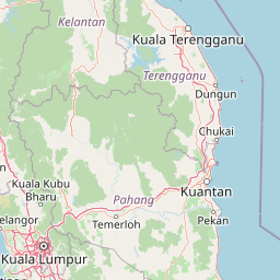
Map view of Taman Negara

Use this park location map to pinpoint Taman Negara in Malaysia, understand its exact geographic position, and read its mapped placement within the surrounding landscape more clearly.

Pigeon | © OpenStreetMap contributors

Location context for Taman Negara

KelantanPahangTerengganu
Park atlas

Uncover the geographic context of protected landscapes across Peninsular Malaysia, tracing areas connected to Taman Negara's ancient rainforest.

Explore More National Parks Near Taman Negara and Discover Related Protected Areas

After exploring Taman Negara, browse national parks and protected areas across Peninsular Malaysia, including those within its surrounding states of Pahang, Kelantan, and Terengganu. Compare diverse conservation landscapes, from ancient rainforests to mountainous terrain and vital river systems, tracing the regional spread of protected geography.
Protected areaTerengganu
About 106 km away#1 closest

Northeast

Kapas Island: A Detailed Geographic Overview of the Protected Terengganu Coastal Landscape

Topography, Marine Protection Zones, and Island Geography

Kapas Island offers a focused look at the intersection of coastal geography and conservation management. This small archipelago features a tropical jungle core and protected sandy perimeters, providing a clear map of local reef health and coastal biodiversity in the Terengganu region of Malaysia.

Area
1.5 km²
Relief
Lowland
Climate
Tropical
Access
Easy access
State or regional parkTerengganu
About 111 km away#2 closest

North

Setiu Wetlands State Park: Geography and Protected Area Atlas of Terengganu

Coastal lagoons, mangrove forests, and riverine ecosystems

Encompassing the largest natural wetland on Malaysia's east coast, Setiu Wetlands State Park serves as a critical protected landscape where sea, sand, and forest meet. This atlas entry details the park's 23,000 hectare expanse, highlighting the complex hydrological network of lagoons and river basins that support diverse habitats, including peat swamps and seagrass beds.

Area
230 km²
Established
2018
Relief
Lowland
Climate
Tropical
Wildlife reservePahang
About 113 km away#3 closest

South

Tengku Hassanal Wildlife Reserve: Protected Forest and Mountain Geography in Pahang

Mapping a vast lowland dipterocarp forest sanctuary.

Spanning over 600 square kilometers, Tengku Hassanal Wildlife Reserve stands as a core protected area within Pahang. Its landscape includes riverine valleys and the steep montane terrain of the Benom Complex, supporting unique biodiversity and active wildlife conservation. This overview traces the park's geographic footprint and its role as an ecological corridor within the broader Titiwangsa mountain system.

Area
605.52 km²
Established
1923
Relief
Mountain
Climate
Tropical
Marine protected areaTerengganu
About 128 km away#4 closest

North

Lang Tengah Island Marine Protected Area: Geography, Reefs, and Island Terrain

A tranquil protected landscape in the Terengganu archipelago

Lang Tengah Island represents a significant marine protected area defined by its dense forested interior and surrounding coral reef ecosystems. Located within the Terengganu marine region, the island offers a unique study of protected coastal geography, seasonal turtle nesting grounds, and undisturbed tropical marine environments separated from more developed nearby archipelagos.

Area
1.3 km²
Relief
Lowland
Climate
Tropical
Access
Moderate access
Marine protected areaTerengganu
About 134 km away#5 closest

Northeast

Redang Island Marine Protected Area: Coastal Terrain and Reef Ecosystems

Geographic atlas of the Terengganu island archipelago

Redang Island is a prominent marine protected area within the South China Sea, characterized by its forested interior, sheltered bays like Teluk Dalam, and expansive coral reef systems. As a key ecological site off the Terengganu coast, the island provides a unique study in island geography and marine conservation, offering detailed insights into the protected reef environments and coastal morphology of Peninsular Malaysia.

Area
24.2 km²
Relief
Upland
Climate
Tropical
Access
Moderate access
Protected areaTerengganu
About 135 km away#6 closest

East

Tenggol Island: A Geographic Overview of Terengganu's Protected Tropical Marine Landscape

Mapping reefs, forest interior, and regional maritime terrain

Tenggol Island stands as a distinct protected area off the coast of Terengganu, defined by its sharp 272-meter forested peak and complex underwater topography. This overview provides data on its coastal bays, rocky points, and fringing reef zones, offering a clear understanding of the island's unique position within the East Coast of Peninsular Malaysia's marine geography.

Area
2.62 km²
Relief
Upland
Climate
Tropical
Access
Moderate access
Marine protected areaTerengganu
About 138 km away#7 closest

North

Perhentian Islands Marine Protected Area: Terengganu Coastal and Archipelago Geography

Mapped marine boundaries and tropical island terrain

An immersive look at the Perhentian Islands, a protected nine-island archipelago in the South China Sea. Analyze the distinct marine geography, from fringing coral reefs and shallow reef flats to the forested inland hills of Perhentian Besar and Perhentian Kecil. This overview provides spatial context for one of Malaysia's most recognizable marine environments, emphasizing the protected status of its surrounding waters and reef habitats.

Area
15.955 km²
Established
1994
Relief
Lowland
Climate
Tropical
Biosphere reservePahang
About 149 km away#8 closest

South

Chini Lake Biosphere Reserve: Protected Freshwater Geography in Pahang, Malaysia

Examining the interconnected lake basins and tropical wetland terrain

Chini Lake is an essential protected freshwater system in Pahang, Malaysia, comprising a series of twelve connected lake basins and tropical forest margins. This landscape is a recognized UNESCO Biosphere Reserve, characterized by seasonal lotus blooms, peat-influenced wetlands, and deep cultural connections to the indigenous Jakun communities. Discover the geography and environmental context of this river-fed ecosystem.

Area
50.85 km²
Established
2019
Relief
Lowland
Climate
Tropical

Common questions about visiting, size, designation, and location context for Taman Negara

Taman Negara FAQs for park facts, access, geography, and protected area context

Find quick answers about Taman Negara, including protected-area facts, park geography, trail and visitor context, and how the park fits into its surrounding country and regional landscape.
MoriAtlas Explorer

Continue Your Protected Areas Search Across the Global Atlas

Deepen your exploration by continuing the structured search for national parks and protected areas worldwide. Utilize the comprehensive filtering capabilities to compare different conservation landscapes and refine your understanding of global park geography. Discover more about the distribution and characteristics of protected natural areas.

Global natural geography