

Mori Atlas logo
National parkTirgua National Park

Mapping the cloud forests, river valleys, and highland watersheds of this essential Venezuelan protected area

Tirgua National Park: A Deep Dive Into Protected Andean Mountain Landscapes in Venezuela

(Tirgua General Manuel Manrique National Park)

Tirgua National Park represents a significant protected area within the mountainous terrain of western Venezuela. Spanning the rugged highlands of Lara State, this park preserves essential cloud forest ecosystems and serves as a vital headwater region for the Tocuyo River basin. The landscape features steep Andean slopes, dramatic river valleys, and complex terrain that distinguish it from the surrounding lowland geography.

cloud forestsAndean protected areasVenezuelan parksmountain landscapeswaterfall destinationsLara State

Tirgua National Park

National park

Park overview

Structured park overview, official facts, and landscape profile for Tirgua National Park

Tirgua National Park park facts, protected area profile, and essential visitor context

Review the core facts for Tirgua National Park, including designation, size, terrain, visitor scale, habitats, and operating context in one park-focused overview.

About Tirgua National Park

Tirgua National Park is a protected area located in the mountainous region of Lara State in western Venezuela, within the Venezuelan Andes. The park encompasses a diverse landscape of cloud forests, Andean peaks, and river valleys that form part of the headwaters of the Tocuyo River basin. Established to protect the unique ecological systems of this highland region, the park serves as an important conservation area for neotropical mountain ecosystems. The area is characterized by its rugged terrain, frequent cloud cover, and rich biodiversity that distinguishes it from the surrounding dry lowlands of the Lara plains.

Quick facts and research context for Tirgua National Park

Tirgua National Park is situated in the Andes of western Venezuela, protecting important cloud forest habitats in Lara State. The park's terrain features steep mountain slopes, cascading waterfalls, and dense vegetation typical of premontane and montane forest zones. Its conservation significance stems from the protection of watersheds that supply water to nearby communities and agricultural areas, as well as the preservation of habitats for species adapted to high-elevation tropical environments.

Protection and recognition

Explore documented terrestrial protection parameters and management scope for Tirgua National Park.

Tirgua National Park Protection Status and Conservation Recognition

Tirgua National Park maintains a documented terrestrial protection scope without imported international recognition sources. Review structured conservation records and official designation parameters for this protected area.

Protection details

Protection scope
Terrestrial
Transboundary protection
No
Park context

Deeper park guide and search-rich context for Tirgua National Park

Tirgua National Park history, landscape, wildlife, and travel context

Explore Tirgua National Park through its history, landscape character, ecosystems, wildlife, conservation priorities, cultural context, and seasonal travel timing in a structured park guide built for atlas discovery and search intent.

Why Tirgua National Park stands out

Tirgua National Park is best known for its dramatic cloud forest landscapes, the Los Toros mountain sector with its iconic rock formations, and the extensive waterfall systems that cascade through the park's steep valleys. The park provides access to some of the most spectacular mountain scenery in Lara State, with trails that wind through pristine forest to viewpoints overlooking the Andean highlands.
Monthly climate preview

Long-term temperature and precipitation patterns across the protected terrain

Tirgua National Park Climate Normals and Annual Weather by Month

Historical climate records from 1991 to 2020 document measured monthly temperature ranges and precipitation shifts across the representative coordinate of Tirgua National Park. Examining the complete twelve-month profile provides deeper context for comparing long-term average conditions throughout the protected area.
Annual mean25 °C
24 °C26 °C
Jan24°
Feb25°
Mar26°
Apr26°
May26°
Jun25°
Jul24°
Aug24°
Sep25°
Oct25°
Nov25°
Dec24°
Warmest month
April

26.2 °C

Coolest month
July

24.3 °C

Wettest month
July

4.2 mm/day

Driest month
February

0.5 mm/day

Park location guide

Geography guide, regional context, and park location map for Tirgua National Park

Tirgua National Park park geography, regions, and map view in Venezuela

Understand where Tirgua National Park sits in Venezuela through a broader geographic reading of the surrounding landscape, nearby location context, and its mapped position within the national park landscape.

How Tirgua National Park fits into Venezuela

Venezuela is a country in northern South America with coastline along the Caribbean Sea and Atlantic Ocean. It borders Colombia, Brazil, Guyana, and Trinidad and Tobago. The country has an area of approximately 916,445 km² and a population of about 31.8 million. Caracas is the capital and largest city. Venezuela consists of 23 states and the Capital District.

Wider geography shaping Tirgua National Park in Venezuela

Venezuela is located on the northern coast of South America. The continental territory is bordered by the Caribbean Sea and Atlantic Ocean to the north, Colombia to the west, Brazil to the south, and Guyana to the east. Trinidad and Tobago lies to the northeast. The country includes various islands and islets in the Caribbean Sea known as the Federal Dependencies.

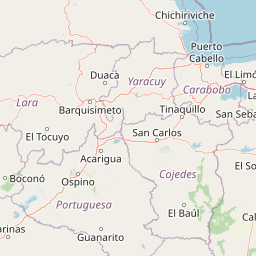
Map view of Tirgua National Park

Use this park location map to pinpoint Tirgua National Park in Venezuela, understand its exact geographic position, and read its mapped placement within the surrounding landscape more clearly.

Pigeon | © OpenStreetMap contributors
Park atlas

Compare adjacent highland reserves and regional Andean protected landscapes

Explore Protected Areas and Mountain Parks Near Tirgua National Park

Browsing parks near Tirgua National Park reveals connected conservation corridors across the rugged Venezuelan Andes. Expanding regional comparison helps trace broader mountain ecosystems and watershed protection zones throughout the surrounding highland terrain.
National parkCojedes
About 1.6 km away#1 closest

North

Parque Nacional Tirgua: Mapping Protected Foothills and River Systems in Cojedes

A vital watershed preservation unit in the Venezuelan piedmont.

Spanning the border between Cojedes and Yaracuy, Parque Nacional Tirgua acts as a significant ecological refuge defined by its irregular, hilly terrain. The area protects the source of the Tirgua River, regulating regional water flow through a mosaic of seasonal forests and broken slopes. This geographic context highlights the importance of the park within the broader network of Venezuelan protected lands.

Area
910 km²
Established
1992
IUCN
II
Relief
Upland
National parkVenezuela
About 66 km away#2 closest

West

Terepaima National Park: Venezuela's National Park Protected Landscape

Mapped Boundaries and Regional Geography

Terepaima National Park is a designated national park within Venezuela, offering a clear focus for atlas-driven exploration of protected natural areas. This entry highlights the park's significance as a mapped protected landscape, providing essential geographic context and detail for understanding its boundaries and regional setting. It is an integral component for any structured discovery of Venezuela's conservation network.

Area
186.5 km²
Established
1976
IUCN
II
Relief
Mountain
National parkVenezuela
About 68 km away#3 closest

North

Yurubí National Park: A National Park in Venezuela for Protected Landscape Exploration

Explore mapped boundaries and regional geography.

Yurubí National Park represents a distinct protected area within Venezuela, offering valuable data for geographic exploration and atlas-based understanding. This national park's identity is defined by its mapped boundaries and its role in the regional landscape context of northern South America. Delve into its protected territory to gain insights into Venezuela's natural geography and conservation landscapes.

Area
236.7 km²
Established
1960
IUCN
II
Relief
Mountain
National parkCarabobo
About 96 km away#4 closest

Northeast

San Esteban National Park: Discover Carabobo's Protected Caribbean Forest Landscape

Mapped protected area and natural terrain in Venezuela.

San Esteban National Park represents a significant protected area within Venezuela's Carabobo region, offering a unique exploration of Caribbean forest ecosystems and historical cultural sites. Covering approximately 445 square kilometers, the park's terrain spans coastal areas to mountainous interiors, presenting a diverse natural landscape shaped by its position in the coastal mountain ranges. This national park is notable for its archaeological petroglyphs, colonial roads, and fortifications, providing a rich cultural heritage context alongside its natural ecosystems. Its status as a protected national park makes it a key destination for understanding the intersection of natural conservation and historical geography in Venezuela.

Area
445 km²
Established
1987
IUCN
II
Relief
Mixed relief
National parkLara State
About 99 km away#5 closest

Northwest

Cerro Saroche National Park: A National Park within Lara State's Geography

Explore the protected landscape and mapped boundaries.

Cerro Saroche National Park in Lara State, Venezuela, is a distinct protected area offering a valuable perspective for geographic and atlas exploration. This page provides essential details about its identity as a national park, highlighting its place within the regional landscape. Understanding Cerro Saroche National Park helps in appreciating the distribution of protected lands and their geographical significance across Venezuela.

Area
322.94 km²
Established
1989
IUCN
II
Relief
Mountain
Watercolor painting depicting mountains, a lake, and green vegetation
National parkVenezuela
About 102 km away#6 closest

Northeast

Henri Pittier National Park: Venezuela's Oldest National Park, Coastal Range Geography

Explore protected landscapes, cloud forests, and birdwatching geography.

Henri Pittier National Park is Venezuela's foundational protected area, established in 1937 and spanning over 107,800 hectares within the Venezuelan Coastal Range. This national park is renowned for its exceptional biodiversity, particularly its over 500 bird species and its distinctive cloud forest ecosystems, which include the iconic Gyranthera caribensis tree. The park's geography extends from rugged mountain terrain to coastal bays and beaches, with the Paso de Portachuelo serving as a significant migratory bird corridor. Its mapped boundaries enclose a rich mosaic of natural landscapes vital for understanding regional conservation and protected area geography in northern South America.

Area
1,078 km²
Established
1937
IUCN
II
Relief
Mountain
National parkVenezuela
About 102 km away#7 closest

West

El Guache National Park: Venezuela's Protected Andean Foothill National Park

Map exploration of vital river basins and natural landscapes.

El Guache National Park is a protected national park in Venezuela, safeguarding the headwaters of five key rivers. Its landscape comprises mountainous terrain within the Andean foothills, crucial for watershed protection and regional biodiversity. This entry provides detailed geographic context, allowing for an atlas-style exploration of the park's mapped boundaries and its role as a vital protected area.

Area
122 km²
Established
1992
IUCN
II
Relief
Mountain
National parkVenezuela
About 104 km away#8 closest

North

Morrocoy National Park: Venezuela's Coastal National Park with Distinct Protected Geography

Explore the mapped protected landscape and regional context.

Morrocoy National Park stands as a key protected area within Venezuela, offering a distinct focus for geographic exploration. As a national park, its mapped boundaries delineate a significant natural landscape critical for understanding regional conservation and the country's broader atlas of protected lands. Discover the unique geographic characteristics and the atlas-driven context of this important Venezuelan protected area.

Area
320.9 km²
Established
1974
IUCN
II
Relief
Mixed relief

Common questions about visiting, size, designation, and location context for Tirgua National Park

Tirgua National Park FAQs for park facts, access, geography, and protected area context

Find quick answers about Tirgua National Park, including protected-area facts, park geography, trail and visitor context, and how the park fits into its surrounding country and regional landscape.
MoriAtlas Explorer

Continue Your Protected Areas Search Across the Global Atlas

Deepen your exploration by continuing the structured search for national parks and protected areas worldwide. Utilize the comprehensive filtering capabilities to compare different conservation landscapes and refine your understanding of global park geography. Discover more about the distribution and characteristics of protected natural areas.

Global natural geography