

Mori Atlas logo
National parkTorres del Paine National Park

Discover the distinctive protected landforms and regional context of this national park.

Torres del Paine National Park: Mapped Boundaries and Protected Landscape Geography

(Parque Nacional Torres del Paine)

Torres del Paine National Park stands as a significant protected area within the Magallanes Region of Chile, offering a focused entry point for exploring its unique geographic character and mapped landscape. This national park provides crucial atlas context, enabling detailed study of its protected boundaries and its place within the broader regional geography. Understand the inherent landscape identity of Torres del Paine National Park through its structured geographic representation on MoriAtlas.

PatagoniaNational ParkGranite MountainsGlaciersUNESCO Biosphere ReserveMagellanic Forests

Torres del Paine National Park

National park

Park overview

Structured park overview, official facts, and landscape profile for Torres del Paine National Park

Torres del Paine National Park park facts, protected area profile, and essential visitor context
Review the core facts for Torres del Paine National Park, including designation, size, terrain, visitor scale, habitats, and operating context in one park-focused overview.

About Torres del Paine National Park

Torres del Paine National Park represents one of Chile's most significant protected areas, encompassing a spectacular range of Patagonian landscapes within its approximately 181,000-hectare boundaries. The park's defining feature is the Paine mountain range, a dramatic granite massif that rises abruptly from the surrounding steppe, creating one of the most iconic mountain landscapes in South America. The three granite towers, known individually as Torre d'Agostini, Torre Central, and Torre Monzino, reach elevations of around 2,500 meters and are joined by the distinctive Cuernos del Paine, whose characteristic horn-shaped peaks feature dark sedimentary remnants atop lighter granite. The park lies at a critical ecological crossroads, spanning the transition between the Magellanic subpolar forests to the west and the Patagonian steppe to the east, creating remarkable habitat diversity within a relatively compact area. This positioning, combined with the complex topography created by glacial valleys, cirques, and the Southern Patagonia Ice Field, results in exceptional biodiversity and scenic variety. The park forms part of a larger transboundary conservation complex with Argentina's Los Glaciares National Park to the north, creating a significant corridor of protected Patagonian wilderness.

Quick facts and research context for Torres del Paine National Park

Torres del Paine National Park is located in the Magallanes Region of Chile, approximately 112 kilometers north of Puerto Natales and 312 kilometers north of Punta Arenas. The park covers roughly 181,414 hectares of Patagonian wilderness and was established on May 13, 1959, originally as Parque Nacional de Turismo Lago Grey before receiving its current name in 1970. The park lies at the ecological boundary between Magellanic subpolar forests and Patagonian steppe, creating a unique transition zone with four distinct vegetation zones. It is part of Chile's National System of Protected Forested Areas and forms a contiguous protected corridor with Bernardo O'Higgins National Park to the west and Argentina's Los Glaciares National Park to the north. The park receives approximately 300,000 visitors annually, with over half coming from outside Chile.

Park context

Deeper park guide and search-rich context for Torres del Paine National Park

Torres del Paine National Park history, landscape, wildlife, and travel context
Explore Torres del Paine National Park through its history, landscape character, ecosystems, wildlife, conservation priorities, cultural context, and seasonal travel timing in a structured park guide built for atlas discovery and search intent.

Why Torres del Paine National Park stands out

Torres del Paine is best known for its spectacular granite towers, three distinct peaks that form the centerpiece of the park's identity and attract visitors from around the world. The Paine massif, an eastern spur of the Andes, dominates the landscape with its dramatic spires and the adjoining Cuernos del Paine, or Horns of Paine, which present a striking contrast between dark sedimentary caps and exposed granite bands. The park's glacial landscape is equally remarkable, featuring the massive Grey Glacier and other ice formations fed by the Southern Patagonia Ice Field. The vividly colored lakes, including Grey, Pehoé, Nordenskjöld, and Sarmiento, display distinctive turquoise hues caused by rock flour suspended in their waters. The French Valley, a glacial cirque surrounded by towering granite walls including Cerro Catedral and Cerro Cota 2000, offers one of the park's most spectacular hiking destinations.

Torres del Paine National Park history and protected-area timeline

The history of Torres del Paine reflects the broader story of Patagonian exploration and conservation in southern Chile. European awareness of the area began with Lady Florence Dixie's 1880 book describing the region and naming the three towers as Cleopatra's Needles, marking her party as among the first foreign tourists to visit what would become the park. Subsequent decades brought numerous scientific expeditions, including those by Otto Nordskiöld, Carl Skottsberg, and the mountaineer Alberto María de Agostini, who contributed significantly to the region's documentation. Gunther Plüschow achieved the distinction of being the first person to fly over the Paine massif in 1923. The park was formally established on May 13, 1959, initially as Parque Nacional de Turismo Lago Grey before receiving its current name in 1970. A significant expansion occurred in 1977 when Guido Monzino donated 12,000 hectares to the Chilean government, establishing definitive park boundaries. The park achieved international recognition in 1978 when UNESCO designated it as a Biosphere Reserve. The park has faced significant challenges from wildfires, most notably in 1985 when a tourist-caused fire burned approximately 150 square kilometers, in 2005 when a Czech backpacker's accident destroyed 155 square kilometers including native forest, and in 2011-2012 when the largest fire consumed 176 square kilometers of the reserve.

Torres del Paine National Park landscape and geographic character

The landscape of Torres del Paine presents an extraordinary combination of dramatic mountain terrain, extensive glacial features, and diverse ecological zones shaped by millions of years of geological processes. The Paine massif forms the visual and geographic heart of the park, an eastern spur of the Andes that rises dramatically above the Patagonian steppe, its granite spires and towers creating one of the most distinctive mountain silhouettes on Earth. The massif contains several distinct valleys, including the French Valley (Valle del Francés), a dramatic cirque formed by towering cliffs where Cerro Cota 2000 and Cerro Catedral dominate the western reaches. The Ascencio Valley serves as the primary hiking route to the famous Torres viewpoint, terminating at a tarn with distinctive milky-green waters. The Valle del Silencio (Silence Valley) features massive granite walls where Cerro Fortaleza and Cerro Escudo face the western faces of the Torres. The Southern Patagonia Ice Field mantles much of the park's western portion, feeding glaciers including the Dickson, Grey, Zapata, and Tyndall, with Grey being the largest at approximately 15 kilometers in length. The park's lakes, including Dickson, Nordenskjöld, Pehoé, Grey, Sarmiento, and del Toro, display remarkably vivid colors due to rock flour suspended in their glacial-fed waters.

Torres del Paine National Park ecosystems, habitats, and plant life

The ecological character of Torres del Paine reflects its position at the intersection of major biomes, creating a remarkably diverse natural environment within a single protected area. The park contains four distinct vegetation zones, each supporting characteristic plant communities adapted to local conditions. The Patagonian steppe, dominating the eastern portions of the park, features grasses resistant to harsh winds and variable conditions, primarily fescue species such as Festuca gracillima. The Pre-Andean shrubland contains cushion plants like Mulinum spinosum alongside species including Escallonia rubra and Berberis buxifolia. The Magellanic subpolar forests support deciduous species including Nothofagus pumilio (lenga) and Nothofagus antarctica (ñirre), while wetter areas feature the evergreen Nothofagus betuloides (coigüe de Magallanes). Above the tree line, the Andean Desert zone hosts hardy species including Empetrum rubrum and Senecio skottsbergii. The park supports remarkable botanical diversity, including the striking red-flowered Embothrium coccineum (notro or ciruelillo) and the distinctive Calceolaria uniflora, with seven orchid species documented. However, invasive species pose concerns, with 85 non-native plant species recorded, 31 considered invasive.

Torres del Paine National Park wildlife and species highlights

Torres del Paine supports a diverse mammalian fauna with several species of particular conservation significance. Guanacos are the most commonly observed large mammals, often seen in herds across the steppe and forest margins. The park provides habitat for the endangered Chilean huemul (Hippocamelus bisulcus), a species endemic to the southern Andes and now confined to fragmented populations in protected areas. Pumas roam the park's diverse habitats, with their predation patterns on guanacos having been the subject of ecological studies. Foxes, including the culpeo and chilla, are also present. The avian fauna is exceptionally rich, with 15 documented breeding bird of prey species including the Andean condor, black-chested buzzard-eagle, rufous-tailed hawk, cinereous harrier, and various owls including the Magellanic horned owl and austral pygmy-owl. Waterfowl include Chilean flamingos, coscoroba swans, and black-necked swans, while the Magellanic woodpecker represents a distinctive forest bird. The Darwin's rhea, a flightless bird native to Patagonian grasslands, also inhabits the park.

Torres del Paine National Park conservation status and protection priorities

Torres del Paine holds significant conservation importance both within Chile and globally, representing a key protected area in the Magallanes Region's network of protected lands. The park's designation as a UNESCO Biosphere Reserve in 1978 reflects its ecological significance and the successful integration of conservation with sustainable use. The park is one of eleven protected areas in the Magallanes Region and Chilean Antarctica, which together encompass approximately 51 percent of the region's land area. The park's location at the transition between forest and steppe ecosystems makes it particularly valuable for protecting biodiversity and ecological processes. Conservation challenges include managing visitor impacts on sensitive ecosystems, controlling invasive species, and addressing the increasing frequency of wildfires. The park's protection of habitat for endangered species like the Chilean huemul contributes to national conservation priorities. In 2014, the International Union of Geological Sciences recognized the Miocene Torres del Paine intrusive complex as a geological heritage site, acknowledging its significance for understanding laccolith emplacement and construction.

Torres del Paine National Park cultural meaning and human context

The lands now within Torres del Paine have a human history extending back thousands of years, originally inhabited by the Aonikenk people, also known as the Tehuelche, whose presence in the region dates back more than 3,500 years in some areas. The name Paine itself derives from the Tehuelche language, meaning blue, reflecting the indigenous connection to this landscape. The arrival of Western colonizers in the Última Esperanza region around 1870 led to the displacement and eventual disappearance of the Aonikenk population. From the early 1900s, the area underwent rapid colonization for livestock grazing, with the territory subdivided into twelve properties ranging from 600 to over 10,000 hectares. The establishment of the national park in 1959, following advocacy by regional residents and visitors during President Jorge Alessandri's government, marked a turning point in the region's relationship with the land, transitioning from primarily extractive use to conservation and eventually tourism. The park contributes significantly to the regional economy, with estimates suggesting it accounts for approximately 10 percent of the Magallanes Region's GDP.

Top sights and standout views in Torres del Paine National Park

Torres del Paine offers exceptional highlights that combine natural grandeur with outdoor adventure opportunities. The iconic three granite towers, rising dramatically against Patagonian skies, represent the park's most recognizable landmark and the goal of hikers on the famous trek to the Base de las Torres viewpoint. The French Valley provides a spectacular glacial cirque surrounded by massive granite walls, while the Cuernos del Paine present a striking profile of horn-shaped peaks visible from multiple locations throughout the park. Glacial features, particularly Grey Glacier with its massive ice wall extending nearly 15 kilometers, offer breathtaking perspectives on Patagonian ice fields. The network of vividly colored turquoise lakes, including Pehoé with its distinctive hue and Sarmiento set against the backdrop of the massif, create memorable scenery. The park's trekking routes, particularly the W trek spanning approximately 50 miles over three to five days and the full Circuit or O route covering 81 miles in seven to nine days, rank among the world's premier long-distance hikes. Wildlife viewing opportunities include guanacos, pumas, and the endangered Chilean huemul, along with diverse birdlife including Andean condors and Magellanic woodpeckers.

Best time to visit Torres del Paine National Park

The optimal time to visit Torres del Paine spans from September through April, corresponding to the southern hemisphere's spring, summer, and early autumn seasons. During this period, the weather is generally more stable and visitor services operate fully, though the park's climate remains variable year-round. The summer months of December through February offer the longest daylight hours, allowing extended hiking time, but also coincide with the windiest period from November through January. The shoulder seasons of September-November and March-April tend to offer fewer visitors and sometimes more stable weather conditions, though precipitation remains possible. The park experiences a temperate climate with cool summers, with temperatures typically remaining below 16 degrees Celsius even in the warmest month of January. Winter months outside this period bring significantly reduced daylight, with only approximately eight hours of daylight during June and July, and more extreme weather conditions that limit accessibility. The wettest period occurs in March and April, with average monthly rainfall reaching 80 millimeters, while the drier months fall between July and October.

Park location guide

Geography guide, regional context, and park location map for Torres del Paine National Park

Torres del Paine National Park park geography, regions, and map view in Chile
Understand where Torres del Paine National Park sits in Chile through a broader geographic reading of the surrounding landscape, nearby location context, and its mapped position within the national park landscape.

How Torres del Paine National Park fits into Chile

Chile is a presidential republic in western South America, extending as a narrow strip along the western edge of the continent between the Andes Mountains and the Pacific Ocean. It is the southernmost country in the world and the closest to Antarctica. The country is bordered by Peru, Bolivia, and Argentina, and administers several Pacific islands including Easter Island. Chile is a major copper producer and has a population of approximately 19.6 million.

Wider geography shaping Torres del Paine National Park in Chile

Chile occupies a narrow strip of land along the western edge of South America, extending approximately 4,300 km north to south but only about 350 km east to west at its widest point. The country is sandwiched between the Andes Mountains to the east and the Pacific Ocean to the west. It shares borders with Peru to the north, Bolivia to the northeast, and Argentina to the east. Southern Chile borders the Drake Passage. Chile also administers several Pacific islands including Juan Fernández Islands, Isla Salas y Gómez, Desventuradas Islands, and Easter Island, plus the Chilean Antarctic Territory.

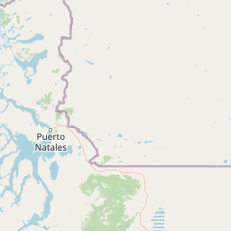
Map view of Torres del Paine National Park

Use this park location map to pinpoint Torres del Paine National Park in Chile, understand its exact geographic position, and read its mapped placement within the surrounding landscape more clearly.

Pigeon | © OpenStreetMap contributors

Location context for Torres del Paine National Park

Magallanes Region
Park atlas

Explore the geographic spread of national parks and protected areas across the Patagonian region.

Browse Other National Parks and Protected Areas Near Torres del Paine National Park
Explore nearby national parks and protected areas within the broader Patagonian region, extending your discovery beyond Torres del Paine National Park to compare diverse landscapes. Gain a deeper understanding of the geographic context and varied conservation efforts that define these iconic South American protected landscapes.
National park

Los Glaciares National Park: Argentinian National Park with Patagonian Ice Fields

Explore glacial terrain and iconic Andes peaks.

Los Glaciares National Park is a vast protected area in Argentina, dominated by a massive Patagonian ice cap and numerous descending glaciers, including the renowned Perito Moreno Glacier. Its dramatic landscape of ice fields, glacial lakes, and towering granite spires like Mount Fitz Roy provides critical context for understanding regional geography and the formation of glacial terrain. This park exemplifies the unique protected ecosystems of the southern Andes, offering rich detail for atlas-based discovery.

Area
7,269.27 km²
Established
1937
IUCN
II
Visitors
688.8K annual
National parkMagallanes and Chilean Antártica Region

Kawésqar National Park: A National Park with Distinct Protected Landscape Identity

Explore the mapped geography and protected area boundaries.

Kawésqar National Park is a key national park entity situated within the Magallanes and Chilean Antártica Region, contributing to the protected landscape of southern Chile. This atlas-focused profile details the park's geographic scope and its significance as a designated protected area. It serves as an entry point for understanding the mapped terrain and regional park context, crucial for structured geographic discovery.

Area
28,425.3 km²
Established
1969
IUCN
IV
Visitors
1.7K annual
National parkAysén del General Carlos Ibáñez del Campo Region

Bernardo O'Higgins National Park: Southern Patagonian Ice Field & Glacial Terrain

Chile's largest protected area: a map of vast ice caps and fjords.

Bernardo O'Higgins National Park is a colossal protected landscape in Chile, safeguarding much of the Southern Patagonian Ice Field and its colossal glacial features like the Pío XI Glacier. Explore the dramatic terrain of towering granite peaks and intricate fjord systems that define this remote national park. This page provides essential context for understanding its geography, mapped boundaries, and significance as a vast wilderness preservation.

Area
35,259 km²
Established
1969
IUCN
II
Visitors
36K annual
National parkChile

Pali-Aike National Park: Chilean Protected Area and Landscape Atlas

Explore the geographic context and park boundaries in Chile.

Examine Pali-Aike National Park as a distinct protected landscape within Chile. This entry offers a detailed atlas perspective, focusing on its mapped boundaries, regional geographic setting, and the specific character of its natural terrain. Understand its significance as a national park and a point of interest for geographic discovery.

Area
50.3 km²
Established
1970
IUCN
II
Visitors
2.5K annual
National park

Monte León National Park: Patagonia's First Continental Marine Protected Area and Coastal Atlas

Explore its unique sandstone formations and rich marine geography.

Monte León National Park stands as a significant federal protected area along Argentina's Patagonian coast. Known for its dramatic sandstone cliffs, including the iconic Monte Cabeza de León, and extensive Magellanic penguin colonies, this park offers a unique glimpse into coastal ecosystems. Its designation as Argentina's first continental marine park highlights its importance for biodiversity and landscape conservation along the southern Argentine Sea shoreline, providing rich context for atlas exploration.

Area
621.68 km²
Established
2004
IUCN
II
Relief
Upland
National park

Perito Moreno National Park: Argentina's Expansive Patagonian Protected Landscape

Explore its mapped terrain and significant protected area geography.

Perito Moreno National Park stands as a cornerstone of Argentinian conservation, safeguarding over 126,000 hectares of striking Patagonian mountain wilderness. This national park protects a rare ecological transition zone, blending wet Andean forests with dry steppe environments across its dramatic amphitheater-like terrain and dual-watershed hydrography. Its mapped boundaries encompass significant natural geography, offering a clear atlas view of protected Patagonian landscapes.

Area
1,268.3 km²
Established
1937
IUCN
II
Relief
Mountain
National parkAysén Region

Patagonia National Park, Chile: Exploring Protected Landscape and Regional Geography

Mapped boundaries and natural terrain in Aysén Region.

Patagonia National Park, situated within the Aysén Region of Chile, serves as a significant protected area offering rich opportunities for atlas-based geographic exploration. This national park's specific landscape identity and mapped boundaries provide a clear focal point for understanding regional conservation and natural terrain. Discover the geographic context of this protected land and its place within the broader landscape of southern Chile through structured data and map exploration.

Area
3,045.28 km²
Established
2018
IUCN
II
Relief
Mountain
National park

Patagonia National Park: A National Park Protecting the Argentine Patagonian Steppe Landscape

Explore the mapped boundaries of this semi-arid grassland ecosystem.

Patagonia National Park is a protected national park in Argentina established to preserve the representative Patagonian steppe ecosystem. Covering 528.11 square kilometers, it offers a deep dive into the unique semi-arid grassland environment, known for its rolling plains and wind-shaped terrain. This park provides crucial context for understanding the broader geography of southern Argentina and the conservation of its distinctive natural landscapes.

Area
528.11 km²
Established
2015
IUCN
II
Climate
Arid

Common questions about visiting, size, designation, and location context for Torres del Paine National Park

Torres del Paine National Park FAQs for park facts, access, geography, and protected area context
Find quick answers about Torres del Paine National Park, including protected-area facts, park geography, trail and visitor context, and how the park fits into its surrounding country and regional landscape.
MoriAtlas Explorer

Continue Your Protected Areas Search Across the Global Atlas

Deepen your exploration by continuing the structured search for national parks and protected areas worldwide. Utilize the comprehensive filtering capabilities to compare different conservation landscapes and refine your understanding of global park geography. Discover more about the distribution and characteristics of protected natural areas.

Global natural geography