
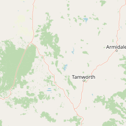
Streams
Park geography
Technical data on land area, elevation metrics, and regional natural feature associations
Towarri National Park Geographic Profile, Mapped Boundaries, and Topographic Landscape Analysis
Towarri National Park covers a recorded area of 36.39 square kilometers within the New South Wales region of Australia. This geographic profile details the park boundaries, a mean elevation of 502 meters, and identifies physical terrain features including the Liverpool Range and various creek networks.
Related tags
National ParkNew South WalesBird HabitatEndangered SpeciesTemperate Forest
Diverse upland wilderness in the Barrington Tops region of New South Wales
Towarri National Park
Towarri National Park is a protected wilderness area in the northern highlands of New South Wales, Australia, situated approximately 230 kilometres north of Sydney within the broader Barrington Tops region. The park covers an area of 36.39 square kilometres and was formally established in 1998 under the management of the National Parks and Wildlife Service of New South Wales. Characterised by undulating terrain with an average elevation of 502 metres, the park encompasses a diverse landscape of native vegetation communities, forested ridges, and open woodland habitats that support significant biodiversity. The park forms part of a larger network of protected areas in the New England Tableland region, contributing to the conservation of New South Wales highland ecosystems.
- Location
- Australia
- Park type
- National park
- Established
- 1998
- Area
- 36.4 km²
Location overview
Exploring regional jurisdiction and national placement in Australia
Geographic Setting of Towarri National Park in New South Wales
Towarri National Park is located within the state of New South Wales in Australia. Regional records establish the protected area as a non-transboundary reservation with clear administrative boundaries.
- Countries
- Australia
- Regions
- New South Wales
- Primary location
- New South Wales
Boundary and coordinates
Towarri National Park’s stored outline frames 36.39 km²
Towarri National Park mapped boundary and 36.39 km² area
Towarri National Park's stored boundary geometry situates its recorded 36.39 km² extent geographically. The measurement covers the overall area, while land and marine components and a perimeter value are unavailable.
- Boundary area
- 66.7 km²
- Boundary perimeter
- 131.7 km
- Northernmost point
- 31.8036° S
- Southernmost point
- 31.973° S
- Easternmost point
- 150.8507° E
- Westernmost point
- 150.5045° E
- Geographic centre
- 31.8625° S, 150.7388° E
- North–south span
- 18.8 km
- East–west span
- 32.8 km
Elevation and terrain
Recorded mean elevation and named natural features within the park
Towarri National Park Elevation and Terrain Geography
Towarri National Park records a mean elevation summary of 502 meters across its protected terrain. Linked natural feature cards detail specific peaks and streams located within the protected area.
- Mean elevation
- 502 m
Selected named natural features
Peaks
Rocky Downfall Mountain
Streams
Castle Gully
Streams
Wybong Creek
Streams
Ferntree Creek
Peaks
Thompsons Peak
Environmental setting
Interpreting stored landscape classifications across the protected terrain
Towarri National Park Environmental Setting and Forest Classification Records
Stored landscape classifications frame the physical environment of Towarri National Park through recorded forest categories without assuming spatial uniformity. Associated environmental records connect specific habitat attributes to broader atlas destinations.
Landscape features
Forest
Park atlas
Map the diverse protected landscapes of Australia's New England Tableland, comparing adjacent conservation areas.
Discover National Parks and Protected Areas Surrounding Towarri National Park in New South Wales
Continue your exploration of Australia's wilderness by browsing other national parks and protected areas near Towarri National Park, focusing on the broader New South Wales highland ecosystems. Compare their unique terrain, diverse vegetation communities, and conservation significance within the expansive New England Tableland region.
National parkNew South Wales
22 km away#1 closest
North

Coolah Tops National Park: Protected Landscape and Geographic Identity on the Liverpool Range
Explore New South Wales's elevated wilderness, waterfalls, and unique forests.
Coolah Tops National Park preserves a distinctive highland environment on the Liverpool Range, offering a protected wilderness experience within New South Wales. This national park is defined by its plateau landscape, featuring steep escarpments, numerous waterfalls, and dense eucalyptus forests. Its geographic position provides a striking contrast to the lower Liverpool Plains, showcasing unique flora and significant habitat for species like the greater glider, making it a vital area for regional landscape and protected-area exploration.
- Established
- 1996
- IUCN
- II
- Relief
- Upland
- Access
- Moderate access
National parkNew South Wales
42 km away#2 closest
South
Goulburn River National Park: New South Wales National Park with River Ecosystems and Heritage
Explore mapped protected lands and regional geography.
Goulburn River National Park offers a significant protected landscape within New South Wales, Australia, celebrated for its expansive Goulburn River frontage and diverse natural terrain. This national park is pivotal for understanding regional geography, featuring sandstone geological formations and serving as a critical habitat for endangered species, including the regent honeyeater. Its extensive river corridor also protects numerous Aboriginal heritage sites, contributing a rich layer of cultural significance to its conservation value. MoriAtlas helps users explore the mapped boundaries and environmental context of this vital protected area.
- Area
- 722.96 km²
- Established
- 1983
- IUCN
- II
- Relief
- Mixed relief
National parkNew South Wales
43 km away#3 closest
East
Ben Halls Gap National Park: Ancient Eucalyptus Forest Protected Landscape in New South Wales
Explore mapped boundaries of old-growth woodland terrain.
Ben Halls Gap National Park represents an ecologically vital strict nature reserve within New South Wales, Australia. It is distinguished by its extensive ancient eucalyptus forests, which are among the most ecologically significant old-growth woodland environments in eastern Australia. Managed primarily for conservation and research, the park's rugged terrain provides a critical habitat refuge and a key reference ecosystem for understanding undisturbed woodland dynamics and biodiversity.
- Area
- 30.18 km²
- Established
- 1995
- IUCN
- Ia
- Scope
- Terrestrial
National parkNew South Wales
48 km away#4 closest
East
Barrington Tops National Park: A Protected National Park in New South Wales
Explore ancient Gondwana rainforests and dramatic volcanic terrain.
Barrington Tops National Park represents a significant protected landscape in New South Wales, Australia, offering a deep dive into diverse ecosystems. Its unique altitudinal vegetation gradient supports the southernmost subtropical rainforests in Australia and showcases geological formations dating back millions of years. This park is crucial for understanding Australia's natural heritage, providing a rich context for landscape exploration and the study of ancient flora within a mapped geographic setting.
- Area
- 765.12 km²
- Established
- 1969
- IUCN
- Ib
- Relief
- Mountain
National parkNew South Wales
51 km away#5 closest
East
Mount Royal National Park: A National Park in New South Wales for Geographic Discovery
Explore its protected boundaries and landscape context.
Mount Royal National Park is a key protected area in New South Wales, offering an opportunity to delve into its specific geographic identity and mapped landscape features. As a national park, it provides structured data for understanding protected lands within Australia. This detailed entry supports exploration of the park's unique regional context and its contribution to the broader atlas of natural landscapes.
- Area
- 69 km²
- Established
- 1997
- IUCN
- II
- Relief
- Mountain
Protected areaNew South Wales
51 km away#6 closest
East
Barrington Tops State Conservation Area: Protected Plateau and Volcanic Landscape Context
Highland geography within the Mount Royal Range, New South Wales
This protected area represents a significant upland region in New South Wales, characterized by weathered plateau edges and cool mountain environments. The terrain supports high-altitude peat wetlands and diverse montane forests, rooted in the ancient geological legacy of the Barrington Volcano. Its protected boundaries link directly to the Gondwana Rainforests, providing essential habitat continuity across the Great Dividing Range.
- Area
- 84.46 km²
- Established
- 2003
- Relief
- Mountain
- Climate
- Temperate
National parkNew South Wales
53 km away#7 closest
South
Wollemi National Park: Mapping Australia's Protected Natural Landscape in New South Wales
Detailed geographic context and protected area exploration.
Wollemi National Park is a critical component of New South Wales' protected natural areas, offering rich opportunities for geographic discovery. This national park provides a distinct focus for understanding the mapped terrain and regional landscape context of Australia. Explore its position within New South Wales, uncovering the details that define its unique protected status and natural geography for dedicated atlas exploration.
- Area
- 5,017.03 km²
- Established
- 1979
- IUCN
- Ib
- Relief
- Mountain
National parkNew South Wales
66 km away#8 closest
East
Nowendoc National Park: Protected Area Identity and New South Wales Geography
Mapping the natural landscapes and protected boundaries within this national park.
Nowendoc National Park in New South Wales, Australia, offers a distinct protected landscape for atlas-driven discovery. This entry provides critical geographic context, detailing the park's mapped boundaries and its place within the regional terrain. Explore the specific identity of Nowendoc National Park as a protected natural area, crucial for understanding Australian conservation landscapes and geographic context.
- Area
- 88 km²
- Established
- 1999
- IUCN
- II
- Relief
- Upland
MoriAtlas Explorer
Continue Exploring Towarri National Park's Protected Landscape and Regional Geography
Deepen your understanding of Towarri National Park by delving into its specific geographic features and mapped protected boundaries. This exploration provides crucial context for comprehending its role within New South Wales and Australia's broader atlas of natural landscapes and conservation areas. Investigate the detailed terrain and regional distribution of this significant national park.
Browse next
Global natural geography
Explore related park routes
Explore MoriAtlas Global ParksBrowse All MoriAtlas ParksGlobal Park Map DiscoveryMoriAtlas: Browse All CountriesBrowse All MoriAtlas ContinentsNational Park Environment AtlasGrand Canyon National Park AtlasYellowstone National Park AtlasYosemite National Park Atlas and GeographySerengeti National Park AtlasGalápagos National Park Protected LandscapeBanff National Park Geography and AtlasKruger National Park Atlas EntryUluṟu-Kata Tjuṯa National Park AtlasExplore Uluru-Kata Tjuta National Park GeographyPlitvice Lakes National Park AtlasFiordland National Park Protected LandscapeGreat Smoky Mountains National Park AtlasAfghanistan National Parks and Protected AreasAlbania National Parks and Protected AreasAlgeria National Parks and Protected AreasAmerican Samoa National Parks and Protected AreasAndorra National Parks and Protected AreasAngola National Parks and Protected AreasAntarctica National Parks and Protected AreasAntigua and Barbuda Park List