Mori Atlas logo
National parkParque Nacional Tuni Condoriri

A detailed geographic look at the glacial peaks, alpine lakes, and protected high-altitude terrain

Parque Nacional Tuni Condoriri: Mapping the High Andean Landscapes of the Cordillera Real

Parque Nacional Tuni Condoriri preserves a dramatic high-altitude wilderness within the Cordillera Real, north of La Paz. This protected area features a vertical mosaic of glacial massifs, including the iconic Condoriri skyline, alongside a complex system of alpine lakes and bofedal wetlands. The terrain serves as a vital hydrological reserve for the Altiplano, showcasing the raw geological and ecological character of the Bolivian Andes through its steep cirques and meltwater basins.

Cordillera Realhigh Andean ecosystemsalpine lakesmountain peaksbofedalesglacial landscapes

Parque Nacional Tuni Condoriri

National park

Park overview

Structured park overview, official facts, and landscape profile for Parque Nacional Tuni Condoriri

Parque Nacional Tuni Condoriri park facts, protected area profile, and essential visitor context

Review the core facts for Parque Nacional Tuni Condoriri, including designation, size, terrain, visitor scale, habitats, and operating context in one park-focused overview.

About Parque Nacional Tuni Condoriri

Parque Nacional Tuni Condoriri occupies a compact but geographically rich slice of Bolivia's Cordillera Real, the eastern range of the Andes that frames the city of La Paz. Although the park covers a modest surface area, its elevation range, which spans roughly 4,500 to 6,200 meters, places it among the most vertically diverse protected landscapes in the country. Within its borders lie glacial peaks, hanging valleys, rock outcrops, and a string of clear alpine lakes, all embedded in the broader endorheic Altiplano system.

The defining geography of the park is the Condoriri group and its surrounding massifs. Nevado Condoriri forms the centerpiece, with subsidiary peaks such as Pequeño Alpamayo, Pico Austria, Ilusión, and Cabeza de Cóndor offering a wide range of climbing styles, from classic mountaineering to technical ice and mixed routes. The lower slopes and valleys are dotted with high-altitude lakes, including Tuni Condoriri, Chiar Khota, Incacatani, Eslovenia, and Ventanani, some of which receive meltwater directly from the park's snowfields and glaciers.

Ecologically, the park preserves a representative cross-section of high-Andean environments. Upper elevations are dominated by rock, ice, and rarefied vegetation, with only the hardiest plants able to survive. Mid-elevations support pajonales, vegas de ladera, and isolated shrubs of genera such as Baccharis and Werneria, alongside traditional high-Andean plants like ñapapasto, alfombrilla, maycha, paita, and rupusa. Lower slopes and lake margins give rise to the bofedales, or high-Andean peat wetlands, which play a vital role in water storage, climate regulation, and pollutant filtration.

Human activity within the park is shaped by its high-Andean setting. Llamas, alpacas, sheep, and mules are present in the area, with mules traditionally used to transport equipment for climbers and trekkers. Recreational use centers on trekking, rock and ice climbing, mountaineering, and camping, with routes that pass between summits, lakes, and small streams. The park was also created with the explicit aim of supporting high-mountain tourism, alongside the conservation of natural formations and Andean fauna. At the same time, it is currently managed as a departmental protected area under the Gobernación de La Paz rather than through the national SERNAP system.

Quick facts and research context for Parque Nacional Tuni Condoriri

Parque Nacional Tuni Condoriri is located in the Murillo province of the La Paz department in Bolivia, approximately 70 kilometers from the city of La Paz. The park was created on July 4, 1942, giving it a notably early protection date among Bolivian high-Andean reserves.

The territory lies within the Cordillera Real, also called the Cordillera de La Paz, and forms part of the endorheic basin of the Altiplano. Its roughly 92 square kilometers of landscape rise from about 4,500 to about 6,200 meters in altitude, combining glaciated summits, alpine lakes, high-Andean grasslands, and bofedal wetlands. The area is closely linked to the water supply of La Paz and El Alto and is primarily used for trekking, mountaineering, rock and ice climbing, and related alpine tourism.

Protection and recognition

Terrestrial conservation scope and documented protected area framework

Parque Nacional Tuni Condoriri Protection Status and Designated Area Record

Parque Nacional Tuni Condoriri maintains a documented terrestrial protection scope within its designated conservation framework. Structured records assemble verified management parameters and official international recognition statuses for geographic analysis.

Protection details

Protection scope
Terrestrial
Transboundary protection
No
Park context

Deeper park guide and search-rich context for Parque Nacional Tuni Condoriri

Parque Nacional Tuni Condoriri history, landscape, wildlife, and travel context

Explore Parque Nacional Tuni Condoriri through its history, landscape character, ecosystems, wildlife, conservation priorities, cultural context, and seasonal travel timing in a structured park guide built for atlas discovery and search intent.

Why Parque Nacional Tuni Condoriri stands out

Tuni Condoriri is best known for the dramatic Condoriri massif, whose layered peaks resemble an outstretched condor, and for the chain of turquoise glacial lakes tucked into the valleys below. The peaks of Pequeño Alpamayo, Pico Austria, and Nevado Condoriri have given the park an international reputation among mountaineers and ice climbers, while the surrounding high-Andean lakes, bofedales, and grasslands represent a classic example of Bolivian high-Andean ecosystems. Beyond alpinism, the park is recognized for its role in the hydrology of the La Paz region, since the glaciers and lakes around Tuni Condoriri contribute to the water supply of two of Bolivia's largest urban areas.
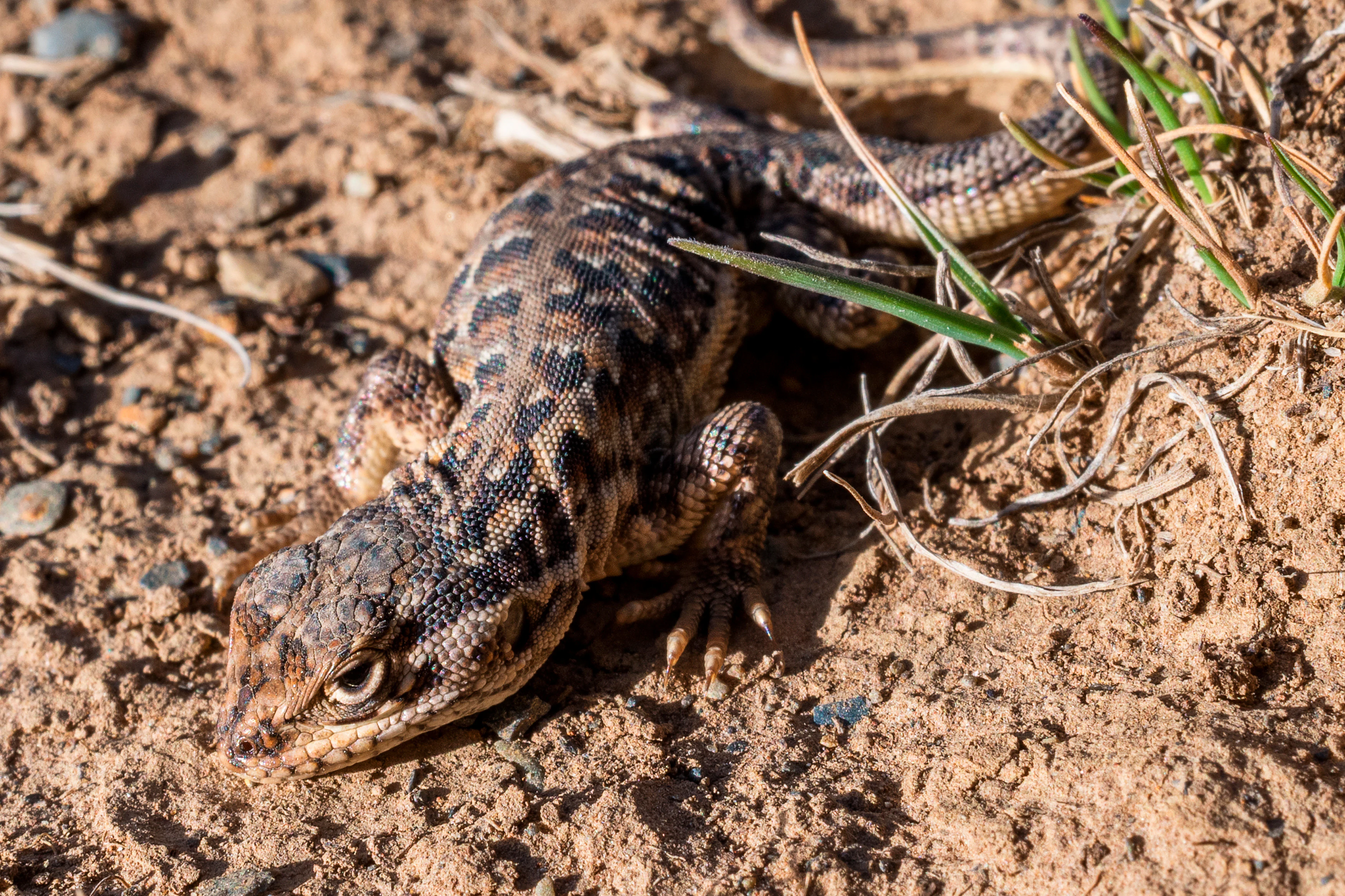
A small, patterned lizard with brown and black scales sits on dry, sandy ground with sparse grass.
A lizard rests on the dry, rocky terrain typical of the Andean landscape within Tuni Condoriri National Park.

Parque Nacional Tuni Condoriri history and protected-area timeline

Parque Nacional Tuni Condoriri was formally established on July 4, 1942, making it one of the earlier protected landscapes in Bolivia's Andean territory. Its creation reflected a mid-twentieth-century push to safeguard distinctive high-mountain formations, preserve high-Andean fauna, and open space for the development of high-altitude tourism.

Over the decades following its establishment, the park became a foundation of Bolivia's mountaineering tradition. Climbers visiting La Paz were drawn to the Condoriri massif and the surrounding peaks, particularly Pequeño Alpamayo and Pico Austria, which became training grounds for expeditions into larger Andean ranges. The park's network of glacial lakes and valleys also served as a research and outdoor recreation area for Bolivian and international visitors.

In more recent years, the park's administrative status has shifted. While it remains a designated protected area, it is currently organized under the Gobernación de La Paz as a departmental reserve rather than being formally incorporated into Bolivia's national system of protected areas, SERNAP. There is no active institutional management presence described in current sources, leaving much of the daily use and stewardship in the hands of visitors, climbers, local herders, and informal community arrangements. Conservation challenges, particularly mining and aggregate extraction in the lagoons' high basins, have added pressure on the park's ecological and hydrological functions.

Parque Nacional Tuni Condoriri landscape and geographic character

The landscape of Tuni Condoriri is a textbook example of high-Andean topography from the Cordillera Real. The park's relief was profoundly shaped by Quaternary glaciations and by ongoing glacial processes, producing a terrain of carved cirques, steep slopes, exposed bedrock, and softened valley floors. Elevations range from roughly 4,500 to about 6,200 meters, with the highest sector concentrated around Nevado Condoriri and its neighboring peaks.

The most visually striking element is the Condoriri massif itself, whose serrated skyline has been compared to the silhouette of an Andean condor with outstretched wings. Around it rise individual summits frequently named and climbed today: Pequeño Alpamayo, known for its elegant ice faces, Pico Austria, a popular training peak, Ilusión, and Cabeza de Cóndor. Glaciers and snowfields cling to the upper flanks, feeding a network of streams and high lakes lower in the valleys.

The lower elevations are defined by a chain of glacial and meltwater lakes, including Tuni Condoriri, Chiar Khota, Incacatani, Eslovenia, and Ventanani, with additional smaller unnamed pools scattered across the basin. Some lakes receive water directly from glacier melt and are tied into the broader endorheic system of the Altiplano. Around the lakes and along the gentler slopes, bofedal wetlands and high-Andean vegetation create softer, greener zones that contrast with the bare rock and ice above. Together, these features form a layered Andean scenery of rock, water, and grassland that defines the park's geographic identity.

Parque Nacional Tuni Condoriri ecosystems, habitats, and plant life

The ecosystems of Tuni Condoriri are characteristic of the upper levels of the tropical Andes, where elevation, cold temperatures, intense solar radiation, and thin soils combine to limit biological productivity. Within the park's vertical range, three broad ecological zones can be distinguished: the nival and glacial zone at the highest elevations, the high-Andean grassland and cushion-plant zone on the middle slopes, and the wetland-influenced zone in the valleys and around the lakes.

In the upper elevations, vegetation is sparse or entirely absent, with permanent snow, ice, and exposed rock dominating the landscape. As elevation decreases, features such as pajonales, vegas de ladera, and patchy grasslands take over, accompanied by isolated shrubs and cushion plants. Local names like ñapapasto, alfombrilla, maycha, paita, rupusa, thurpay, and cuncuna or julla describe plants well adapted to the harsh conditions, while shrubs of genera such as Baccharis and Werneria appear in some lower sectors. A small reforestation effort along roughly a kilometer of approach road has introduced native species such as kiswara.

A defining ecological feature of the park is the presence of bofedales, or high-Andean peat wetlands, and other smaller wetlands scattered around the lakes and streams. These wetlands store water, regulate local climate, retain sediment and contaminants, and provide habitat for a wide range of organisms, including aquatic invertebrates, plants, and waterbirds. The hydrological role of the area is amplified by its connection to the water supply of La Paz and El Alto, meaning that ecological changes within the park have direct consequences for urban water security.

Parque Nacional Tuni Condoriri wildlife and species highlights

Wildlife in Tuni Condoriri reflects the adapted fauna of the Bolivian high Andes, where most species have evolved to cope with low oxygen, extreme cold, and limited vegetation. Mammals include the Andean deer, primarily observed in the lower altitude areas of the northeastern sector of the park, along with foxes that roam the open terrain and viscachas, the small rabbit-like rodents commonly seen among the rocks.

The birdlife is particularly varied for an alpine environment. The Andean condor soars above the ridges and cliffs of the Cordillera Real, while hummingbirds are frequently observed lower down among the flowering shrubs. Waterbirds associated with the lakes and bofedales include the Andean gull, or gaviota andina, ducks of the genus Anas, herons, huallatas, and leque leques. Aquatic life in the lagoons includes native fish and mollusks, with trout noted as present in at least some of the water bodies.

Beyond these groups, insects and caterpillars contribute to the ecological network of the park, particularly around the wetlands and flowering zones. The presence of livestock such as llamas, alpacas, sheep, and mules adds an additional domestic presence, with mules traditionally playing a key logistical role by carrying equipment to base camp areas for climbers and trekkers exploring the park's peaks and lakes.

Parque Nacional Tuni Condoriri conservation status and protection priorities

The conservation value of Parque Nacional Tuni Condoriri lies in its protection of representative high-Andean ecosystems and in its role as a strategic hydrological site for one of Bolivia's most populated urban regions. Its elevation range captures fragile glacial and periglacial environments, high-Andean grasslands, and bofedales that are difficult to replace once degraded. The bofedales in particular provide climate regulation, pollutant filtration, and water storage functions that benefit both local ecosystems and downstream urban areas.

However, the park faces significant conservation pressures. Mining and aggregate extraction activities in the basins of some lakes and snowfields have been identified as threats to the area's ecosystems and water resources, with potential effects on the lakes themselves, the wetlands, and the broader hydrological network that connects the park to La Paz and El Alto. The fragility of high-Andean environments means that such disturbances can be slow to recover and may cascade through multiple ecological functions.

The institutional context adds a further layer of complexity to conservation in the park. While the area retains its protected-area designation, it currently operates under the Gobernación de La Paz as a departmental protected area and is not formally incorporated into the national SERNAP system. The absence of an active management structure means that enforcement of conservation measures and long-term ecological monitoring depend largely on coordination among regional authorities, local communities, and the users of the park.

Parque Nacional Tuni Condoriri cultural meaning and human context

Cultural context in Tuni Condoriri is shaped primarily by the high-Andean ways of life adapted to life above 4,000 meters. The presence of llamas, alpacas, sheep, and mules in the park reflects the continuation of pastoral activities that have historically sustained communities across the Bolivian Altiplano and Cordillera Real. Mules in particular have served as essential pack animals, hauling equipment for climbers, trekkers, and expeditions into the more remote valleys.

The naming convention of the park, combining the lake name Tuni with the iconic Condoriri massif, ties it to broader Andean geographic identity in which features of the landscape are named after animals, water bodies, and local traditions. Terms like ñapapasto, alfombrilla, maycha, paita, and rupusa for native plants also embed the area in a regional ethnobotanical vocabulary. While the park's formal management belongs to the Gobernación de La Paz, much of the day-to-day presence in the area continues to be shaped by mountaineers, trekking communities, and the high-Andean herding traditions associated with the surrounding cordillera.

Top sights and standout views in Parque Nacional Tuni Condoriri

Parque Nacional Tuni Condoriri stands out for the combination of an iconic mountaineering skyline, a chain of glacial lakes, and a strategic hydrological position feeding La Paz and El Alto. The Condoriri massif, with its associated peaks such as Pequeño Alpamayo and Pico Austria, is the park's most recognizable feature and one of the most climbed massifs in Bolivia.

Equally distinctive are the park's bofedales and wetlands, which provide habitat for Andean waterbirds and act as natural regulators of climate, water quality, and storage. Layered into a single protected area, these peaks, lakes, wetlands, and high-Andean grasslands make Tuni Condoriri a compact but unusually representative example of the Cordillera Real's natural heritage.

Best time to visit Parque Nacional Tuni Condoriri

Visits to Tuni Condoriri are best planned around the dry season in the Bolivian Andes, generally from May to September, when the weather is more stable, precipitation is reduced, and trails, lakes, and climbing routes around the peaks are more accessible. During these months, conditions are typically clearer for mountaineering objectives on Nevado Condoriri, Pequeño Alpamayo, and Pico Austria, and the surrounding lakes and valleys are at their most vivid.

The wet season, roughly from November to March, brings heavier precipitation, cloudier skies, and softer ground, which can limit visibility, complicate climbing conditions, and make some trails more demanding. Even outside the dry months, the park's high elevation means that conditions can shift quickly, and visitors should generally expect cool to cold temperatures, strong solar radiation by day, and freezing nights throughout the year.
Monthly climate preview

Long-term representative temperature ranges and monthly precipitation patterns for Parque Nacional Tuni Condoriri

Parque Nacional Tuni Condoriri Climate Normals and Annual Weather Rhythm

Historical data records mean temperatures ranging from five to nine degrees Celsius alongside shifting monthly precipitation across the coordinate sample. Detailed month-by-month analysis reveals the complete annual climate cycle and long-term averages for Parque Nacional Tuni Condoriri.
Annual mean8 °C
5 °C9 °C
Jan
Feb
Mar
Apr
May
Jun
Jul
Aug
Sep
Oct
Nov
Dec
Warmest month
November

9.2 °C

Coolest month
July

5 °C

Wettest month
January

4.3 mm/day

Driest month
June

0.3 mm/day

Park location guide

Geography guide, regional context, and park location map for Parque Nacional Tuni Condoriri

Parque Nacional Tuni Condoriri park geography, regions, and map view in Bolivia

Understand where Parque Nacional Tuni Condoriri sits in Bolivia through a broader geographic reading of the surrounding landscape, nearby location context, and its mapped position within the national park landscape.

How Parque Nacional Tuni Condoriri fits into Bolivia

Bolivia, officially the Plurinational State of Bolivia, is a landlocked country in central South America. It features diverse geography including the Andean mountain range, Amazonian plains, Gran Chaco, and the Pantanal wetland. The country has a population of approximately 11.4 million and is administratively divided into nine departments, with La Paz as the seat of government and Sucre as the constitutional capital.

Wider geography shaping Parque Nacional Tuni Condoriri in Bolivia

Bolivia is located in central South America, bordered by Brazil to the north and east, Paraguay to the southeast, Argentina to the south, Chile to the southwest, and Peru to the west. The country is divided between a western Andean region and tropical lowlands to the east and north. It includes the Amazonian plain, Gran Chaco, temperate valleys, the high-altitude Altiplano plateau, and part of the Pantanal wetland along its eastern border.

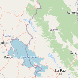
Map view of Parque Nacional Tuni Condoriri

Use this park location map to pinpoint Parque Nacional Tuni Condoriri in Bolivia, understand its exact geographic position, and read its mapped placement within the surrounding landscape more clearly.

Pigeon | © OpenStreetMap contributors

Location context for Parque Nacional Tuni Condoriri

La Paz

Visual reference guide to high mountain peaks, glacial lakes, and alpine terrain

Parque Nacional Tuni Condoriri Photos and Landscapes of the Cordillera Real

Visual documentation captures the dramatic terrain of the Condoriri massif, revealing jagged glacial peaks and alpine lakes set within high Andean wetlands. Studying protected area imagery provides a clear perspective on the rugged topography and fragile ecosystems defining this mountain sanctuary.

A small, patterned lizard with brown and black scales sits on dry, sandy ground with sparse grass.

A rocky base camp area with a small stone structure and a blue tent near a glacial lake, set against a backdrop of snow-capped mountains in the Cordillera Real.

Park atlas

Compare adjacent Andean protected areas, glacial peaks, and high-altitude reserves.

Parks Near Parque Nacional Tuni Condoriri and Surrounding Cordillera Real Landscapes

Browsing other protected areas near Parque Nacional Tuni Condoriri reveals broader regional geography across the Cordillera Real. Comparing adjacent high-mountain reserves expands the understanding of Andean ecosystems, glacial topography, and regional conservation networks.
National parkLa Paz Department
About 18 km away#1 closest

East

Cotapata National Park and Integrated Management Natural Area: A Protected Landscape in La Paz Department, Bolivia

Explore its mapped boundaries and regional geographic context.

Delve into the protected landscape identity of Cotapata National Park and Integrated Management Natural Area, situated within the La Paz Department of Bolivia. This entry provides essential geographic context, focusing on its mapped protected area status and its contribution to the regional landscape, ideal for atlas-based exploration and understanding Bolivia's conservation network.

Area
600 km²
Established
1993
IUCN
II
Scope
Terrestrial
National parkLa Paz Department
About 117 km away#2 closest

North

Madidi National Park: National Park Protected Landscape and Geographic Atlas Entry

Explore mapped boundaries and regional context in La Paz Department.

Madidi National Park is a designated national park situated in Bolivia's La Paz Department. This detail entry offers a focused perspective on its protected landscape, its specific geographic setting, and its role within the larger atlas of natural areas. Understand the park's mapped boundaries and its contribution to the regional geography, providing a foundation for structured discovery of Bolivia's protected lands.

Area
18,957.5 km²
Established
1995
IUCN
II
Relief
Mixed relief
A panoramic watercolor illustration of a mountain landscape with rolling green hills, pink distant peaks, and small green bushes in the foreground.
Protected areaBolivia
About 157 km away#3 closest

Northwest

Área Natural de Manejo Integrado Apolobamba: Protected Landscape Geography and Andean Terrain

High-altitude glacial geography and Andean-Amazonian transition zones

Located in the department of La Paz, this protected area features a rugged landscape defined by tectonic uplift and Quaternary glaciation. It safeguards critical high-Andean habitats, including peatlands and Polylepis woodlands, while providing a essential refuge for vicuña populations within its steeply dissected mountain topography.

Area
4,837.43 km²
Established
1972
Relief
Mountain
Climate
Alpine
A pale, soft-toned watercolor illustration of a calm river landscape with rolling hills in the background and sparse trees along the banks.
Biosphere reserveBolivia
About 175 km away#4 closest

Northeast

Reserva de la Biosfera y Tierra Comunitaria de Origen Pilón Lajas Protected Landscape Atlas

Mapping the Andean Amazonian transition in northern Bolivia

Spanning from high mountain ridges to the river plains of the Beni, this protected area features a unique vertical gradient of ecosystems including cloud forests and terra firme. It represents a significant model for indigenous co governance and biodiversity protection within the broader Andean and Amazonian geographic context.

Area
4,000 km²
Established
1992
Relief
Mountain
Climate
Tropical
Watercolor illustration showing a mountain range with green fields, a river, and soft pastel colors
National parkCochabamba Department
About 186 km away#5 closest

Southeast

Tunari National Park: Protected Landscape Atlas and Geographic Context

Mapped boundaries within Cochabamba Department's geography.

Tunari National Park represents a vital protected landscape within the Cochabamba Department of Bolivia. This page offers an atlas-centric exploration of the park's geographic boundaries, its relationship to the surrounding regional terrain, and its significance as a national park. Delve into the mapped context of Tunari National Park to understand its protected area status and its contribution to Bolivia's diverse geography.

Area
3,090 km²
Established
1992
IUCN
II
Relief
Mountain
National parkBolivia
About 201 km away#6 closest

South

Sajama National Park National Park: Bolivia's Mapped Protected Landscape for Geographic Exploration

Discover regional geography and mapped protected area context.

Sajama National Park represents a crucial protected area within the geography of Bolivia. This MoriAtlas entry focuses on its identity as a national park, detailing its mapped boundaries and its contribution to the regional atlas of protected lands. Understand the park's landscape context and its significance for geographic discovery within South America's diverse terrains.

Area
1,002 km²
Established
1939
IUCN
II
Relief
Mountain
National parkArica-Parinacota Region
About 229 km away#7 closest

Southwest

Lauca National Park: Mapped Volcanic Terrain and High-Altitude Protected Landscapes

Explore the geography of this Arica-Parinacota Region national park.

Lauca National Park is a significant protected area in Chile's Arica-Parinacota Region, offering a unique glimpse into the dramatic geography of the high Andes. Its landscape is characterized by imposing volcanic formations, including Parinacota Volcano, and expansive altiplano terrain. This national park serves as a vital protected landscape, inviting detailed exploration of its mapped boundaries, diverse ecosystems, and remarkable natural features for those interested in geographic context and conservation.

Area
1,379 km²
Established
1970
IUCN
II
Visitors
12.1K annual
National parkBolivia
About 235 km away#8 closest

East

Isiboro Sécure National Park and Indigenous Territory: Bolivian Protected National Park Atlas

Mapped protected boundaries and regional landscape context.

Investigate Isiboro Sécure National Park and Indigenous Territory as a key protected national park within Bolivia's expansive geography. This resource offers detailed views of its mapped natural landscape and its regional significance as a protected area. Understand the park's geographic attributes and its contribution to the country's conservation atlas through structured map-based exploration.

Area
13,721.8 km²
Established
1965
IUCN
II
Relief
Mixed relief

Common questions about visiting, size, designation, and location context for Parque Nacional Tuni Condoriri

Parque Nacional Tuni Condoriri FAQs for park facts, access, geography, and protected area context

Find quick answers about Parque Nacional Tuni Condoriri, including protected-area facts, park geography, trail and visitor context, and how the park fits into its surrounding country and regional landscape.
MoriAtlas Explorer

Continue Your Protected Areas Search Across the Global Atlas

Deepen your exploration by continuing the structured search for national parks and protected areas worldwide. Utilize the comprehensive filtering capabilities to compare different conservation landscapes and refine your understanding of global park geography. Discover more about the distribution and characteristics of protected natural areas.

Global natural geography