

Mori Atlas logo
Protected areaUchhali Complex

A geographic look at the distinctive saline lake systems and marsh landscapes of central Punjab

Uchhali Complex Protected Area: Exploring the Saline Wetlands of the Soon Valley and Salt Range

The Uchhali Complex represents a vital wetland network situated within the floor of the Soon Valley in Khushab District. This protected area includes the interconnected Khabikki, Uchhali, and Jahlar lakes, which are set against the dramatic, mineral-rich ridges of the Salt Range. Our atlas perspective focuses on the hydrological and geological conditions that support this saline ecosystem, providing a clear view of its boundaries and terrain within the regional geography of Punjab.

wetlandRamsar sitesaline lakebrackish lakemigratory birdswaterbird refuge
A stylized illustration of a mountain valley featuring multiple waterfalls cascading down rocky cliffs into a winding river, surrounded by green pine forests under a cloudy sky.

Uchhali Complex

Protected area

Park overview

Structured park overview, official facts, and landscape profile for Uchhali Complex

Uchhali Complex park facts, protected area profile, and essential visitor context

Review the core facts for Uchhali Complex, including designation, size, terrain, visitor scale, habitats, and operating context in one park-focused overview.

About Uchhali Complex

Uchhali Complex is a protected wetland system in central Punjab, Pakistan, formed by three interconnected lakes lying within the Soon Valley of the Salt Range. Khushab District, where the complex is located, is characterized by an arid interior climate, hilly terrain, and salt-bearing geology that gives the region its name. The wetland sits as a green and watery exception in this landscape, a place where seasonal inflow and rising groundwater maintain open water in an otherwise dry environment.

The three lakes that make up the complex, Khabikki Lake, Uchhali Lake, and Jahlar Lake, vary in size and salinity but share a common hydrological and ecological character. Their waters range from brackish to strongly saline, reflecting the influence of the surrounding Salt Range geology. The reedbeds, shallow margins, and open water surfaces together create a mosaic of habitats that supports both resident waterbirds and seasonal migrants traveling along broader Central Asian flyways.

As a designated Ramsar site, Uchhali Complex holds recognized international value for wetland conservation. Its designation reflects the importance of saline and brackish lake ecosystems in arid regions, which are increasingly rare and vulnerable. Beyond its formal conservation status, the wetland plays a role in regional identity and ecological education, sitting in a valley long associated with pastoral life, seasonal migrations, and traditional land use.

The broader significance of the Uchhali Complex lies in the way it combines scenic, hydrological, and ecological value in a single site. The lakes draw birdwatchers and naturalists, anchor local understanding of the Soon Valley's natural heritage, and act as a reference point for wetland management policy in Pakistan. Their continued health is closely tied to water availability, grazing pressure, and the protection of the surrounding catchment in the Salt Range.

Quick facts and research context for Uchhali Complex

The Uchhali Complex sits in the Soon Valley of the Salt Range, in Khushab District of Punjab, Pakistan. It is a Ramsar-designated wetland comprising three brackish and saline lakes, Khabikki, Uchhali, and Jahlar, that together cover around 1,243 hectares. The Ramsar designation was granted on 22 March 1996, recognizing the site as a wetland of international importance.

The complex functions as a winter refuge for migratory waterfowl and a resident habitat for several globally threatened species. It also represents a meeting point between the hydrology of the Salt Range and the arid landscapes that stretch through much of central Punjab, making it ecologically distinctive within Pakistan.

Protection and recognition

Documented terrestrial protection history and international designation records

Uchhali Complex Protection Status And International Ramsar Recognition

Terrestrial protection status for Uchhali Complex dates to 1996 with documented Ramsar site recognition. Official designation records detail international conservation status and management scope.

International recognition

Protection details

Protection scope
Terrestrial
Designated year
1996
Transboundary protection
No
Park context

Deeper park guide and search-rich context for Uchhali Complex

Uchhali Complex history, landscape, wildlife, and travel context

Explore Uchhali Complex through its history, landscape character, ecosystems, wildlife, conservation priorities, cultural context, and seasonal travel timing in a structured park guide built for atlas discovery and search intent.

Why Uchhali Complex stands out

The Uchhali Complex is best known as the most important site in Pakistan for the wintering population of the globally threatened White-headed duck. The lakes also support significant numbers of other migratory and globally rare bird species, giving the wetland a strong conservation identity that extends well beyond the country. Equally distinctive is its physical setting. The three lakes lie along the floor of the Soon Valley, framed by the rugged, mineral-rich slopes of the Salt Range. The brackish and saline chemistry of the lakes, shaped by the surrounding salt geology, distinguishes the complex from typical freshwater floodplain wetlands elsewhere in Punjab and makes it a singular component of Pakistan's protected natural areas.
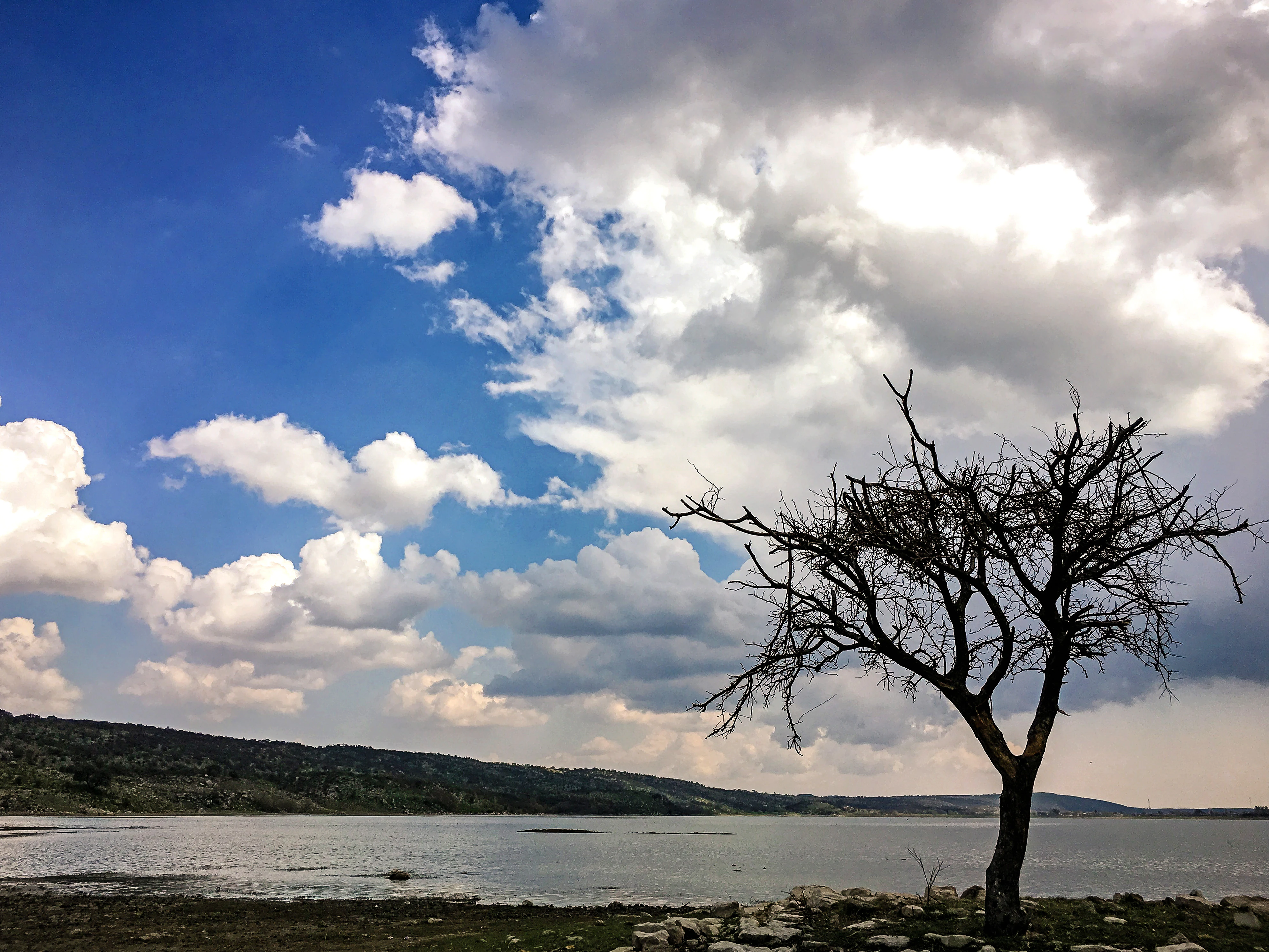
A landscape view of Khabeki Lake featuring a large bare tree on the right foreground, calm water, distant hills, and a blue sky filled with dramatic white and grey clouds.
Dramatic clouds over Khabeki Lake with a lone bare tree in the foreground.

Uchhali Complex history and protected-area timeline

The Uchhali Complex gained formal international recognition in 1996, when it was designated a Ramsar site, a designation reserved for wetlands of global ecological importance. The Ramsar listing gave the three lakes a protected status that acknowledged their importance for migratory waterbirds and rare species, particularly the White-headed duck.

Beyond its formal designation, the wetland's history is tied closely to the broader use and ecology of the Soon Valley. The valley has long hosted seasonal pastoral activity and small-scale agriculture, with the lakes serving as perennial water sources in a semi-arid setting. Over time, the ecological value of the lakes came to be recognized by national and international conservation bodies, culuming in the 1996 Ramsar listing that remains the defining milestone in the site's modern conservation history.

Uchhali Complex landscape and geographic character

The Uchhali Complex occupies the floor of the Soon Valley, a broad depression within the Salt Range of central Punjab. The Salt Range itself is a dramatic geological belt of ridges, cliffs, and eroded slopes, characterized by exposed layer of rock salt, limestone, and other sedimentary formations. This rugged backdrop frames the lakes and defines the climatic and hydrological environment in which they sit.

The wetland itself is a low-lying expanse where shallow water stands against gently sloping margins. The three lakes, Uchhali, Khabikki, and Jahlar, differ in shape and size, with Uchhali typically the largest. Their waters are brackish to saline, a condition shaped by the salt-rich geology of the surrounding hills and by evaporation in the dry climate. Reeds and emergent vegetation line sections of the shore, while other stretches give way to bare saline flats.

The landscape around the wetland shifts between cultivated fields, scattered scrub, and the rocky edges of the Salt Range. In the dry season the broader valley takes on a parched, pale character, while the lakes themselves retain water and color, creating a strong visual contrast. This combination of saline lakebeds, surrounding steppe, and rocky hills is one of the defining scenic features of the site.
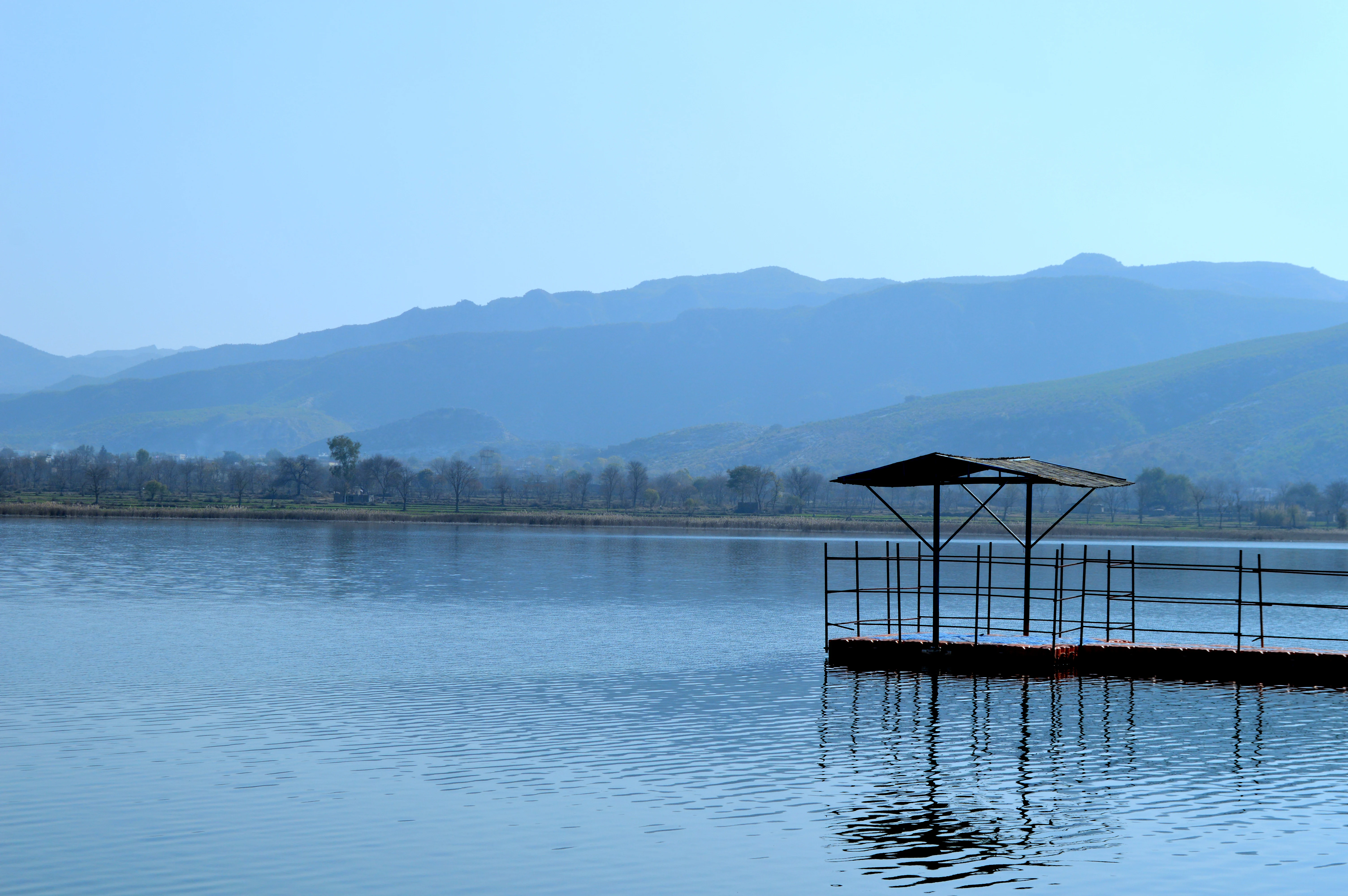
A calm lake with a small wooden pier featuring a roofed shelter, set against a backdrop of distant mountains and trees under a clear blue sky.
A view of Uchali Lake with a small wooden pier and distant mountains.

Uchhali Complex ecosystems, habitats, and plant life

Ecologically, the Uchhali Complex represents a saline wetland embedded in a semi-arid mountain setting, a combination that is unusual in Pakistan. The lakes' brackish and saline chemistry supports a distinctive set of aquatic plants and invertebrates, while the surrounding reedbeds and wet margins offer cover and feeding grounds for waterbirds. The interface between water and dry land is unusually sharp here, and that transition zone is one of the most biologically active parts of the site.

Vegetation patterns around the lakes reflect both water availability and salinity. Reeds, sedges, and salt-tolerant grasses dominate the wetter margins, while more drought-resistant scrub and grasses cover the surrounding slopes and flats. This range of microhabitats allows different ecological communities to coexist in close proximity, increasing the overall biodiversity of the complex.

The wetland's ecological role extends beyond the lake margins. The lakes help regulate local hydrology by storing seasonal runoff, and the surrounding vegetation acts as a buffer against erosion in a landscape where rainfall can be intense but brief. In this sense, the Uchhali Complex functions as both a wildlife refuge and a structural component of the Soon Valley's natural systems.

Uchhali Complex wildlife and species highlights

The Uchhali Complex is recognized above all for its birdlife, particularly its importance for migratory and globally threatened species. It stands as the most significant site in Pakistan for the wintering population of the White-headed duck, a species of high conservation concern whose presence here gives the wetland a special place in the country's natural heritage. The lakes also provide habitat for the cinereous vulture, the eastern imperial eagle, and the sociable lapwing, all species of conservation significance.

Beyond these signature species, the wetlands attract a wide variety of migratory waterbirds during the winter months. Greater flamingos appear on the saline flats, where their feeding habits match the chemistry of the lakes, while pied harriers hunt over the reedbeds and surrounding steppe. Greylag geese and ferruginous ducks form part of the wintering waterfowl community, alongside many other waterbird species that use the lakes as resting and feeding grounds.

The combination of resident and migratory species gives the lakes a changing character through the year. In winter, the open water and margins fill with flocks, while in other seasons the site supports breeding species and local wildlife. This seasonal turnover is a defining feature of the wetland and one of the reasons it has earned international recognition.

Uchhali Complex conservation status and protection priorities

Conservation significance is central to the identity of the Uchhali Complex. Its designation as a Ramsar site in 1996 placed it within a global network of wetlands recognized for their ecological value, and that status continues to anchor efforts to manage the lakes and their surroundings. The site's importance for the White-headed duck, a globally threatened species, gives the complex a particular role in international waterbird conservation.

The wetland's value is heightened by its setting. Saline and brackish lakes in semi-arid landscapes are uncommon and increasingly vulnerable to climate pressures, water extraction, and land-use change. Protecting the Uchhali Complex therefore contributes to the conservation of a rare ecosystem type, not just a single species or habitat patch.

Management of the site revolves around maintaining water levels, controlling grazing pressure, and preventing disturbance to waterbirds. Its Ramsar status also raises the profile of the Soon Valley's ecological resources more broadly, supporting the idea that the valley's natural heritage extends beyond any single lake or species.

Uchhali Complex cultural meaning and human context

The Uchhali Complex sits in the Soon Valley, a region with a long history of pastoral and agricultural land use. Local communities have traditionally depended on the valley's water sources, including the lakes, for livestock and limited cultivation. The presence of perennial water in an otherwise dry environment has shaped settlement patterns and seasonal movement in the area.

The Salt Range itself carries deep geological and cultural significance in Pakistan, with features such as the centuries-old Khewra Salt Mine located within the same broader landscape. This regional identity, rooted in the mixture of rugged geology and scattered pockets of fertility, gives the Uchhali Complex a cultural context that extends beyond its formal ecological value.

Top sights and standout views in Uchhali Complex

The Uchhali Complex's strongest points of distinction are its role as Pakistan's foremost wintering site for the White-headed duck, its three-lake structure within the dramatic Salt Range, and its Ramsar-listed status. Its saline lake chemistry sets it apart from freshwater wetlands elsewhere in Punjab, and its position in the Soon Valley gives it a scenic setting defined by rugged ridges and open valley floors.

The wetland also stands out for the diversity of conservation-relevant birds it supports, from greater flamingos on saline flats to cinereous vultures and eastern imperial eagles in the surrounding hills. Together these qualities make the complex a landmark site for understanding saline wetland ecology and waterbird conservation in arid South Asia.

Best time to visit Uchhali Complex

Winter is the most ecologically meaningful time to experience the Uchhali Complex, because this is when migratory waterfowl arrive in their largest numbers. The lakes fill with flocks of ducks, geese, flamingos, and other waterbirds, including the globally rare White-headed duck. Cooler temperatures also make exploring the valley more comfortable and improve visibility across the open water and surrounding slopes.

Outside of winter, the wetland has a quieter atmosphere. Spring and early summer bring breeding activity among resident species, while later in the dry season the lakes shrink slightly and the surrounding landscape takes on a harsher, more arid character. Each season offers a different reading of the site, but winter remains the focal period for both birdwatching and ecological observation.
Monthly climate preview

Long-term representative monthly averages and temperature ranges for Uchhali Complex

Uchhali Complex Climate Normals, Annual Temperature and Precipitation Rhythm

Uchhali Complex displays a recorded annual temperature rhythm spanning mean values from 11.14 degrees Celsius to 35.61 degrees Celsius alongside varying monthly precipitation rates. Reviewing the complete twelve-month climatology provides deeper insight into the measured temperature extremes and precipitation patterns across this protected area.
Annual mean24 °C
11 °C36 °C
Jan11°
Feb14°
Mar19°
Apr26°
May32°
Jun36°
Jul35°
Aug33°
Sep30°
Oct25°
Nov18°
Dec14°
Warmest month
June

35.6 °C

Coolest month
January

11.1 °C

Wettest month
July

3 mm/day

Driest month
November

0.2 mm/day

Park location guide

Geography guide, regional context, and park location map for Uchhali Complex

Uchhali Complex park geography, regions, and map view in Pakistan

Understand where Uchhali Complex sits in Pakistan through a broader geographic reading of the surrounding landscape, nearby location context, and its mapped position within the national park landscape.

How Uchhali Complex fits into Pakistan

Pakistan, officially the Islamic Republic of Pakistan, is a federal parliamentary Islamic republic in South Asia. It is the fifth-most populous country and the 33rd-largest by area. The country gained independence from British India in 1947 and has a diverse history spanning ancient civilizations including Mehrgarh and the Indus Valley Civilisation. Pakistan shares maritime borders with Oman and is bounded by the Arabian Sea, Gulf of Oman, and several neighboring countries.

Wider geography shaping Uchhali Complex in Pakistan

Pakistan is located in South Asia, bordered by the Arabian Sea to the south, the Gulf of Oman to the southwest, and shares land borders with India to the east, Afghanistan to the west, Iran to the southwest, and China to the northeast. The country also shares a maritime border with Oman in the Gulf of Oman. The Wakhan Corridor in Afghanistan separates Pakistan from Tajikistan in the northwest.

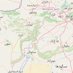
Map view of Uchhali Complex

Use this park location map to pinpoint Uchhali Complex in Pakistan, understand its exact geographic position, and read its mapped placement within the surrounding landscape more clearly.

Pigeon | © OpenStreetMap contributors

Location context for Uchhali Complex

Khushab DistrictPunjab

Visualizing saline lakes, wetland habitats, and Salt Range terrain

Uchhali Complex Photos and Landscape Scenery Exploration

Photographic collections reveal the distinctive saline lakebeds, marshy shorelines, and rugged geological framing that define the Soon Valley wetland ecosystem. Visual records provide essential context for understanding the complex topography, sparse scrub vegetation, and critical waterbird habitats protected within the region.

A landscape view of Khabeki Lake featuring a large bare tree on the right foreground, calm water, distant hills, and a blue sky filled with dramatic white and grey clouds.

Satellite view of three dark blue lakes surrounded by arid beige and green terrain in the Uchhali Wetlands Complex.

A calm lake with a small wooden pier featuring a roofed shelter, set against a backdrop of distant mountains and trees under a clear blue sky.

Park atlas

Discover related wetland reserves and regional protected natural areas across the Salt Range

Explore Parks Near Uchhali Complex and Surrounding Protected Landscapes

Compare Uchhali Complex with adjacent protected areas to examine regional wetland ecosystems and geological diversity across the surrounding region. Broaden your geographic analysis by exploring related wildlife refuges and connected natural habitats throughout central Pakistan.
Wildlife reservePunjab
About 32 km away#1 closest

East

Chumbi Surla Wildlife Sanctuary: Geographic Overview of Punjab Foothill Habitats

Mapping protected scrub forests and ridges in Khushab and Chakwal

Covering thousands of acres of contiguous reserve forest, Chumbi Surla Wildlife Sanctuary represents a crucial protected ecosystem within the Punjab landscape. This high-altitude scrub environment provides an essential refuge for the Punjab urial, characterized by deep valleys, stony slopes, and ridge systems that define the topography of the local Salt Range outliers.

Area
226.4 km²
Established
1978
IUCN
IV
Relief
Upland
National parkPunjab
About 63 km away#2 closest

Northeast

Chinji National Park: National Park Atlas, Salt Range Geography, and Protected Landscape

Discover the unique eroded terrain and semi-arid ecosystems of Punjab, Pakistan.

Chinji National Park is a protected national park located in the Punjab province of Pakistan, specifically within the historic Salt Range. This park is characterized by its deeply eroded terrain, composed of sandstone and igneous rock formations, shaped by seasonal streams that lead towards the Soan River. As a key example of a semi-arid mountain ecosystem within the Baluchistan xeric woodlands ecoregion, Chinji National Park offers significant insights into the geological heritage and unique biodiversity of central Pakistan.

Area
60.95 km²
Established
1987
IUCN
II
Relief
Upland
National parkPakistan
About 75 km away#3 closest

East

Salt Range National Park: Pakistan's Protected Landscape for Geographic Atlas Exploration

Mapped boundaries and regional terrain context for a Pakistani national park.

Gain insight into Salt Range National Park, a significant national park established within Pakistan. This entry focuses on its role as a protected landscape, providing a mapped view of its geographic scope and environmental context. Understand how this park contributes to Pakistan's broader geography and offers opportunities for atlas-based discovery of its natural terrain.

Relief
Mountain
Scope
Terrestrial
National parkJhelum District
About 110 km away#4 closest

East

Tilla Reserve National Park: Mapped Protected Landscape and Dry Forest Ecosystem

Explore the geography and ancient heritage of this Salt Range national park.

Tilla Reserve National Park is a protected area recognized for its significant dry subtropical forest ecosystems and rich cultural history within Pakistan's Salt Range. Situated in Jhelum District, the park's landscape is characterized by steep, rocky ridges and ancient geological formations. Discover its unique mapped terrain, the distribution of its remnant forest habitats, and its importance as a protected natural and spiritual site.

Area
40.6 km²
Established
2021
IUCN
II
Relief
Mountain
National parkPakistan
About 116 km away#5 closest

West

Sheikh Badin National Park: Pakistan's Sulaiman Mountains Protected Landscape Explorer

Semi-arid terrain and rich herpetofauna habitat in Khyber Pakhtunkhwa.

Investigate Sheikh Badin National Park, a key protected area situated within Pakistan's Sulaiman Mountains. This national park showcases a distinctive semi-arid mountain terrain, characterized by rocky ridges and valleys, offering insights into ecological transition zones. Delve into the park's mapped boundaries and its significance as a habitat for diverse birdlife and herpetofauna within Pakistan's geography.

Area
155.4 km²
Established
2003
IUCN
II
Relief
Mountain
Protected areaKhyber Pakhtunkhwa
About 119 km away#6 closest

Northwest

Tanda Dam Protected Area: Geographic Context and Wetland Map Features in Khyber Pakhtunkhwa

Ramsar-listed reservoir and regional irrigation landscape

Tanda Dam is a critical irrigation reservoir and Ramsar-listed wetland located in the Kohat District. This protected area supports agricultural networks for surrounding villages while serving as a winter refuge for migratory waterbirds traveling from the Caspian region and Siberia. The site offers a unique perspective on managed water landscapes within the broader terrain of Khyber Pakhtunkhwa.

Area
4.05 km²
Established
1967
Relief
Lowland
Scope
Terrestrial
National parkAttock District
About 119 km away#7 closest

North

Kala Chitta National Park: Protected Dry Temperate Forest in Attock District, Pakistan

Discover unique hill landscapes and a rare ecosystem on the Pothohar Plateau.

Kala Chitta National Park represents a crucial protected area in Punjab, Pakistan, safeguarding a distinct dry temperate forest ecosystem that is uncommon in the Pothohar Plateau's heavily agricultural landscape. The park's terrain comprises rolling hills and intervening plains, contributing to its ecological richness and providing valuable mapped landscape context. Explore the geographic importance of this national park and its role in preserving a vital natural habitat.

Area
363.77 km²
Established
1983
IUCN
II
Relief
Mixed relief
National parkPunjab
About 120 km away#8 closest

Northeast

Kheri Murat National Park: Protected Scrub Forest and Wildlife Conservation in Punjab

Explore the mapped terrain and protected landscape context.

Discover Kheri Murat National Park, a recent national park designation located in Punjab, Pakistan, situated on the rolling hills of the Kala Chitta Range. This protected area features a distinct subtropical thorn scrub forest ecosystem, providing essential habitat for wildlife, including the Punjab urial, and serving as a critical site for bird conservation. Its unique landscape offers valuable insights into regional geography and the preservation of natural wilderness within a predominantly agricultural province, making it a noteworthy entity for atlas exploration.

Area
35.37 km²
Established
2020
IUCN
II
Relief
Mountain

Common questions about visiting, size, designation, and location context for Uchhali Complex

Uchhali Complex FAQs for park facts, access, geography, and protected area context

Find quick answers about Uchhali Complex, including protected-area facts, park geography, trail and visitor context, and how the park fits into its surrounding country and regional landscape.
MoriAtlas Explorer

Continue Your Protected Areas Search Across the Global Atlas

Deepen your exploration by continuing the structured search for national parks and protected areas worldwide. Utilize the comprehensive filtering capabilities to compare different conservation landscapes and refine your understanding of global park geography. Discover more about the distribution and characteristics of protected natural areas.

Global natural geography