Mori Atlas logo
National parkVan Mijenfjorden National Park

Discover the geographic boundaries and glacial terrain of this significant Norwegian national park.

Van Mijenfjorden National Park: Mapped Arctic Fjord Protected Landscape in Svalbard

Van Mijenfjorden National Park represents a critical protected landscape within the Svalbard archipelago, showcasing a representative Arctic fjord ecosystem. As a designated national park in Norway, it safeguards the unique sub-Arctic environments, including the expansive Van Mijenfjorden and its surrounding tundra and mountainous terrain. This page serves as your atlas-level entry point to understanding the park's geographic significance, mapped boundaries, and its role in preserving Svalbard's dramatic glacial scenery and coastal ecosystems for structured discovery.

Arctic fjordsSvalbard protected areasNorwegian national parksCoastal ecosystemsGlacial landscapesSub-Arctic environments

Van Mijenfjorden National Park

National park

Park overview

Structured park overview, official facts, and landscape profile for Van Mijenfjorden National Park

Van Mijenfjorden National Park park facts, protected area profile, and essential visitor context
Review the core facts for Van Mijenfjorden National Park, including designation, size, terrain, visitor scale, habitats, and operating context in one park-focused overview.

About Van Mijenfjorden National Park

Van Mijenfjorden National Park protects a significant Arctic fjord environment in the Svalbard archipelago. The park encompasses the Van Mijenfjorden fjord, which cuts into the southern coast of Spitsbergen, creating a protected maritime landscape surrounded by mountainous terrain. This Arctic protected area represents Norway's broader conservation efforts in Svalbard, where multiple national parks and nature reserves work together to preserve the archipelago's unique sub-Arctic ecosystems. The fjord's protected status helps maintain the natural character of the coastline while preserving the ecological connections between marine and terrestrial environments that define Arctic coastal landscapes.

Quick facts and research context for Van Mijenfjorden National Park

Van Mijenfjorden is located in southern Spitsbergen, Svalbard. The fjord extends inland from the Barents Sea, surrounded by mountainous terrain and Arctic tundra landscape. As with other Svalbard protected areas, the park is characterized by Arctic climate conditions, with cold temperatures, limited vegetation, and a short growing season. The area provides habitat for various Arctic wildlife species adapted to the harsh sub-Arctic environment.

Park context

Deeper park guide and search-rich context for Van Mijenfjorden National Park

Van Mijenfjorden National Park history, landscape, wildlife, and travel context
Explore Van Mijenfjorden National Park through its history, landscape character, ecosystems, wildlife, conservation priorities, cultural context, and seasonal travel timing in a structured park guide built for atlas discovery and search intent.

Why Van Mijenfjorden National Park stands out

Van Mijenfjorden is best known as a representative Arctic fjord ecosystem within Svalbard's protected area network. The fjord itself serves as an important coastal feature, with its waters supporting marine life and its shores providing access to the surrounding tundra and mountain environments. The area exemplifies the dramatic glacial landscapes that define much of Svalbard's geography.

Wide view of a valley with a lake surrounded by rocky mountains with patches of snow under a partly cloudy sky
Panoramic view of a mountainous landscape with a lake and snow-capped peaks under partly cloudy sky

Van Mijenfjorden National Park history and protected-area timeline

The establishment of Van Mijenfjorden as a national park reflects Norway's systematic approach to protecting Svalbard's natural environments. The park was created as part of broader conservation planning for the Svalbard archipelago, which has seen the designation of multiple protected areas since the mid-20th century. The legal framework governing the park falls under Norwegian environmental legislation designed to preserve the Arctic ecosystems and landscapes that make Svalbard distinctive.

Van Mijenfjorden National Park landscape and geographic character

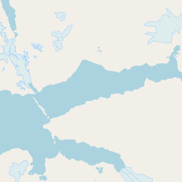
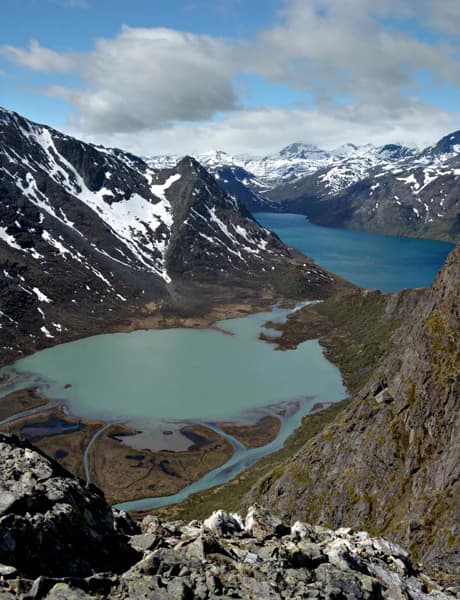
The landscape of Van Mijenfjorden National Park centers on the fjord itself, a glacial valley that extends from the Barents Sea into the mountainous interior of southern Spitsbergen. The surrounding terrain features Arctic tundra, steep mountain slopes, and the stark, treeless character typical of high-latitude environments. The fjord waters reflect the surrounding landscape, creating a dramatic interplay between sea and mountain that defines much of Svalbard's coastal scenery.

Van Mijenfjorden National Park ecosystems, habitats, and plant life

The nature of Van Mijenfjorden reflects the sub-Arctic conditions of Svalbard, with limited vegetation dominated by mosses, lichens, and hardy Arctic plants that survive the harsh climate. The marine environment of the fjord supports organisms adapted to cold Arctic waters, while the surrounding land areas provide habitat for species capable of thriving in the tundra environment. The overall ecological character represents the delicate balance of Arctic ecosystems that exist at the edge of habitable conditions.

Van Mijenfjorden National Park wildlife and species highlights

Wildlife in Van Mijenfjorden National Park includes species adapted to the Arctic environment of Svalbard. Marine mammals may be found in the fjord waters, while birdlife utilizes the coastal areas for nesting and feeding. The broader Svalbard archipelago is known for populations of seabirds, seals, and Arctic foxes, with the protected fjord providing sheltered habitat that supports these species throughout the year.

Van Mijenfjorden National Park conservation status and protection priorities

The national park status of Van Mijenfjorden contributes to Svalbard's network of protected areas that preserve the archipelago's Arctic ecosystems. Conservation efforts in the park focus on maintaining the natural state of the fjord environment and surrounding landscape, protecting the ecological processes that sustain Arctic wildlife populations. The protected area designation helps ensure that this Arctic fjord ecosystem remains intact for future generations.

Van Mijenfjorden National Park cultural meaning and human context

The cultural context of Van Mijenfjorden relates to the broader history of human activity in Svalbard. The archipelago has been used for fishing, whaling, and mining over centuries, with various cultural influences reflected in the historical sites found throughout the region. The fjord itself has served as a natural harbor and access point to the interior of Spitsbergen, connecting to the human history of exploration and resource extraction that characterizes much of Svalbard's past.

Top sights and standout views in Van Mijenfjorden National Park

Van Mijenfjorden National Park protects a representative example of Svalbard's Arctic fjord landscapes. The combination of dramatic mountain terrain, coastal waters, and tundra environments creates a protected area that exemplifies the Arctic wilderness character of the archipelago. The park contributes to Norway's commitment to preserving the unique natural values of Svalbard.

Best time to visit Van Mijenfjorden National Park

Visiting Van Mijenfjorden National Park is best during the Arctic summer months when temperatures are milder and daylight hours are extended. The summer season allows for greater opportunity to explore the outdoor environment and observe wildlife. Winter visits are possible but are limited by the harsh Arctic conditions and reduced daylight that characterize the dark season in Svalbard.

Park location guide

Geography guide, regional context, and park location map for Van Mijenfjorden National Park

Van Mijenfjorden National Park park geography, regions, and map view in Norway
Understand where Van Mijenfjorden National Park sits in Norway through a broader geographic reading of the surrounding landscape, nearby location context, and its mapped position within the national park landscape.

How Van Mijenfjorden National Park fits into Norway

Norway, officially the Kingdom of Norway, is a Nordic country in Northern Europe located on the Scandinavian Peninsula. It encompasses mainland Norway, the Arctic islands of Svalbard and Jan Mayen, and maintains dependencies including Bouvet Island and Antarctic claims. The country has a population of about 5.6 million and is bordered by Sweden, Finland, and Russia. Norway is a unitary parliamentary constitutional monarchy with Oslo as its capital and largest city.

Wider geography shaping Van Mijenfjorden National Park in Norway

Norway occupies the western and northern portions of the Scandinavian Peninsula in Northern Europe. The country shares a long eastern border with Sweden, and borders Finland and Russia to the northeast. Norway has an extensive coastline facing the Skagerrak, North Sea, Norwegian Sea, and Barents Sea. The terrain is predominantly mountainous with numerous fjords along the coastline.

Map view of Van Mijenfjorden National Park

Use this park location map to pinpoint Van Mijenfjorden National Park in Norway, understand its exact geographic position, and read its mapped placement within the surrounding landscape more clearly.

Pigeon | © OpenStreetMap contributors

Visually explore the rugged Arctic landscapes of Van Mijenfjorden National Park, tracing its glacial fjords, tundra, and coastal protected areas.

Van Mijenfjorden National Park Photos: Explore Arctic Fjord Landscapes and Svalbard Scenery
Browse these compelling images to grasp the unique Arctic character of Van Mijenfjorden National Park, revealing its dramatic glacial fjords, stark tundra, and pristine coastal ecosystems. This visual collection offers invaluable context for understanding the park's specific terrain, habitat diversity, and the distinctive protected-area environment of Svalbard.

Wide view of a valley with a lake surrounded by rocky mountains with patches of snow under a partly cloudy sky

Park atlas

Compare other protected areas, tracing Svalbard's distinctive Arctic fjord systems and expansive conservation landscapes.

Discover More Protected Areas Near Van Mijenfjorden National Park and Explore Svalbard's Arctic Landscapes
After exploring Van Mijenfjorden National Park, browse other national parks and protected areas across the Svalbard archipelago, including neighboring Arctic fjord ecosystems and glacial terrain. Compare their unique conservation profiles and mapped geography to understand the regional spread of Norway's high-latitude protected landscapes.
Watercolor illustration of a fjord with mountains, trees, and water bodies
National parkSpitsbergen

Nordre Isfjorden National Park: Arctic Coastal Protected Landscape

Discover Spitsbergen's mapped fjord geography and wildlife.

Nordre Isfjorden National Park on Spitsbergen offers a compelling view into a pristine Arctic environment. This protected national park encompasses dramatic coastal cliffs, tundra terrain, and the biologically rich waters of Isfjorden. It is renowned for supporting immense seabird colonies that rely on the nutrient-dense fjord, making it a significant site for understanding high Arctic ecosystems and marine protected areas.

Area
2,954 km²
Established
2003
IUCN
II
Relief
Lowland
National parkSvalbard

Sassen, Bünsow Land National Park: A Mapped Arctic Glacial Landscape in Svalbard

Explore protected boundaries and polar terrain.

Sassen, Bünsow Land National Park, located in the heart of Spitsbergen, Norway, showcases a quintessential Arctic wilderness defined by its expansive glacial features and deeply incised valleys. This protected area, part of the Svalbard archipelago, offers rich geographic context through its mapped terrain, highlighting glacial processes that have shaped the landscape. Discover the unique polar environment and the significance of this national park within the broader Norwegian Arctic atlas.

Area
1,230 km²
Established
2003
IUCN
II
Relief
Mountain
National park

Sør-Spitsbergen National Park: Mapping Norway's Pristine Arctic Protected Landscape

Explore glacial terrain, tundra ecosystems, and significant seabird colonies.

Delve into Sør-Spitsbergen National Park, a cornerstone of Arctic protected areas within Norway's Svalbard archipelago. This extensive national park showcases raw glacial terrain, expansive ice caps, and sparse tundra valleys, offering a unique geographic context. It is globally recognized for its vast seabird colonies, particularly the dense nesting sites of thick-billed guillemots, and Ramsar-protected wetlands. Understanding Sør-Spitsbergen National Park through its mapped boundaries and landscape features provides critical insight into Arctic conservation and natural processes.

Area
8,504 km²
Established
1973
IUCN
II
Relief
Mixed relief
National parkSvalbard

Forlandet National Park: High Arctic Protected Landscape and Global Wildlife Limits

Explore mapped geography and protected ecosystem boundaries in Svalbard.

Forlandet National Park stands as a crucial element in the Arctic atlas, safeguarding the island of Prins Karls Forland and its surrounding marine territories. As the world's most northerly national park, it showcases a unique High Arctic landscape defined by stark coastal cliffs and vital waters supporting specialized wildlife. This protected area is recognized for harboring the most extreme northern populations of seals and common guillemots, making it a significant site for understanding polar ecosystems and conservation efforts within the Svalbard region.

Area
4,647 km²
Established
1973
IUCN
II
Relief
Lowland
National park

Indre Wijdefjorden National Park: Arctic Steppe and Fjord Protected Landscape Exploration

Mapped protected boundaries and unique terrain in Svalbard.

Discover the unique High Arctic steppe and dramatic fjord landscape of Indre Wijdefjorden National Park, a protected area in Svalbard, Norway. This park safeguards a rare ecosystem with endemic plant species, offering exceptional insights into Arctic geography and protected land conservation. Explore its mapped boundaries and distinct terrain, a key destination for atlas-based landscape discovery.

Area
1,127 km²
Established
2005
IUCN
II
Relief
Mountain
National parkSvalbard

Nordvest-Spitsbergen National Park: Protected Arctic Landscape and Geographic Atlas

Explore unique hot springs, glacial terrain, and polar expedition history.

Nordvest-Spitsbergen National Park, a protected national park in Norway's Svalbard archipelago, showcases dramatic Arctic geography. This page details its mapped landscapes, from volcanic terrains and glacial valleys to its famed northernmost hot springs. Discover the park's protected area status, its role in regional geography, and its historical significance for polar exploration, providing a rich context for atlas-based exploration.

Area
9,914 km²
Established
1973
IUCN
II
Relief
Mixed relief
National parkFinnmark

Seiland National Park: Arctic Island Landscape and Northernmost Scandinavian Glaciers

Mapped boundaries of protected terrain in Finnmark

Seiland National Park offers a distinct glimpse into Arctic island geography, renowned for protecting Scandinavia's northernmost glaciers. This protected area in Finnmark features a dramatic landscape shaped by glaciated mountains, deep coastal fjords, and alpine terrain, making it a key destination for understanding Nordic natural environments. MoriAtlas facilitates exploration of its mapped boundaries and the unique combination of glacial and marine ecosystems present.

Area
316 km²
Established
2006
IUCN
II
Relief
Mountain
National park

Stabbursdalen National Park: Protected Arctic Landscape and Northernmost Pine Forest Atlas

Explore Finnmark's unique geography and protected terrain.

Stabbursdalen National Park preserves a remarkable ecological boundary, featuring the planet's northernmost Scots pine woodland within a dramatic Arctic landscape. This protected area offers a deep dive into rugged mountain terrain, river valley formations, and vital wetland habitats. As a key component of Norway's protected lands, it provides essential context for understanding regional geography and the limits of forest ecosystems on the mapped landscape.

Area
747 km²
Established
1970
IUCN
II
Relief
Mixed relief

Common questions about visiting, size, designation, and location context for Van Mijenfjorden National Park

Van Mijenfjorden National Park FAQs for park facts, access, geography, and protected area context
Find quick answers about Van Mijenfjorden National Park, including protected-area facts, park geography, trail and visitor context, and how the park fits into its surrounding country and regional landscape.
MoriAtlas Explorer

Continue Your Protected Areas Search Across the Global Atlas

Deepen your exploration by continuing the structured search for national parks and protected areas worldwide. Utilize the comprehensive filtering capabilities to compare different conservation landscapes and refine your understanding of global park geography. Discover more about the distribution and characteristics of protected natural areas.

Global natural geography