Mori Atlas logo
Nature reserveVeliko Ratno Ostrvo

Discover the unique river island geography and protected status of Veliko Ratno Ostrvo.

Veliko Ratno Ostrvo Nature Reserve: Mapped Geography and Protected Landscape Context

Veliko Ratno Ostrvo, meaning Great War Island, is a distinct nature reserve situated on a prominent Danube River island near Belgrade, Serbia. As a vital protected area within the Balkan region, this riverine landscape offers a unique geographic feature within Serbia's capital area. MoriAtlas provides a structured exploration of Veliko Ratno Ostrvo's mapped boundaries and its significance as a protected natural asset.

river islandDanubeSerbiaBalkanprotected areawetland
Stylized illustration of a winding river through a canyon with cliffs, green vegetation, and yellow flowers in the foreground

Veliko Ratno Ostrvo

Nature reserve

Park overview

Structured park overview, official facts, and landscape profile for Veliko Ratno Ostrvo

Veliko Ratno Ostrvo park facts, protected area profile, and essential visitor context
Review the core facts for Veliko Ratno Ostrvo, including designation, size, terrain, visitor scale, habitats, and operating context in one park-focused overview.

About Veliko Ratno Ostrvo

Veliko Ratno Ostrvo (translated as Great War Island) is a river island located in the Danube River near Belgrade, Serbia. This island represents a notable geographic feature within Serbia's riverine landscape and serves as a natural area within the Belgrade metropolitan region.

Quick facts and research context for Veliko Ratno Ostrvo

Veliko Ratno Ostrvo is situated in the Danube River, forming part of the Belgrade metropolitan area. The island's name translates to Great War Island in English, reflecting its historical designation. As a river island, it represents a distinct ecological and geographic feature within Serbia's landscape.

Park location guide

Geography guide, regional context, and park location map for Veliko Ratno Ostrvo

Veliko Ratno Ostrvo park geography, regions, and map view in Serbia
Understand where Veliko Ratno Ostrvo sits in Serbia through a broader geographic reading of the surrounding landscape, nearby location context, and its mapped position within the national park landscape.

How Veliko Ratno Ostrvo fits into Serbia

Serbia is a landlocked country in Southeast and Central Europe, bordered by eight neighboring countries. With a population of approximately 6.6 million, it operates as a unitary parliamentary republic with Belgrade as its capital. The country has a rich history dating back to medieval statehood in the 7th century and has been independent since 2006 following the dissolution of Serbia and Montenegro.

Wider geography shaping Veliko Ratno Ostrvo in Serbia

Serbia is a landlocked country in the Balkans, spanning parts of Southeast and Central Europe. It occupies a strategic position in the heart of the Balkan Peninsula, bordered by Hungary to the north, Romania to the northeast, Bulgaria to the southeast, North Macedonia to the south, Croatia to the northwest, Bosnia and Herzegovina to the west, and Montenegro to the southwest. The terrain varies from rolling plains in the north to mountainous regions in the south and east.

Map view of Veliko Ratno Ostrvo

Use this park location map to pinpoint Veliko Ratno Ostrvo in Serbia, understand its exact geographic position, and read its mapped placement within the surrounding landscape more clearly.

Pigeon | © OpenStreetMap contributors

Explore the diverse riverine habitats and unique terrain of Veliko Ratno Ostrvo through a detailed visual gallery

Veliko Ratno Ostrvo Park Photos: Visualizing Serbia's Danube River Island Landscape and Protected Area Scenery
Browse a comprehensive visual collection of Veliko Ratno Ostrvo, highlighting its distinct river island geography and the significant wetland ecosystems within this protected area. These images offer detailed views of the island's unique landscapes and habitats, providing essential context for understanding its conservation importance and visual character.

Panoramic view of a winding river through a green valley with rocky foreground and yellow wildflowers under a cloudy sky

Wide river with islands covered in trees, distant city skyline under clear blue sky

Squacco Heron with brown and white plumage and blue beak standing on green vegetation

Sunlight filtering through twisted tree branches with grass and tall plants in the foreground

Aerial view of two major rivers meeting in an urban area with city development visible along the riverbanks

Stone archway with metal grilles framing a view of a forested island across a river

Paved pathway leading to a pontoon bridge over water, with trees on both sides and a white signpost on the left

Cargo barge floating on a wide river with calm waters, forested shoreline and clear blue sky

Aerial view of the Sava and Danube rivers confluence near Belgrade, Serbia

Wide view of a river with a large tree-covered island in the middle, several boats on the water, and a cityscape in the distance

People swimming and relaxing on a sandy beach with boats on the Danube River, buildings visible in the background

Park atlas

Compare adjacent protected landscapes in Serbia, tracing riverine ecosystems and the regional park spread.

Explore Nearby Protected Areas and Regional Park Geography Around Veliko Ratno Ostrvo
Explore additional protected areas beyond Veliko Ratno Ostrvo, browsing other national parks and natural reserves mapped across the broader Serbian landscape. Compare diverse protected landscapes, trace interconnected riverine ecosystems, and understand regional conservation efforts within a cohesive geographic context.
Watercolor painting of a landscape featuring rolling hills, a lake, trees, and a sky with clouds
Natural monument

Avala Natural Monument: Iconic Protected Landscape and Regional Geography Near Belgrade

Explore Avala's mapped terrain and natural monument significance.

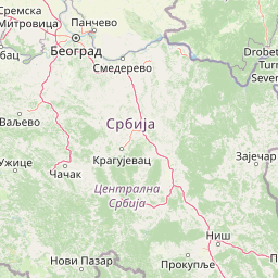
Avala Natural Monument offers a unique protected landscape and significant geographic context for the Belgrade metropolitan area. As one of Serbia's oldest protected natural sites, its distinct mountain terrain, geological composition, and panoramic views provide a rich subject for atlas-based discovery. Explore the mapped boundaries and natural features that define this prominent Serbian natural monument.

Area
5.01 km²
Established
1859
IUCN
III
Relief
Mountain
Watercolor painting showing green forests, a river, and pink-hued mountains in the background
Protected landscape

Kosmaj Protected Landscape: Explore Serbia's Island Mountain Geography and Forests

Mapped terrain, historic monasteries, and biodiversity near Belgrade.

Kosmaj, a unique protected landscape and island mountain, presents a compelling study in regional geography and mapped terrain for atlas enthusiasts. Rising prominently near Belgrade, its landscape is characterized by dense deciduous forests of beech and oak blanketing its steeper slopes, along with distinct peaks like Mali Vis and Goli Vis. This area serves as a vital watershed source and boasts significant biodiversity, offering a rich context for understanding Serbia's natural and historic environments through structured geographic data and map exploration.

Area
0.035 km²
Established
2005
IUCN
V
Relief
Lowland
Watercolor illustration of a landscape with mountains, wildflowers, and a river
National park

Fruška Gora National Park: Mapped Protected Landscape and Geological Heritage

Discover unique island mountain geography and Serbian Orthodox heritage.

Investigate Fruška Gora National Park, an extraordinary protected landscape rising from the Pannonian Plain. This national park is celebrated for its ancient forests, significant paleontological sites with fossils spanning millions of years, and an exceptional density of 17 historic Serbian Orthodox monasteries. MoriAtlas provides essential geographic context and mapped boundaries for understanding this unique island mountain within its regional context, ideal for structured atlas exploration.

Area
266.72 km²
Established
1960
IUCN
II
Relief
Mountain
Watercolor illustration of a landscape with mountains, a river, grassland, and vegetation
Protected area

Jegrička Nature Park: Mapped Protected Area with Riverine Wetland Ecosystems

Explore the geography and protected landscape of Jegrička Nature Park.

Jegrička Nature Park is a designated protected area recognized for its significant riverine wetland character within the Pannonian Plain of northern Serbia. The park's landscape is defined by the meandering Jegrička river, extensive marshlands, and riparian vegetation, serving as crucial freshwater habitat for diverse waterfowl and migratory bird populations. This page offers detailed geographic context and atlas-level exploration of its protected boundaries and ecological importance within Eastern Europe's broader natural heritage.

IUCN
V
Relief
Lowland
Scope
Mixed
Water
Major water bodies
Watercolor illustration depicting a landscape with mountains, a winding river, and grassy fields
Protected landscape

Vršac Mountains Protected Landscape: A Unique Pannonian Island Mountain Range in Serbia

Explore distinct geological formations and rich avian habitats.

The Vršac Mountains Protected Landscape offers a unique geographic perspective as one of Serbia's Pannonian island mountains, emerging dramatically from the surrounding plains. This protected area is recognized for its striking gneiss and schist formations, its status as Vojvodina's highest elevation, and its exceptional importance for birdwatching, hosting over 120 species. Delve into the mapped terrain and geological character that distinguish this vital natural region.

Area
170 km²
Established
1982
IUCN
V
Relief
Mountain
Watercolor illustration of a river flowing through a valley with mountains, greenery, and pink flowers
Protected landscape

Ovčar-Kablar Gorge Protected Landscape: Serbia's River Gorge and Monastery Atlas

Explore karst terrain, monastery sites, and mapped river meanders.

Ovčar-Kablar Gorge is a protected landscape in Serbia renowned for its dramatic karst geology and the West Morava river's pronounced meanders. This area offers a unique atlas perspective, highlighting over a dozen historic Serbian Orthodox monasteries nestled within the dramatic canyon setting. The protected landscape reveals a confluence of significant natural features, including karst cliffs and thermal springs, alongside centuries of spiritual heritage, making it a distinct point for geographic discovery and understanding Serbia's mapped natural and cultural resources.

Area
25 km²
Established
2001
IUCN
V
Relief
Mixed relief
National parkRomania

Nera Gorge-Beușnița National Park: Karst Landscape and Protected Area in Romania

Explore the mapped geography of this protected Romanian landscape.

Nera Gorge-Beușnița National Park offers a detailed view of a protected karst canyon, featuring the Nera River's dramatic gorge and the picturesque Beușnița waterfalls. This protected area in Romania provides valuable context for understanding karst terrain, subterranean systems, and the geographic distribution of protected lands within the Balkan region. Users can explore its distinct landscape features and their place within Romania's atlas of natural protected areas.

IUCN
II
Relief
Mountain
Water
Major water bodies
Watercolor illustration of a landscape with mountains, forests, and a body of water
National park

Semenic-Cheile Carașului National Park: Romania's Protected Landscape Discovery

National Park Geography and Mapped Boundaries

Delve into Semenic-Cheile Carașului National Park, a protected landscape in Romania, with a focus on its atlas and geographic context. This page details the park's identity as a national park, its specific mapped boundaries, and its contribution to regional geographic understanding. Utilize MoriAtlas to explore the structured data that defines this protected area and its surrounding natural terrain, enhancing your comprehension of Romania's conservation landscapes.

IUCN
II
Scope
Terrestrial

Common questions about visiting, size, designation, and location context for Veliko Ratno Ostrvo

Veliko Ratno Ostrvo FAQs for park facts, access, geography, and protected area context
Find quick answers about Veliko Ratno Ostrvo, including protected-area facts, park geography, trail and visitor context, and how the park fits into its surrounding country and regional landscape.
MoriAtlas Explorer

Continue Your Protected Areas Search Across the Global Atlas

Deepen your exploration by continuing the structured search for national parks and protected areas worldwide. Utilize the comprehensive filtering capabilities to compare different conservation landscapes and refine your understanding of global park geography. Discover more about the distribution and characteristics of protected natural areas.

Global natural geography