Why Villarrica National Park stands out
Villarrica National Park is best known for its spectacular volcanic landscape, dominated by three snow-capped stratovolcanoes that are among the most iconic peaks in southern Chile. The park's namesake volcano, Villarrica, is one of Chile's most active volcanoes and a popular ski destination in winter, while the surrounding forests and hot springs draw visitors year-round. The protection of extensive temperate rainforest habitat, including the southernmost forests of the iconic araucaria tree (Araucaria araucana), represents a significant conservation achievement. The Termas Geométricas hot springs system, with its network of 60 thermal pools and waterfalls accessible via wooden boardwalks, provides a distinctive visitor experience within the park's forest setting.
Villarrica National Park history and protected-area timeline
Villarrica National Park was established on November 28, 1940, through Decree Supremo N° 2232 issued by Chile's Ministry of Lands and Colonization, making it one of the older protected areas in Chile's national park system. The creation of the park reflected mid-20th century efforts to conserve the nation's significant forest resources and volcanic landscapes. Administration was delegated to the Corporación Nacional Forestal (CONAF), Chile's national forest corporation, which continues to manage the protected area. Over the decades, the park has maintained its protective status while developing visitor infrastructure to support sustainable tourism in the region. The establishment of the park predates the formal creation of Chile's regional structure, and the park now spans two administrative regions (La Araucanía and Los Ríos) that were organized in later territorial divisions. The park's historical significance includes its role in protecting traditional access routes and areas of cultural importance to local Mapuche communities who have inhabited the surrounding territories for generations.
Villarrica National Park landscape and geographic character
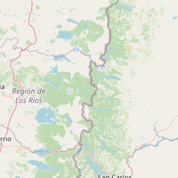
The landscape of Villarrica National Park is defined by its dramatic volcanic terrain, where three major stratovolcanoes create a transverse chain across the Andean range. The centerpiece volcanoes rise dramatically from the surrounding terrain, with snow-capped peaks visible for considerable distances across the Chilean Central Valley. Between and around these major peaks, the park encompasses smaller volcanic features, volcanic plateaus, and the debris-filled valleys that drain the highland catchments. The elevation range from 600 meters to 3,776 meters creates diverse landforms including steep alpine slopes, forested valleys, glacial cirques, and volcanic crater lakes. Several significant lakes dot the park's landscape, including Laguna Quillelhue and smaller bodies such as Laguna Blanca, Laguna Azul, Laguna Verde, Laguna Huinfiuca, Laguna Avutardas, and Laguna Los Patos. The terrain near Cerro Las Peinetas forms part of the border region with Argentina, adding international dimension to the park's geography. The underlying volcanic geology influences both the terrain's visual character and the presence of thermal features that manifest in the park's hot spring systems.
Villarrica National Park ecosystems, habitats, and plant life
Villarrica National Park protects some of the finest examples of Andean temperate rainforest in Chile, representing the southern extension of forest ecosystems that characterize the western slopes of the Andes in this latitude. At lower elevations, the forest is dominated by deciduous southern beeches including roble (Nothofagus obliqua) and raulí (Nothofagus alpina), which create colorful autumn displays as their leaves turn. In the wettest areas, coihue (Nothofagus dombeyi) forms dense canopy cover. As elevation increases, the forest composition shifts to coniferous associations dominated by the iconic araucaria (Araucaria araucana), also known as pehuén, which represents one of the southernmost populations of this ancient conifer species. The park's position within a biosphere reserve recognizes its importance in conserving the biodiversity associated with these forest types. The diverse topography and multiple ecological zones support a range of plant communities from valley-floor rainforest to subalpine vegetation near the volcanic summits.
Villarrica National Park wildlife and species highlights
The forests and alpine habitats of Villarrica National Park support a diverse community of wildlife species, with particular significance attached to several notable mammals and birds. The park provides habitat for pumas (cougars), the largest feline predators in South America, along with smaller canids including chillas (South American gray foxes) and culpeos (Andean foxes). The pudú, one of the smallest deer species in the world, inhabits the forest understory, while coypus (nutrias) are found near water bodies. The unusual monitos del monte (Monito del monte), a small marsupial, represents a particularly significant species as one of the few surviving members of an ancient marsupial lineage. Bird life includes Harris's hawks circling thermals above the volcanic slopes, lesser grisons and Molina's hog-nosed skunks traversing the forest floor, and various waterfowl inhabiting the park's lakes and wetlands.
Villarrica National Park conservation status and protection priorities
Villarrica National Park represents a cornerstone of Chile's protected area network in the southern Andes, preserving critical habitat within the broader Bosques Templados Lluviosos de los Andes Australes Biosphere Reserve. The park's protection encompasses both the volcanic landscape's aesthetic and geological values and the functional ecological role of its forests in watershed protection, carbon storage, and biodiversity conservation. The inclusion of three major volcanic peaks within a single protected area ensures the continuity of alpine ecosystems that might otherwise face fragmentation from development pressure. The park also serves as a wildlife corridor connecting higher-elevation Andean habitats with lower-elevation forest and valley ecosystems. Conservation management focuses on balancing visitor use with resource protection, particularly around the hot springs and ski areas where infrastructure development has occurred.
Villarrica National Park cultural meaning and human context
The territory surrounding Villarrica National Park has been inhabited by Mapuche communities for centuries, and the region's cultural landscape reflects this long history of indigenous presence. The Mapuche people have traditional connections to the volcanic peaks, which hold spiritual significance in their cosmology. The park area lies within territory that was subject to historical tensions between indigenous communities and colonial and later national governments. While the park's establishment formalized state protection over the area, itoverlay land use patterns that predated the protected area designation. Nearby Pucón has developed as a gateway community heavily dependent on tourism generated by the park and the broader adventure tourism potential of the volcanic landscape.
Top sights and standout views in Villarrica National Park
The three volcanic peaks of Villarrica, Quetrupillán, and Lanín form an extraordinary skyline that defines the park's visual identity and draws visitors seeking mountain experiences. The Termas Geométricas hot springs offer a distinctive thermal bathing experience with over 60 pools scattered through a forested ravine, accessible via an extensive network of wooden boardwalks. The araucaria forests at higher elevations represent some of the finest examples of this ancient conifer species, creating photo-worthy landscapes particularly in autumn when the deciduous beeches provide additional color. The ski area on Villarrica volcano provides winter sports opportunities unusual for a national park setting, while the summer months offer hiking, wildlife viewing, and access to crater viewpoints. The lakes scattered throughout the park provide tranquil settings for visitors seeking more contemplative nature experiences away from the volcanic summits.
Best time to visit Villarrica National Park
Villarrica National Park offers distinct seasonal experiences shaped by its mountain environment and volcanic setting. The summer months from December through March bring the warmest conditions and longest days, making this the most popular time for hiking, camping, and general exploration. During this period, the high-elevation trails become fully accessible and the hot springs provide comfortable bathing in the forest setting. Winter from June through September transforms the landscape as snow blankets the volcanic peaks, creating dramatic scenery and enabling ski activities on Villarrica's slopes. The shoulder seasons of spring and autumn offer quieter conditions and different aesthetic qualities, with autumn particularly noteworthy for the golden and red foliage of the deciduous forests in the lower elevations. The park's high-elevation areas may experience closures or restricted access during winter conditions, while the hot springs remain a year-round attraction when weather permits.