

Mori Atlas logo
National parkVolcanoes National Park

Understanding the mapped boundaries and regional geography of this vital national park.

Volcanoes National Park: Protected Landscape Atlas and Geographic Context in Rwanda

Volcanoes National Park in Rwanda represents a significant protected landscape situated within the dramatic geography of the Virunga Mountains. As a designated National Park, it serves as a critical element of Rwanda's conservation efforts, offering a unique glimpse into the region's volcanic terrain and natural heritage. This page provides essential atlas-style context, detailing the park's geographic placement, its mapped boundaries, and its role within the broader East African landscape, aiding in structured discovery of protected areas.

mountain gorillaVirunga Mountainsvolcanic landscaperainforestprimatestransfrontier conservation

Volcanoes National Park

National park

Park overview

Structured park overview, official facts, and landscape profile for Volcanoes National Park

Volcanoes National Park park facts, protected area profile, and essential visitor context

Review the core facts for Volcanoes National Park, including designation, size, terrain, visitor scale, habitats, and operating context in one park-focused overview.

About Volcanoes National Park

Volcanoes National Park represents one of Africa's most significant conservation landscapes, where the dramatic peaks of the Virunga Mountains rise steeply above the surrounding farmland of Rwanda's Musanze District. The park's location at the intersection of the Albertine Rift and the Virunga volcanic chain creates a unique combination of geological drama and ecological diversity. Beyond its global reputation for gorilla conservation, the park contains remarkably diverse vegetation communities that change with elevation, from lower montane forest through bamboo stands to Afro-alpine meadows. The park's boundaries encompass not only the volcanic slopes but also significant cultural heritage sites, including the ancient Buhanga Eco-Park with its traditional Rwandan folklore significance and the Musanze Caves, geological formations approximately 62 million years old. The park's accessibility from Kigali, approximately two hours by road, has made it the centerpiece of Rwanda's nature-based tourism sector, with gorilla tracking permits representing a significant contribution to both conservation funding and local community economies.

Quick facts and research context for Volcanoes National Park

Volcanoes National Park spans 160 square kilometers in northwestern Rwanda, protecting the Rwandan portion of the Virunga Mountains. The park safeguards five volcanic peaks and their surrounding montane forests, ranging from approximately 2,400 to 4,500 meters in elevation. It is globally significant as the primary habitat for the endangered mountain gorilla and serves as the location where pioneering primatologist Dian Fossey established her landmark research center in 1967. The park features distinct ecological zones including bamboo forest, Hagenia-Hypericum woodlands, and Afro-alpine vegetation communities.

Protection and recognition

Tracking terrestrial protection limits and transboundary coordination for shared conservation areas

Documented Protection Status and Transboundary Geography of Volcanoes National Park

Map-based exploration of Volcanoes National Park reveals a dedicated terrestrial protection scope that operates within a vital transboundary framework. Understanding official boundaries and cross-border designations helps researchers compare international conservation structures and analyze regional wilderness security.

Protection details

Protection scope
Terrestrial
Transboundary protection
Yes
Park context

Deeper park guide and search-rich context for Volcanoes National Park

Volcanoes National Park history, landscape, wildlife, and travel context

Explore Volcanoes National Park through its history, landscape character, ecosystems, wildlife, conservation priorities, cultural context, and seasonal travel timing in a structured park guide built for atlas discovery and search intent.

Why Volcanoes National Park stands out

Volcanoes National Park is world-renowned as one of the last strongholds of the mountain gorilla, hosting approximately half of the remaining population of this critically endangered subspecies. The park's volcanic backdrop, rising dramatically above the Albertine Rift, provides a spectacular setting for gorilla tracking and wildlife encounters. It is equally notable for its population of golden monkeys, whose vibrant golden-orange fur contrasts strikingly against the dark forest understory. The park's association with Dian Fossey, who dedicated nearly two decades to gorilla conservation before her murder in 1985, has cemented its place in both conservation history and popular consciousness, particularly through the film adaptation of her autobiography.

Volcanoes National Park history and protected-area timeline

The establishment of Volcanoes National Park in 1925 marked a watershed moment in African conservation history, as it became the first national park on the continent. Initially created as a small protected area encompassing Karisimbi, Bisoke, and Mikeno, the park's original purpose was to shield mountain gorillas from the threat of poaching. In 1929, the Belgian colonial administration expanded the boundaries significantly, incorporating additional Rwandese territory and extending into the Belgian Congo to create Albert National Park, an 8,090 square kilometer transfrontier protected area. Throughout the mid-twentieth century, the park experienced significant human pressures, including the clearance of 700 hectares in 1958 for human settlement and the conversion of 1,050 hectares between 1969 and 1973 for pyrethrum cultivation. The 1970s and 1980s saw the involuntary resettlement of the indigenous Twa people from the park area. The park gained international prominence through the work of American primatologist Dian Fossey, who arrived in 1967 and established the Karisoke Research Centre between Karisimbi and Bisoke, dedicating her career to gorilla research and conservation until her murder in 1985. During the Rwandan Civil War in the early 1990s, the park became a battlefield, leading to the abandonment of the research centre and suspension of tourism until 1999. Recent history has seen the park's expansion, with the Rwandan Government announcing plans in 2022 to increase the protected area from 13,000 to 23,000 hectares.

Volcanoes National Park landscape and geographic character

The landscape of Volcanoes National Park is defined by its dramatic volcanic terrain, where steep-sided volcanic cones rise abruptly from the surrounding East African plateau. The five protected volcanoes each present distinct topographic characters, with Mount Karisimbi standing as the highest peak at 4,507 meters, its summit often capped with frost during the cooler months. The terrain is characterized by rugged lava flows, steep ravines, and dense vegetation covering the volcanic slopes. Between the volcanic peaks, the landscape transitions through distinct altitudinal zones, with the lower slopes supporting agricultural terracing where local communities cultivate the fertile volcanic soils. Within the park boundaries, the topography varies from gentle slopes in the bamboo forest zones to steep, almost vertical terrain on the upper volcanic flanks. The Musanze Caves, located within the park, represent a significant geological feature, formed approximately 62 million years ago following the last major volcanic eruption in the region.

Volcanoes National Park ecosystems, habitats, and plant life

The ecological diversity of Volcanoes National Park reflects its remarkable altitudinal range, supporting multiple distinct vegetation zones within a relatively limited area. The lower montane forest, now largely reduced due to agricultural expansion, once covered the slopes below 2,400 meters. Between 2,400 and 2,500 meters, Neoboutonia forest dominates, transitioning into extensive bamboo forest of Oldeania alpina that covers approximately 30 percent of the park area between 2,500 and 3,200 meters. The Hagenia-Hypericum forest, one of the largest continuous stands of Hagenia abyssinica in Africa, occupies the humid slopes between 2,600 and 3,600 meters, also covering roughly 30 percent of the total area. Above 3,500 meters, the vegetation transitions to Afro-alpine communities characterized by giant lobelia species including Lobelia wollastonii and Lobelia lanurensis, together with Dendrosenecio ericirsenii, covering about 25 percent of the park. The highest elevations support montane grasslands extending from 4,300 to 4,500 meters. Secondary thicket, meadows, marshes, swamps, and small lakes occur in scattered locations throughout the park.

Volcanoes National Park wildlife and species highlights

The wildlife of Volcanoes National Park is headlined by the mountain gorilla, whose population within the park represents one of the most important remnant populations of this critically endangered subspecies. Gorilla families have been habituated for tourist viewing, allowing visitors to observe these gentle primates in their natural forest environment. The park also supports significant populations of golden monkeys, whose striking coloration makes them a memorable sighting for visitors. Other mammalian residents include the black-fronted duiker, African buffalo, spotted hyena, and harnessed bushbuck, with population estimates for bushbuck ranging from approximately 1,760 to 7,040 individuals. African elephants have been reported in the park but now occur only rarely. The avifauna includes 178 recorded bird species, with at least 13 species and 16 subspecies endemic to the Virunga and Rwenzori Mountains, making the park particularly significant for bird conservation in the Albertine Rift region.

Volcanoes National Park conservation status and protection priorities

Volcanoes National Park occupies a critical position in global conservation, serving as a primary stronghold for the mountain gorilla whose total population numbers only approximately 1,000 individuals across its entire range. The park's conservation value extends beyond gorilla protection to encompass the entire Virunga ecosystem, functioning as part of a transfrontier protected area network that allows wildlife movement across international boundaries. The 2022 expansion announcement, which proposes increasing the park from 13,000 to 23,000 hectares, demonstrates Rwanda's commitment to strengthening conservation outcomes while addressing human-wildlife conflict through the creation of buffer zones for agriculture and agroforestry. The expansion is projected to reduce human-wildlife conflicts by 80 percent, illustrating a progressive approach to integrating community needs with conservation objectives. Tourism revenue from gorilla tracking permits has become a crucial funding mechanism for park management and provides direct economic benefits to surrounding communities.

Volcanoes National Park cultural meaning and human context

Volcanoes National Park holds significant cultural importance for Rwanda beyond its ecological value. The park contains Buhanga Eco-Park, an ancient woodland that preserves Rwanda's richest folklore traditions and serves as a living repository of cultural heritage. The indigenous Twa people, who historically inhabited the Virunga region, were forcibly relocated from the park during the 1970s and 1980s, representing a complex historical dimension to the park's conservation narrative. The park is closely associated with the legacy of Dian Fossey, whose pioneering work in gorilla conservation transformed international understanding of these primates and established Rwanda as a global leader in mountain gorilla protection. Fossey is buried within the park near her Karisoke Research Centre, alongside the gorillas that became her life's work. The landscape surrounding the park remains inhabited by Rwandan communities whose agricultural practices and traditional land use shape the interface between human settlement and protected habitat.

Top sights and standout views in Volcanoes National Park

The mountain gorilla remains the definitive highlight of Volcanoes National Park, offering visitors the extraordinary opportunity to observe these endangered primates in their natural habitat. The dramatic volcanic backdrop of the Virunga peaks provides an incomparable setting for trekking through montane forest. The park's population of golden monkeys offers a second primate species of exceptional interest, with their distinctive golden-orange fur creating a vivid contrast against the forest. The historical resonance of Dian Fossey's Karisoke Research Centre, where her grave still stands among the gorillas, provides a profound connection to the history of primate conservation. The Musanze Caves offer a geological complement to the park's above-ground attractions, while Buhanga Eco-Park provides cultural enrichment through its association with Rwandan traditions.

Best time to visit Volcanoes National Park

The dry seasons from June to September and December to February generally offer the most favorable conditions for visiting Volcanoes National Park, with reduced rainfall making forest trails more manageable and wildlife viewing more accessible. However, the park remains accessible throughout the year, and each season offers distinct advantages. The wet seasons bring lush green vegetation and potentially lower tourist numbers, though trails can become muddy and more physically demanding. Gorilla tracking is possible year-round, and the experience remains remarkable regardless of season. The park's high altitude location means temperatures are cool to cold, particularly at higher elevations, and visitors should prepare for conditions that can change rapidly regardless of season.
Monthly climate preview

Track the stable temperature ranges and seasonal precipitation cycles of the Rwandan highlands.

Monthly Average Temperatures and Precipitation for Volcanoes National Park

Long term measurements at the representative highland coordinate show mild temperatures with mean monthly averages consistently hovering between sixteen and nineteen degrees Celsius. Exploring the full twelve month breakdown reveals seasonal precipitation fluctuations alongside detailed minimum and maximum temperature variations.
Annual mean17 °C
17 °C18 °C
Jan17°
Feb18°
Mar18°
Apr18°
May17°
Jun17°
Jul17°
Aug18°
Sep18°
Oct18°
Nov17°
Dec17°
Warmest month
March

18.2 °C

Coolest month
June

16.8 °C

Wettest month
November

6.7 mm/day

Driest month
July

1.2 mm/day

Park location guide

Geography guide, regional context, and park location map for Volcanoes National Park

Volcanoes National Park park geography, regions, and map view in Rwanda

Understand where Volcanoes National Park sits in Rwanda through a broader geographic reading of the surrounding landscape, nearby location context, and its mapped position within the national park landscape.

How Volcanoes National Park fits into Rwanda

Rwanda is a landlocked East African nation bordered by Uganda, Tanzania, Burundi, and the Democratic Republic of the Congo. The country features mountains in the west, savanna in the southeast, and several volcanoes in the northwest forming part of the Virunga chain. It has a tropical highland climate with two rainy and two dry seasons annually.

Wider geography shaping Volcanoes National Park in Rwanda

Rwanda lies in the Great Rift Valley of East Africa, bordered by Uganda to the north, Tanzania to the east, Burundi to the south, and the Democratic Republic of the Congo to the west. The western region features mountains and lakes, while the southeast consists of savanna. Several volcanoes forming part of the Virunga Mountains are located in the northwest.

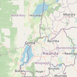
Map view of Volcanoes National Park

Use this park location map to pinpoint Volcanoes National Park in Rwanda, understand its exact geographic position, and read its mapped placement within the surrounding landscape more clearly.

Pigeon | © OpenStreetMap contributors
Park atlas

Trace the broader network of protected areas and volcanic terrain adjacent to Rwanda's iconic park.

Discover Nearby National Parks and Protected Areas Beyond Volcanoes National Park

After exploring Volcanoes National Park, trace other prominent national parks and protected landscapes across the Virunga Mountains and neighboring East African countries. Comparing these areas reveals the continuous transfrontier conservation efforts and diverse volcanic terrain extending across international boundaries, enriching your atlas-style discovery.
Watercolor painting showing green and pink trees, hills in background, and grass in foreground
National parkRwanda
Mapped park locations coincide#1 closest

Volcans National Park: Explore its Protected Landscape and Geographic Identity

Mapped boundaries and regional natural terrain.

Volcans National Park represents a vital national park entity, offering a distinct protected landscape for geographic study. Its mapped boundaries and natural terrain provide crucial context for understanding regional geography and the broader atlas of protected areas. This page serves as a dedicated point for exploring the park's specific contribution to natural landscape discovery, focusing on its geographic character and protected status.

Area
160 km²
Established
1925
Relief
Mountain
Climate
Temperate
Watercolor illustration of rolling hills, mountains, and a river or lake
National parkDemocratic Republic of the Congo
About 1.3 km away#2 closest

Northwest

Virunga National Park: Democratic Republic of the Congo's Premier Protected Landscape

Mapped boundaries and diverse Albertine Rift endemic geography.

Virunga National Park represents a pivotal protected area within the Democratic Republic of the Congo, characterized by an exceptional range of geographic features and vital ecosystems. Its protected landscape includes active volcanoes like Nyiragongo with its lava lake, the towering Rwenzori Mountains, and diverse lowland savannas. This atlas-focused entry highlights the park's unique position in the Albertine Rift, crucial for numerous endemic species and offering significant insight into regional geography and protected land context.

Area
7,800 km²
Established
1925
IUCN
II
Relief
Mountain
National parkKisoro District
About 20 km away#3 closest

Northeast

Mgahinga Gorilla National Park: A Geographic Study of Virunga Mountain Landscapes

Exploring protected boundaries and volcanic terrain in Kisoro District.

Mgahinga Gorilla National Park covers an essential range of montane forest and alpine zones across three dormant volcanoes in the Kisoro District of Uganda. This protected area functions as a key element of the broader Virunga mountain ecosystem, providing specialized habitats for endangered primate populations and endemic bird species. The dramatic vertical relief from bamboo forests to summit peaks defines this critical segment of the Albertine Rift conservation network.

Area
33.9 km²
Established
1991
IUCN
II
Relief
Mountain
National parkUganda
About 28 km away#4 closest

Northeast

Mgahinga Gorilla National Park: Atlas of Protected Volcanic Landscapes in Uganda

Mapping the Virunga Mountains and high altitude conservation terrain.

Located in southwestern Uganda, Mgahinga Gorilla National Park protects a significant portion of the transboundary Virunga ecosystem. The park encompasses the peaks of Mount Muhabura, Mount Gahinga, and Mount Sabyinyo, providing a unique look at the vertical transition of habitats from bamboo forests to alpine zones. Access detailed geographic data and spatial context for one of the most ecologically important protected areas in the Albertine Rift.

Area
33.9 km²
Established
1991
IUCN
II
Relief
Mountain
National parkWestern Province
About 32 km away#5 closest

South

Gishwati Forest National Park: Discover Rwanda's Protected Landscape Geography

Mapped protected area boundaries and regional natural landscape.

Gishwati Forest National Park offers a focused exploration of a significant protected natural landscape in Rwanda's Western Province. This resource provides detailed geographic context, highlighting the park's mapped boundaries and its role within the country's conservation areas. Understand its terrain and regional landscape importance through an atlas-centric view.

Area
32.02 km²
Established
2015
IUCN
IV
Relief
Mountain
National parkRwanda
About 32 km away#6 closest

South

Gishwati-Mukura National Park: Rwanda's Protected Montane Forest Landscape in the Albertine Rift

Explore its mapped boundaries and regional geography.

Gishwati-Mukura National Park, located in western Rwanda, is a vital protected area renowned for its montane forest ecosystems. This national park occupies mountainous terrain characteristic of the Albertine Rift, contributing significantly to watershed protection and regional biodiversity. Users can explore its specific geographic context, mapped landscape features, and its role within Rwanda's broader conservation atlas.

Area
32.02 km²
Established
2015
IUCN
II
Relief
Highland
National parkKanungu District
About 44 km away#7 closest

North

Bwindi Impenetrable National Park: Uganda's National Park Geography and Mapped Terrain

Explore its protected landscape and regional context.

Delve into the protected landscape of Bwindi Impenetrable National Park, a protected area situated within Kanungu District, Uganda. This detail page offers a deep dive into its geographic setting, presenting mapped park boundaries and natural terrain features essential for understanding its role within the regional atlas. Discover the specific environmental context of this national park for robust map-based exploration.

Area
331 km²
Established
1991
IUCN
II
Relief
Mountain
National parkSouth Kivu Province
About 105 km away#8 closest

Southwest

Kahuzi-Biéga National Park: Protected Mountain and Rainforest Geography in South Kivu

Mapped terrain from volcanic summits to equatorial forest basins.

Kahuzi-Biéga National Park represents a significant protected area within the South Kivu Province. The geography features two distinct sectors connected by a narrow ecological corridor, encompassing everything from high-altitude subalpine heather zones to dense tropical lowland environments. This dataset provides a detailed look at the park boundaries, volcanic topography, and the regional landscape context that defines this essential habitat.

Area
6,000 km²
Established
1970
IUCN
II
Relief
Mixed relief

Common questions about visiting, size, designation, and location context for Volcanoes National Park

Volcanoes National Park FAQs for park facts, access, geography, and protected area context

Find quick answers about Volcanoes National Park, including protected-area facts, park geography, trail and visitor context, and how the park fits into its surrounding country and regional landscape.
MoriAtlas Explorer

Continue Your Protected Areas Search Across the Global Atlas

Deepen your exploration by continuing the structured search for national parks and protected areas worldwide. Utilize the comprehensive filtering capabilities to compare different conservation landscapes and refine your understanding of global park geography. Discover more about the distribution and characteristics of protected natural areas.

Global natural geography


