

Mori Atlas logo
National parkYala National Park

Discover the mapped boundaries and regional context of Yala National Park in Southern Province.

Yala National Park National Park: Geographic Identity and Protected Landscape Exploration

Yala National Park stands as a key national park within Sri Lanka's Southern Province, offering a unique perspective on protected lands. This page provides detailed geographic insights, focusing on the park's mapped boundaries and its place within the regional landscape. Explore Yala National Park's identity as a distinct protected area and understand its cartographic representation for comprehensive geographic discovery.

National ParkWildlife SafariLeopard ConservationElephant HabitatBirdwatchingCoastal Wetlands

Yala National Park

National park

Park overview

Structured park overview, official facts, and landscape profile for Yala National Park

Yala National Park park facts, protected area profile, and essential visitor context
Review the core facts for Yala National Park, including designation, size, terrain, visitor scale, habitats, and operating context in one park-focused overview.

About Yala National Park

Yala National Park stands as Sri Lanka's flagship protected area and one of South Asia's most significant wildlife conservation landscapes. Located in the southeastern region of the island, the park straddles the Southern and Uva Provinces, extending from the interior plains to the Indian Ocean coastline. The park's vast expanse of nearly 1,000 square kilometers encompasses a remarkable mosaic of ecological zones that support extraordinary biodiversity within a relatively accessible framework for visitors. The landscape transitions from forested areas concentrated around the Menik River in the west to extensive open grasslands known as pelessa that extend toward the coastal zone. This habitat diversity creates optimal conditions for the park's remarkable mammal populations, which include not only the famous leopards and elephants but also threatened species such as the Sri Lankan sloth bear and wild water buffalo. The park's significance extends beyond its ecological value to encompass deep historical and cultural dimensions, with ancient Buddhist archaeological sites scattered throughout the reserve.

Quick facts and research context for Yala National Park

Yala National Park occupies a coastal lowland position in Sri Lanka's dry semi-arid climatic region, with elevations ranging from near sea level to approximately 125 meters. The area experiences a mean annual rainfall between 500 to 775 millimeters, primarily during the northeast monsoon season. The park is divided into five administrative blocks that were incorporated at different times between 1938 and 1973, with Block I being the original core area. Surface water resources include numerous tanks, waterholes, rock pools, streams, and coastal lagoons that become critical wildlife refuges during the dry season. The park hosts 44 mammal species, 215 bird species including six endemic to Sri Lanka, and 47 reptile species. Key rivers including the Menik River and Kumbukkan Oya flow through the park, providing essential water sources for wildlife.

Park context

Deeper park guide and search-rich context for Yala National Park

Yala National Park history, landscape, wildlife, and travel context
Explore Yala National Park through its history, landscape character, ecosystems, wildlife, conservation priorities, cultural context, and seasonal travel timing in a structured park guide built for atlas discovery and search intent.

Why Yala National Park stands out

Yala National Park is world-famous for its exceptional leopard population, which represents the highest density of these elusive big cats found anywhere on the planet. The park serves as a critical stronghold for the endangered Sri Lankan leopard, with Block I alone supporting an estimated 25 individuals. Beyond leopards, the park is celebrated for its substantial Sri Lankan elephant herds that congregate around permanent water sources during dry seasons. The park's ecological significance is further underscored by its designation as one of Sri Lanka's 70 Important Bird Areas, supporting over 215 avian species including both resident populations and migratory waterfowl that arrive in vast numbers during the northeast monsoon. The combination of diverse habitats supporting mega-fauna, the big cat spectacle, and accessible wildlife viewing makes Yala Sri Lanka's premier safari destination.

Yala National Park history and protected-area timeline

The area now protected as Yala National Park has a documented history stretching back centuries, with early cartographic references noting the region as early as 1560 when Spanish cartographer Cipriano Sánchez recorded Yala on maps, describing it as abandoned for 300 years due to insalubrious conditions. The modern protection trajectory began in 1900 when the government proclaimed Yala and Wilpattu reserves under the Forest Ordinance, initially encompassing 389 square kilometers between the Menik and Kumbukkan Rivers. The Game Protection Society, now the Wildlife and Nature Protection Society, played a instrumental role in establishing the reserve. On March 1, 1938, Yala achieved national park status when the Flora and Fauna Protection Ordinance was passed into law by D.S. Senanayake, the minister of agriculture. The original park consisted of five blocks, with subsequent expansion incorporating four additional blocks between 1954 and 1973. A notable milestone in the park's conservation history occurred in 1958 when Game Ranger Liyanage John Stanley Fernando was photographed with a rescued leopard cub, representing one of the earliest documented examples of human-wildlife coexistence in Sri Lanka's protected area management.

Yala National Park landscape and geographic character

The physical landscape of Yala National Park is characterized by its position in the lowest peneplain of Sri Lanka, a flat to mildly undulating plain that extends from Trincomalee to Hambantota along the island's southeastern coast. The underlying geology consists predominantly of metamorphic rocks from the Precambrian era, classified into the Vijayan and Highland series. Topographically, elevations range from approximately 30 meters near the coast to 100 to 125 meters in the interior regions. The park's terrain encompasses several distinct landscape elements: the forest areas along the Menik River, the open pelessa grasslands extending toward the sea, coastal dune systems, and a network of freshwater and brackish water bodies including tanks, waterholes, rock pools, and lagoons. Reddish brown soils and low humic grey soils represent the primary soil types across six distinct categories found within the park. The coastal fringe features several lagoons and beaches, with Patanangala being a notable rock outcrop along the shoreline.

Yala National Park ecosystems, habitats, and plant life

Yala National Park protects an exceptional range of ecosystems that reflect Sri Lanka's ecological diversity within a semi-arid context. The park contains moist monsoon forests, dry monsoon forests, semi-deciduous forests, thorn forests, grasslands, marshes, marine wetlands, and sandy beach environments. The forest cover is primarily concentrated in Block I and along the Menik River corridor, while open rangelands and grasslands dominate the areas extending toward the coastline. The mangrove systems in coastal lagoons, particularly in the Buthuwa and Block II estuary areas, support specialized brackish water vegetation including Rhizophora mucronata, Sonneratia caseolaris, and Avicennia species. The Blocks III, IV, and V feature more extensive forest cover with canopy species including Drypetes sepiaria and Manilkara hexandra. The pitiya grasslands provide crucial grazing habitat for herbivores, while the network of tanks, waterholes, and seasonal water bodies supports aquatic and semi-aquatic species throughout the year.

Yala National Park wildlife and species highlights

The wildlife communities within Yala National Park represent one of the richest assemblages in South Asia, anchored by the park's remarkable leopard population, which achieves the highest density recorded anywhere in the world. Block I alone supports an estimated 25 individual Sri Lankan leopards, making Yala the premier location for observing these elusive predators in the wild. The Sri Lankan elephant population migrates seasonally through the park, congregating around the network of waterholes and rock pools that retain water year-round. Beyond the flagship species, Yala supports 44 mammal species including the threatened Sri Lankan sloth bear, wild water buffalo, toque macaque, golden palm civet, red slender loris, and fishing cat. The avifauna is equally impressive, with 215 bird species recorded, including seven endemic to Sri Lanka such as the Sri Lanka grey hornbill, Sri Lanka junglefowl, and Sri Lanka wood pigeon. The wetlands attract 90 waterbird species, half of which are migratory visitors arriving during the northeast monsoon. Reptile diversity includes 47 species with both mugger and saltwater crocodiles present, alongside five globally endangered sea turtle species that nest along the coastal beaches.

Yala National Park conservation status and protection priorities

Yala National Park faces multiple conservation challenges despite its protected status. The primary threats include poaching, gem mining along the Menik River, illegal logging, agricultural encroachment, and competition from free-roaming domestic livestock. The park has experienced ranger casualties in confrontations with poachers, highlighting the dangerous nature of anti-poaching efforts. Gem mining activities have created extensive holes extending up to 30 meters deep along riverbanks. In the more remote Blocks III and IV, shifting cultivation and slash-and-burn practices encroach on park boundaries. Environmental concerns include forest dieback in Sonneratia caseolaris groves at the Menik River estuary, invasive species such as Lantana camara, Opuntia dillenii, and Chromolaena odorata that threaten native vegetation, and pollution from tobacco cultivation and tourism activities. The Department of Wildlife Conservation has implemented management measures including grazing land management, small water pond conservation, invasive species eradication, and a 40-kilometer electric fence to prevent human-elephant conflict.

Yala National Park cultural meaning and human context

Yala National Park contains significant cultural and archaeological heritage reflecting millennia of human presence in the region. The area was a center of ancient civilizations, with evidence of sophisticated hydraulic agricultural systems dating back to the 5th century BC visible in the numerous ancient tanks scattered throughout the park. According to local tradition, King Ravana of Hindu mythology established his kingdom in this area, with Ravana Kotte serving as its boundary marker. Sithulpahuwa, located within the park, was historically home to 12,000 arahants (enlightened Buddhist monks), while Magul Vihara, constructed in 87 BC, and Akasa Chaitiya, dating to the 2nd century BC, represent significant ancient Buddhist sites. The region was part of the Kingdom of Ruhuna, where agricultural prosperity flourished until the decline began in the 13th century according to the Mahavamsa chronicle. During the colonial period, Yala became a popular hunting ground. The park remains a pilgrimage destination, with approximately 400,000 pilgrims visiting annually, particularly to Sithulpahuwa.

Top sights and standout views in Yala National Park

Yala National Park offers the unparalleled opportunity to observe Sri Lankan leopards in the wild at densities found nowhere else on Earth, making it a premier destination for wildlife photography and big cat enthusiasts. The park's elephant herds provide spectacular viewing opportunities, especially during the dry season when animals congregate around permanent water sources. The diversity of ecosystems from forest to coastline supports extraordinary birdlife, with migratory waterfowl creating spectacular congregations in the coastal lagoons during the northeast monsoon. Ancient Buddhist archaeological sites including Sithulpahuwa and Magul Vihara add cultural depth to the safari experience. The combination of accessible wildlife viewing, scenic coastal landscapes featuring rock outcrops like Patanangala, and the chance to encounter multiple threatened species including elephants, leopards, sloth bears, and crocodiles within a single visit makes Yala Sri Lanka's most comprehensive wildlife destination.

Best time to visit Yala National Park

The optimal time to visit Yala National Park is during the dry season from February to June, when reduced water availability concentrates wildlife around the remaining waterholes and rivers, making animal sightings more predictable. The northeast monsoon brings rainfall from December to March, transforming the landscape with lush vegetation but potentially making wildlife more dispersed and harder to locate. The period from May to September typically offers the best leopard sighting opportunities as vegetation thins and animals seek water. However, the park remains open year-round, with each season offering distinct advantages: the green season from October to November showcases the park's full vegetation vigor while the monsoon period supports exceptional bird migrations. Visitor numbers peak during Sri Lankan holidays, particularly the pilgrimage season to Sithulpahuwa, so planning outside these periods can provide a more tranquil wildlife experience.
Park location guide

Geography guide, regional context, and park location map for Yala National Park

Yala National Park park geography, regions, and map view in Sri Lanka
Understand where Yala National Park sits in Sri Lanka through a broader geographic reading of the surrounding landscape, nearby location context, and its mapped position within the national park landscape.

How Yala National Park fits into Sri Lanka

Sri Lanka is a tropical island nation in South Asia with a recorded history spanning over 3,000 years. Formerly known as Ceylon, it became independent in 1948 and adopted its current constitutional name in 1972. The country features diverse geography ranging from coastal plains to mountainous highlands and maintains a population exceeding 22 million.

Wider geography shaping Yala National Park in Sri Lanka

Sri Lanka is an island nation in the Indian Ocean, positioned southwest of the Bay of Bengal. It is separated from India by the Gulf of Mannar and Palk Strait to the northwest. The island has a pear-like shape with diverse terrain including coastal plains, central highlands, and river valleys.

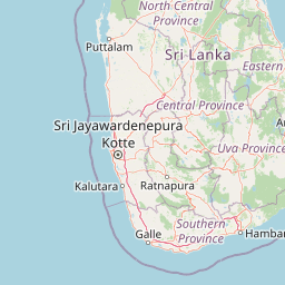
Map view of Yala National Park

Use this park location map to pinpoint Yala National Park in Sri Lanka, understand its exact geographic position, and read its mapped placement within the surrounding landscape more clearly.

Pigeon | © OpenStreetMap contributors

Location context for Yala National Park

Southern ProvinceUva Province
Park atlas

Trace the geographic spread of wildlife sanctuaries and diverse protected landscapes connected to Yala National Park's coastal region.

Discover Nearby National Parks and Protected Areas Beyond Yala National Park, Tracing Sri Lanka's Southeastern Coastal Landscapes
Explore other national parks and protected areas situated in the broader region surrounding Yala National Park, featuring diverse coastal wetlands, dry zone forests, and crucial wildlife habitats across southeastern Sri Lanka. Compare these unique conservation landscapes to understand their regional context and continue your atlas-style park discovery journey through mapped geography and structured park facts.
National parkEastern Province

Kumana National Park: Detailed Geographic and Protected Landscape Exploration

Mapped boundaries and regional context for this national park.

Delve into the protected landscape of Kumana National Park, a designated national park situated in Sri Lanka's Eastern Province. This dedicated exploration surface provides detailed geographic information, helping you understand the park's mapped boundaries, surrounding terrain, and its significance within the regional context. It is designed for users seeking a structured understanding of protected areas and their place in the broader atlas.

Area
356.64 km²
Established
1970
IUCN
II
Relief
Lowland
National parkSri Lanka

Lunugamvehera National Park: Sri Lanka's Protected Area Mapping and Geographic Identity

Mapped terrain and national park boundaries in Sri Lanka.

Lunugamvehera National Park is a dedicated national park situated in Sri Lanka. This entry facilitates a focused exploration of its protected landscape, offering insight into its mapped geography and position within the country's conservation network. Understand the park's role and its physical characteristics through detailed geographic and atlas-oriented information.

Area
234.988 km²
Established
1995
IUCN
II
Relief
Lowland
National parkEastern Province

Lahugala Kitulana National Park: Eastern Province National Park Protected Landscape Discovery

Explore mapped boundaries and regional geography.

Lahugala Kitulana National Park is a key protected area, designated as a national park within Sri Lanka's Eastern Province. This content focuses on its geographic identity, including mapped park boundaries and its regional landscape context. Gain a structured understanding of this protected natural land for atlas-based exploration, highlighting its geographical significance and protected status.

Area
15.54 km²
Established
1980
IUCN
II
Relief
Lowland
Watercolor illustration of a landscape with green hills, grassy foreground, and pink sky
National parkSri Lanka

Ussangoda National Park: Sri Lanka's National Park and Protected Landscape Atlas Entry

Mapped protected boundaries and regional geographic context.

Ussangoda National Park represents a vital component of Sri Lanka's protected natural areas, offering unique insights into its landscape and geography. This atlas entry focuses on the park's identity as a national park, providing a detailed view of its mapped boundaries and its specific location within the island's diverse geography. Understand the protected land context and the unique characteristics that define Ussangoda National Park for focused geographic discovery.

Area
3.49 km²
Established
2010
IUCN
II
Relief
Upland
National parkSri Lanka

Udawalawe National Park: National Park Protected Landscape and Geographic Atlas

Explore Sri Lanka's mapped natural terrain and park boundaries.

Gain a comprehensive atlas-level understanding of Udawalawe National Park, a key protected landscape in Sri Lanka. This entry focuses on the park's distinct geographic identity, its mapped boundaries, and its significance as a protected area within the island's diverse natural terrain. Explore how this national park contributes to the regional geography and provides structured insights for landscape discovery.

Area
308.21 km²
Established
1972
IUCN
II
Visitors
188.4K annual
National parkCentral Province

Horton Plains National Park: A Protected Landscape within Sri Lanka's Central Province

Explore its mapped geographic boundaries and park identity.

Delve into the geographic specifics of Horton Plains National Park, a designated national park located in the Central Province of Sri Lanka. This entry provides detailed insights into its protected area status, mapped landscape features, and regional geographic context. Understand how this park contributes to the atlas of protected lands and offers a distinct point for landscape exploration.

Area
31.6 km²
Established
1988
IUCN
II
Relief
Mountain
National parkUva Province

Gal Oya National Park: Protected Landscape and Reservoir Geography in Uva Province

Explore savannah grasslands, elephant populations, and mapped terrain.

Gal Oya National Park presents a unique protected landscape within Uva Province, Sri Lanka. This national park is defined by its broad savannah grasslands, known as thalawa, interspersed with forested hills and the vast Senanayake Samudraya reservoir. Its varied topography, from lowlands to mountain peaks, offers a rich canvas for geographic exploration and understanding protected-area dynamics. The park's consistent visibility of elephant populations across these diverse terrains makes it a key site for wildlife observation within Sri Lanka's atlas of natural heritage.

Area
259 km²
Established
1954
IUCN
II
Relief
Mountain
National parkCentral Province

Galways Land National Park: A Protected Landscape within Central Province, Sri Lanka

Explore the mapped geography and protected area context of this national park.

Galways Land National Park is a designated national park within the Central Province of Sri Lanka, offering a distinct focus for geographic exploration. This entry provides specific details on its protected landscape characteristics and its place within the regional atlas. Users can examine the mapped boundaries and understand the natural terrain that defines this conservation area. Discover the unique geographic identity of Galways Land National Park and its contribution to the protected areas network.

Area
0.27 km²
Established
2006
IUCN
II
Relief
Mountain

Common questions about visiting, size, designation, and location context for Yala National Park

Yala National Park FAQs for park facts, access, geography, and protected area context
Find quick answers about Yala National Park, including protected-area facts, park geography, trail and visitor context, and how the park fits into its surrounding country and regional landscape.
MoriAtlas Explorer

Continue Your Protected Areas Search Across the Global Atlas

Deepen your exploration by continuing the structured search for national parks and protected areas worldwide. Utilize the comprehensive filtering capabilities to compare different conservation landscapes and refine your understanding of global park geography. Discover more about the distribution and characteristics of protected natural areas.

Global natural geography