

Mori Atlas logo
National parkYalgorup National Park

Discover the mapped boundaries and regional natural landscape of this significant national park.

Yalgorup National Park: Protected Landscape and Geographic Context in Western Australia

Yalgorup National Park stands as a protected natural landscape within Western Australia, offering a distinct geographic identity and valuable context for atlas exploration. This entry focuses on its role as a national park, detailing its mapped boundaries and its contribution to the regional geography of this expansive Australian state. Understand Yalgorup National Park not just as a protected area, but as a key element within the broader mapped terrain and natural landscapes of Western Australia, providing a foundation for structured geographic discovery.

Coastal WetlandsRamsar SiteWestern AustraliaStromatolitesImportant Bird AreaTuart Woodlands

Yalgorup National Park

National park

Park overview

Structured park overview, official facts, and landscape profile for Yalgorup National Park

Yalgorup National Park park facts, protected area profile, and essential visitor context
Review the core facts for Yalgorup National Park, including designation, size, terrain, visitor scale, habitats, and operating context in one park-focused overview.

About Yalgorup National Park

Yalgorup National Park occupies a distinctive position in Western Australia's conservation estate as a protected area that bridges geological, ecological, and cultural significance. The park sits on the Swan Coastal Plain, a region of low-lying terrain between the Indian Ocean and the Darling Range, where a chain of lakes creating the Yalgorup system has formed over geological time through coastal processes and sea level changes. These wetlands, collectively forming part of the larger Peel-Yalgorup Wetland system, represent one of the most important coastal wetland complexes in southwestern Australia, supporting ecological communities that have evolved in response to the region's Mediterranean climate and seasonal water fluctuations. The park's establishment in 1966 reflected growing recognition of the need to protect these wetland ecosystems from development pressures along Western Australia's populated southwest coast. Beyond its ecological importance, the park provides habitat for species assemblages that combine elements of southwestern Australia's unique fauna, from large mammals like western grey kangaroos to smaller marsupials and the diverse bird communities that utilize the lake environments throughout the year.

Quick facts and research context for Yalgorup National Park

Yalgorup National Park spans 131.41 square kilometers along the Swan Coastal Plain in Western Australia, about 105 kilometers south of Perth near Mandurah. The park protects a system of approximately ten lakes forming part of the internationally significant Peel-Yalgorup Wetland system, designated as a Ramsar Wetland Site since 1990. The park contains remarkable living stromatolite colonies, among the youngest such formations on Earth, growing in the shallow waters of its lakes. The wetlands support exceptional bird diversity, recognized as a BirdLife International Important Bird Area, with species including black swans, kingfishers, grebes, waterfowl, and various parrots and dotterels.

Park context

Deeper park guide and search-rich context for Yalgorup National Park

Yalgorup National Park history, landscape, wildlife, and travel context
Explore Yalgorup National Park through its history, landscape character, ecosystems, wildlife, conservation priorities, cultural context, and seasonal travel timing in a structured park guide built for atlas discovery and search intent.

Why Yalgorup National Park stands out

Yalgorup National Park is renowned for two extraordinary natural features that set it apart within Australia's protected area network. The park contains living stromatolite colonies growing in Lake Yalgorup, representing some of the youngest and most accessible stromatolite formations on the planet, offering a window into early life on Earth. Equally significant is the park's role as a critical habitat for waterbirds within the Peel-Yalgorup Wetland system, recognized internationally as a Ramsar site and identified by BirdLife International as an Important Bird Area. The combination of ancient microbial life, diverse wetland ecosystems, and tuart woodland forests creates a remarkable ecological mosaic within this relatively compact coastal plain reserve.

Yalgorup National Park history and protected-area timeline

Yalgorup National Park was established in 1966, emerging during a period when Western Australia began systematically expanding its national park network to protect representative ecosystems across the state. The park's creation reflected increasing scientific understanding of the ecological importance of the Swan Coastal Plain wetlands, which had been subjected to various developmental pressures throughout the twentieth century as the Perth metropolitan region expanded and agricultural activities intensified in the surrounding region. The Peel-Yalgorup Wetland system gained international recognition when it was added to the Ramsar List of Wetlands of International Importance in 1990, acknowledging its significance as a coastal wetland ecosystem of global importance. This designation brought additional management attention and reinforced conservation priorities for the area. The Department of Environment and Conservation, now the Department of Biodiversity, Conservation and Attractions, has administered the park, implementing management strategies that balance public access with the need to protect sensitive wetland habitats and the remarkable stromatolite formations found within the park's lake systems.

Yalgorup National Park landscape and geographic character

The landscape of Yalgorup National Park is defined by its position on the Swan Coastal Plain, a flat to gently undulating region of sands, clays, and coastal sediments that parallels Western Australia's southwestern coastline. The park encompasses a chain of approximately ten lakes, including Boundary Lake, Swan Pond, Lake Pollard, Lake Yalgorup, and Newnham Lake, which occupy linear depressions formed by ancient coastal processes. These shallow, often seasonal lakes create a distinctive wetland landscape that changes dramatically with rainfall patterns and groundwater levels. The park's western boundary approaches the modern coastline, while the eastern portions transition into landscapes influenced by the underlying geology of the coastal plain. Woodland and forest vegetation, particularly the distinctive tuart trees for which the region is famous, occurs on the better-drained soils surrounding the lakes, creating a landscape mosaic of open water, reed beds, and woodlands that characterizes much of the park's visual character.

Yalgorup National Park ecosystems, habitats, and plant life

The ecological character of Yalgorup National Park reflects its position within the Peel-Yalgorup Wetland system, one of southwestern Australia's most significant coastal wetland complexes. The wetlands support a diversity of habitats ranging from open water through emergent vegetation zones to surrounding woodlands, creating ecological gradients that support varied plant and animal communities. The park's lakes provide critical habitat for waterbirds, with the wetland system's seasonal patterns offering feeding and breeding resources for species that migrate through or reside in the region. The surrounding tuart woodlands and forests represent remnants of vegetation communities that once covered much of the Swan Coastal Plain but have been extensively cleared for agriculture and urban development. These woodlands provide important habitat for forest-dwelling species, connecting the aquatic and terrestrial ecological systems within the park. The living stromatolites in Lake Yalgorup represent an extraordinary biological phenomenon, with cyanobacteria communities actively building layered structures that are analogues to some of Earth's earliest life forms.

Yalgorup National Park wildlife and species highlights

Yalgorup National Park supports remarkable wildlife diversity, particularly within its wetland habitats where birdlife reaches exceptional concentrations. The lakes within and adjacent to the park provide crucial habitat for waterbirds, with species including black swans, various kingfisher species, grebes, coots, waterfowl, parrots, and dotterels recorded within the area. The park has been identified by BirdLife International as the Yalgorup Important Bird Area specifically because of its significance for waterbird populations, supporting both resident species and those that move through the region seasonally. Lake Clifton and Lake Preston, both situated within the park boundaries, represent particularly important bird habitats within the broader wetland system. Beyond birds, the park's woodland environments support mammals including western grey kangaroos, emus, brush wallabies, brush-tailed possums, echidnas, and bandicoots. The park's fauna includes species that have survived in remnants of what was once a more continuous woodland landscape across the coastal plain, though populations of some species, notably the quokka, have been eliminated from the area due to predation by introduced foxes.

Yalgorup National Park conservation status and protection priorities

Yalgorup National Park occupies a central position in the conservation of southwestern Australia's coastal wetland ecosystems, with the broader Peel-Yalgorup Wetland system recognized internationally under the Ramsar Convention since 1990. This designation acknowledges wetlands of international importance, particularly for waterbird habitat, and brings responsibilities for management that balances ecological protection with sustainable use. The park's stromatolite colonies represent a unique conservation priority, with these living microbial formations requiring protection from disturbance to maintain their continued growth and scientific value. The park also functions as a refuge for wildlife within a landscape increasingly modified by human activities, preserving ecological communities that have been lost from much of the surrounding Swan Coastal Plain. Management focuses on maintaining water quality, controlling invasive species, and preserving the ecological processes that sustain the wetland system's biodiversity.

Yalgorup National Park cultural meaning and human context

The name Yalgorup originates from the Noongar Aboriginal language, one of the indigenous languages of the southwestern Australian region. The combination of 'Yalgor' meaning lake and '-up' meaning place of creates a name that directly describes the fundamental landscape characteristic of the area as a place of lakes. The Noongar people have traditional connections to the lands and waters of the Swan Coastal Plain region, with the wetland systems providing resources and cultural significance. The broader Peel-Yalgorup region has been inhabited by Aboriginal peoples for thousands of years, with the coastal plain and its wetlands forming part of cultural landscapes that sustained traditional lifestyles. While the park's primary designation focuses on natural values, this cultural dimension adds depth to understanding the landscape's significance beyond its ecological features.

Top sights and standout views in Yalgorup National Park

The living stromatolites of Lake Yalgorup stand as the park's most extraordinary scientific feature, offering a rare opportunity to observe living examples of structures that dominated early life on Earth. The wetland system provides exceptional birdwatching opportunities, with the Yalgorup Important Bird Area supporting diverse waterbird communities in a landscape where such habitats have become increasingly scarce across the broader region. The tuart woodlands surrounding the lakes represent some of the best remaining examples of this distinctive southwestern Australian tree formation. The park's accessibility from Perth and Mandurah makes it a valuable nature-based destination for visitors seeking to experience coastal wetland environments that are otherwise heavily modified across the Swan Coastal Plain.

Best time to visit Yalgorup National Park

The optimal time to experience Yalgorup National Park aligns with Western Australia's Mediterranean climate patterns, with autumn and spring offering mild temperatures and conditions favorable for wildlife observation. The winter months, from June to August, typically bring increased rainfall that fills the lakes and enhances wetland bird activity, though some tracks may be affected by wet conditions. Summer months can see lake levels decline significantly, concentrating wildlife around remaining water sources but potentially reducing the overall wetland character. BirdLife International's recognition of the area highlights waterbird populations, which are most observable during the cooler months when migratory species are present alongside resident populations. The park can be visited year-round, though visitors interested in witnessing the wetland system at its most vibrant should consider the cooler, wetter season when water levels are higher and bird activity is most pronounced.
Park location guide

Geography guide, regional context, and park location map for Yalgorup National Park

Yalgorup National Park park geography, regions, and map view in Australia
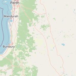
Understand where Yalgorup National Park sits in Australia through a broader geographic reading of the surrounding landscape, nearby location context, and its mapped position within the national park landscape.

How Yalgorup National Park fits into Australia

Australia is a constitutional monarchy and federal parliamentary democracy comprising six states and ten territories. With a population of nearly 28 million, it is one of the world's most urbanised countries, with most people concentrated on the eastern seaboard. The country has a high Human Development Index and is known for its cultural diversity, ancient Aboriginal heritage, and unique wildlife.

Wider geography shaping Yalgorup National Park in Australia

Australia occupies the entire Australian continent, the island of Tasmania, and numerous smaller islands. It is the world's flattest and driest inhabited continent, featuring vast deserts in the interior (the Outback), tropical rainforests along the eastern coast, and a coastline bordering the Indian and Pacific Oceans.

Map view of Yalgorup National Park

Use this park location map to pinpoint Yalgorup National Park in Australia, understand its exact geographic position, and read its mapped placement within the surrounding landscape more clearly.

Pigeon | © OpenStreetMap contributors

Location context for Yalgorup National Park

Western Australia
Park atlas

Browse mapped protected areas and wetland systems across Western Australia's Swan Coastal Plain for deeper geographic context.

Explore Other National Parks Near Yalgorup: Discover Protected Coastal Wetlands in Western Australia
Expand your protected area discovery beyond Yalgorup National Park by exploring other significant national parks and reserves across Western Australia's Swan Coastal Plain. Compare diverse coastal wetlands, unique tuart woodlands, and critical waterbird habitats to understand broader regional conservation landscapes.
National parkWestern Australia

Wellington National Park: Protected Jarrah Forest & Collie River Landscape

Explore the mapped boundaries and regional geography.

Wellington National Park offers a deep dive into Western Australia's protected landscapes, characterized by extensive old-growth jarrah forests and the scenic Collie River valley. This national park provides a vital study of the region's unique geography, mapped terrain, and ecological significance within the Yilgarn craton. Understand the park's protected area identity and its place in the wider natural context of Western Australia through its detailed landscape features.

Area
170 km²
Established
2000
IUCN
II
Visitors
212K annual
National parkWestern Australia

Serpentine National Park: Waterfall & Wildflower Protected Landscape in Western Australia

Mapped geography, waterfall terrain, and spring bloom discovery.

Serpentine National Park is a protected national park located in Western Australia, approximately 55 kilometers southeast of Perth. It is celebrated for its prominent Serpentine Falls, a multi-tiered cascade that forms a popular natural pool, and its stunning spring wildflower season. The park showcases the undulating terrain of the Darling Scarp, featuring jarrah and marri woodlands. This park offers a distinct opportunity for atlas-based exploration of protected landscapes, with a focus on its unique waterfall features and vibrant botanical displays.

Area
43.87 km²
Established
1957
IUCN
II
Relief
Upland
National park

Tuart Forest National Park: Discover Australia's Most Significant Pure Tuart Woodland Landscape

Explore the unique limestone terrain and vast eucalyptus geography.

Tuart Forest National Park in Western Australia is a critical protected area dedicated to preserving the world's largest remaining pure tuart forest. This unique ecosystem, found on coastal limestone soils, features some of the most immense Eucalyptus gomphocephala trees globally. The park's geography is characterized by its undulating limestone terrain, supporting a vital habitat for endangered wildlife like the Western Ringtail Possum, offering unparalleled insight into Australia's rare woodland environments.

Area
20.49 km²
Established
1987
IUCN
II
Relief
Lowland
National parkPerth metropolitan region

Midgegooroo National Park: Jarrah Forest Protected Landscape and Regional Geography

Explore its mapped boundaries and terrain near Perth.

Midgegooroo National Park offers a distinct protected landscape characterized by its expansive jarrah forest terrain within the Perth metropolitan region. This national park provides valuable context for understanding regional geography, mapped natural features, and the distribution of protected lands. Explore the park's unique topography and conservation boundaries, vital for comprehensive atlas-based geographic discovery.

Area
24.92 km²
Established
2004
IUCN
II
Relief
Upland
National parkWestern Australia

Korung National Park: Protected Landscape and Map Context in Western Australia

Discover its unique dual bioregion geography.

Korung National Park is a protected national park in Western Australia, noted for its position along the Darling Scarp overlooking the Swan Coastal Plain. This reserve provides accessible natural experiences and showcases the ecological transition between two major southwest Australian bioregions. Its mapped landscapes offer a clear example of regional protected area planning and its importance for biodiversity conservation in the Perth metropolitan area.

Area
63.54 km²
Established
2004
IUCN
II
Relief
Mixed relief
National parkWestern Australia

Whicher National Park: Exploring Western Australia's Protected Landscape Geography

A national park with distinct mapped boundaries and natural terrain.

Delve into the geographic profile of Whicher National Park, a designated national park situated within the vast landscapes of Western Australia. This entry provides an atlas-focused view of the park's protected land identity, its position within the regional geography, and the characteristics of its mapped natural terrain. Understand the park's specific role as a protected area and its contribution to the broader natural landscape context of Western Australia.

Established
2019
IUCN
II
Relief
Upland
Climate
Mediterranean
National parkWestern Australia

Helena National Park: National Park with Regional Geographic Context in Western Australia

Mapping protected area boundaries and natural landscapes.

Helena National Park represents a significant protected area within the expansive geography of Western Australia. This page facilitates detailed exploration of its national park status, offering insights into its mapped boundaries and the regional landscape context. Discover how Helena National Park contributes to the protected land atlas of Western Australia, providing a specific focus for geographic understanding and park exploration.

Area
122.55 km²
Established
2004
Relief
Upland
Climate
Mediterranean
Watercolor illustration of a landscape with rolling hills, trees, and fields
National parkWestern Australia

Kalamunda National Park: Explore Darling Scarp Woodland & Western Australia's Natural Terrain

A protected national park with distinct mapped landscape features.

Kalamunda National Park is an essential protected area located on the western slopes of the Darling Scarp, offering a clear representation of southwestern Australia's characteristic eucalypt woodland ecosystems. Its geography is defined by the escarpment's terrain, supporting tall marri, jarrah, and wandoo forests with a diverse understorey. As a national park, it provides critical habitat and contributes to the regional landscape context within Western Australia, making it a valuable point for atlas-driven discovery of protected natural areas.

Area
3.75 km²
Established
1964
IUCN
II
Relief
Mixed relief

Common questions about visiting, size, designation, and location context for Yalgorup National Park

Yalgorup National Park FAQs for park facts, access, geography, and protected area context
Find quick answers about Yalgorup National Park, including protected-area facts, park geography, trail and visitor context, and how the park fits into its surrounding country and regional landscape.
MoriAtlas Explorer

Continue Your Protected Areas Search Across the Global Atlas

Deepen your exploration by continuing the structured search for national parks and protected areas worldwide. Utilize the comprehensive filtering capabilities to compare different conservation landscapes and refine your understanding of global park geography. Discover more about the distribution and characteristics of protected natural areas.

Global natural geography