Mori Atlas logo
National parkZaamin National Park

Mapping the protected boundaries and natural terrain of Zaamin National Park in Jizzakh Region.

Zaamin National Park: National Park Protected Landscape and Regional Geography

(Zomin togʻ-oʻrmon davlat qoʻriqxonasi)

Zaamin National Park stands as a significant protected landscape within the Jizzakh Region of Uzbekistan. This national park offers a distinct geographic identity, characterized by its mapped boundaries and natural terrain, making it a valuable entry for understanding regional protected areas and exploring Uzbekistan's natural geography through an atlas lens. Discover the spatial context and landscape features that define this important conservation area.

National ParkMountain LandscapeJuniper ForestAlpine MeadowSnow Leopard HabitatBirdwatching

Zaamin National Park

National park

Park overview

Structured park overview, official facts, and landscape profile for Zaamin National Park

Zaamin National Park park facts, protected area profile, and essential visitor context
Review the core facts for Zaamin National Park, including designation, size, terrain, visitor scale, habitats, and operating context in one park-focused overview.

About Zaamin National Park

Zaamin National Park occupies a unique position in Uzbekistan's conservation landscape as the country's oldest nature reserve. The park sits on the northern side of the Turkestan Range in eastern Uzbekistan's Jizzakh Region, creating a mountainousprotected area that stands in stark contrast to the predominantly arid terrain characteristic of the nation. The protected area encompasses the valleys of four significant rivers: Aldashmansoy, Baikungur, Gurulash, and Kulsoy. These water sources sustain rich flora and fauna in an environment that would otherwise experience the harsh dry continental climate typical of this region. A large man-made reservoir located near the park entrance provides additional aquatic habitat and serves as a visual landmark for visitors. The park's landscape transitions dramatically from the Guralash Valley in its lower reaches to the towering peaks exceeding 3,500 metres, creating diverse ecological zones within a relatively compact area. The proximity to the ancient city of Tugunbulak adds historical dimension to the park's setting, connecting natural heritage with cultural landscape.

Quick facts and research context for Zaamin National Park

Zaamin National Park spans 156 square kilometres in the Zomin District of Jizzakh Region, eastern Uzbekistan. Established in 1926, it is the nation's oldest protected area. The park protects the valleys of Aldashmansoy, Baikungur, Gurulash, and Kulsoy rivers against a backdrop of the Turkestan Range. Elevations range from 1,700 metres in the Guralash Valley to 3,571 metres at Guralash Peak. The area supports 40 mammal species and 150 bird species, including snow leopards, Asiatic black bears, and black storks. A sanatorium complex from the 1970s now serves as the visitor centre.

Park context

Deeper park guide and search-rich context for Zaamin National Park

Zaamin National Park history, landscape, wildlife, and travel context
Explore Zaamin National Park through its history, landscape character, ecosystems, wildlife, conservation priorities, cultural context, and seasonal travel timing in a structured park guide built for atlas discovery and search intent.

Why Zaamin National Park stands out

Zaamin National Park is best known for its stunning mountain scenery, which has earned it the nickname Switzerland of Uzbekistan. The park protects one of Central Asia's most ecologically diverse mountain ecosystems, spanning from juniper forests to alpine meadows. It serves as a refuge for rare species including snow leopards, Turkestan lynx, and Asiatic black bears. The dramatic contrast between the lush valley environments and the arid continental climate zone makes this park particularly distinctive within Uzbekistan's protected area network.

Zaamin National Park history and protected-area timeline

Zaamin National Park traces its origins to 1926 when it was established as the Guralash Nature Preserve, making it the oldest nature reserve in Uzbekistan. The reserve was created during the Soviet era as part of a broader movement to designate protected areas across Central Asia. Over the decades, the protected area evolved in status and boundary, eventually achieving national park designation under Uzbekistan's independent governance. In the 1970s, a large futuristic sanatorium was constructed on the park's edge, reflecting the Soviet emphasis on developing recreational and health facilities in scenic mountainous regions. Following Uzbekistan's independence, this facility was repurposed to house the park's visitor centre and guest accommodation, bridging the Soviet-era recreational infrastructure with modern conservation tourism needs. The establishment of a beginner's ski slope in 2012 marked a new chapter in the park's development, representing ongoing efforts to develop sustainable tourism infrastructure while maintaining the integrity of the protected landscape.

Zaamin National Park landscape and geographic character

The landscape of Zaamin National Park defines its identity as a mountain protected area in Central Asia. The park occupies the northern flanks of the Turkestan Range, where elevation changes dramatically across a relatively short distance. The lowest terrain lies in the Guralash Valley at approximately 1,700 metres above sea level, while the park reaches its apex at Guralash Peak at 3,571 metres, creating a vertical span of nearly 2,000 metres. Four river valleys carve through the protected area: Aldashmansoy, Baikungur, Gurulash, and Kulsoy. These valleys provide the moisture necessary to sustain lush vegetation in what would otherwise be an arid environment. A large artificial reservoir positioned near the park entrance creates an additional landscape element. The surrounding terrain features rugged mountain ridges, alpine meadows, and forested slopes, with several prominent peaks visible from within the park boundaries.

Zaamin National Park ecosystems, habitats, and plant life

The ecological character of Zaamin National Park reflects its position at the intersection of multiple habitat types. The park's ecosystems transition from juniper forests in the lower elevations through deciduous woodlands to alpine meadows at higher altitudes. More than 700 plant species have been recorded within the protected area, including approximately 30 types of medicinal herbs. The seasonal appearance of the park is particularly striking: in spring, red tulips and white acacias blanket the mountain slopes with vivid colour, while autumn transforms the hazelnut and birch trees into displays of golden foliage. Large plane trees add to the arboreal diversity. The presence of four river valleys within the park creates riparian corridors that enhance biodiversity, providing water and habitat in a region where moisture is scarce outside these valley systems.

Zaamin National Park wildlife and species highlights

Zaamin National Park supports remarkable wildlife diversity for its size, with researchers documenting 40 mammal species and 150 bird species within its boundaries. The park provides habitat for several rare and endangered species listed in Uzbekistan's Red Book of Endangered Species. The snow leopard, a flagship species of Central Asian mountains, has been recorded within the park, along with the Asiatic black bear and Turkestan lynx. The park functions as an important nesting site for the black stork, a species of significant conservation concern. Seasonal migrations bring additional wildlife activity: ducks, geese, pelicans, and grey herons arrive in spring, transforming the park's wetland areas into bustling avian congregations. The Chortangi Gorge specifically supports populations of bearded vulture, adding to the park's raptor diversity.

Zaamin National Park conservation status and protection priorities

Zaamin National Park holds significant conservation importance as Uzbekistan's oldest protected area and a representative of the Turkestan Range's mountain ecosystems. The park's designation as an IUCN Category II protected area reflects its primary purpose of preserving natural landscapes and biodiversity. The diverse elevational gradient, from valley to alpine peak, allows for the protection of multiple ecological communities within a single management unit. The presence of species listed in Uzbekistan's Red Book, including snow leopard, Asiatic black bear, and Turkestan lynx, underscores the park's role in conserving threatened fauna. The river valley ecosystems provide critical habitat in an otherwise arid regional context, making Zaamin a biodiversity stronghold in Central Asia.

Zaamin National Park cultural meaning and human context

While primarily recognized for its natural values, Zaamin National Park exists within a landscape shaped by human history. The proximity of the ancient city of Tugunbulak to the park boundaries connects the protected area to Uzbekistan's broader historical tapestry. The park's location in the Zomin District places it within a region inhabited by communities whose relationship with these mountain landscapes predates formal protected area establishment. The Soviet-era development of a sanatorium complex reflects the historical trajectory of mountain recreation in Central Asia, while contemporary tourism development represents the evolving relationship between protected areas and visitor use.

Top sights and standout views in Zaamin National Park

Zaamin National Park offers visitors access to one of Uzbekistan's most scenic mountain environments, where lush river valleys contrast with stark alpine peaks. The opportunity to observe snow leopards, black bears, and Turkestan lynx in their natural habitat makes the park a destination for wildlife enthusiasts. The seasonal transformations create distinct visiting experiences: spring bursts with flowering tulips and acacias, while autumn paints the deciduous forests in gold. The developing ski resort infrastructure adds winter recreation potential, while the established visitor facilities at the former sanatorium provide comfortable base for exploration. The park's status as Uzbekistan's oldest protected area adds historical significance to the natural appeal.

Best time to visit Zaamin National Park

The best time to visit Zaamin National Park depends on the experience sought. Spring and early summer bring the most visually striking scenery, as red tulips and white acacias bloom across the mountain slopes, creating vibrant displays against the green backdrop of the valleys. Autumn offers another spectacular season when the hazelnut and birch trees transform into golden canopies. The summer months provide warm conditions for hiking in the valleys, though temperatures cool significantly at higher elevations. Winter opens access to the ski facilities for those interested in snow sports. Visitors should note that the mountain environment means conditions can change rapidly regardless of season, and higher elevations remain cool even during the summer months.

Park location guide

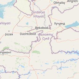
Geography guide, regional context, and park location map for Zaamin National Park

Zaamin National Park park geography, regions, and map view in Uzbekistan
Understand where Zaamin National Park sits in Uzbekistan through a broader geographic reading of the surrounding landscape, nearby location context, and its mapped position within the national park landscape.

How Zaamin National Park fits into Uzbekistan

Uzbekistan is a doubly landlocked country in Central Asia, bordered by Kazakhstan, Kyrgyzstan, Tajikistan, Afghanistan, and Turkmenistan. It is the most populous country in Central Asia, with Tashkent as its capital and largest city. The population is predominantly Uzbek-speaking and Sunni Muslim.

Wider geography shaping Zaamin National Park in Uzbekistan

Uzbekistan is located in Central Asia, bordered by Kazakhstan to the north, Kyrgyzstan to the northeast, Tajikistan to the southeast, Afghanistan to the south, and Turkmenistan to the southwest. The terrain includes mountains in the east and southeast, valleys, and vast desert areas. As a doubly landlocked country, it has no direct access to any sea.

Map view of Zaamin National Park

Use this park location map to pinpoint Zaamin National Park in Uzbekistan, understand its exact geographic position, and read its mapped placement within the surrounding landscape more clearly.

Pigeon | © OpenStreetMap contributors

Location context for Zaamin National Park

Jizzakh Region
Park atlas

Trace regional park geography and protected landscapes adjacent to Zaamin National Park.

Discover Nearby National Parks and Protected Areas Beyond Zaamin National Park's Turkestan Range
Continue park discovery by exploring national parks and protected areas near Zaamin National Park, tracing diverse mountain landscapes and ecological zones across Uzbekistan and Central Asia. Compare unique protected area characteristics, map regional park geography, and understand broader conservation efforts within this expansive atlas.
Watercolor painting of a landscape featuring green hills, grassy foreground, and distant mountains under a soft sky
National parkSouth Kazakhstan Region

Sayram-Ugam National Park: Protected Landscape and Geographic Context in South Kazakhstan

Explore dramatic alpine terrain and ancient juniper forests.

Delve into Sayram-Ugam National Park, a protected national park situated in the South Kazakhstan Region. This expansive area showcases striking mountain topography with seven natural altitude zones, from mountain steppe to permanent snowfields. It is distinguished by its vast juniper forests and serves as a crucial conservation site for wild fruit and nut tree genetic diversity, offering a unique lens for understanding Central Asian mountain ecology and landscape context.

Area
1,490 km²
Established
2007
IUCN
II
Relief
Mountain
National parkAfghanistan

Wakhan National Park: Afghanistan's Protected Landscape for Geographic Atlas Exploration

Mapped boundaries and regional terrain context.

Wakhan National Park is a designated national park in Afghanistan, offering critical insights into the country's rugged, mountainous geography. This page provides an atlas-level view of its protected landscape, detailing its geographic scope and mapped boundaries. Explore Wakhan National Park to understand its role within the broader regional context of Central and South Asia's natural terrain.

Area
10,910.1 km²
Established
2014
IUCN
II
Relief
Mountain
National parkAfghanistan

Nuristan National Park: Afghanistan National Park Protected Landscape

Mapped geography and regional terrain context

Explore Nuristan National Park, an important national park within Afghanistan. This protected area offers insights into the country's mountainous geography and its conservation landscape. Understand its mapped boundaries and its role within the broader regional context for atlas-driven discovery.

Area
5,733.07 km²
Established
2020
IUCN
II
Relief
Mountain
National parkKhyber Pakhtunkhwa

Broghil Valley National Park: High-Altitude Protected Landscape and Alpine Wilderness in Pakistan

Explore mapped terrain with glacial lakes and diverse mountain ecosystems.

Broghil Valley National Park, a national park in Pakistan's Khyber Pakhtunkhwa province, is a vast high-altitude wilderness defined by its dramatic glacial topography, numerous freshwater lakes, and vital peatland ecosystems. Situated near the Afghanistan border, this protected area offers an exceptional landscape for exploring remote mountain biodiversity and understanding the geography of Pakistan's northern frontier. Its unique terrain provides critical habitat within the Central Asian mountain range.

Area
1,348 km²
Established
2010
IUCN
II
Relief
Mountain
National parkGilgit-Baltistan

Qurumbar National Park: Pakistan's High-Altitude Protected Landscape and Geographic Atlas Point

Explore mapped alpine terrain, glacial features, and vital wildlife corridors.

Qurumbar National Park, situated in the rugged terrain of Gilgit-Baltistan, Pakistan, offers an unparalleled glimpse into a high-altitude protected landscape. This national park is defined by its dramatic alpine valleys, glacial features, and significant ecological value. As a key atlas point, it showcases the convergence of major Asian mountain systems and provides critical habitat for iconic mountain wildlife within its mapped boundaries.

Area
738 km²
Established
2011
IUCN
II
Relief
Mountain
National parkHunza District

Khunjerab National Park: Pakistan's High-Altitude Protected Landscape and Alpine Terrain

Discover dramatic Karakoram geography, wildlife habitats, and transboundary conservation.

Khunjerab National Park stands as a premier example of a high-altitude protected area, situated in Pakistan's Hunza District. This national park covers an immense territory within the Karakoram range, largely exceeding 4,000 meters. It provides a vital protected landscape for unique alpine wildlife, including critically endangered Marco Polo sheep and snow leopards, and functions as a critical transboundary conservation corridor. Explore the rugged terrain, glacial valleys, and dramatic mountain vistas that define this significant conservation area.

Area
2,269.13 km²
Established
1975
IUCN
II
Visitors
250K annual
National parkAzad Jammu and Kashmir

Machiara National Park: A Protected National Park in Pakistan's Himalayas

Explore mapped terrain and mountain biodiversity.

Machiara National Park, located in Azad Jammu and Kashmir, Pakistan, is a designated national park preserving unique Himalayan ecosystems. This atlas-focused exploration details the park's protected landscape, encompassing steep slopes, forested ridges, and varied terrain. Discover its significance for wildlife conservation and its position within the broader regional geography, offering a clear view of its mapped natural features.

Area
135.33 km²
Established
1996
IUCN
II
Relief
Mountain
National parkGilgit-Baltistan

Nanga Parbat National Park: Protected Himalayan Landscape and Geographic Atlas

Explore mapped boundaries and alpine terrain in Gilgit-Baltistan.

Nanga Parbat National Park is a vast protected area defined by its spectacular Himalayan setting and dramatic alpine geography within Gilgit-Baltistan, Pakistan. As a national park, it safeguards the immense Nanga Parbat massif, its surrounding glaciers, and diverse altitudinal landscapes. This page offers an atlas perspective for understanding the park's geographic scope, its mapped natural features, and its significance as a protected mountain wilderness.

Area
1,785.61 km²
Established
2021
IUCN
II
Relief
Mountain

Common questions about visiting, size, designation, and location context for Zaamin National Park

Zaamin National Park FAQs for park facts, access, geography, and protected area context
Find quick answers about Zaamin National Park, including protected-area facts, park geography, trail and visitor context, and how the park fits into its surrounding country and regional landscape.
MoriAtlas Explorer

Continue Your Protected Areas Search Across the Global Atlas

Deepen your exploration by continuing the structured search for national parks and protected areas worldwide. Utilize the comprehensive filtering capabilities to compare different conservation landscapes and refine your understanding of global park geography. Discover more about the distribution and characteristics of protected natural areas.

Global natural geography