

Mori Atlas logo
National parkZembra National Park

Discover the mapped boundaries and diverse ecosystems of this vital Mediterranean island protected area.

Zembra National Park: Tunisia's Pristine Island Protected Landscape and National Park Geography

Zembra National Park represents a significant protected natural area located on a mountainous Mediterranean island within Tunisia's Gulf of Tunis. This national park designation encompasses the entire island and its surrounding marine waters, establishing a critical unit for conserving unique terrestrial and coastal ecosystems. The park is a crucial refuge within the Mediterranean basin, serving as a vibrant center for island biogeography and conservation biology, offering a distinct geographic context for exploration.

Mediterranean islandsBird conservationEndemic speciesMarine protected areaSeabird coloniesMediterranean maquis

Zembra National Park

National park

Park overview

Structured park overview, official facts, and landscape profile for Zembra National Park

Zembra National Park park facts, protected area profile, and essential visitor context

Review the core facts for Zembra National Park, including designation, size, terrain, visitor scale, habitats, and operating context in one park-focused overview.

About Zembra National Park

Zembra National Park represents one of Tunisia's most important conservation achievements, established to protect the exceptional natural values of Zembra Island. The island rises dramatically from the Mediterranean Sea, presenting a landscape of dramatic cliffs, rocky slopes, and hidden valleys that have remained relatively undisturbed by human activity. The park's designation encompasses not only the terrestrial environment but also the surrounding marine waters, acknowledging that the island's ecological integrity depends on the health of its adjacent sea. Visitors to the park, though limited in number due to conservation protocols, experience a landscape that remains close to its natural state, with Mediterranean maquis dominating the vegetation and bird colonies nesting on the sheer coastal cliffs. The park serves multiple conservation functions, protecting endemic species, preserving genetic diversity, and maintaining ecological processes that have shaped the island over millennia.

Quick facts and research context for Zembra National Park

Zembra National Park occupies a Mediterranean island in the Gulf of Tunis, approximately 25 kilometers northeast of Tunisia's capital city. The island features rugged terrain characterized by steep limestone cliffs, rocky ridges, and Mediterranean maquis vegetation. The park's isolation has allowed unique ecosystems to develop, supporting several endemic species found nowhere else on Earth. The surrounding marine environment includes important Posidonia oceanica seagrass beds and diverse fish communities.

Park context

Deeper park guide and search-rich context for Zembra National Park

Zembra National Park history, landscape, wildlife, and travel context

Explore Zembra National Park through its history, landscape character, ecosystems, wildlife, conservation priorities, cultural context, and seasonal travel timing in a structured park guide built for atlas discovery and search intent.

Why Zembra National Park stands out

Zembra National Park is best known for its exceptional birdlife, particularly as a nesting site for the endangered Eleonora's falcon and a critical waypoint for migratory birds traversing the Mediterranean. The island's cliffs support significant populations of seabirds, while its isolated position makes it a biodiversity hotspot in the region. The park is also recognized for its preserved Mediterranean maquis ecosystem and the presence of several plant species endemic to the island.

Zembra National Park history and protected-area timeline

Zembra Island has long been recognized for its ecological significance, with historical records indicating that local communities understood the island's unique biodiversity long before formal protection measures were implemented. The establishment of Zembra National Park reflected Tunisia's broader commitment to conservation during the late twentieth and early twenty-first centuries. The park was designated as part of a network of protected areas aimed at preserving the country's most significant natural habitats and species. Prior to national park status, the island benefited from various protection regimes that limited development and preserved its wild character.

Zembra National Park landscape and geographic character

Zembra Island presents a dramatic Mediterranean landscape dominated by limestone formations that create a rugged, mountainous terrain rising sharply from the sea. The island's topography features steep coastal cliffs that plunge into the Mediterranean, interspersed with smaller coves and rocky shorelines. Inland, the terrain transitions to rocky slopes covered in Mediterranean maquis, with occasional flat areas supporting more diverse vegetation. The island lacks permanent freshwater streams, with rainfall instead collecting in seasonal pools that provide vital water sources for wildlife during the drier months. The surrounding marine environment includes clear waters with extensive seagrass meadows and rocky substrates supporting diverse marine life.

Zembra National Park ecosystems, habitats, and plant life

The ecological character of Zembra National Park reflects its position as an isolated Mediterranean island with limited human disturbance. The terrestrial vegetation is dominated by Mediterranean maquis, a dense shrubland community adapted to the region's climate and featuring species such as juniper, myrtle, and various aromatic herbs. The island supports several plant species found nowhere else in the world, a testament to its long-term isolation and unique ecological conditions. The marine environment surrounding the island includes important Posidonia oceanica seagrass beds, which are critical for marine biodiversity and ecosystem function in the Mediterranean. These underwater meadows provide habitat for numerous fish species and contribute to water clarity and quality.

Zembra National Park wildlife and species highlights

Zembra National Park supports remarkable wildlife populations, with birds being the most notable group. The island serves as a significant breeding site for Eleonora's falcon, a species that winters in Madagascar and breeds in Mediterranean islands during the summer months. The coastal cliffs provide nesting habitat for various seabird species, while the island's position along major migratory routes makes it an important stopover for birds traveling between Europe and Africa. The terrestrial fauna includes several reptile species adapted to the Mediterranean environment, as well as small mammals that have colonized the island over time. The surrounding marine waters support diverse fish communities and occasional marine mammals.

Zembra National Park conservation status and protection priorities

The establishment of Zembra National Park reflects recognition of the island's exceptional conservation value, both as a site for endemic species and as a living example of Mediterranean island ecosystems. The park's protected status helps ensure that development pressures remain minimal and that ecological processes continue to function naturally. Conservation efforts focus on maintaining the island's ecological integrity by managing visitor access and monitoring wildlife populations. The protection of surrounding marine waters is equally important, as the health of terrestrial and marine ecosystems is interconnected. The park contributes to regional conservation goals by providing habitat for species that depend on Mediterranean island environments.

Zembra National Park cultural meaning and human context

Zembra Island has been part of the regional maritime cultural landscape for centuries, with historical connections to coastal communities in Tunisia. While the island has no permanent human population today, historical references indicate that it was used for various purposes over the centuries, including as a reference point for navigation in the Gulf of Tunis. The island's name and its place in local geography reflect the long relationship between human communities and this Mediterranean landscape. The park's establishment has reinforced the island's conservation identity while recognizing its place in the broader cultural geography of the Tunisian coast.

Top sights and standout views in Zembra National Park

The most outstanding highlights of Zembra National Park include its dramatic cliff landscapes that provide breathtaking views of the Mediterranean, its exceptional bird populations including breeding Eleonora's falcons, the presence of endemic plant species found nowhere else on Earth, and the opportunity to experience a Mediterranean island ecosystem in a relatively pristine state. The underwater marine environment offers additional appeal, with clear waters and seagrass meadows visible from the island's shores. The sense of isolation and wilderness, rare in the heavily populated Mediterranean region, makes the park particularly valuable for those seeking to experience natural environments.

Best time to visit Zembra National Park

The optimal time to experience Zembra National Park corresponds with the bird breeding season, when the island's wildlife activity is most observable and the weather conditions are comfortable for outdoor exploration. Spring and early summer bring Migratory birds and breeding seabirds, creating opportunities for wildlife observation. The Mediterranean climate means that autumn and winter months can also be pleasant, though conditions may be cooler and some species less active. The park's accessibility may vary with seasonal weather patterns affecting marine conditions, and visitors should consult current conditions before planning trips.
Monthly climate preview

Trace long term temperature and precipitation patterns across representative coordinates

Zembra National Park Climate Normals and Monthly Weather Statistics

Representative baseline coordinates for Zembra National Park record structured monthly averages spanning low winter temperatures through warm summer peaks alongside shifting precipitation rates. Reviewing the complete twelve month climatology profile clarifies long term environmental trends at this protected location.
Annual mean19 °C
12 °C27 °C
Jan13°
Feb12°
Mar14°
Apr16°
May19°
Jun23°
Jul26°
Aug27°
Sep25°
Oct22°
Nov18°
Dec14°
Warmest month
August

27 °C

Coolest month
February

12.5 °C

Wettest month
September

2.2 mm/day

Driest month
July

0.2 mm/day

Park location guide

Geography guide, regional context, and park location map for Zembra National Park

Zembra National Park park geography, regions, and map view in Tunisia

Understand where Zembra National Park sits in Tunisia through a broader geographic reading of the surrounding landscape, nearby location context, and its mapped position within the national park landscape.

How Zembra National Park fits into Tunisia

Tunisia is a Maghreb country in North Africa with a Mediterranean coastline, bordered by Algeria and Libya. The country features the ancient ruins of Carthage, the Great Mosque of Kairouan, and portions of the Atlas Mountains and Sahara Desert. With a population of approximately 12 million, Tunisia operates as a unitary presidential republic with Arabic as the official language.

Wider geography shaping Zembra National Park in Tunisia

Tunisia occupies 163,610 km² in North Africa, bordering Algeria to the west and southwest, Libya to the southeast, and the Mediterranean Sea to the north and east. The country features the eastern end of the Atlas Mountains in the north and extends into the northern Sahara Desert in the south. Its 1,300 km of coastline runs along the Mediterranean Basin. Africa's northernmost point, Cape Angela, is located in Tunisia.

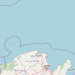
Map view of Zembra National Park

Use this park location map to pinpoint Zembra National Park in Tunisia, understand its exact geographic position, and read its mapped placement within the surrounding landscape more clearly.

Pigeon | © OpenStreetMap contributors
Park atlas

Map the geographic spread of protected island and coastal areas, comparing conservation landscapes in the broader Mediterranean basin.

Explore Related National Parks and Protected Areas near Zembra National Park and the Gulf of Tunis

After exploring Zembra National Park, browse other protected areas within Tunisia or the wider Mediterranean, identifying diverse island and coastal conservation units. This comparative view allows you to trace regional protected landscapes, examine different ecosystem types, and understand the geographic spread of critical habitats beyond Zembra Island.
National parkTunisia
About 62 km away#1 closest

Southwest

Boukornine National Park: A Protected Mediterranean Mountain Landscape in Tunisia

Explore its mapped terrain and unique protected ecosystem.

Boukornine National Park in Tunisia represents a significant protected landscape, notable for its central granite peak, Jebel Boukornine, which rises sharply above the surrounding coastal plains. This national park, covering approximately 1,939 hectares, preserves a distinctive Mediterranean mountain ecosystem. Its rugged terrain, rocky slopes, and the presence of Aïn Zargua spring support a unique concentration of species, including notable flora and fauna. Understanding Boukornine National Park provides insight into the regional geography and the importance of conserving these mountainous protected areas within Tunisia.

Area
19.39 km²
Established
1987
IUCN
II
Relief
Mountain
National parkTunisia
About 93 km away#2 closest

West

Ichkeul National Park: Tunisia's Key Protected Landscape for Geographic Discovery

Explore the mapped geography and regional context of this Tunisian national park.

Ichkeul National Park is a crucial protected area located in Tunisia, offering a distinct focal point for geographic exploration and atlas-based understanding. This park's mapped boundaries and protected status are central to appreciating its role within Tunisia's natural landscapes and the wider North African region. Through structured data and detailed geographic context, users can gain insight into Ichkeul National Park's unique environmental identity and its significance as a protected natural resource.

Watercolor painting of a landscape with rolling hills, pink wildflowers, and scattered trees
National parkItaly
About 106 km away#3 closest

East

Pantelleria National Park: A Protected Landscape within Italy's Atlas

Mapped boundaries and regional geographic context.

Pantelleria National Park is a designated national park in Italy offering a distinct protected landscape for exploration. This page provides essential geographic context, highlighting the park's mapped boundaries and its significance within the regional atlas. Understand the terrain and protected land features that define this important natural area.

Area
66.4 km²
Established
2016
IUCN
II
Relief
Highland
National parkBizerte Governorate
About 163 km away#4 closest

West

Jebel Chitana-Cap Négro National Park: National Park Protected Area & Landscape Identity

Explore the mapped geography of Jebel Chitana-Cap Négro National Park.

As a designated national park, Jebel Chitana-Cap Négro National Park represents a key protected area for understanding the regional geography of Bizerte Governorate. This entry provides structured information focused on the park's geographic scope, its mapped boundaries, and its significance as a protected landscape. It is designed for users seeking detailed, atlas-style context on Jebel Chitana-Cap Négro National Park's natural setting and its place within Tunisia's protected lands network.

Area
101.2 km²
Established
2010
Relief
Mountain
Scope
Terrestrial
National parkTunisia
About 172 km away#5 closest

West

Oued Zeen National Park: Tunisia's National Park Entry for Geographic and Landscape Atlas Exploration

Explore the mapped protected area and regional geography of Oued Zeen National Park.

Oued Zeen National Park is a designated national park in Tunisia, offering a crucial point for geographic exploration within the country's atlas. This page details its protected landscape identity, contributing to a structured understanding of regional natural areas and park boundaries. Users can examine its geographic setting and landscape context to deepen their appreciation of Tunisia's protected lands.

Area
67 km²
Established
2010
Scope
Terrestrial
Water
Major water bodies
National parkTunisia
About 174 km away#6 closest

Southwest

Jebel Serj National Park: Central Tunisia's Distinctive Mountain Protected Area

Explore its terrain and protected landscape context.

Jebel Serj National Park, established in 2010, safeguards a significant mountainous territory in central Tunisia, distinguishing itself from the broader semi-arid plains. This protected landscape showcases the Djebel Serj massif, a unique topographical feature that serves as an ecological bridge between Tunisia's northern and southern regions. Users exploring this page can gain an atlas-level understanding of the park's mapped boundaries, its geological character, and its contribution to the conservation of representative natural diversity within North Africa's transitional ecosystems.

Area
17.2 km²
Established
2010
IUCN
II
Scope
Terrestrial
National parkEl Tarf Province
About 192 km away#7 closest

West

El Kala National Park: Protected Wetlands and Barbary Stag Habitat

Explore its mapped geography and vital ecosystem context.

El Kala National Park represents a crucial protected landscape within El Tarf Province, Algeria, recognized internationally for its extensive Mediterranean wetlands and rich biodiversity. This national park is a vital ecological zone, comprising six major lakes and a significant stretch of coastline, offering a unique mosaic of aquatic and terrestrial environments. Its role as a sanctuary for the Barbary stag and migratory birds highlights its importance in regional conservation efforts. Exploring El Kala National Park provides insight into the mapped terrain, protected boundaries, and distinct geographic features that define this significant North African natural area.

Area
764 km²
Established
1993
IUCN
II
Visitors
30K annual
National parkJendouba Governorate
About 196 km away#8 closest

West

El Feidja National Park: National Park Mapping and Protected Landscape Discovery

Explore geographic context within Jendouba Governorate.

Gain a clear understanding of El Feidja National Park's protected status and its geographic footprint. This page offers detailed insights into the park's mapped boundaries and landscape characteristics, situated within the Jendouba Governorate. It serves as a primary resource for atlas exploration, highlighting the natural terrain and regional significance of this Tunisian national park.

Area
27.65 km²
Established
1990
IUCN
II
Relief
Mountain

Common questions about visiting, size, designation, and location context for Zembra National Park

Zembra National Park FAQs for park facts, access, geography, and protected area context

Find quick answers about Zembra National Park, including protected-area facts, park geography, trail and visitor context, and how the park fits into its surrounding country and regional landscape.
MoriAtlas Explorer

Continue Your Protected Areas Search Across the Global Atlas

Deepen your exploration by continuing the structured search for national parks and protected areas worldwide. Utilize the comprehensive filtering capabilities to compare different conservation landscapes and refine your understanding of global park geography. Discover more about the distribution and characteristics of protected natural areas.

Global natural geography

