
Mori Atlas logo
Protected areaZirbitzkogel

A comprehensive look at the high mountain geography, subalpine vegetation zones, and summit plateau character.

Zirbitzkogel Protected Area: Mapping the Alpine Landscapes and Glacial Terrain of the Seetal Alps

Zirbitzkogel rises as the defining summit of the Seetal Alps in the Austrian state of Styria, presenting a distinct alpine character shaped by ancient glacial movements and crystalline rock formations. This protected area spans a mosaic of environments, from dense lower spruce forests to elevated plateaus of sedge grasslands and lichen-covered wind-exposed zones. The landscape also hosts unique ecological features, including spring-rich terrain and glacial tarns, marking the region as a significant site for high-mountain natural observation and geographic study.

alpine mountainStyriaAustriaSeetal AlpsNatura 2000subalpine forest
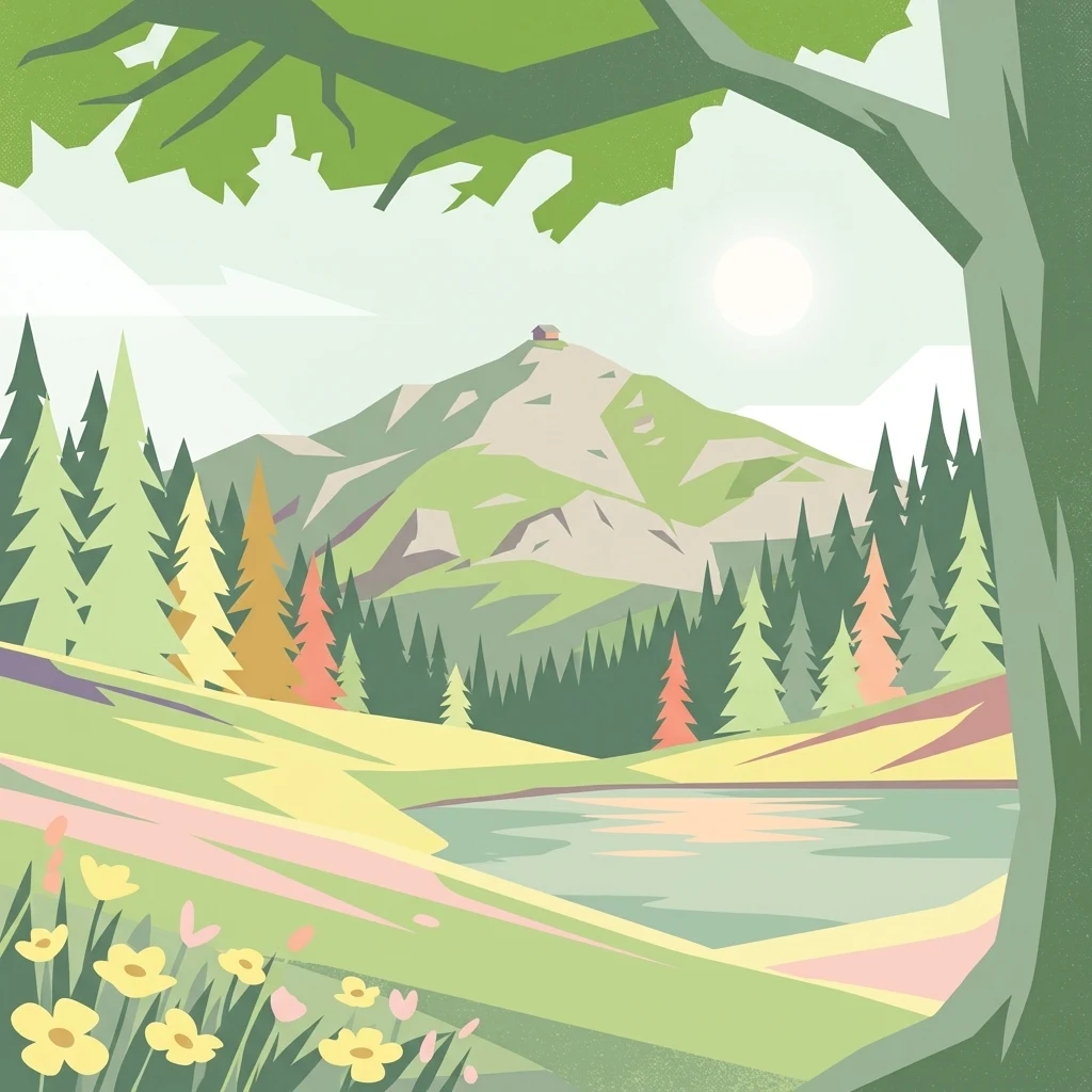
A graphic illustration of Zirbitzkogel, showing yellow wildflowers in the foreground, a lake and pine forest in the midground, and a mountain peak with a small structure on top in the background.

Zirbitzkogel

Protected area

Park overview

Structured park overview, official facts, and landscape profile for Zirbitzkogel

Zirbitzkogel park facts, protected area profile, and essential visitor context

Review the core facts for Zirbitzkogel, including designation, size, terrain, visitor scale, habitats, and operating context in one park-focused overview.

About Zirbitzkogel

Zirbitzkogel is a prominent peak in the Seetal Alps of Styria, Austria, and the highest point of that range at 2,396 metres above sea level. It lies south of the upper Mur valley, near the Styria-Carinthia border, and forms a notable geographical landmark in the eastern Alps. From its summit, the Lavant river, a left tributary of the Drau, takes its source on the southern slopes, linking the mountain directly to the broader Alpine hydrology of the region.

The mountain's identity is shaped by both geology and biology. Its summit block consists of crystalline rock, dominated by slate, gneiss and granite, while its visible relief was carved by ice age glaciers and subsequent slope movement. Despite a comparatively modest absolute height, the peak displays an unmistakably alpine character. Small tarns, including the Winterleitenseen, occupy the spring-rich upper catchment, and the terrain transitions through clear vegetation zones from dense spruce forest up through the subalpine belt.

Culturally and recreationally, Zirbitzkogel stands out as a well-developed hiking destination. The Zirbitzkogelhaus sits just below the summit, with additional huts along the ascent routes and St. Anna, St. Wolfgang bei Obdach and Neumarkt serving as main starting points. A long-distance route, the Eisenwurzenweg, also crosses the mountain. Above all, the Zirbitzkogel is valued today as a Natura 2000 protected landscape, recognised for its mix of alpine habitats, its historical ornithological importance, and its quiet but striking presence within the Seetal Alps.

Protection and recognition

Documented terrestrial protection scope, designation history, and Natura 2000 records

Zirbitzkogel Protection Status and International Recognition Data

Zirbitzkogel holds documented terrestrial protection status established in 2006 alongside official Natura 2000 recognition sources. Official designation history and management scope provide clear baseline facts for conservation tracking.

International recognition

Protection details

Protection scope
Terrestrial
Designated year
2006
Transboundary protection
No
Park context

Deeper park guide and search-rich context for Zirbitzkogel

Zirbitzkogel history, landscape, wildlife, and travel context

Explore Zirbitzkogel through its history, landscape character, ecosystems, wildlife, conservation priorities, cultural context, and seasonal travel timing in a structured park guide built for atlas discovery and search intent.

Why Zirbitzkogel stands out

Zirbitzkogel is best known for being the highest point of the Seetal Alps, with a distinctly high-mountain character despite a moderate elevation. Its summit area combines ragged sedge grasslands, plateau-like terrain, and stands of spruce, larch and Swiss pine that mark the subalpine treeline. The mountain is also recognized within conservation circles for once hosting one of Austria's few regular breeding sites for the Eurasian dotterel, along with a population of rare alpine butterflies that includes the endemic species Elophos zirbitzensis.
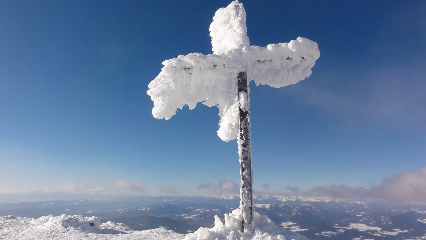
A snow-covered metal summit cross stands against a deep blue sky at the top of a mountain, overlooking a vast winter landscape.
The summit cross of Zirbitzkogel covered in rime ice during winter.

Zirbitzkogel landscape and geographic character

The landscape of Zirbitzkogel is defined by crystalline alpine geology. Slate, gneiss and granite dominate the summit block, while ice age glaciers and subsequent slope movements have shaped a relief that clearly reads as high mountain, even though the absolute elevation is moderate by Alpine standards. Small glacial features, including tarns such as the two Winterleitenseen, occupy the spring-rich upper slopes.

Vegetation zones on the mountain are unusually distinct. Dense spruce forest cloaks the lower slopes up to the subalpine limit, where it thins into open stands of spruce, larch and Swiss pine. Higher again, the terrain flattens into broad, almost level plateaus covered by ragged sedge grasslands. Wind-exposed sites near the summit shift character again, giving way to Alpine Azalea and a ground layer of various lichens, creating a mosaic of alpine micro-landscapes within a relatively compact area.
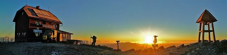
Panoramic view of a mountain summit at sunrise, featuring a wooden hut on the left, a hiker in silhouette, and a small wooden bell tower on the right, with a bright sun rising over distant peaks.
Sunrise at the summit of Zirbitzkogel, showing the mountain hut and lookout.

Zirbitzkogel wildlife and species highlights

Zirbitzkogel is particularly known for its birdlife. The summit region became famous among ornithologists as a breeding habitat for the Eurasian dotterel, with a few pairs nesting there almost every year until 1995. Although no further broods have been confirmed since then, individual migrants and roosting birds continue to be observed, keeping the site on the radar of alpine bird researchers.

The mountain is also important for invertebrate diversity. Butterfly researchers have documented several very rare species in the Zirbitzkogel area, including Elophos zirbitzensis, an endemic moth found only in this part of the Alps. Together, these features give the park-level landscape around the peak a recognized significance for alpine fauna beyond its more obvious scenic value.
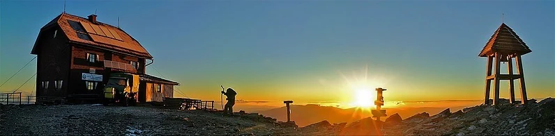
A panoramic view of a mountain refuge and a small wooden bell structure at the summit of Zirbitzkogel during sunrise.
Sunrise at the Zirbitzkogel mountain refuge.

Zirbitzkogel conservation status and protection priorities

The wider Zirbitzkogel region was incorporated into the Natura 2000 network and has been formally designated a European protected area since May 2006. This status reflects the value of its mosaic of spruce forest, subalpine larch-Swiss pine woodland, alpine sedge grasslands, tarns and exposed ridge habitats as a coherent alpine ecosystem.

Conservation interest in the area has been driven not only by habitat diversity but also by species of European importance. The mountain's historical significance as a dotterel breeding site and its population of endemic alpine butterflies, including Elophos zirbitzensis, underline the broader ecological relevance of protecting the Seetal Alps landscape around Zirbitzkogel.

Zirbitzkogel cultural meaning and human context

The name Zirbitzkogel has local folk-etymological roots that are themselves part of the area's cultural identity. Rather than deriving from the Swiss pine trees that populate parts of the slopes, the name is linked to a Slavic-rooted word associated with the red blooms of the alpenrose, locally called Almrausch, which grows widely across the mountain's pastures.

The region also has a strong tradition of alpine hiking culture. Zirbitzkogel is served by a network of huts, including the Zirbitzkogelhaus just below the summit, the Sabathy Hut, the Waldheim Hut, the Tonner Hut and the Winterleiten Hut, and is crossed by the long-distance Eisenwurzenweg trail. An annual summer mountain run from Sankt Anna am Lavantegg up to the Schutzhaus reflects the peak's place in the local sporting and outdoor heritage.
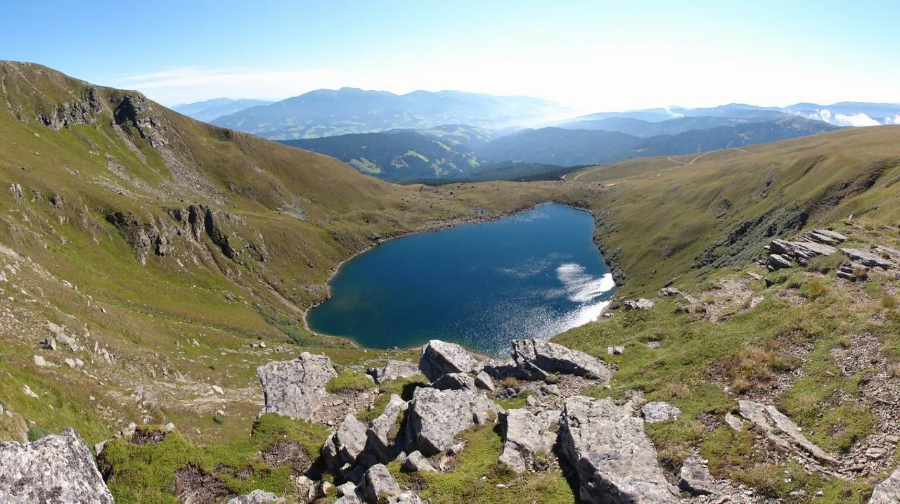
A high-angle view looking down into a mountain cirque containing a deep blue lake, surrounded by grassy slopes and rocky outcrops.
The glacial Wildsee lake situated within the alpine terrain of Zirbitzkogel.

Top sights and standout views in Zirbitzkogel

Zirbitzkogel's strongest highlights include its status as the highest point of the Seetal Alps, the unusually clear high-mountain vegetation zonation from spruce forest to alpine sedge grasslands, and the small glacial tarns such as the Winterleitenseen in its spring-rich upper slopes.

Equally notable is the mountain's ecological profile, from its historic dotterel breeding sites to rare endemic butterflies, and its formal recognition as a Natura 2000 European protected area, all combined with a well-established network of huts and long-distance trails that make its alpine character unusually accessible.
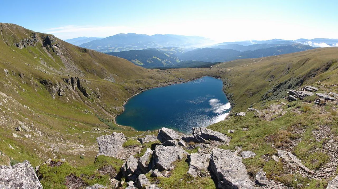
High angle panoramic view looking down into a deep, circular, blue glacial lake surrounded by grassy, rocky slopes and mountain ridges under a bright, clear sky.
The glacial Wildsee lake nestled in the Seetal Alps at Zirbitzkogel.

Best time to visit Zirbitzkogel

Zirbitzkogel is at its most rewarding in the warmer months, when the alpine meadows around the summit come into bloom and the red alpenrose that gives the area its cultural character is in flower. Summer and early autumn are also the seasons when the hut network and long-distance trails along the Eisenwurzenweg are most reliably accessible.

In winter the summit takes on a more austere character and the approach routes become considerably more demanding, but the snowy peak offers a very different, more austere alpine experience. Visitors interested in migratory or breeding birdlife should generally consider the late spring and summer window, when Zirbitzkogel's ornithological and butterfly interest is most active.

Monthly climate preview

Long-term representative point measurements tracking monthly temperature and precipitation rhythms

Zirbitzkogel Climate Normals and Measured Annual Temperature Patterns

Representative coordinates record long-term temperature swings from sub-zero winter minimums to mild summer maximums alongside varying daily precipitation rates. Examining the full twelve-month climate profile reveals complete monthly averages across the entire annual cycle.
Annual mean5 °C
-5 °C16 °C
Jan-5°
Feb-4°
Mar
Apr
May10°
Jun14°
Jul16°
Aug15°
Sep11°
Oct
Nov
Dec-4°
Warmest month
July

15.6 °C

Coolest month
January

-4.6 °C

Wettest month
July

4.6 mm/day

Driest month
January

1.2 mm/day

Park location guide

Geography guide, regional context, and park location map for Zirbitzkogel

Zirbitzkogel park geography, regions, and map view in Austria

Understand where Zirbitzkogel sits in Austria through a broader geographic reading of the surrounding landscape, nearby location context, and its mapped position within the national park landscape.

How Zirbitzkogel fits into Austria

Austria is a landlocked country in Central Europe, bordered by Germany, Czech Republic, Slovakia, Hungary, Slovenia, Italy, Switzerland, and Liechtenstein. The country is a federal semi-presessional republic composed of nine states, with Vienna as its capital and largest city. It has a population of approximately 9.1 million people.

Wider geography shaping Zirbitzkogel in Austria

Austria is located in Central Europe, lying in the Eastern Alps. It is bordered by Germany and Czech Republic to the north, Slovakia to the northeast, Hungary to the east, Slovenia and Italy to the south, and Switzerland and Liechtenstein to the west.

Map view of Zirbitzkogel

Use this park location map to pinpoint Zirbitzkogel in Austria, understand its exact geographic position, and read its mapped placement within the surrounding landscape more clearly.

Pigeon | © OpenStreetMap contributors

Location context for Zirbitzkogel

Styria
Recorded earthquake history

Explore the Historical Earthquake Catalogue for Zirbitzkogel

Access the complete collection of recorded seismic events associated with the Zirbitzkogel landscape. MoriAtlas provides a clear, data-driven view of historical activity near the Seetal Alps to support your geographic and geological research.

Zirbitzkogel Earthquake History

Catalogued events

23 events

Strongest magnitude

Magnitude 4.7

Most recent event

Dec 29, 2008

This history includes earthquakes recorded inside the park or within 50 km of its borders

Visual reference guide to high-mountain terrain, glacial tarns, and protected habitats

Zirbitzkogel Photos and Alpine Landscape Scenery

Visual documentation captures the high-mountain terrain, subalpine forests, and glacial tarns defining the protected landscape around Zirbitzkogel. Examining these environmental details provides a clear reference for understanding local vegetation zones, alpine geology, and protected ecosystems.

A snow-covered metal summit cross stands against a deep blue sky at the top of a mountain, overlooking a vast winter landscape.

Panoramic view of a mountain summit at sunrise, featuring a wooden hut on the left, a hiker in silhouette, and a small wooden bell tower on the right, with a bright sun rising over distant peaks.

A panoramic view of a mountain refuge and a small wooden bell structure at the summit of Zirbitzkogel during sunrise.

A thick, rime-covered mountain summit cross stands against a clear blue sky, overlooking a snowy mountain landscape.

A high-angle view looking down into a mountain cirque containing a deep blue lake, surrounded by grassy slopes and rocky outcrops.

High angle panoramic view looking down into a deep, circular, blue glacial lake surrounded by grassy, rocky slopes and mountain ridges under a bright, clear sky.

A mountain peak with a small building on top rises above a dense forest of evergreen and golden yellow larch trees.

Panoramic landscape view showing a grassy alpine slope in the foreground, rolling green hills and forests in the midground, and the broad Zirbitzkogel mountain range under a cloudy sky.

A green alpine meadow leading up to a distant mountain peak against a clear blue sky, framed by the dark silhouette of a tree branch in the foreground.

A close-up of yellow alpine wildflowers in the foreground with a blue mountain lake and green grassy slopes in the background.

A close up view of yellow alpine flowers in the foreground with a blue alpine lake and grassy mountain slopes in the background.

Panoramic landscape view of the Zirbitzkogel mountain peak rising above green rolling hills and evergreen forests under a blue, partly cloudy sky.

Park atlas

Compare adjacent alpine terrain and regional conservation landscapes

Parks Near Zirbitzkogel and Surrounding Seetal Alps Protected Areas

Browse protected areas and high mountain reserves located close to Zirbitzkogel in the Austrian Alps. Comparing adjacent regional geography reveals broader patterns in subalpine forests, glacial tarns, and crystalline mountain relief.
National parkStyria
48 km away#1 closest

North

Gesäuse National Park: Detailed Protected Landscape and Alpine Geography in Styria

Explore Austria's dramatic river gorge and rugged peaks.

Gesäuse National Park in Styria represents a significant alpine protected area, characterized by the striking Enns river gorge cutting through the Gesäuseberge. This national park offers a unique geographic context, showcasing steep limestone peaks, dramatic rock faces, and a rich hydrological network. Discover the mapped boundaries and protected landscape of one of Austria's most visually striking natural passages, ideal for detailed atlas exploration and understanding alpine conservation.

Area
110 km²
Established
2002
IUCN
II
Relief
Mountain
A horizontal watercolor painting showing a soft mountain range with green forests, a winding river valley, and wildflowers in the foreground.
Protected areaAustria
About 53 km away#2 closest

South

Geopark Karawanken: Alpine Protected Landscape and Tectonic Geography in Austria

A cross-border protected area defined by tectonic uplift and deep alpine valleys.

Geopark Karawanken showcases a profound geological record formed by tectonic plate convergence. The protected area features sharp mountain massifs, subterranean karst systems, and deep-cut gorges that reveal the underlying structural complexity of the alpine range, offering a clear view of how tectonic forces shape regional geography.

Area
1,067 km²
Established
2013
Relief
Mountain
Climate
Alpine
A watercolor painting showing a wide, panoramic view of rolling, grassy mountain slopes with soft pastel colors and small evergreen trees.
Protected landscapeCarinthia
About 64 km away#3 closest

West

Nock Mountains National Park: Mapping the Rounded Alpine Summits and Glacial Terrain of Carinthia

A protected alpine landscape and UNESCO Biosphere Reserve in the Austrian Alps

Discover the geographic character of Nock Mountains National Park, where the Gurktal Alps transition into sweeping, grass-covered dome summits. This protected area offers a look at a unique Tertiary land surface that survived the last Ice Age, supporting a mosaic of larch forests, alpine pastures, and high-altitude lakes that define the regional geography of southern Austria.

Area
184 km²
Established
1987
IUCN
V
Relief
Mountain
Watercolor painting depicting layered mountain ranges, forests, and water bodies in green and pink tones
National parkUpper Austria
65 km away#4 closest

North

Kalkalpen National Park: Ancient Beech Forests and Karst Protected Landscape

Explore mapped boundaries and unique alpine terrain.

Kalkalpen National Park is a premier protected area in Upper Austria, celebrated for harboring Central Europe's largest remaining ancient beech forests and an extensive karst landscape. This designation underscores its critical role in preserving old-growth forest ecosystems and unique geological formations within the Northern Limestone Alps. Discover the mapped terrain and regional geography that define this significant natural reserve, offering a profound look into the continent's ecological history and protected natural heritage.

Area
208.25 km²
Established
1997
IUCN
II
Relief
Mountain
Watercolor illustration of a river flowing through a forested valley with mountains in the background
National parkSlovenia
78 km away#5 closest

Southwest

Triglav National Park: A Mapped Alpine Protected Landscape in Slovenia

Julian Alps geography, glacial lakes, and karst terrain.

Triglav National Park is Slovenia's premier protected area, covering 880 square kilometers of the Julian Alps. This page details its dramatic alpine geography, including Mount Triglav, glacial valleys, and significant karst features. Understand the mapped boundaries and landscape context of this national park, a key entry in the MoriAtlas geographic discovery resource for understanding protected lands.

Area
880 km²
Established
1981
IUCN
II
Visitors
1.6M annual
National parkAustria
About 79 km away#6 closest

North

Limestone Alps National Park: A National Park in Austria's Mapped Protected Landscapes

Explore protected area boundaries and regional geography.

Limestone Alps National Park represents a vital component of Austria's protected lands, contributing to the nation's atlas of natural landscapes. This page details the park's identity as a national park, focusing on its geographic scope and mapped boundaries. Users can delve into the regional context and understand the protected-area significance of Limestone Alps National Park, enriching their exploration of Austria's diverse geography.

National parkAustria
85 km away#7 closest

West

Hohe Tauern National Park: Regional Geography and Protected Alpine Mountain Terrain

Major protected area in the heart of the Austrian Alps

Hohe Tauern National Park protects a grand scale of alpine terrain, including towering summits above 3,000 meters and the longest glacial systems in the country. This atlas record provides insights into the park's vertical landscape, encompassing glacial valleys, waterfalls, and diverse ecological zones that define the High Tauern mountain range in Austria.

A soft watercolor illustration showing a panoramic view of mountain ridgelines in muted green, blue, and faint pink tones against a white background.
Nature reserveSalzkammergut
About 86 km away#8 closest

Northwest

Loser Plateau Nature Reserve: Alpine Karst Geography in the Salzkammergut Mountain Range

Protected high alpine plateau and extensive karst systems

The Loser Plateau is a distinctive high-altitude nature reserve in the Salzkammergut region of Austria. This protected area features expansive limestone pavements, complex karst sinkholes, and massive mountain crags that dominate the skyline above Lake Altaussee. It provides a unique window into high alpine geology, showcasing fossil-rich layers and an intricate network of documented cave systems that rank among the most significant in the Eastern Alps.

Area
12 km²
Relief
Mountain
Climate
Alpine
Access
Easy access

Common questions about visiting, size, designation, and location context for Zirbitzkogel

Zirbitzkogel FAQs for park facts, access, geography, and protected area context

Find quick answers about Zirbitzkogel, including protected-area facts, park geography, trail and visitor context, and how the park fits into its surrounding country and regional landscape.
MoriAtlas Explorer

Continue Your Protected Areas Search Across the Global Atlas

Deepen your exploration by continuing the structured search for national parks and protected areas worldwide. Utilize the comprehensive filtering capabilities to compare different conservation landscapes and refine your understanding of global park geography. Discover more about the distribution and characteristics of protected natural areas.

Global natural geography