
Natural springs
Park geography
A comprehensive look at the regional terrain, mountain peaks, and forest distributions.
Geography and Physical Boundaries of Appennino Lucano - Val d'Agri - Lagonegrese National Park
The geography of Appennino Lucano - Val d'Agri - Lagonegrese National Park spans 689.96 square kilometers across the Basilicata region. This protected area features complex mountain terrain and expansive temperate forests, including notable peaks like Monte Volturino and Monte Raparo. The site presents a detailed record of land boundaries, varied springs, and landscape features within its mountainous jurisdiction.
Mountain wilderness linking the Pollino and Cilento parks in the heart of Basilicata
Appennino Lucano - Val d'Agri - Lagonegrese National Park
Appennino Lucano - Val d'Agri - Lagonegrese National Park is a protected mountain landscape in the southern Italian Apennines, established in 2007 in the Basilicata region. The park spans approximately 69,000 hectares across 29 municipalities in the Province of Potenza, encompassing the Lucano Apennine range, the Val d'Agri basin, and the Lagonegrese area. This relatively young Italian national park represents one of the most significant recent additions to Italy's protected area network, protecting a rugged mountainous territory that serves as a critical ecological corridor between two major southern Italian parks: Pollino National Park to the south and Cilento and Vallo di Diano National Park to the west. The park features diverse elevation gradients, from valley bottoms along the Agri River to dramatic peaks exceeding 2,000 meters, supporting varied ecosystems and traditional rural landscapes that define the character of inland Basilicata.
- Location
- Italy
- Park type
- National park
- Established
- 2007
- Area
- 690 km²
Location overview
National and regional placement within the Basilicata territory of Italy
Appennino Lucano - Val d'Agri - Lagonegrese National Park Geographic Setting
Appennino Lucano - Val d'Agri - Lagonegrese National Park lies entirely within the Basilicata region of Italy. Administrative records confirm an inland setting with no transboundary or marine elements.
- Countries
- Italy
- Regions
- Basilicata
- Primary location
- Basilicata
- Geographic setting
- Inland
Boundary and coordinates
Exploring the 689.96 square kilometer boundary and spatial footprint
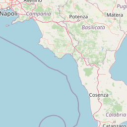
Appennino Lucano, Val d'Agri, Lagonegrese National Park Boundary Map
The interactive boundary geometry illustrates the spatial context and landscape reach of the park. Geographic datasets provide estimated values for the 689.96 square kilometer area, coordinates, and center point.
- Boundary area
- 690.4 km²
- Boundary perimeter
- 558.9 km
- Northernmost point
- 40.5858° N
- Southernmost point
- 40.0867° N
- Easternmost point
- 16.1598° E
- Westernmost point
- 15.5962° E
- Geographic centre
- 40.338° N, 15.8669° E
- North–south span
- 55.4 km
- East–west span
- 47.9 km
Terrain and natural features
Explore stored terrain classifications and recorded natural landmarks within the protected area.
Appennino Lucano - Val d'Agri - Lagonegrese National Park Terrain and Named Features
Appennino Lucano - Val d'Agri - Lagonegrese National Park features a mountain relief classification encompassing various peaks, lakes, and springs. Linked feature cards supply names, types, measurements, and spatial relationships for each recorded natural element.
Selected named natural features
Lakes
Lago Sirino
Peaks
Croce Tempone Rosso
1,321 m
Peaks
1215
Peaks
Monte Pano
1,160 m
Natural springs
fonte Capelluzzo
Environmental setting
Interpreting mountain relief, forest cover, and habitat types across protected terrain
Appennino Lucano - Val d'Agri - Lagonegrese National Park Environmental Classifications
Recorded mountain relief, forest cover, and temperate habitat classifications outline the physical setting of Appennino Lucano - Val d'Agri - Lagonegrese National Park. Associated atlas destinations connect these stored categories to broader regional geography.
- Relief
- Mountain
- Water
- Minor water
- Forest cover
- Mostly forested
Landscape features
Mountains · Valleys · Forest
Habitat types
Temperate broadleaf forest · Temperate coniferous forest · Montane forest
Park atlas
Uncover additional protected mountain landscapes within Basilicata and the Southern Apennine chain for deeper geographic context.
Nearby National Parks and Protected Areas: Explore Beyond Appennino Lucano - Val d'Agri - Lagonegrese
Discover other national parks and protected areas within Basilicata and the Southern Apennines after exploring Appennino Lucano - Val d'Agri - Lagonegrese National Park. Compare these significant conservation landscapes to understand the broader regional geography and the network of protected mountain habitats.
National parkBasilicata
Park boundaries overlap#1 closest
Southeast

Pollino National Park: Protected Landscape of Ancient Forests and Alpine Terrain
Italy's largest national park and UNESCO Global Geopark
Pollino National Park, located in the Basilicata region, is a significant protected landscape renowned for its extensive ancient forests, particularly its rare Bosnian pines, and its dramatic, high-altitude mountain geography. Covering over 1,925 square kilometers, this national park is also recognized as a UNESCO Global Geopark, highlighting its exceptional geological heritage and unique ecosystems. The park's rugged terrain, soaring peaks, and rare ancient trees offer rich opportunities for understanding regional protected areas and mapped natural landscapes in southern Italy.
- Area
- 1,925.65 km²
- Established
- 1992
- IUCN
- II
- Relief
- Mountain
National parkItaly
7.4 km away#2 closest
Southwest
Cilento, Vallo di Diano and Alburni National Park: An Italian National Park's Geographic and Protected Landscape Identity
Mapped protected area boundaries and regional context.
Delve into the core geographic and protected-area characteristics of Cilento, Vallo di Diano and Alburni National Park. As a designated National Park in Italy, its mapped boundaries and landscape context are essential for atlas exploration. This entry provides the foundational geographic understanding needed to place this protected land within a broader map-based discovery framework, highlighting its significance as a natural landscape.
- Area
- 1,810.48 km²
- Established
- 1991
- IUCN
- II
- Relief
- Mountain
National parkItaly
51 km away#3 closest
Northeast
Alta Murgia National Park: National Park Exploration and Protected Landscape Context
Explore mapped terrain and regional geography.
Alta Murgia National Park is a designated national park offering unique opportunities for geographic discovery. Delve into its protected landscape, understand its mapped boundaries, and situate it within the broader Italian atlas. This entry provides essential context for exploring the park's terrain and regional significance.
- Area
- 677.39 km²
- Established
- 2004
- IUCN
- II
- Relief
- Mixed relief
National parkCalabria
80 km away#4 closest
Southeast
Sila National Park: Protected Landscape and Geographic Context in Calabria
Explore its mapped boundaries and regional natural area.
Sila National Park represents a vital protected landscape within the Calabria region, situated in southern Italy. This page details its specific geographic features and mapped park boundaries, offering a focused view of its place within the broader Italian atlas. Understanding Sila National Park provides insight into the region's natural terrain and the distribution of its protected lands, serving as a key point for geographic discovery.
- Area
- 736.95 km²
- Established
- 2002
- IUCN
- II
- Relief
- Mixed relief
National parkCampania
100 km away#5 closest
West
Vesuvius National Park: Protected Volcanic Landscape in Campania, Italy
Explore mapped boundaries and regional geography.
Discover Vesuvius National Park, a vital protected area safeguarding Italy's iconic active volcano. This page provides essential geographic context, detailed mapped terrain, and insights into the park's unique volcanic landscape within the Campania region. It serves as a key entry point for understanding the park's protected status and its geological significance for structured atlas exploration.
- Area
- 72.59 km²
- Established
- 1995
- IUCN
- II
- Relief
- Mountain
National parkApulia
105 km away#6 closest
North
Gargano National Park: Apulia's Protected Landscape and Regional Geographic Context
Mapped boundaries and natural terrain of a key Italian national park.
Delve into Gargano National Park, a designated national park situated in the Apulia region of Italy. This protected landscape offers valuable insights into the geography of the Gargano promontory. Through MoriAtlas, users can explore its mapped boundaries, understand its terrain, and connect it to the broader regional geography of southern Italy, providing a solid foundation for protected-area discovery.
- Area
- 1,181.44 km²
- Established
- 1991
- IUCN
- II
- Relief
- Mixed relief
Nature reserveAbruzzo
About 186 km away#7 closest
Northwest
Riserva naturale regionale Marina di Vasto: Coastal Nature Reserve in Abruzzo, Italy
Mapping protected Adriatic dune and wetland ecosystems
This nature reserve protects a vital 3-kilometer strip of the Adriatic coastline in Abruzzo, acting as a rare sanctuary for specialized flora and fauna. By managing a delicate ecotone of shifting sand dunes and brackish wetland basins, the area maintains a high degree of ecological significance within the regional landscape. The geography provides an important look at integrated coastal conservation at the meeting point of urbanized hinterlands and the Adriatic sea.
- Area
- 0.57 km²
- Established
- 2007
- Relief
- Lowland
- Climate
- Mediterranean
National parkCalabria
187 km away#8 closest
South
Aspromonte National Park: A Protected National Park within Calabria's Geographic Atlas
Explore its mapped terrain and regional landscape context.
Aspromonte National Park represents a crucial element within the protected landscapes of the Calabria region. This page serves as an in-depth atlas entry, detailing the park's geographic features and its specific context within southern Italy's broader natural terrain. Users can explore the park's mapped boundaries and understand its significance as a protected area within the Italian peninsula's rich geography.
- Area
- 641.53 km²
- Established
- 1989
- IUCN
- II
- Relief
- Mountain
MoriAtlas Explorer
Continue your Atlas Exploration of Appennino Lucano - Val d'Agri - Lagonegrese National Park's Geography
Deepen your understanding of Appennino Lucano - Val d'Agri - Lagonegrese National Park by exploring its specific geographic features and protected boundaries. This structured atlas entry provides foundational context for its mountainous terrain and its crucial role as an ecological corridor within the southern Apennines. Continue mapping the natural landscapes of Basilicata and their protected status.
Browse next
Global natural geography
Explore related park routes
Explore MoriAtlas Global ParksBrowse All MoriAtlas ParksGlobal Park Map DiscoveryMoriAtlas: Browse All CountriesBrowse All MoriAtlas ContinentsNational Park Environment AtlasGrand Canyon National Park AtlasYellowstone National Park AtlasYosemite National Park Atlas and GeographySerengeti National Park AtlasGalápagos National Park Protected LandscapeBanff National Park Geography and AtlasKruger National Park Atlas EntryUluṟu-Kata Tjuṯa National Park AtlasExplore Uluru-Kata Tjuta National Park GeographyPlitvice Lakes National Park AtlasFiordland National Park Protected LandscapeGreat Smoky Mountains National Park AtlasAfghanistan National Parks and Protected AreasAlbania National Parks and Protected AreasAlgeria National Parks and Protected AreasAmerican Samoa National Parks and Protected AreasAndorra National Parks and Protected AreasAngola National Parks and Protected AreasAntarctica National Parks and Protected AreasAntigua and Barbuda Park List